Saturday 18 May 2013 at 14h13
The 14th stage of the Tour of Italy 2013 between Cervere and Bardonecchia should have included the Sestrière climb today before continuing on the final climb of Jafferau in Bardonecchia.
Despite being the 18th of May today, the weather conditions have decided otherwise since snow is falling on this climb today and the visibility is really low. For the security of the race, the organisor of the Giro d'Italia 2013 has thus decided to cancel the climb of Sestrière, while keeping the final climb. In this article you'll discover the new race route on Google Maps and in Google Earth, the new time- and route schedule of the stage and the new profile.
CONTINUE READING AFTER THIS ADVERTISEMENT
The new race route of the 14th stage of the Tour of Italy 2013 (Cervere > Bardonecchia) on Google Maps, the profile and the time- and route schedule
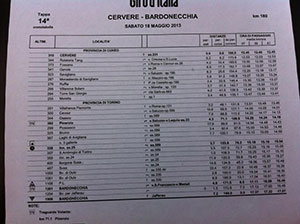
Instead of starting the climb towards Sestrière, the stage will change from Pinerolo and go on via Piossasco, Bruino, Laghi Avigliana and Susa before getting back on the initial race route in Oulx and go via Bardonnecchia up the final climb of Jafferau.Hereunder you'll find the new race route of this stage drawn in red on Google Maps, while the initially planned race route is drawn in bright bleu. The two intermediate sprints remain unchanged, while the feeding zone (not indicated on the map) will be on the ss.25 before Sant Ambrogio di Torino.
You can also check out the new time- and route schedule (thanks to Cédric Vasseur) and the new profile of the stage.


The new race route of the 14th stage of the Tour of Italy 2013 (Cervere > Bardonecchia) in Google Earth
If you prefer to see the new race route of this stage in Google Earth, click on the link below to download the corresponding KML file and open it in Google Earth:>> Download the new race route of the 14th Giro d'Italia 2013 stage in Google Earth
CONTINUE READING AFTER THIS ADVERTISEMENT
The 14th Tour of Italy 2013 (Cervere > Bardonecchia) stage on TV
Remember that, as every day, you can watch the race live (starts every day between 2.30PM and 3.00PM local time) on velowire.com: watch the Tour of Italy 2013 live. door Thomas VergouwenVond u dit artikel interessant? Laat het uw vrienden op Facebook weten door op de buttons hieronder te klikken!
4 comments | 6525 views
this publication is published in: Giro d Italia | Giro d'Italia 2013 | OpenStreetMap/Google Maps/Google Earth


 by Bernard over
  by Bernard over
Merci Thomas pour cette réactivité!
Merci Thomas pour le nouveau tracé, j'espère que tu auras également rapidement celui de demain.
Bonsoir Thomas,
le parcours de demain sera inchangé, à l'exception de l'arrivée qui se fera stèle Pantani et non pas au sommet. Donc seulement 4 km en moins.
Info du site du giro.
Effectivement, je n'étais donc pas loin dans mon résumé du jour ;-). Ou comme le dit Jérome Pineau :
Cela fera donc 4250 mètres de moins et une arrivée à une altitude de 2301 mètres au lieu de 2642. A voir si cela se passe ... sans problèmes ...