It's already the start of Paris-Nice 2017 tomorrow, the 75th edition of the "race to the sun", in Bois d'Arcy in the Yvelines department. 1,233.5 kilometers will be on the programme of this 5th race of the UCI WorldTour, with only one individual time trial, partly uphill with the finish on the Mont Brouilly.
This edition of Paris-Nice will reach summits which have never been reached in this race, with the Col de la Couillole which will be the finish location of the forelast stage next Saturday. So, on this race route, who will follow up on Geraint Thomas?
In any case, this article will provide you all the informations about the race route and you'll get to know it in detail, with the race route on Google Maps/Google Earth, the profiles of each of the stages and the time- and route schedules.
The Paris-Nice 2017 race route on Google Maps
CONTINUE READING AFTER THIS ADVERTISEMENT
1/ Sunday 5 March 2017 - Bois d'Arcy > Bois d'Arcy - 148.5 km
The first stage of Paris-Nice 2017 will start in the Yvelines department which receives the start of Paris-Nice since 2010, from Bois d'Arcy to be more precise, and it will also finish there. This will howver not be a time trial as you would expect for a stage which starts and finishes in the same city, but the first stage in line, with two laps on a circuit west of the city, with a total distance of 148.5 kilometers. After the start in the Avenue Paul Vaillant Couturier, the riders will go off south down to Dampierre-en-Yvelines, where the first stage of Paris-Nice 2012 started. After a short sidetrip towards Les Essarts-le-Roi they'll turn back around towards Senlisse where they'll climb the Côte de Senlisse (3rd categorie, 1.1 km @ 5.5%).Direction west then before to go back up north towards Beynes where they'll battle for the first intermediate sprint of this stage. They'll already be on their way back east towards Bois d'Arcy at that time and when they get there they won't cross the finish line but they'll continue to start the second lap on this circuit. Completely identical to the first lap, with the same climb and the same sprint, they'll turn left when they get back to Bois d'Arcy to cross the finish line this time and we'll then know who's the winner of this stage and therefore also the first rider to wear the yellow jersey of this Paris-Nice 2017.
Hereunder you'll find the time- and route schedule, the profile and the race route on Google Maps for the 1st stage of Paris-Nice 2017. Click on the images to open them.


2/ Monday 6 March 2017 - Rochefort-en-Yvelines > Amilly - 195 km
The second stage will also start in the Yvelines department, in Rochefort-en-Yvelines. Direction south, via Dourdan, the Côte des Granges-le-Roi and the intermediate sprint in Pussay before they'll continue south-east. Via Pithiviers the riders will then go on to the feeding zone in Coudroy and they'll continue east until Châtillon-Coligny before they go back up north. They'll then turn towards the finish city, Amilly, but before they get there they find the second intermediate sprint of this stage in Saint-Germain-des-Prés.When they cross the finish line the stage will however not be over yet because they'll still have to do a bit over thirty kilometers on a circuit around the finish city.
Hereunder you'll find the time- and route schedule, the profile and the race route on Google Maps for the 2nd stage of Paris-Nice 2017. Click on the images to open them.


3/ Tuesday 7 March 2017 - Chablis > Chalon-sur-Saône - 190 km
The 3rd stage of Paris-Nice 2017 will start in Chablis which already received a stage start of the Tour de France, in 2007.This stage will follow a track in south-eastern direction via the intermediate sprint in Époisses and the feeding zone in Éguilly. In the last part of the stage the riders will have to climb two difficulties, the Côte de Grandmont (3rd category, 2.4 km @ 4.9%) and the Côte de Charrecey (2nd category, 2.1 km @ 6.7%) but since the last one is at 25.5 kilometers from the finish it's highly probable that this stage will finish in a bunch sprint anyway in Chalon-sur-Saône. Before they get there, the riders will find the intermediate sprint in Mercurey.
Hereunder you'll find the time- and route schedule, the profile and the race route on Google Maps for the 3rd stage of Paris-Nice 2017. Click on the images to open them.


4/ Wednesday 8 March 2017 - Beaujeu > Mont Brouilly - individual time trial - 14.5 km
Immediately after that, Amaury Sport Organisation promised the local politicians that the race would come back in 2017 and that will thus be done this Wednesday 8 March 2017, not with a finish of a stage in line this time but with an individual time trial of 14.5 kilometers, starting in Beaujeu, which will thus finish with the climb of the Mont Brouilly, a 3 kilometer long climb at 7.7% of which the last kilometer shows slopes above 9%. The climb will thus start in Saint-Lager where the intermediate timing point will be located.
Hereunder you'll find the time- and route schedule, the profile and the race route on Google Maps for the 4th stage of Paris-Nice 2017. Click on the images to open them.


CONTINUE READING AFTER THIS ADVERTISEMENT
5/ Thursday 9 March 2017 - Quincié-en-Beaujolais > Bourg-de-Péage - 199.5 km
The start of the 5th stage in Quincié-en-Beaujolais will be at 11.45AM and the riders will go off straight south, via the intermediate sprint in Brindas and the feeding zone in Saint-Andéol-le-Château. After having visited Givors they'll climb the Côte de Givors (3rd category, 4.3 km @ 4.2%) before they continue their track towards the second intermediate sprint, which will be in Serrières.A bit furthere they'll climb the second difficulty of the day, which is the Côte de Saint-Uze, climb of the 2nd category (2.7 km @ 6.5%), at 47 kilometers from the finish in Bourg-de-Péage where the victory will probably be decided in a sprint.
Hereunder you'll find the time- and route schedule, the profile and the race route on Google Maps for the 5th stage of Paris-Nice 2017. Click on the images to open them.


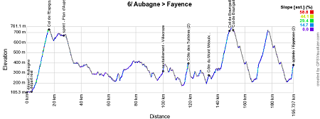
6/ Friday 10 March 2017 - Aubagne > Fayence - 193.5 km
After quite a big transfer to the south, a real climbers stage will be on the programme this Friday starting in Aubagne. This will be the first of three mountain stages which will end off Paris-Nice 2017.Hereunder you'll find the time- and route schedule, the profile and the race route on Google Maps for the 6th stage of Paris-Nice 2017. Click on the images to open them.


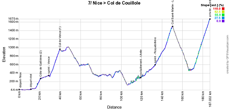
7/ Saturday 11 March 2017 - Nice > Col de la Couillole - 177 km
The day after this first mountain stage, a new mountain stage is on the programme this Saturday 11 March 2017 and this will be a quite difficult one, especially with the final part which contains two first category climbs of which the last one will be the highest point ever reached by Paris-Nice!!Starting in Nice, in the Avenue de Verdun (the stage starts and finishes in Nice will this year not be on the Promenade des Anglais out of respect for the victims of the terrorist attack on 14 July 2016) the riders will rapidly start the climb of the Côte de Gattières of the 2nd category (4.5 km @ 4.8%) before they get to the first intermediate sprint in Vence where they'll also climb the Col de Vence of the 1st category (9.7 km @ 6.6%).
After this first third of the stage a less hilly part will follow, but after the feeding zone in Utelle and the intermediate sprint in Roquebillière the real difficulties arrive, with two 1st category climbs, first the Col Saint Martin-La Colmiane (7.5 km @ 7.2%), immediately after the descent followed by the final climb of the Col de la Couillole (15.7 km @ 7.1%). Never before the Race to the sun (the nickname of Paris-Nice) had reached these heights and the 75th edition of the race will thus be celebrated at an altitude of 1,678 meters!
Hereunder you'll find the time- and route schedule, the profile and the race route on Google Maps for the 7th stage of Paris-Nice 2017. Click on the images to open them.


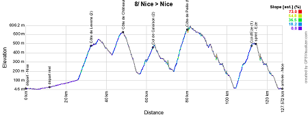
8/ Sunday 12 March 2017 - Nice > Nice - 115.5 km
The last stage of Paris-Nice 2017 will start and finish in Nice.The start will be at the same location as the day before and the stage which well end off the 75th edition of Paris-Nice will be short. 115.5 kilometers with no less than 5 climbs: the Côte de Levens (2nd category, 6.2 km @ 5.5%) which will be followed by the intermediate sprint in Levens, the Côte de Châteauneuf (2nd category, 5.4 km @ 4.4%) followed a bit further by the Col de Calaïson (2nd category, 6.3 km @ 4.4%).
There will still be two 1st category climbs on the programme, starting with the Côte de Peille (6.5 km @ 6.9%) and after a long descent the climb of the usual Col d'Eze (7.7 km @ 5.7%) (followed by the sprint in Eze) of which the summit will be at 15 kilometers from the finish line which will this time not be drawn on the Promenade des Anglais but on the Quai des Etats-Unis, still on the sea side.
Hereunder you'll find the time- and route schedule, the profile and the race route on Google Maps for the 8th stage of Paris-Nice 2017. Click on the images to open them.


The Paris-Nice 2017 race route in Google Earth
Hereabove you have discovered the race route of the Paris-Nice 2017 stages on Google Maps, as well as their stage profiles and corresponding time- and route schedules. If you'd like to see the full Paris-Nice 2017 race route at a glance or if you'd like to do a virtual fly-over over one or more stages for example, you'll find a link below which will allow you to download the Paris-Nice 2017 race route in Google Earth, thanks to the following KML file:>> Download the Paris-Nice 2017 race route in Google Earth

Vond u dit artikel interessant? Laat het uw vrienden op Facebook weten door op de buttons hieronder te klikken!
1 comment | 9111 views
this publication is published in: Paris-Nice | Paris-Nice 2017 | OpenStreetMap/Google Maps/Google Earth


 by Alpinebear over
  by Bernard over
Un grand merci !