In less than a week the Tour de France 2011 will start in the Vendée region for 3,430.5 kilometers in 21 stages. The 98th edition of the Grande Boucle will cross through France and pay a short visit to Italy before the usual finish on the Champs-Elysées in Paris.
In this article you'll find all details about the Tour de France 2011 race route with the maps in Google Maps, the stage profiles for each of the stages and the time- and route schedules.
With the KML file for Google Earth, you can even do a virtual fly-over over one or more of the stages as if you were there!
On the maps you'll also find the detailed route the riders will follow from the départ fictif to the départ réel. Finally you'll find the parking spots for the advertising caravan and all other important points of the stages.
 ATTENTION: all the contents of this article are protected by the usual copyright and you are thus not allowed to use the contents or parts of it without my prior approval. This concerns all texts, images and KML files. The KML files can in no case be used without the velowire.com logo and a link to this site in addition to my prior approval for you to use it.
WARNING: these maps have been developed based on the information provided by Amaury Sport Organisation. Unfortunately this information doesn't contain any details about the parcours in the cities the Tour crosses; there can thus be some tiny differences between the route the riders will follow and what's shown here (even though the number of mistakes should be quite limited). If you want to visit Tour I'd thus recommend you to ask locally where the race route is to make sure you won't miss the riders passing by!
The stages of the Tour de France 2011
In the table below you can find all stages of the Tour de France 2011. Click on each of the stages to find a short description of it, the stage profile, the map of the parcours on Google Maps and the time- and route schedule with the times the race crosses the different towns and cities of this 98th edition of the Tour de France.| # | type | datum | start | finish | distance |
|---|---|---|---|---|---|
| 1 | in line | Sa. 2 July 2011 | Passage du Gois La Barre-de-Monts | Mont des Alouettes Les Herbiers | 191,5 km |
| 2 | TTT | Su. 3 July 2011 | Les Essarts | Les Essarts | 23 km |
| 3 | in line | Mo. 4 July 2011 | Olonne-sur-Mer | Redon | 198 km |
| 4 | in line | Tu. 5 July 2011 | Lorient | Mûr-de-Bretagne | 172,5 km |
| 5 | in line | We. 6 July 2011 | Carhaix | Cap Fréhel | 164,5 km |
| 6 | in line | Th. 7 July 2011 | Dinan | Lisieux | 226,5 km |
| 7 | in line | Fr. 8 July 2011 | Le Mans | Châteauroux | 218 km |
| 8 | hilly | Sa. 9 July 2011 | Aigurande | Super-Besse Sancy | 189 km |
| 9 | hilly | Su. 10 July 2011 | Issoire | Saint-Flour | 208 km |
| R | repos | Mo. 11 July 2011 | Le Lioran Cantal | ||
| 10 | in line | Tu. 12 July 2011 | Aurillac | Carmaux | 158 km |
| 11 | in line | We. 13 July 2011 | Blaye-les-Mines | Lavaur | 167,5 km |
| 12 | mountain | Th. 14 July 2011 | Cugnaux | Luz-Ardiden | 211 km |
| 13 | mountain | Fr. 15 July 2011 | Pau | Lourdes | 152,5 km |
| 14 | mountain | Sa. 16 July 2011 | Saint-Gaudens | Plateau de Beille | 168,5 km |
| 15 | in line | Su. 17 July 2011 | Limoux | Montpellier | 192,5 km |
| R | repos | Mo. 18 July 2011 | département de la Drôme | ||
| 16 | hilly | Tu. 19 July 2011 | Saint-Paul-Trois-Châteaux | Gap | 162,5 km |
| 17 | mountain | We. 20 July 2011 | Gap | Pinerolo | 179 km |
| 18 | mountain | Th. 21 July 2011 | Pinerolo | Galibier Serre-Chevalier | 200,5 km |
| 19 | mountain | Fr. 22 July 2011 | Modane Valfréjus | Alpe d'Huez | 109,5 km |
| 20 | ITT | Sa. 23 July 2011 | Grenoble | Grenoble | 42,5 km |
| 21 | in line | Sa. 24 July 2011 | Créteil | Paris Champs-Elysées | 95 km |
Het parcours op Google Maps, de stageprofielen en de tijds- en routeschema's voor de stages of the Tour de France 2011
CONTINUE READING AFTER THIS ADVERTISEMENT
1/ Saturday 2 July 2011 : Passage du Gois / La Barre-de-Monts > Mont des Alouettes / Les Herbiers - 191.5 km
On Saturday 2 July 2011 the Tour de France 2011 will start with an official ceremony at the exit of the Passage du Gois. The Tour never knew a stage start before there and the finish is unique as well on the top of the Mont des Alouettes in Les Herbiers.This stage will follow the coast line down to les Sables-d'Olonne where the riders go land side and battle for the sprint in Avrillé just before they arrive in the feeding zone in Rosnay. In Réaumur the riders will again turn, this time northwards to the finish on top of the Mont des Alouettes just after Les Herbiers. The last kilometers of the stage contain several roundabouts and the stage will finish after a 2.2 kilometer long climb with an average steepness of 4.7%.
This finish, a 4th category climb, is the first climb of this Tour de France and the stage winner will thus also start leading the King of the Mountains classification!
This stage will completely take place in the Vendée region.
Below you'll find the time- and route schedule, the stage profile and the race route on Google Maps for this stage. Click on the images to open them.


2/ Sunday 2 July 2011 : Les Essarts > Les Essarts - 23 km
The second stage of this 98st edition of the Tour de France will take place as a team time trial. Around Les Essarts the 9 riders of each of the teams will do their collective effort. They'll do that on a completely flat route over a short distance, only 23 kilometers with an intermediate timing point in Boulogne and a second one in la Merlatière.At the finish of this stage the timings will be taken on the 5th rider crossing the finish line.
Below you'll find the time- and route schedule, the stage profile and the race route on Google Maps for this stage. Click on the images to open them.


3/ Monday 4 July 2011 : Olonne-sur-Mer > Redon - 198 km
The third stage of the Tour de France 2011 is the first stage which will not completely take place in the Vendée but it will start there, in Olonne-sur-Mer. 198 kilometers seperate this city from the finish in Redon.The stage will be relatively easy because the Pont de Saint-Nazaire and its 66 meters altitude will be the highest point of this stage. In the time- and route schedule this bridge is thus mentioned as teh Côte du Pont de Saint-Nazaire, in the fourth category. Most logically this stage should thus finish with a bunch sprint.
The feeding zone will be in Saint-Mars-de-Coutais and the intermediate sprint about twelve kilometers further, in Saint-Hilaire-de-Chaléons.
In addition to the Vendée, the riders will also visit the Loire-Atlantique and Ille-et-Vilaine departments during this stage.
Below you'll find the time- and route schedule, the stage profile and the race route on Google Maps for this stage. Click on the images to open them.


04/ Tuesday 5 July 2011 : Lorient > Mûr-de-Bretagne - 172.5 km
This fourth stage is slightly hilly and the organisor of the Tour followed its wish to have this stage finish with a quite steep climb to make sure the stages in this first week of the Tour will be interesting as well. It would thus well be possible that this stage between Lorient and Mûr-de-Bretagne will be won by a puncher who attacks in the last few kilometers and manages to stay ahead up to the finish.After the final climb, another climb is on the programme of this stage, the Côte de Laz. Just after this climb, the sprinters will battle for the points for the green jersey in Spézet where they also find the feeding zone.
The final climb is 2 kilometers long with an average steepness of 6.9%.
The departements which will be visited during this stage are the Morbihan, the Finistère and the Côtes d'Armor.
Below you'll find the time- and route schedule, the stage profile and the race route on Google Maps for this stage. Click on the images to open them.


CONTINUE READING AFTER THIS ADVERTISEMENT
5/ Carhaix > Cap Fréhel - 164.5 km
Again a 100% Britain stage between Carhaix and Cap Fréhel over a distance of 164.5 kilometers.The Côte de Gurunhuel early in this stage will not stop the sprinters from taking a spot at the front of the peloton in order to prepare a bunch sprint ... unless the peloton falls apart under the influence of the wind in the last part of the stage which follows the coast line.
The intermediate sprint will be in Goudelin and the feeding zone will be a few kilometers further, close to Pludual.
Below you'll find the time- and route schedule, the stage profile and the race route on Google Maps for this stage. Click on the images to open them.


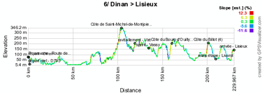
6/ Thursday 7 July 2011 : Dinan > Lisieux - 226.5 km
The sixth stage, between Dinan and Lisieux is the longest stage of this Tour de France 2011, just like the sixth stage of the Tour de France last year.Several climbs will make this stage's parcours interesting with especially the Côte de Saint-Michel de Montjoie (3), the Côte du Bourg d'Ouilly (3) and the Côte du Billot (4). Just after the first climb we'll find the feeding zone in Viré and the sprint in Vassy.
During this stage the riders will visit the departments Côtes d'Armor, Ille-et-Vilaine, Manche, Calvados and Orne.
Below you'll find the time- and route schedule, the stage profile and the race route on Google Maps for this stage. Click on the images to open them.


7/ Friday 8 July 2011 : Le Mans > Châteauroux - 218 km
Again a long stage this Friday, this time between Le Mans and Châteauroux over 218 kilometers.The start of this stage will take place just outside the circuit of Le Mans and despite the initial plans the riders will finally not ride over the circuit.
The riders will get new forces in the feeding zone of Chaumont-sur-Loire and the sprint will be in Buzançais, not far from the finish in the Avenue de la Châtre in Châteauroux.
Below you'll find the time- and route schedule, the stage profile and the race route on Google Maps for this stage. Click on the images to open them.


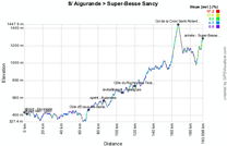
8/ Saturday 9 July 2011 : Aigurande > Super-Besse Sancy - 189 km
This eighth stage is the first hilly stage of the Tour de France, with its start in Aigurande. After the start the first part of this stage is flat, up to the foot of the Côte d'Evaux-les-Bains (4). After this climb, the parcours will continue uphill for a continuous climb up to the finish. On their way, the riders will find the Côte du Rocher des Trois Tourtes (4) and the Col de la Croix Saint-Robert (2) before they can start the final climb to Super-Besse Sancy (3).Below you'll find the time- and route schedule, the stage profile and the race route on Google Maps for this stage. Click on the images to open them.


CONTINUE READING AFTER THIS ADVERTISEMENT
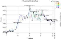
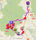
9/ Sunday 10 July 2011 : Issoire > Saint-Flour - 208 km
Yet another hilly stage this Sunday, from Issoire to Saint-Flour.The parcours of this stage will contain a lot of small climbs with the Côte de Massiac (3), the Col du Pas de Peyrol (Le Puy Mary) (2), the Col du Perthus (2), the Col de Cère (3), the Côte de la Chevade, the Col de Prat de Bouc (Plomb du Cantal), the Côte du Château d'Alleuze (4) and finally the climb of the Montée des Orgues (4) to the finish in Saint-Flour.
The feeding zone will be quite early in the stage, after only 81.5 kilometers in Dienne while the sprint will be in the last part of the stage, in Neuvéglise.
Below you'll find the time- and route schedule, the stage profile and the race route on Google Maps for this stage. Click on the images to open them.

R1/ Monday 11 July - rest day - Le Lioran Cantal
The first rest day, the teams will be in the Lioran area, where A.S.O. also organises the Oxygène Challenge.10/ Tuesday 12 July 2011 : Aurillac > Carmaux - 158 km
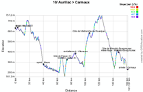
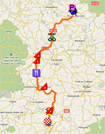
Between Aurillac and Carmaux, the riders will again find a hilly race route and they'll climb the Côte de Figeac (3), the Côte de Loupiac (4), the Côte de Villefranche de Rouergue (3) and finally the Côte de Mirandol Bourgnounac with a sprint early in the stage, in Maurs.The riders will be in the Cantal, in the Lot, in the Aveyron and finally in the Tarn today.
Below you'll find the time- and route schedule, the stage profile and the race route on Google Maps for this stage. Click on the images to open them.

11/ Wednesday 13 July 2011 : Blaye-les-Mines > Lavaur - 167.5 km
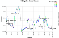
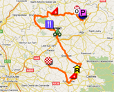
Probably one of the last possibilities for the sprinters to be upfront at the finish in Lavaur in this stage which starts in Blaye-les-Mines. Unless another rider attacks before and disturbs the plans of the sprinters of course.The Côte de Tonnac (3) and the Côte de Puylaurens (4) could help other riders to give it a try but the sprinters will most probably have enough time to come back to a possible breakaway. The feeding zone and the sprint will be halfway in the stage, respectively in Castelnau de Montmiral and in Gaillac.
In addition to the Tarn, where the stage will start and finish, the riders will also shortly visit the Tarn-et-Garonne.
Below you'll find the time- and route schedule, the stage profile and the race route on Google Maps for this stage. Click on the images to open them.

CONTINUE READING AFTER THIS ADVERTISEMENT
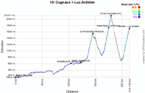
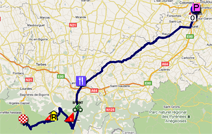
12/ Thursday 14 July 2011 : Cugnaux > Luz-Ardiden - 211 km
This twelfth stage is the first real mountain stage with its 3 cols: the Hourquette d'Ancizan (1), the Col du Tourmalet and the final climb to Luz-Ardiden.These three mountains will be in the second half of the stage and before the riders will get to climb these they'll pass the feeding zone in Lannemezan and they'll sprint in Sarrancolin.
3 departements will be visited during this stage: the Haute-Garonne, the Gers and the Hautes Pyrénées.
Below you'll find the time- and route schedule, the stage profile and the race route on Google Maps for this stage. Click on the images to open them.

13/ Friday 15 July 2011 : Pau > Lourdes - 152.5 km
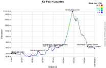
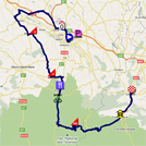
This stage will start relatively easily after the start in Pau, with the climb of the Côte de Cuqueron and the Côte de Belair. After the feeding zone in Sévignacq Meyracq and the sprint in Bielle, we'll find in this stage the climb of the Col d'Aubisque (HC). The top of this mountain will however be at more than 40 kilometers from the finish and the stage win could thus well be decided in the last few kilometers.Below you'll find the time- and route schedule, the stage profile and the race route on Google Maps for this stage. Click on the images to open them.

14/ Saturday 16 July 2011 : Saint-Gaudens > Plateau de Beille - 168.5 km
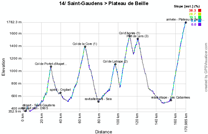
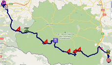
A last mountainstage before the riders leave the Pyrenees, between Saint-Gaudens and the Plateau de Beille. After 26.5 kilometers the riders will already be on the top of the Col de Portet d'Aspet (2). After the sprint in Orgibet, they'll continue with the Col de la Core (1) and after the feeding zone in Seix several mountains will follow one another, with the Col de Latrape (2), the Col d'Agnes (1) and the Port de Lers (3). After a quite long descent, the last 17 kilometers are again uphill towards the finish on top of the Plateau de Beille (HC).Below you'll find the time- and route schedule, the stage profile and the race route on Google Maps for this stage. Click on the images to open them.

15/ Sunday 17 July 2011 : Limoux > Montpellier - 192.5 km
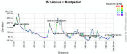
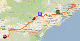
Before the finish on the Champs Elysées in Paris the finish in Montpellier really is the last opportunity for the sprinters to win a stage. After the start from Limoux this stage is almost completely flat, except for the climb of the Côte de Villespassans (4).The feeding zone will be in Cessenon sur Orb and the sprint in Montagnac. This stage will take place in the Aude and the Hérault departments.
Below you'll find the time- and route schedule, the stage profile and the race route on Google Maps for this stage. Click on the images to open them.

CONTINUE READING AFTER THIS ADVERTISEMENT
R2/ Monday 18 July 2011 - rest day - département de la Drôme
After having visited the Pyrenees and before continuing to the Alps, the riders can take some rest on this Monday 18 July, in the department of the Drôme.16/ Tuesday 19 July 2011 : Saint-Paul-Trois-Châteaux > Gap - 162.5 km
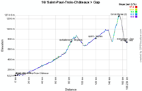
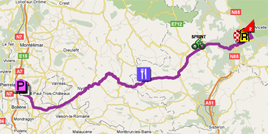
This stage is not very difficult in itself but it could well become a marathon session because the race route is almost continuously uphill from the start in Saint-Paul-Trois-Châteaux up to the finish in Gap.It doesn't happen often in the Tour de France, but the riders will pass close to the finish in Gap before continuing on a local circuit around the city where the stage will finish. The reason for this is that they can thus go find the only officially known climb of this stage, the Col de Manse (2).
The feeding zone will be in Moydans and the sprint in Veynes.
Below you'll find the time- and route schedule, the stage profile and the race route on Google Maps for this stage. Click on the images to open them.

17/ Wednesday 20 July 2011 : Gap > Pinerolo - 179 km
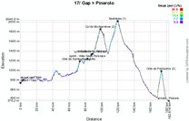
For the finish of this stage, which will start in the city where the Tour finished a stage the day before, Gap, the riders will go to the only foreign country which will be visited during this 98th edition of the Tour de France. This will be the first stage in the Alps and even though the Col de Montgenèvre and the climb of Sestrières will be the most important in this stage, the steep climb of the Côte de Pramartino could well play a decisive role in this stage.In France the riders will be in the Hautes-Alpes department and in Italy they'll be in the Province of Turin.
Below you'll find the time- and route schedule, the stage profile and the race route on Google Maps for this stage. Click on the images to open them.


18/ Thursday 21 July 2011 : Pinerolo > Galibier Serre-Chevalier - 200.5 km
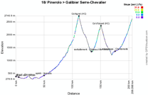
Yet another mountain stage in order to get back to France, via the Col d'Agnel (HC), the Col d'Izoard (HC) and finally the climb of the Col du Galibier (HC) where this stage will finish.After having left the Province of Turin, the riders will sprint early in this stage in Verzuolo in the Province of Cuneo. The stage will finish in the Hautes-Alpes in France and the riders can get something to eat just before the climb of the Izoard, in Château Ville Vieille.
Below you'll find the time- and route schedule, the stage profile and the race route on Google Maps for this stage. Click on the images to open them.

CONTINUE READING AFTER THIS ADVERTISEMENT
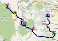
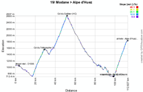
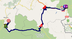
19/ Friday 22 July 2011 : Modane Valfréjus > Alpe d'Huez - 109.5 km
This forelast stage before the transfer to Paris is with its 109.5 kilometers quite short but contains the climbs of the Col du Télégraphe (1) and the Col du Galibier (HC) in the opposite direction of the day before and the final climb of the 21 bends of the Alpe d'Huez (HC). There will be no feeding zone in this stage which will take place in the Savoie, in the Hautes-Alpes and in the Isère but there will be a sprint, in Bourg d'Oisans at the foot of the final climb.Below you'll find the time- and route schedule, the stage profile and the race route on Google Maps for this stage. Click on the images to open them.

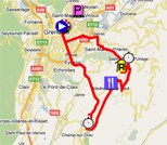
20/ Saturday 23 July 2011 : Grenoble > Grenoble - individal time trial - 42.5 km
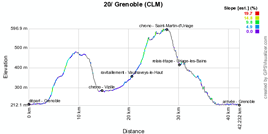
This stage will follow exactly the same route as the third stage of the Critérium du Dauphiné 2011. It was than won by Tony Martin (Team HTC-Highroad), followed by Bradley Wiggins and Edvald Boasson Hagen (Team Sky), but these riders might well not be on the podium of this stage in the Tour. This time trial will now come after 19 other stages and at the end of the 3-week stage race. The fatigue will thus be much more present and the time trial specialist might well leave the first places to the riders battling for a podium spot in the general classification of the Tour de France 2011.Below you'll find the time- and route schedule, the stage profile and the race route on Google Maps for this stage. Click on the images to open them.

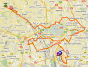
21/ Sunday 24 July 2011 : Créteil > Paris - Champs-Elysées - 95 km
The stage which will finish the Tour de France 2011 is very short and as usual not really interesting. The 95 kilometers which seperate Créteil from the last crossing of the finish line on the Champs-Elysées in Paris will be used to drink a glass of champagne and to send a smile to many screens worldwide (in 109 countries) in the TV camera!Below you'll find the time- and route schedule, the stage profile and the race route on Google Maps for this stage. Click on the images to open them.


The Tour de France 2011 race route, downloadable in Google Earth
Above you have discovered all details of the different stages of this 98th Tour de France including all time- and route schedules, the stage profiles and for all stages the race route on Google Maps.If you'd like to see the full parcours of the Tour de France 2011, you can download the KML file below and open it in Google Earth.
>> Download the Tour de France 2011 race route in Google Earth
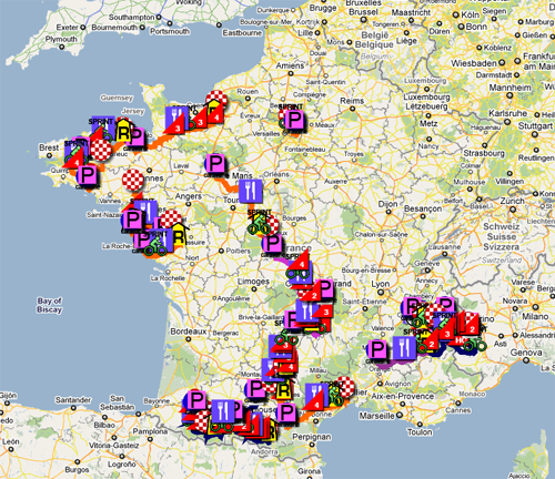
With this file you can not only watch the full race route in Google Earth but also do a virtual fly-over over one or more of the stages. door Thomas Vergouwen
Vond u dit artikel interessant? Laat het uw vrienden op Facebook weten door op de buttons hieronder te klikken!
23 comments | 46616 views
this publication is published in: Tour de France | Tour de France 2011 | OpenStreetMap/Google Maps/Google Earth


 by Galinier over
Il y a une erreur quant à l'étape Modane > L'Alpe d'Huez : le col du Galibier n'est pas escaladé jusqu'à son sommet comme la veille. Les coureurs emprunteront le tunnel situé plus bas (2556 mètres d'altitude) comme spécifié dans l'itinéraire horaire.
Effectivement, vous avez l'oeil ! C'est maintenant corrigé ...
De là à dire que c'est spécifié dans l'itinéraire horaire, je trouve ça un peu trop parce que si on fait un itinéraire horaire pour qu'il soit exploitable on précise le passage en tunnel comme le fait par exemple le Tour d'Italie !
Merci en tout cas de me l'avoir signalé !
Salut,
Tout d'abord merci pour la carte du Tour 2011! L'an passé je me suis rendu sur les étapes des pyrénées et j'avais tout planifié grâce à votre travail!Merci!
Cette année je compte me rendre sur les étapaes des Alpes (Galibier et Alpe d'Huez). On compte arriver déjà dans les alpes pour l'étape du mercredi. Pourriez-vous me dire svp si le Galibier et l'Alpe d'Huez possèdent des grands "parking" (prairie) dans lesquels on peut se garer et camper?
L'an passé au Tourmalet, c'est ce qui était prévu et donc cela nous avait permis de suivre les autres étapes et puis de venir au Tourmalet. La police nous laissait monter jusque dans ce parking...
Ou alors faut-il se parker dans un des 2 cols dès le mercredi??
Merci d'avance pour vos infos.
Pierre
Handig dit schema; kijk even bij je mail voor kleine aanpassingen.
Great to see your tdf route again - Over the years I've come to rely on it as an invaluable aid while watching on live broadcasts on TV.
Suggestion - info on distance to travel to the end of each stage would really help - say 70 km, 60 km, 50 km, .....20 km, 15 km, 10 km, 5km...
Regards,
Will Smith
Énorme boulot Thomas ! Pour avoir déjà un peu bricolé avec Gmap, je mesure totalement l'énormité du travail !! Comme chaque année un grand bravo !
Great to see the map covering this year's TDF. Previous years enjoyment has been improved immeasurably with your previous route maps.
Suggestion - embed distance to travel to the end of each stage - 80 km, 70 km, 60 km, 50 km, .....20 km, 15 km, 10 km, 5 km...
Je sais pas si tu es au courant, mais le Tour de France 2016 devrait partir du Yorkshire, un été du Nord-Est Britannique
La Manche, Glasgow (Écosse), Édimbourg (Écosse), le Pays de Galles sont candidats au départ du Tpur en 2017.
@Pierre (#3) : content de voir que ces informations vous ont été utiles l'année dernière, en espérant qu'elles le soient à nouveau cette année ! :-)
En ce qui concerne les parkings sur le Galibier et l'Alpe d'Huez : sur l'Alpe ce n'est pas vraiment le cas et il faudrait mieux y arriver assez tôt. Pour le Galibier, je crois qu'il y a un peu plus de place, mais je n'en suis pas vraiment certain non plus. Le mieux est donc probablement de contacter l'Office du Tourisme de Serre-Chevalier pour le leur demander.
@Will Smith (#5 & #7) : thanks for the suggestion. I will think about whether there's an easy way to add these in for future maps. Unfortunately I won't be able to do that anymore for the Tour de France since I'm already about to leave for the Tour !
@Thibault (#6) : bien vu effectivement ! Tu as devant toi le boulot de nombreuses soirée pendant plusieurs semaines et deux week-ends entiers. J'espère que l'article sera autant consulté que l'année dernière car au moins je saurai que je ne l'ai pas fait pour rien :-). À bientôt sur le Tour !
@Anonyme du 79 (#8 & #9) : tu pourrais t'identifier un peu plus ... même derrière un pseudo moins barbare ça le ferait mieux ;-). Tu m'apprends rien effectivement, mais ... rien n'est fait encore !
using kml velowire.com files I've create an application that shows riders position on Googlemaps.
En faite je suis un Deux-Sévriens (à côté de la Vendée) plus précisément un Bressuirais, j'ai 13 ans bientôt 14 et je suis sur plein de forum (pas que de vélo), mes pseudos sont rarement les mêmes et ma particularité c'est que personne me connait et mon identité n'a jamais été révélé (sous aucun pseudonyme).
Je hebt een mooie site over de tour maar hoe kom ik aan het KLM bestand voor Google Earth want dat is me niet duidelijk.
Groet,
Wim Hein
Wim, aan t eind van t artikel staat een link!
He Thomas... bedankt... ik heb er iedere keer overheen gekeken.
Ik zal er net als vorig jaar weer veel plezier aan beleven.
Groet,
Wim Hein
Update web application 'bikers geolocator': add automatic position every 60 seconds. http://blognoster.com/tour
Ciao
Honnêtement, au vu de la prestation de PHILIPPE GILBERT au Mont des Alouettes ce soir et en se rappelant sa victoire récente au Mur d'Huy, QUI PEUT LE BATTRE MARDI SOIR À MÛR DE BRETAGNE ? À mon humble avis : PERSONNE !!!
Contador perd une minute sur les frères Schleck. Le Tour démarre fort.
Contador n'a toujours pas compris qu'il doit être devant dans le peloton. Têtu le garçon !
Thomas, je tiens tout d'abord à vous féliciter pour votre gros travail afin de faire les cartes de toutes les étapes.
Ensuite, j'aurais une question à vous poser : comment faites-vous pour trouver les rues précises où sont jugées les arrivées des étapes ?
Love these.
For even more Google Earth fun, I've created a script that transmogrifies the real-time data feed from SRM at http://data.srmlive.de/TDF/ for use in Google Earth.
Anyone with a PHP capable server can use it, but I don't have the bandwidth to host it as a service. Instructions for use are in the file.
It can be found at http://pastebin.com/BnZUmiVd
@McEwen, désolé de ne pas avoir répondu plus tôt ... les informations sur les arrivées des étapes viennent tout simplement du roadbook du Tour de France dont j'avais pu télécharger la version électronique avant le Tour en utilisant mon accès presse.
dit jaar staat hij er weer mooi bij goed zo thomas
bonjour
il y a un moyen d'utiliser ce parcours avec un home trainer et le logiciel tacx trainer software. je me ferais bien un petit tour de France a vélo cet hiver.
si oui (ce serait trop beau) pouvez vous m'indiquer la demarche car je suis pas douer avec ces programmes.
merci d'avance
claude