With the Tour of Italy behind us, it is now time to see the Critérium du Dauphiné 2019 start from the Cantal department and more precisely from the city Aurillac. This will be the 71th edition of this race which is considered by some riders as the ultimate preparation race for the Tour de France (the organisor of the race now by the way even uses the subtitle "on the way to the Tour de France by the way; others will prefer the Tour of Switzerland which will start on 15 June) and it is made up of 8 stages of which one will be an individual time trial (the 4th stage, in the middle of the week) for a total distance of 1202.1 kilometers.
Let's now look in detail the different stages of this Critérium du Dauphiné 2019 with the race routes in Open Street Maps/Google Earth.
The Critérium du Dauphiné 2019 race route on Open Street Maps
CONTINUE READING AFTER THIS ADVERTISEMENT
1/ Sunday 9 June 2019 - Aurillac > Jussac - 142 km
The first stage of this Critérium du Dauphiné 2019 will take place in the Cantal department, starting in Aurillac. While the finish in Jussac is at only ten kilometers north of the start, it'll be a stage with a total distance of 142 kilometers.Very quickly, the riders will start the most difficult climb of this stage, a 1st category climb, the Puy Mary (10.6 km at 6.1%), of which the top will be reached after 34 kilometers. The 30 following kilometers will be downwards, via the intermediate sprint of Salers. Afte the climb of the Côte de Besse (4th category, 2.6 km at 5.2%) the riders can get some energy in the feeding zone in Saint-Chamant before they get to climb the Côte de Saint-Cernin (3rd category, 4.8 km at 4.3%).
Further on, the peloton will get on a local circuit around the finish city in which they'll have to climb - and thus two times - the Côte de Roquetanou (2nd category, 3.6 km at 7%).
Hereunder you'll find the time- and route schedule, the stage profile and the race route on Open Street Maps for the 1st stage of the Critérium du Dauphiné 2019. Click on the images to open them.


2/ Monday 10 June 2019 - Mauriac > Craponne-sur-Arzon - 180 km
The second stage of this Critérium du Dauphiné will start a few kilometers north of the previous day's finish city, in Mauriac. This stage is quite hilly, with no less than 8 climbs all along the stage, of which 5 in the first half of it: the Côte de Moussages (2nd), Côte de la Martel (3rd), Côte de Cheylade (3rd), Côte de la Tourbière du Jolan (4th) and the Côte de Chavanon (3rd). In the second half of the stage, after the feeding zone in Grenier-Montgon, the Côte de la Baraque (3rd), Côte de la Barbatte (2nd) and - after the intermediate sprint in La Chaise-Dieu - the Côte de Saint-Victor-sur-Arlanc (2nd) will be on the programme. The 18 last kilometers of the stage will be almost completely flat down to the finish in Craponne-sur-Arzon.Hereunder you'll find the time- and route schedule, the stage profile and the race route on Open Street Maps for the 2nd stage of the Critérium du Dauphiné 2019. Click on the images to open them.


3/ Tuesday 11 June 2019 - Le Puy-en-Velay > Riom - 177 km
From Le Puy-en-Velay, south of the finish location the day before, the riders will start the 3rd stage, and - after the Côte d'Allègre (4th category) and the intermediate sprint in La Chaise-Dieu close to the place where the race route crosses the one of the previous day's stage - it will go on via Ambert and the feeding zone in Job.In the second half of the stage, the riders will find 3 upfollowing climbs of the 4th category, the Côte d'Augerolles, the Côte de Courpière and the Côte de Coulaud but this will probably not prevent the finish to be a bunch sprint for this stage, especially because the top of the last climb is at about 60 kilometers from the finish in Riom. The intermediate sprint of the stage will be in Entraigues, at about fifteen kilometers from the finish.
Hereunder you'll find the time- and route schedule, the stage profile and the race route on Open Street Maps for the 3rd stage of the Critérium du Dauphiné 2019. Click on the images to open them.


4/ Wednesday 12 June 2019 - Roanne > Roanne - individual time trial - 26.1 km
In the middle of the week, Wednesday's stage will take place as an individual time trial, starting and finishing in Roanne, at the Scarabée, the event location of the city. The stage will take place at the west side of the city. The first half of this race against the clock is uphill, up to Saint-André-d'Apchon, and what follows is downhill until Pouilly-les-Nonains, before the final 7 kilometers which are flat until the finish in Roanne. The part between Saint-Alban-les-Eaux and the highest point of this stage and downhill part are the most wavy parts, but apart from that it's mostly straight routes which make up this time trial.Hereunder you'll find the time- and route schedule, the stage profile and the race route on Open Street Maps for the 4th stage of the Critérium du Dauphiné 2019. Click on the images to open them.


CONTINUE READING AFTER THIS ADVERTISEMENT
5/ Thursday 13 June 2019 - Boën-sur-Lignon > Voiron - 201 km
The 5th stage will be one of the longest stages of this Critérium du Dauphiné 2019 (only the next day's stage is longer), starting in Boën-sur-Lignon, south of Roanne, but this stage will not be particularly difficult. Indeed, after the four 4th category climbs, the Côte de Saint-Galmier, the Côte de Saint-Symphorien-sur-Coise, the Côte de Givors and the Côte de Vienne, and the feeding zone in Jardin, the rest will be pretty flat, with the intermediate sprint in Pajay and all the way through to the finish in Voiron.Hereunder you'll find the time- and route schedule, the stage profile and the race route on Open Street Maps for the 5th stage of the Critérium du Dauphiné 2019. Click on the images to open them.


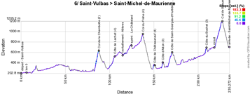
6/ Friday 14 June 2019 - Saint-Vulbas (Plaine de l'Ain) > Saint-Michel-de-Maurienne - 229 km
The longest stage of this Critérium du Dauphiné 2019, starting in Saint-Vulbas, will be on the programme this Friday 14 juin. This stage will first be flat, before it gets into the "massif des Bauges" where the riders will climb the Col de la Chambotte (5 km at 7.8%, 2nd category), the Côte de Lachat (4th) - followed by the feeding zone in Allèves and the intermediate sprint in Le Châtelard - the Col du Frêne (4th), the Côte de Châteauneuf (4th), the Côte d'Aiton (3rd) and the Côte de Saint-Georges-d'Hurtières (2nd category, 4.9 km at 5.9%).After a mostly easy part, only slightly going up, and a visit of Saint-Jean-de-Maurienne, the riders will get on the climb of the Côte du Bochet and on the circuit in which they'll rather quickly cross the finish line for the first time, before they go up north and climb the Col de Beaune (2nd category, 8.1 km at 5.6%), before going back south to the finish line in Saint-Michel-de-Maurienne.
Hereunder you'll find the time- and route schedule, the stage profile and the race route on Open Street Maps for the 6th stage of the Critérium du Dauphiné 2019. Click on the images to open them.


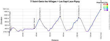
7/ Saturday 15 June 2019 - Saint-Genix-les-Villages > Les Sept Laux-Pipay - 133,5 km
A short but difficult stage this Saturday! After a transfer to the start in Saint-Genix-les-Villages on the other side of Chambéry, this stage will bring the riders first to Chambéry going around the Lac d'Aiguebelette on the south side and going via the intermediate sprint in Nances and the 1st category climb of the Col de l'Epine (7.6 km at 7.2%), on the south side of Chambéry until the foot of the Col du Granier (1st category, 12 km at 5.8%). After these two first category climbs following up on each other, another one will be awaiting the riders, the Col de Marcieu (10.4 km at 6.1%) and just after Tencin they'll start the final climb, outside category, towards the Les Sept Laux station and more precisely to its Pipay site.Hereunder you'll find the time- and route schedule, the stage profile and the race route on Open Street Maps for the 7th stage of the Critérium du Dauphiné 2019. Click on the images to open them.


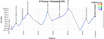
8/ Sunday 16 June 2019 - Cluses > Champéry (Suisse) - 113.5 km
The last stage of this Critérium du Dauphiné 2019 is the shortest one of this edition and even though it won't be the most difficult stage, it'll contain no less than two 1st category climbs, in addition to the 5 other difficulties of the 2nd (one) and 3rd (four) categories. It'll all start immediately after the start from Cluses with the Côte de Châtillon-sur-Cluses followed by the Côte de Rond which goes on into the climb Montée des Gets.After a long descent the first 1st category climb of this stage will be awaiting the riders, the Col du Corbier (7.6 km at 7.5%). After the descent and the intermediate sprint in La Chapelle-d'Abondance, the riders will go through Châtel where the start of the 2nd stage of the Critérium du Dauphiné 2013 took place and they'll get on the climb of the Pas de Morgins which will bring them to Switzerland. After the descent down to Monthey the second 1st category climb will be there, the Côte des Rives (8.5 km at 6.2%). The Montée de Champéry will be the only remaining climb and the riders will reach its summit at 1 kilometer from the finish in Champéry.
Hereunder you'll find the time- and route schedule, the stage profile and the race route on Open Street Maps for the 8th stage of the Critérium du Dauphiné 2019. Click on the images to open them.


The Critérium du Dauphiné 2019 race route in Google Earth
You have just discovered the race route of the Critérium du Dauphiné 2019 on Open Street Maps, as well as the stage profiles and the corresponding time- and route schedules. If you'd like to the see the full Critérium du Dauphiné 2019 race route in one total view or if you'd like to do a virtual fly-over of one or more of these stages for example, you'll find a link below which allows you to download the Critérium du Dauphiné 2019 race route in Google Earth, thanks to the following KML file:>> Download the Critérium du Dauphiné 2019 race route in Google Earth

Vond u dit artikel interessant? Laat het uw vrienden op Facebook weten door op de buttons hieronder te klikken!
2 comments | 11785 views
this publication is published in: Criterium du Dauphiné | OpenStreetMap/Google Maps/Google Earth


 by marco1988 over
Ready for LIVE race
Do you know how I might find GPS route files of the stages of the Dauphiné?
Thanks