The first Belgian classics have already taken place and now we're early April, it's already time for Flanders' Finest (Vlaanderens Mooiste), one of the nicknames the Tour of Flanders (Ronde van Vlaanderen) carries. Organised for the first time in 1913 and only temporarily stopped for the First World War, this race of course is a real monument among the Belgian classics.
Now Wout van Aert (Jumbo-Visma) is absent due to a Covid19 infection, his main competitors are probably very happy and started dreaming of a potential victory since chances are now higher for them!
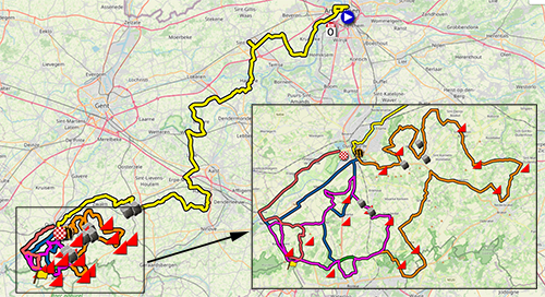
One Belgian candidate for the race win less but - even though the last 4 years it was always a winner from another country- Belgium still is the country with the biggest number of wins, 69 out of 105. As usual since 2017, the 106th edition will take place tomorrow between Antwerpen and Oudenaarde, over a total distance of 272.5 kilometers. Let's now have a detailed look at the race route of the Tour of Flanders 2022, which you can find below on Open Street Maps and which you can download in Google Earth.
CONTINUE READING AFTER THIS ADVERTISEMENT
The Tour of Flanders 2022 race route on Open Street Maps
The Tour of Flanders race route is mostly known for its hills which make the race that difficult, but also for its paved roads, and often even with the two combined.From the start in Antwerpen the riders first follow a flat race route of over 130 kilometers towards Oudenaarde, wherein they only find two paved sections, around Zottegem. It's only once they get to Oudenaarde and come by in front of the Center of the Tour of Flanders in that city, that they finally get in the area with the hills and where the race really becomes interesting. This first part of the race is drawn in yellow on the map.
The first part with the hills is drawn in blue, from Oudenaarde, Berchem and the first two hills, the Oude Kwaremont (2200 m of which 1500 m paved roads, 4% (max 11.6%)) and Kortekeer (1000 m - 6,2% (max 11%)) and back to Leupegem close to Oudenaarde.
From Leupegem they'll continue on the orange part on the map, which brings the riders via several paved sections but also over no less than 8 hills, the Achterberg (1500 m - 4.4% (max 14%)), the Wolvenberg (645 m - 7.9% (max 17.3%)), the Molenberg (463 m of which 300 m paved roads - 7% (max 14.2%)), Marlboroughstraat (2040 m - 3% (max 7%), the Berendries (940 m - 7% (max 12.3%)), the Valkenberg (540 m - 8.1% (max 12.8%)), the Berg Ten Houte (1100 m paved roads - 6% (max 21%)) and the Kanarieberg (1000 m - 7.7% (max 14%)).
The green part (almost invisible on the map since this is almost completely part of the pink part which follows as well) brings the riders via the Ronde van Vlaanderstraat (the street of the Tour of Flanders) via the Monument Karel van Wijnendaele (a sports journalist which made a huge contribution to make the race famous) and via Berchem almost back to the same point after a second climb of the Oude Kwaremont (2200 m of which 1500 m paved roads, 4% (max 11.6%)).
The last part full of hills is the pink part which continues from there to the Paterberg (360 m paved roads - 12.9% (max 20.3%)) before they get back towards Oudenaarde without however getting there this time (the race route remains within the route of the blue part), via the Koppenberg (600 m paved roads - 11.6% (max 22%)) before turning eastwards via other paved roads, including the climb of the Steenbeekdries (1100 m paved roads - 3.1% (max 7.6%)), followed by the Taaienberg (530 m of which 500 m paved roads - 6.6% (max 15.8%)). On the way back the race route gets a bit away from the previous route, getting closer to Ronse, but in the end it comes back on the usual route, with the climb of the Kruisberg / Hotond (2500 m of which 450 m paved roads - 5% (max 9%) and back via the Ronde van Vlaanderenstraat, Berchem and again the Oude Kwaremont (2200 m of which 1500 m paved roads, 4% (max 11.6%)).
The light red part goes on to the climb of the Paterberg (360 m paved roads - 12.9% (max 20.3%)) for the second time and the race route then goes beyond Berchem, over the Schelde river and on to Kerkhove, where the riders turn right before they continue on an almost straight line towards the finish line in Oudenaarde, which will be drawn in the Minderbroedersstraat.
Hereunder you'll find the time- and route schedule and the Tour of Flanders 2022 race route on Open Street Maps. Click on the images to open them.


The participants list of the Tour of Flanders 2022
Would you like to see who will come to the start of this 106th edition of the Flemish High Mass, another nickname of the Tour of Flanders 2022?>> Download the Tour of Flanders 2022 participants list
CONTINUE READING AFTER THIS ADVERTISEMENT
The Tour of Flanders 2022 race route in Google Earth
Do you prefer to see the race route of this Belgian classic in Google Earth and for example do a virtual fly-over of the race route? You can do so by downloading the KMZ file below:>> Download the Tour of Flanders 2022 race route in Google Earth

Vond u dit artikel interessant? Laat het uw vrienden op Facebook weten door op de buttons hieronder te klikken!
1 comment | 22598 views
this publication is published in: Classics | OpenStreetMap/Google Maps/Google Earth


 by marco1988 over
Bonjour
Est ce que le parcours 2023 sera disponible avant la course ?
Si oui savez vous comment le recuperer ?
Merci
Sportivmement
Olivier