It's less than a week away: the 111th edition of the Tour de France will set off from Firenze 🇮🇹 (Florence), arriving 3 weeks later in Nice, for the first finish in the history of the Grande Boucle anywhere other than Paris (Paris 2024 Olympic Games obliged).
So you're probably already looking forward to it: the publication with OpenStreetMap maps (equivalent to Google Maps) showing the routes of all the stages of the Tour de France 2024, zoomable to your heart's content, as well as time- and route schedules and stage profiles. And, of course, the file (KML / KMZ) to open in Google Earth to visualize the entire Grand Tour, or to fly over the stages as if you were there!
Now you can discover all the details of the 3,498 km that await the riders in their quest for the yellow jersey of the Tour de France 2024.
velowire.com once again offers you the chance to discover all the little details of the route of the Tour de France, which will be criss-crossing the roads of Italy and France for 3 weeks.... just like velowire.com, since as a consultant for Radio Sports you'll be able to listen to us every day throughout the Tour de France 2024 to discover all the details of the Tour and experience it in a different way! Of course, you'll be able to listen live on velowire.com, and in replay, as the home page will host a section of podcasts of the various broadcasts!
A little information first!
Before you discover the details of all the stages of the Tour de France 2024:- as with all content on velowire.com, its reproduction in any other form is prohibited, as specified on the copyright page. Thank you for respecting the time spent on preparing content such as this!
- stage profiles have been generated automatically on the basis of known altitude information at race locations; there may therefore be some inaccuracies, but the overall profile is correct!
- feed zones for the Tour de France 2024 are closed to the public; they are therefore not shown on the maps or in the timetable itineraries.
The program for the Grand Départ of the Tour de France 2024
As you know, the Grand Départ of the Tour de France 2024 will take place in Italy, in Florence Emilia-Romagna, and more precisely in Firenze (Florence) for the first stage. Here are the dates to remember for this Grand Départ of the Tour de France 2024:- Wednesday June 26, 2024: opening of the welcome desk and press center at the Teatro del Maggio Musicale Fiorentino in Florence, at 8:00 a.m. for the welcome desk and 2:00 p.m. for the press center, with a team press conference between 3:00 p.m. and 7:00 p.m. (as well as the following day between 9:00 a.m. and 4:00 p.m. and on Friday from 9:00 a.m. to 9:00 p.m. for the other teams).
- Thursday June 27, 2024:
- from 2pm to 9pm: opening of the Fan Park in Piazza Santa Croce, Florence - free admission
- 6:30 pm to 8:00 pm: presentation of the 22 Tour de France 2024 teams and their 176 riders, on the Piazzale Michelangelo in Florence, preceded by a 2.9 km bike parade that will allow the riders to access the Piazzale Michelangelo from the other side of the Fiume Arno (Arno River) via the Ponte alle Grazie, before descending from the stage and passing through the mixed zone (interviews), before returning to their hotel.
- Friday, June 28, 2024 - 11 a.m. to 9 p.m.: opening of the Fan Park in Florence's Piazza Santa Croce - free admission.
- Saturday June 29, 2024: 1st stage - Firenze 🇮🇹 (Florence) > Rimini 🇮🇹 with a fictitious start on Viale degli Olmi at 12:00, the official start ceremony in Piazza della Signoria at 12:10 and the actual start at 12:40, for a scheduled finish on Lungomare Giuseppe di Vittorio in Rimini at around 17:30.
- Sunday, June 30, 2024: Stage 2 - Cesenatico 🇮🇹 > Bologna 🇮🇹 (Bologna) with a fictional start on Viale Dino Ricci at 12:15pm and the actual start at 12:35pm, for an expected finish on Via Irnerio in Bologna (Bologna) shortly after 5pm.
- Monday, July 1, 2024: Stage 3 - Piacenza 🇮🇹 > Torino 🇮🇹 (Turin) with a fictitious start at the Viale Malta parking lot at 11:15 a.m. and the actual start at 11:35 a.m., with an expected finish on Corso Galileo Ferraris in Torino (Turin) around 5 p.m.
- Tuesday, July 2, 2024: Stage 4 - Pinerolo 🇮🇹 > Valloire 🇫🇷 with a fictitious start on Corso Torino at 1:05pm and the actual start at 1:15pm, crossing the border into France at around 3pm and an expected finish in the Avenue de la Vallée d'Or in Valloire at around 5:05pm.
The Tour de France 2024 route on OpenStreetMap
Let's get down to the nitty-gritty of the Tour de France 2024 route, stage by stage, with OpenStreetMap maps, stage profiles and time- and route schedules, so you can find out when the caravan and the race pass your preferred location. Whether you're at the side of the road or relaxing on your sofa in front of the TV, there's no excuse not to know the route of the Tour de France 2024:CONTINUE READING AFTER THIS ADVERTISEMENT
1/ Saturday June 29, 2024 - Firenze 🇮🇹 (Florence) > Rimini 🇮🇹 - 206 km
The first stage of the Tour de France 2024 will start in Firenze 🇮🇹 (Florence).After the fictitious start to the west of the city, the riders cross Florence until they reach the Piazza della Signoria, where the official start ceremony of the Tour de France 2024 will take place. After this, they head for the famous Ponte Vecchio, which they cross before making a short zig-zag circuit on the other side of the river and leaving the city to the east, towards the actual start of this first stage.
While the first 40km of this stage is just a very slight uphill, the first difficulty of the day begins, and the riders taking part in the Tour de France 2024 had better be in good shape, as there are no less than 7 difficulties awaiting them, for a total positive vertical raise of 3,600 metres! 3 2nd-category and 4 3rd-category climbs and passes punctuate this stage, which leaves little time for respite until just under thirty kilometers from the finish in Rimini 🇮🇹, after passing through San Marino 🇸🇲. The very last part of the stage is downhill, and the final kilometers are almost entirely flat.
Below you'll find the time schedule, profile and OpenStreetMap of the first stage of the Tour de France 2024. Click on images to enlarge.


- start:
- the start will take place in viale degli Olmi in Firenze 🇮🇹 (Florence) (12:00)
- the official start ceremony will take place in Piazza della Signoria (12:10), 4.3 km from the fictitious start and 12.1 km from the real start
- the real start is planned on SP34, 16.4 km from the meeting point (12:40)
- altitude gain: 3,600 m, with 47.2 km of difficulty listed as passes and climbs:
- Col de Valico Tre Faggi (2nd category) at km 49.7 - ^ 930 m / 12.5 km at 5.1
- Côte des Forche (3rd category) at km 77.8 - ^ 430 m / 2.5 km at 6.2%.
- Côte de Carnaio (3rd category) at km 98.3 - ^ 760 m / 10.5 km at 4.6%.
- Barbotto hill (2nd category) at km 135.6 - ^ 584 m / 5.8 km at 7.6%.
- Côte de San Leo (2nd category) at km 157.3 - ^ 572 m / 4.6 km at 7.7%.
- Côte de Montemaggio (3rd category) at km 167.1 - ^ 508 m / 4.2 km at 6.6%.
- Côte de San Marino (3rd category) at km 179.7 - ^ 648 m / 7.1 km at 4.8%
- intermediate sprint: via Nefetti to Santa Sofia at km 86.6
- finish: Lungomare Giuseppe di Vittorio in Rimini 🇮🇹, at the end of an 850 m straight line at sight / width 7 m
- departments crossed: Florence 🇮🇹 from km 0 to km 49.7, Forlì-Cesena 🇮🇹 from km 50 to km 137.1, Rimini 🇮🇹 from km 139.5 to km 167.1 and from km 188 to km 206, San Marino 🇸🇲 from km 168 to km 187.9
- main towns: Firenze 🇮🇹, Pontassieve 🇮🇹, Novafeltria 🇮🇹, San Marino 🇸🇲, Serravalle 🇮🇹 and Rimini 🇮🇹
2/ Sunday, June 30, 2024 - Cesenatico 🇮🇹 > Bologna 🇮🇹 - 199.2 km
The second stage of this 111th edition of the Tour de France will be a little milder than the previous one, starting from Cesenatico 🇮🇹 but not without its difficulties either: before Imola, where the riders will pass over the Autodromo Internazionale Enzo e Dino Ferrari circuit, they will first follow the coast on the flat, until Ravenna, where they will enter the land and climb two small difficulties (the second of which is quite steep though) followed by a part on the flat passing through the intermediate sprint, a passage over the 2020 World Championships road and two other small difficulties, but the most hard climb will be in the final circuit around Bologna 🇮🇹 : on 2 laps of an 18.8-kilometer circuit, they will twice climb the Côte de San Luca (1.9 km at 10.6%), known from the Tour of Emilia-Romagna (Giro dell'Emilia), which has its finish there.Below you'll find the schedule, profile and OpenStreetMap of the second stage of the Tour de France 2024. Click on images to enlarge.


- start:
- the start will be in Viale Dino Ricci in Cesenatico (12:15 p.m.)
- the actual start is scheduled on Lungomare Grazia Deledda, 9.5 km from the assembly point (12:35 p.m.)
- altitude gain: 1,850 m, with 11.6 km of difficulty listed as passes and climbs:
- Côte de Monticino (3rd category) at km 74 - ^ 250 m / 2 km at 7.5
- Côte de Gallisterna (3rd category) at km 88.8 - ^ 257 m / 1.2 km at 12.8%
- Côte de Botteghino di Zocca (4th category) at km 139 - ^ 242 m / 1.9 km at 6.9%.
- Côte de Montecalvo (3rd category) at km 151.2 - ^ 309 m / 2.7 km at 7.7%.
- Côte de San Luca (3rd category) at km 168.3 and km 186.6 - ^ 265 m / 1.9 km at 10.6%
- intermediate sprint: via Emilia, Toscanella in Dozza at km 108.1
- bonus sprint: Côte de San Luca, 2nd passage, 12.6 km from the finish
- finish: Via Irnerio in Bologna 🇮🇹, at the end of a 900 m straight final stretch on sight / 7 m wide
- departments crossed: Forlì-Cesena 🇮🇹 before km 0, Ravenna 🇮🇹 from km 0 to km 92.8, Bologna 🇮🇹 from km 93 to km 199.2
- main towns: Cesenatico 🇮🇹, Ravenna 🇮🇹, Faenza 🇮🇹, Imola 🇮🇹 and Bologna 🇮🇹
3/ Monday, July 1, 2024 - Piacenze 🇮🇹 > Torino 🇮🇹 (Turin) - 230.8 km
At the start in Piacenza 🇮🇹, the sprinters can finally start dreaming of a stage win. With the exception of 3 small 4th category climbs, the route will be fairly flat, and the peloton is likely to flock to the streets of Torino (Turin) 🇮🇹 for the battle for victory on stage 3. On their way they will pass through Tortone, the place where Fausto Coppi died and where they will be able to pay tribute to him on the eponymous climb. This stage will be the longest of the Tour de France 2024 at 230.8 kilometers.Below you will find the time schedule, profile and OpenStreetMap of the route of the third stage of the Tour de France 2024. Click on images to enlarge.


- start:
- the start will be from the Viale Malta parking lot in Piacenza 🇮🇹 (11:15 a.m.)
- the actual start is on SP10, 9.7 km from the meeting point (11:35 a.m.)
- altitude gain: 1,100 m, with 5.7 km of difficulty listed as passes and climbs:
- Côte de Tortone - Fausto Coppi (4th category) at km 70.8 - ^ 190 m / 1.1 km at 6.3
- Côte de Barbaresco (4th category) at km 156.1 - ^ 263 m / 1.5 km at 6.5%.
- Côte de Sommariva Perno (4th category) at km 181.4 - ^ 368 m / 3.1 km at 4.6%
- intermediate sprint: Spalto Gamondio / Corso Teresio Borsalino in Alessandria (Alexandria) at km 94.3
- finish: Corso Galileo Ferraris in Torino 🇮🇹 (Turin), at the end of a 700 m straight line (of which 500 m at sight) / width 7 m
- departments crossed: Piacenza 🇮🇹 from km 0 to km 16.2, Pavia 🇮🇹 from km 17 to km 50.7, Alessandria 🇮🇹 from km 51 to km 110.9, Asti 🇮🇹 from km 111 to km 131.5 and from km 140 to km 147.4, Cuneo 🇮🇹 from km 136.7 and from km 148 to km 191, Torino 🇮🇹 from km 192 to km 230.8
- main towns: Piacenza 🇮🇹, Alessandria 🇮🇹, Carmagnola 🇮🇹 and Torino 🇮🇹
4/ Tuesday, July 2, 2024 - Pinerolo 🇮🇹 > Valloire 🇫🇷 - 139.6 km
The start of stage 4 in Pinerolo 🇮🇹 is officially no longer part of the Grand Départ of this Tour de France 2024, but it will still be the last stage start in Italy 🇮🇹, before crossing the border into France for good.It will be a short stage at 139.6 kilometers. The Tour already visited Pinerolo in 2011, arriving from Gap and departing towards Galibier Serre-Chevalier.
Never before has the Tour climbed so high so early!
Christian Prudhomme
Director of the Tour de France
at the route presentation
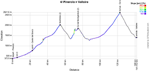
Quite soon into the stage, the road begins to rise, and there will be no real respite. The first summit to be reached is the resort of Sestrières (2035 m), and the border with France will be reached after the Col de Montgenèvre (1860 m).
The journey into France begins with a descent, followed by the long ascent of the Col du Lautaret before branching off to the Col du Galibier (2642 m).
Below you'll find the time schedule, profile and OpenStreetMap of the fourth stage of the Tour de France 2024. Click on images to enlarge.


- start:
- start on Corso Torino in Pinerolo 🇮🇹 (1:05pm)
- the actual start is on SR23, 4 km from the assembly point (12:25 p.m.)
- altitude gain: 3,600 m, with 71.2 km of difficulty listed as passes and climbs:
- Sestrières (2nd category) at km 50.4 - ^ 2,035 m / 39.9 km at 3.7
- Col de Montgenèvre (2nd category) at km 71.1 - ^ 1,860 m / 8.3 km at 5.9%.
- Col du Galibier (outside category) at km 120.7 - ^ 2,642 m / 23 km at 5.1%
- intermediate sprint: SP23R at Castel del Bosco at km 18.9
- bonus sprint: Col du Galibier, which will also be the location for the Souvenir Henri Desgrange
- finish: Avenue de la Vallée d'Or in Valloire, at the end of a 220 m straight final stretch on sight / width 5.50 m
- departments crossed: Torino 🇮🇹 from km 0 to km 68.4, Hautes-Alpes (05) from km 69 to km 119, Savoie (73) from km 120 to km 139.6
- main towns: Pinerolo 🇮🇹, Sestrière, Briançon and Valloire
CONTINUE READING AFTER THIS ADVERTISEMENT
5/ Wednesday, July 3, 2024 - Saint-Jean-de-Maurienne > Saint-Vulbas (Plaine de l'Ain) - 177.4 km
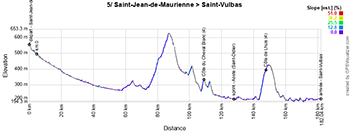
The 5th stage of the Tour de France 2024 will already leave the Alps, departing from Saint-Jean-de-Maurienne, where the Tour de France returns 5 years after the aborted stage initially headed for Tignes.In 2024, from Saint-Jean-de-Maurienne it will be on to the Plaine de l'Ain (in the department ... of Ain). As the name of this community of communes already indicates, it's on the flat that they'll arrive in Saint-Vulbas, and it's logical that this first Wednesday of the Tour de France 2024 will once again be a stage for sprinters.
Below you'll find the itinerary, profile and OpenStreetMap of the fifth stage of the Tour de France 2024. Click on images to enlarge.


- start:
- the start will be on Rue Jean Jaurès in Saint-Jean-de-Maurienne (1:20pm)
- the actual start is on the D1006, 4.6 km from the meeting point (1:30 p.m.)
- altitude gain: 1,050 m, with 4.5 km of difficulty listed as hills and passes:
- Côte du Cheval Blanc (4th category) at km 104.6 - ^ 335 m / 1.5 km at 4.3
- Côte de Lhuis (4th category) at km 142.8 - ^ 383 m / 3 km at 4.8%.
- intermediate sprint: D592 / Route de Belley à Aoste (Saint-Didier) at km 123.2
- finish: Avenue des Bergeries (D77) in Saint-Vulbas, at the end of a 2.2 km final straight (including 250 m at sight) / width 6.50 m
- departments crossed: Savoie (73) from km 0 to km 116.9, Isère (38) from km 117 to km 123.2, Ain (01) from km 124 to km 159.7
- main towns: Saint-Jean-de-Maurienne, Chambéry and Saint-Vulbas
6/ Thursday, July 4, 2024 - Mâcon > Dijon - 163.5 km
After a 4th category pass at the start of the stage, the 6th stage from Mâcon has flat roads for the first 80 km, lined with vineyards. The stage finishes on a wide and sufficiently long final straight in Dijon, logically with a bunch sprint finish.Below you'll find the time schedule, profile and OpenStreetMap of the sixth stage of the Tour de France 2024. Click on images to enlarge.


- start:
- the start will take place on Quai Lamartine in Mâcon (1:35pm)
- the actual start is on the D17, 8.1 km from the meeting point (1:50 p.m.)
- altitude gain: 1,000 m, with 1.6 km of difficulty listed as hills and passes:
- Col du Bois Clair (4th category) at km 10 - ^ 396 m / 1.6 km at 6% gradient
- intermediate sprint: Route de Chalon à Cormatin at km 31.1
- finish: Cours Général de Gaulle in Dijon, at the end of a 600 m / 7 m wide final straight
- departments crossed: Saône-et-Loire (71) from km 0 to km 77.7 and km 97.3, Côte-d'Or (21) from km 78 to km 95.9 and km 100 to km 163.5
- main towns: Mâcon, Cluny and Dijon
7/ Friday, July 5, 2024 - Nuits-Saint-Georges > Gevrey-Chambertin - individual time trial - 25.3 km
The Friday of the first week of the Tour de France 2024 features an individual time-trial stage. Starting in Nuits-Saint-Georges, after passing through the town in a quasi-loop, the riders pass through the forest before arriving in the vineyards and fields. A further passage through the forest takes them to the 3rd intermediate timing point, before crossing numerous vineyards to the finish in Gevrey-Chambertin.Below you'll find the time itinerary, profile and OpenStreetMap for the seventh stage of the Tour de France 2024. Click on images to enlarge.


- start:
- the start will be on Route de Dijon / D974 in Nuits-Saint-Georges (1:05 pm for the first rider, 5:00 pm for the last rider)
- starts are from 1' to 1' then from 1'30" to 1'30" and from 2' to 2' for the last riders
- altitude gain: 300 m, with no difficulties listed
- finish: Place des Maronniers in Gevrey-Chambertin, at the end of a 160 m straight finish at sight / width 4.50 m
- departements crossed: Côte-d'Or (21) from km 0 to km 25.3
- main towns: Nuits-Saint-Georges and Gevrey-Chambertin
8/ Saturday, July 6, 2024 - Semur-en-Auxois > Colombey-les-Deux-Églises - 183.4 km
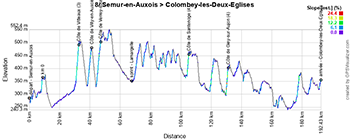
Stage 8 gets underway in the medieval town of Semur-en-Auxois, and 5 classified climbs punctuate the race over the first two-thirds of the stage, including 3 very close together at the start (between km 22 and 39).Once again, this should be an opportunity for sprinters, as the last part of the stage is fairly flat, even if the sprinter who wants to win this stage must be a strong man, as the last few hectometres are a false flat climb towards the finish in Colombey-les-Deux-Eglises. Colombey-les-Deux-Eglises has never before hosted the Tour de France for a stage start or finish, but the race passed through here in 1960 on the stage between Besançon and Troyes, when President General de Gaulle crashed into the crowd. It's a famous passage because Jacques Godet, then director of the Tour de France, was warned of it and decided to halt the peloton's progress so that he could greet the President. The President paid tribute to the race by saluting the riders and the race itself.Below you'll find the timetable, profile and OpenStreetMap of the eighth stage of the Tour de France 2024. Click on images to enlarge.


- start:
- the start will be at Rue de la Liberté in Semur-en-Auxois (1:05pm)
- the actual start is on the D9, 8.7 km from the assembly point (1:20 p.m.)
- altitude gain: 2,400 m, with 9.6 km of difficulty listed as hills and passes:
- Côte de Vitteaux (3rd category) at km 24.1 - ^ 493 m / 2 km at 7.3
- Côte de Villy-en-Auxois (4th category) at km 32.5 - ^ 480 m / 2.4 km at 5.5%
- Côte de Verrey-sous-Salmaise (3rd category) at km 38.8 - ^ 518 m / 2.9 km at 6%
- Côte de Santenoge (4th category) at km 96.7 - ^ 459 m / 1.1 km at 8.1%
- Côte de Giey-sur-Aujon (4th category) at km 122.4 - ^ 396 m / 1.2 km at 8.4%
- intermediate sprint: Route de Pellerey à Lamargelle at km 59
- finish: D619 at Colombey-les-Deux-Eglises, at the end of a 1.8 km straight line at sight / width 6.50 m
- departments crossed: Côte-d'Or (21) from km 0 to km 87.2, Haute-Marne (52) from km 88 to km 183.4
- main towns: Semur-en-Auxois, Chaumont, Bologne and Colombey-les-Deux-Eglises
CONTINUE READING AFTER THIS ADVERTISEMENT
9/ Sunday, July 7, 2024 - Troyes > Troyes - 199 km
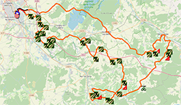
Stage 9 of the Tour de France 2024, the last of the first week, is special in more ways than one. Not only will the stage start and finish in Troyes, but it will also feature no fewer than 14 white roads, covering a total distance of 32.2 km out of a total 199.It's rare to see a loop stage in the Tour de France, and it's unheard of to have white roads, let alone so many of them. It's a stage where you won't win the Tour de France 2024 but various things (from a puncture to mechanical problems) can make you lose the Tour here! At km 47.3, the riders arrive on the first white road (numbered 14, as they are numbered from high to low towards the finish) and leave the last white road just 6.5 km from the finish in Troyes.
Below you'll find the time schedule, profile and OpenStreetMap for the ninth stage of the Tour de France 2024. Click on images to enlarge.


- start:
- the start will be at Rue de la République in Troyes (1:15pm)
- the actual start is on the D161, 8 km from the assembly point (1:35 p.m.)
- altitude gain: 2,000 m, with 8.1 km of difficulty listed as hills and passes:
- Côte de Bergères (4th category) at km 51.7 - ^ 335 m / 1.7 km at 5.2
- Côte de Baroville (4th category) at km 69.6 - ^ 363 m / 2.8 km at 4.8%.
- Côte de Val Frion (4th category) at km 105.2 - ^ 280 m / 2.2 km at 5%.
- Côte de Chacenay (4th category) at km 121.2 - ^ 314 m / 3 km at 4.3%.
- white roads (the number of stars indicates the difficulty of the white road) :
- 14/ chemin blanc from Bligny to Bergères - * - 2000 m
- 13/ chemin blanc de Baroville - *** - 1200 m
- 12/ chemin blanc des Hautes Forêts - ** - 1500 m
- 11/ chemin blanc from Polisy to Celles-sur-Ource - *** - 3400 m
- 10/ white trail from Loches-sur-Ource to Chacenay - *** - 4200 m
- 9/ white trail from Plateau de la Côte des Bar - * - 2200 m
- 8/ white trail from Thieffrain to Magnant - *** - 3900 m
- 7/ Briel-sur-Barse white trail - * - 2200 m
- 6/ chemin blanc du Ru de Paradis - * - 1200 m
- 5/ white road from Fresnoy-le-Château to Clérey - * - 1800 m
- 4/ chemin blanc des Verrières - * - 1500 m
- 3/ chemin blanc de Daudes - * - 1900 m
- 2/ chemin blanc from Montaulin to Rouilly-Saint-Loup - ** - 2200 m
- 1/ chemin blanc de Saint-Parres-aux-Tertres - ** - 3000 m
- intermediate sprint: Rue Pasteur à Fontette at km 81.6
- finish: Boulevard du 1er Régiment d'Artillerie de Montagne in Troyes, at the end of a 230 m straight final stretch at sight / width 6 m
- departments crossed: Aube (10) from km 0 to km 199
- main towns: Troyes, Vendeuvre-sur-Barse and Bar-sur-Aube
R1/ Monday July 8, 2024 - rest in Orléans
After this long and difficult week, and a journey of just over 200 kilometers, the riders will be able to rest for the first time in this Tour de France 2024, in Orléans.10/ Tuesday July 9, 2024 - Orléans > Saint-Amand-Montrond - 187.3 km
It has been almost a quarter of a century since the Tour de France has stopped in Orléans (the last time was in 2001). The route to Saint-Amand-Montrond will be almost entirely flat, so the finish could be a bunch sprint. Saint-Amand-Montrond, at the foot of its famous pyramid, is a place where the Tour has passed through more recently... and near the finish in 2013, when the wind on the flat roads before the finish caused some riders to drop out. 11 years later, Mark Cavendish, who won the stage in 2013, is looking to take his 35th stage victory in the Tour de France, to finally beat the record he co-holds with Eddy Merckx, and for which he would like to beat the absolute record, before he finishes his career at the end of the year. Will the fond memories of Saint-Amand-Montrond be enough for him to exact his revenge here?Below you'll find the time schedule, profile and OpenStreetMap for the tenth stage of the Tour de France 2024. Click on images to enlarge.


- start:
- the start will be at Place Halmagrand in Orléans (1:05pm)
- the actual start is on the D168, 8.7 km from the assembly point (1:25 p.m.)
- altitude difference: 950 m, no difficulties listed
- intermediate sprint: Avenue de Paris in Romorantin-Lanthenay at km 57.1
- finish: D951 / Rue Pelletier Doisy in Saint-Amand-Montrond, at the end of a final 500 m straight line at sight / width 6.50 m
- departments crossed: Loiret (45) from km 0 to km 21.4, Loir-et-Cher (41) from km 22 to km 77.9, Cher (18) from km 78 to km 103.4 and from km 137 to km 187.3, Indre (36) from km 104 to km 136.6
- main towns: Orléans, Romorantin-Lanthenay, Vierzon, Issoudun and Saint-Amand-Montrond
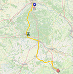
11/ Wednesday, July 10, 2024 - Évaux-les-Bains > Le Lioran - 211 km
Unlike its predecessor, the 11th stage from the spa town of Evaux-les-Bains will not be reserved for sprinters. From the Creuse department, which is back on the Tour de France for the first time in 20 years, it heads into the Massif Central, and while the first three-quarters of the stage are not so difficult, the bulk of the 4.350 metres of climbing takes place in the last 45 kilometers, starting with the Col de Néronne (1242 m), followed by the Puy Mary Pas de Pérol (1589 m, 1st category) and finally the Col de Pertus (1309 m) and the Col de Font de Cère (1294 m) before arriving at the resort of Le Lioran (1242 m) (and although there is a short descent after the Col de Font de Cère, the last kilometer of the stage is uphill).Below you'll find the itinerary, profile and OpenStreetMap of the eleventh stage of the Tour de France 2024. Click on images to enlarge.
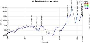

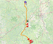
- start:
- the start will be on Rue de Verdun in Évaux-les-Bains (11:20 a.m.)
- the actual start is on the D996, 4.5 km from the assembly point (11:30 a.m.)
- altitude gain: 4,350 m, with 19.6 km of difficulty listed ascols and côtes:
- Côte de Mouilloux (4th category) at km 79.8 - ^ 715 m / 1.9 km at 6.3
- Côte de Larodde (3rd category) at km 89.7 - ^ 803 m / 3.8 km at 6%.
- Col de Néronne (2nd category) at km 168.7 - ^ 1242 m / 3.8 km at 9.1%.
- Puy Mary Pas de Peyrol (1st category) at km 180 - ^ 1589 m / 5.4 km at 8.1%.
- Col de Pertus (2nd category) at km 196.4 - ^ 1309 m / 4.4 km at 7.9%.
- Col de Font de Cère (3rd category) at km 208.2 - ^ 1294 m / 3.3 km at 5.8%.
- intermediate sprint: D987 at Bourg-Lastic at km 65
- bonus sprint: Col de Pertus
- finish: D67 at Le Lioran, at the end of a final 160 m straight at sight / width 5.50 m
- departments crossed: Creuse (23) from km 0 to km 28, Puy-de-Dôme (63) from km 28.2 to km 98.6, Cantal (15) from km 99 to km 108.6 and from km 115 to km 211, Corrèze (19) from km 109 to km 115
- main towns: Évaux-les-Bains, Auzances, Dontreix, Bourg-Lastic, Bort-les-Orgues and Le Lioran
CONTINUE READING AFTER THIS ADVERTISEMENT
12/ Thursday, July 11, 2024 - Aurillac > Villeneuve-sur-Lot - 203.6 km
After the stage finish in the Cantal, the start of this 12th stage takes place in the prefecture of Aurillac.From the Cantal, the riders head for the Lot and Lot-et-Garonne, on an undulating course, including the climb to Rocamadour. In the second part of the stage, the sprinters will find suitable terrain for a bunch sprint, but they'll have to catch up with the breakaway riders before the finish in Villeneuve-sur-Lot!
Below you'll find the itinerary, profile and OpenStreetMap of the twelfth stage of the Tour de France 2024. Click on images to enlarge.
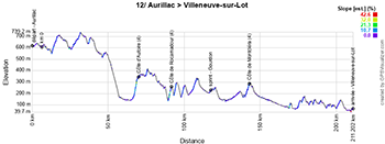

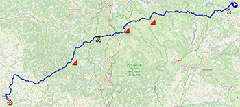
- start:
- the start will be on Avenue Gambetta in Aurillac (12:35 p.m.)
- the actual start is on the N122, 6.3 km from the assembly point (12:25 p.m.)
- altitude gain: 2,200 m, with 6.7 km of difficulty listed ascols and côtes:
- Côte d'Autoire (4th category) at km 62.8 - ^ 349 m / 2.7 km at 5.9
- Côte de Rocamadour (4th category) at km 84.3 - ^ 265 m / 2 km at 5.8%.
- Côte de Montcléra (4th category) at km 135.5 - ^ 286 m / 2 km at 4.6%.
- intermediate sprint: Boulevard de la Madeleine in Gourdon at km 110
- finish: D911 at Villeneuve-sur-Lot, at the end of a 1.2 km straight finish at sight / width 6.50 m
- departments crossed: Cantal (15) from km 0 to km 30, Lot (46) from km 30 to km 157.8, Lot-et-Garonne (47) from km 158 to km 203.6
- main towns: Aurillac, Le Rouget, Saint-Céré, Alvignac, Rocamadour, Gourdon, Cazals, Fumel, Monflanguin and Villeneuve-sur-Lot
13/ Friday, July 12, 2024 - Agen > Pau - 165.3 km
From Agen, the starting point for this 13th stage, the riders embark on a course with balcony roads in the Lot-et-Garonne département, before crossing the Gers département into the Pyrénées-Atlantiques. The intermediate sprint on this stage will take place in Nogaro, where stage 4 of the Tour de France 2023 ended.The sprinters' teams may not have been fooled by the start of the race or managed to catch any breakaways, but they will still have to defend their place in the stage final, where the Côte de Blachon and Côte de Simacourbe could prevent their sprinters from going all the way to Pau for victory.
Below you'll find the itinerary, profile and OpenStreetMap for the thirteenth stage of the Tour de France 2024. Click on images to enlarge.


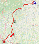
- start:
- the start will be on Avenue du Général de Gaulle in Agen (1:30pm)
- the actual start is on the D7, 9.2 km from the meeting point (1:50 p.m.)
- altitude gain: 2,000 m, with 3.3 km of difficulty listed ascols and côtes:
- Côte de Blachon (4th category) at km 127 - ^ 309 m / 1.5 km at 6.9
- Côte de Simacourbe (4th category) at km 136.3 - ^ 316 m / 1.8 km at 6.4%.
- intermediate sprint: Avenue de Daniate in Nogaro at km 88.5
- finish: Rue du Maquis Le Béarn in Pau, at the end of a final 560 m straight at sight / width 7 m
- departments crossed: Lot-et-Garonne (47) from km 0 to km 50, Landes (40) from km 50 to km 60, Gers (32) from km 60 to km 108.9, Hautes-Pyrénées (65) from km 109 to km 116, Pyrénées-Atlantiques (64) from km 117 to km 165.3
- main towns: Agen, Nérac, Nogaro and Pau
14/ Saturday, July 13, 2024 - Pau > Saint-Lary-Soulan - Pla d'Adet - 151.9 km
To kick off this second weekend of the Tour de France 2024, a beautiful Pyrenean stage awaits the riders, also starting from Pau. While the first half of the stage presents no particular difficulties, that all changes for the second half of the stage, where a fine triptych of Pyrenean passes awaits the riders. It begins with the Col du Tourmalet (2115 m), and as soon as the descent is complete, it's on to the Hourquette d'Ancizan (1564 m), whose descent is followed by a short passage through the valley, before tackling the final climb to the high-altitude finish in Saint-Lary-Soulan at the Pla d'Adet (1669 m), where the 50th anniversary of Raymond Poulidor's last stage victory in the Tour de France will be celebrated. With this, this stage offers a total positive vertical drop of 4000 m.Below you'll find the time itinerary, profile and OpenStreetMap of the route of the fourteenth stage of the Tour de France 2024. Click on images to enlarge.
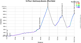

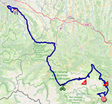
- start:
- the start will be on Avenue Gaston Lacoste in Pau (1:05pm)
- the actual start is on the D802, 7.3 km from the assembly point (1:20 p.m.)
- altitude gain: 4,000 m, with 37.8 km of difficulty listed ascols and côtes:
- Col du Tourmalet (out of category) at km 89.6 - ^ 2115 m / 19 km at 7.4
- Hourquette d'Ancizan (2nd category) at km 123.4 - ^ 1564 m / 8.2 km at 5.1%.
- Saint-Lary-Soulan - Pla d'Adet (non-category) at km 151.9 - ^ 1669 m / 10.6 km at 7.9%.
- intermediate sprint: Avenue du Barège in Esquièze-Sère at km 70.2
- finish: Route du Plat d'Adet in Saint-Lary-Soulan - Pla d'Adet, at the end of a final 80 m straight at sight / width 5 m
- departments crossed: Pyrénées-Atlantiques (64) from km 0 to km 25, Hautes-Pyrénées (65) from km 25 to km 151.9
- main towns: Pau, Lourdes, Argelès-Gazost, Pierrefitte-Nestalas, Luz-Saint-Sauveur and Saint-Lary-Soulan
15/ Sunday, July 14, 2024 - Loudenvielle > Plateau de Beille - 197.7 km
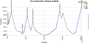
The final stage of this second week of the Tour de France 2024 will also be a Pyrenean stage. And what a stage it will be on this national holiday: no fewer than 5 climbs await the riders, the first of which starts as soon as they leave Loudenvielle: the climb to the Col de Peyresourde (1569 m), followed by the Col de Menté (1349 m) and the steepest part of the Col de Portet-d'Aspet (1069 m).After a short breather, they then find the Col d'Agnes (1570 m) and after a descent and a final valley passage, they then find themselves at the foot of the final ascent to the high altitude finish at Plateau de Beille (1780 m, almost 16 km at 8% average). All in all, this will be the most mountainous day of the Tour de France 2024, with a total of 4,800 m of positive vertical drop!
Below you'll find the time schedule, profile and OpenStreetMap of the 15th stage of the Tour de France 2024. Click on images to enlarge.


- start:
- the start will be at Chemin de Rioutor in Loudenvielle (11:55 a.m.)
- the actual start is on the D618, 4 km from the meeting point (12:25 p.m.)
- altitude gain: 4,800 m, with 46.3 km of difficulty listed as passes and climbs:
- Col de Peyresourde (1st category) at km 7 - ^ 1569 m / 6.9 km at 7.8
- Col de Menté (1st category) at km 50 - ^ 1349 m / 9.3 km at 9.1%.
- Col de Portet-d'Aspet (1st category) at km 65.4 - ^ 1069 m / 4.3 km at 9.6%.
- Col d'Agnes (1st category) at km 138.6 - ^ 1570 m / 10 km at 8.2%.
- Plateau de Beille (outside category) at km 197.7 - ^ 1780 m / 15.8 km at 7.9%.
- intermediate sprint: Rue Jean Jaurès in Marignac at km 37
- finish: D522 at Plateau de Beille, at the end of a final 60 m straight at sight / width 5.50 m
- departments crossed: Hautes-Pyrénées (65) from km 0 to km 7, Haute-Garonne (31) from km 7 to km 67.4, Ariège (09) from km 68 to km 197.7
- main towns: Loudenvielle, Bagnères-de-Luchon, Cierp-Gaud, Marignac, Castillon-en-Couserans, Saint-Girons, Vicdessos and Tarascon-sur-Ariège
CONTINUE READING AFTER THIS ADVERTISEMENT
R2/ Monday July 15, 2024 - rest in Gruissan
Another well-deserved rest day awaits the riders, officially in Gruissan, although many will probably be staying in Narbonne.16/ Tuesday July 16, 2024 - Gruissan > Nîmes - 188.6 km
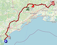
After a good rest, this Tuesday, July 16, 2024 stage from Gruissan is likely to be a sprinter's one.Only one climb is officially referenced on the course of this 16th stage, and it's around 75 kilometers from the finish. Not enough to thwart the sprinters' plans for a massive finish in Nîmes. On the other hand, perhaps the mistral wind could give rise to a few breaks!
Below you'll find the time- and route schedule, profile and OpenStreetMap of the route of stage 16 of the Tour de France 2024. Click on images to enlarge.


- start:
- the start will be on Boulevard du Pech Maynaud in Gruissan (1:05pm)
- the actual start is on the D1118, 12.5 km from the assembly point (1:30 p.m.)
- altitude gain: 1,200 m, with 1.2 km of difficulty listed as passes and hills:
- Côte de Fambetou (4th category) at km 112.6 - ^ 242 m / 1.2 km at 5% gradient
- intermediate sprint: D32 at Les Matelettes at km 96.1
- finish: Boulevard du Président Salvador Allende in Nîmes, at the end of a 360 m straight finish at sight / width 6.50 m
- departments crossed: Aude (11) from km 0 to km 8, Hérault (34) from km 9 to km 134, Gard (30) from km 134 to km 188.6
- main towns: Gruissan, Béziers, Pézenas, Saint-Martin-de-Londres, Sommières, Vergèze and Nîmes
17/ Wednesday, July 17, 2024 - Saint-Paul-Trois-Châteaux > SuperDévoluy - 177.8 km
After this gentle recovery, stage 17 of the Tour de France 2024 begins - after the start in Saint-Paul-Trois-Châteaux (which is beginning to establish itself as a regular starter with this 5th in 15 years) - over three-quarters of the distance on a gradual climb, still gentle, but then things get tougher. Two cols are on the program, before the final climb to Superdévoluy.Below you'll find the time itinerary, profile and OpenStreetMap of the route of the seventeenth stage of the Tour de France 2024. Click on images to enlarge.
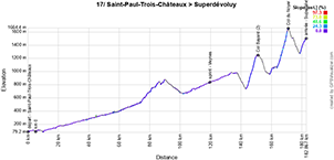

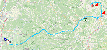
- start:
- the start will be on the Cours des Platanes in Saint-Paul-Trois-Châteaux (12:35pm)
- the actual start will be on the D59, 5km from the meeting point (12:45pm)
- altitude gain: 2.850 m, with 18.1 km of difficulty listed passes and climbs:
- Col Bayard (2nd category) at km 145.7 - ^ 1246 m / 6.8 km at 7.3% Col du Noyer (1st category) at km 166.3 - ^ 1664 m / 7.5 km at 8.1%
Superdévoluy (3rd category) at km 177.8 - ^ 1502 m / 3.8 km at 5.9%
18/ Thursday, July 18, 2024 - Gap > Barcelonnette - 179.5 km
Starting from Gap, it's the last chance for sprinters, but the stage offers several difficulties, which a puncheur could take advantage of to get away and, who knows, maybe win this 18th stage to Barcelonnette.Below you'll find the time itinerary, profile and OpenStreetMap of the eighteenth stage of the Tour de France 2024. Click on images to enlarge.
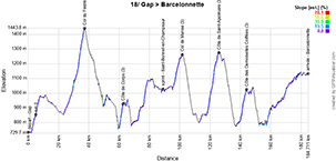

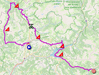
- start:
- the start will be on Avenue de Traunstein in Gap (1:00 pm)
- the actual start will be on the D994, 5.2 km from the assembly point (1:20 pm)
- altitude gain: 3.100 m, with 21.7 km of difficulty listed as passes and hills:
- Col du Festre (3rd category) at km 32.2 - ^ 1441 m / 3.9 km at 6.3% Côte de Corps (3rd category) at km 57.5 - ^ 930 m / 2.1 km at 7.2%
Col de Manse (3rd category) at km 97.3 - ^ 1280 m / 5,1 km at 3.6%Côte de Saint-Apolinaire (3rd category) at km 121 - ^ 1286 m / 7 km at 5.5%Côte des Demoiselles Coiffées (3rd category) at km 139.1 - ^ 1031 m / 3.6 km at 5.4%
CONTINUE READING AFTER THIS ADVERTISEMENT
19/ Friday, July 19, 2024 - Embrun > Isola 2000 - 144.6 km
From Embrun, a regular starting point for the Tour de France, the 19th stage will be a short but beautiful one in the Alps, with no less than 3 difficulties, mainly outside category and each over 2000 meters in altitude, awaiting the riders. These include the Cime de la Bonette, the highest road in France at 2,802 meters above sea level, which will be the roof of the Tour de France 2024!Below you'll find the timetable, profile and OpenStreetMap for the nineteenth stage of the Tour de France 2024. Click on images to enlarge.
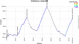

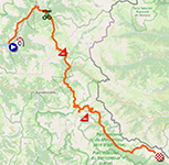
- start:
- the start will be on Avenue des Acacias in Embrun (12:20pm)
- the actual start is on the D944H, 3.5 km from the meeting point (12:30 p.m.)
- altitude gain: 4,400 m, with 57.8 km of difficulty listed aspasses and climbs:
- Col de Vars (out of category) at km 42.6 - ^ 2109 m / 18.8 km at 5.7%.
- Cime de la Bonette (non-category) at km 87.5 - ^ 2802 m / 22.9 km at 6.9%.
- Isola 2000 (1st category) at km 144.6 - ^ 2024 m / 16.1 km at 7.1%.
- intermediate sprint: Route de la Gare in Guillestre at km 21.1
- finish: Avenue du Mercantour in Isola 2000, at the end of a 270 m straight finish at sight / width 5 m
- departments crossed: Hautes-Alpes (05) from km 0 to km 42.6, Alpes-de-Haute-Provence (04) from km 42.6 to km 86.4, Alpes-Maritimes (06) from km 86.4 to km 144.6
- main towns: Embrun, Jausiers and Isola 2000
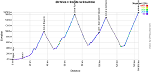
20/ Saturday, July 20, 2024 - Nice > Col de la Couillole - 132.8 km
The penultimate stage of the Tour de France 2024 will be the shortest road stage of this 111th edition of the Tour de France, at 132.8 kilometers. Although short, it won't be easy: no fewer than 4 climbs await the riders at the start from Nice. No less than 40.5% of the stage will be uphill.If the overall classification isn't decided by then, the battle for the yellow jersey will be fierce on this stage... until the final decision is made the following day!
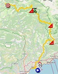
Below you'll find the time schedule, profile and OpenStreetMap of the twentieth stage of the Tour de France 2024. Click on images to enlarge.

- start:
- the start will be at Quai des Deux Emmanuel in Nice (1:35pm)
- the actual start is scheduled on the M2204B, 11.9 km from the assembly point (12:25 p.m.)
- altitude gain: 4,600 m, with 53.9 km of difficulty listed aspasses and climbs:
- Col de Braus (2nd category) at km 24.7 - ^ 1002 m / 10 km at 6.6
- Col de Turini (1st category) at km 59.8 - ^ 1607 m / 20.7 km at 5.7%.
- Col de la Colmiane (1st category) at km 95.9 - ^ 1500 m / 7.5 km at 7.1%.
- Col de la Couillole (1st category) at km 132.8 - ^ 1678 m / 15.7 km at 7.1%.
- intermediate sprint: Route de la Vésubie in Saint-Martin-Vésubie at km 87.8
- finish: M30 at Col de la Couillole, at the end of a 70 m straight final stretch at sight / width 5 m
- departments crossed: Alpes-Maritimes (06) from km 0 to km 132.8
- main towns: Nice, La Trinité, Sospel, La Bollène-Vésubie, Roquebillière, Saint-Martin-Vésubie, Saint-Dalmas, Valdeblore and Saint-Sauveur-sur-Tinée
21/ Sunday, July 21, 2024 - Monaco 🇲🇨 > Nice - individual time trial - 33.7 km
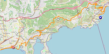
The very last stage will take the form of a selective, and potentially decisive, individual time trial of no less than 33.7 kilometers and with difficulty, between Monaco 🇲🇨 and Nice!During this solo event, the riders will climb up to La Turbie and then to the Col d'Eze, to measure themselves against each other and to decide in which state the stopwatches will be stopped on the Place de Masséna in Nice, where this individual time trial will finish.
Below you will find the time itinerary, profile and OpenStreetMap of the route of the twenty-first stage of the Tour de France 2024. Click on images to enlarge.


- start:
- the launch ramp will be positioned on Boulevard Albert 1er in Monaco 🇲🇨 (2:40 p.m. for the first rider, 6:45 p.m. for the last rider)
- starts will be from 1' to 1' then from 1'30" to 1'30" and from 2' to 2' for the last riders
- timetables have been calculated at 45 km/h for 160 starters; depending on the number of riders remaining, timetables may be adjusted
- altitude gain: 650 m, with 9.7 km of difficulty referenced in climbs and passes:
- La Turbie (2nd category) at km 11.2 - ^ 480 m / 8.1 km at 5.6
- Col d'Eze (not listed) at km 17.1 - ^ 508 m / 1.6 km at 8.1%.
- finish: Place Massena in Nice, at the end of a 60 m straight final stretch at sight / width 4 m
- departments crossed: Monaco 🇲🇨 from km 0 to km 3.7, Alpes-Maritimes (06) from km 3.7 to km 33.7
- main towns: Monaco 🇲🇨, La Turbie, Eze and Nice
The Tour de France 2024 route in Google Earth
Would you prefer to see the entire route of the Tour de France 2024 on a single map? Or would you like to take a virtual flight over the route of one or more stages of this 111th edition of the Tour de France? All this is possible, by downloading the KMZ file (a zipped KML file, due to its large size) below and opening it in Google Earth (warning: make sure you're using the desktop version of Google Earth; if you open it in Google Earth in your browser, it won't work properly)! ATTENTION - copyright: although this KMZ/KML file is provided for your own use, please note that it is strictly forbidden to reproduce the content of this KMZ/KML file or any other file (including maps, profiles, KML files and others) that make up the Tour de France 2024 route provided by velowire.com. These contents are indeed protected by copyright and I ask you to respect the important time spent on their creation. This protection therefore concerns the reproduction of maps and other elements in any form whatsoever (in the form of maps, videos flying over the maps or any other creation based on the content published on velowire.com).
>> Download the route of all the stages of the Tour de France 2024 in Google Earth (KMZ file; IMPORTANT: if the download does not start, copy the address https://short.thover.com/?ID=934 and paste it into a new browser window, then press enter)

Tour de France 2024 teaser
Between the Ponte Vecchio in Firenze (Florence), Jonas Vingegaard (Team Visma | Lease a Bike), Tadej Pogačar (UAE Team Emirates), Primož Roglič (BORA-hansgrohe) and Remco Evenepoel (Soudal Quick-Step), it's a beautiful picture that awaits us for the Tour de France 2024, and that's what we see in the official teaser:Vond u dit artikel interessant? Laat het uw vrienden op Facebook weten door op de buttons hieronder te klikken!
4 comments | 17012 views
this publication is published in: Tour de France | Tour de France 2024 | OpenStreetMap/Google Maps/Google Earth


 by marco1988 over