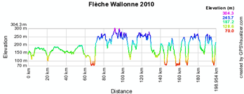
Tomorrow the 74th edition of the Flèche Wallonne will take place between Charleroi and Huy. The route of the race has been slightly changed compared to the past and this classic promises to be even more difficult than before!
Indeed, the order of the 2 loops around the Mur de Huy has been inversed and the second climb of the Mur de Huy is thus situated at no less than 30 kilometers from the final climb. In addition to this, the Côte d'Ereffe has been added in the route for 2010.
In this article you can find the Flèche Wallonne 2010 route on Google Maps / Google Earth, the profil of the race and the time and route schedule.
Below you can find the route on Google Maps, the profile and the time and route schedule (which gives you the times the race passes through the different villages and cities) of the Flèche Wallonne 2010. Click on each of the images to open them:


CONTINUE READING AFTER THIS ADVERTISEMENT
The Flèche Wallonne 2010 route in Google Earth
Would you prefer to view the route in Google Earth and thus be able for example to make a virtual fly-over over it? Download the KML file below to do so:> Download the Flèche Wallonne 2010 route in Google Earth
This file will not only allow you to visualise the whole route in Google Earth but also to do a virtual fly-over over the route. To do so, you can of course use the default configuration for Google Earth, but if you would like to do a virtual fly-over as if you were riding on the roads of the Flèche Wallonne 2010, I would recommend the following settings: in the menu Tools > Options choose the tab Touring and fill in the following choices on that tab:
- Camera tilt angle : 80.0 degrees
- Camera range : 150.0 meters
- Speed : 500.0 (if this makes you feel dizzy or if your computer or Internet connection don't allow you to get clear images with these settings, you can try lowering the speed) door Thomas Vergouwen
Vond u dit artikel interessant? Laat het uw vrienden op Facebook weten door op de buttons hieronder te klikken!
2 comments | 7697 views
this publication is published in: Classics | OpenStreetMap/Google Maps/Google Earth


 by marco1988 over
http://www.cyclisme-roltiss-over.com/article-le-parcours-de-la-fleche-wallonne-2010-sur-google-maps-google-earth-et-l-itineraire-horaire-48992708.html
il y a une erreur ds le parcours, après la côte d'ereffe, le peloton prend le chemin du comte pour rejoindre la N641