Mid-April I already announced you the 2010 Critérium du Dauphiné route (at that time I also informed you of the name change, the French race losing the word Libéré in its name, we thus no longer talk about the Critérium du Dauphiné Libéré), today I'm pleased to allow you to discover - as usual now for the different cycling races - the 2010 Critérium du Dauphiné routes on Google Maps/Google Earth.
Le Dauphiné will take place from Sunday 6 until Sunday 13 June from Evian-les-Bains to Sallanches. The queen stage is the one on Saturday 12 June from Crolles to Alpe d'Huez. The famous climb with its 21 hairpins is in the center of the Dauphiné region but still, this will be the very first time this climb is part of the Critérium du Dauphiné !
The stages of the Critérium du Dauphiné 2010
Below you can find a table with the 7 stages and the prologue of the 2010 Critérium du Dauphiné. Click on each of the stages to read a short description, see the profile of the stage, the route on Google Maps and the route- and time schedules which indicate the time at which the riders will pass in the different cities and villages visited by the 2010 Critérium du Dauphiné.| # | type | date | start | finish | distance |
|---|---|---|---|---|---|
| P | prologue | Su. 6 June 2010 | Evian-les-Bains | Evian-les-Bains | 6.8 km |
| 1 | in line | Mo. 7 June 2010 | Evian-les-Bains | Saint-Laurent-du-Pont | 191 km |
| 2 | in line | Tu. 8 June 2010 | Annonay | Bourg-Saint-Andéol | 177 km |
| 3 | contre-la-montre individuel | We. 9 June 2010 | Monteux | Sorgues | 49 km |
| 4 | in line | Th. 10 June 2010 | Saint-Paul-Trois-Châteaux | Risoul | 210 km |
| 5 | in line | Fr. 11 June 2010 | Serre-Chevalier | Grenoble | 143,5 km |
| 6 | in line | Sa. 12 June 2010 | Crolles | Alpe d'Huez | 151.5 km |
| 7 | in line | Su. 13 June 2010 | Allevard-les-Bains | Sallanches | 148 km |
The route on Google Maps, the stage profiles and the route- and time schedules for the stages of the 2010 Critérium du Dauphiné
CONTINUE READING AFTER THIS ADVERTISEMENT
P/ Evian-les-Bains > Evian-les-Bains - 6.8 km
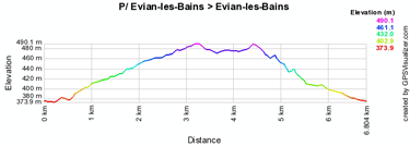
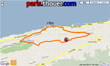
The Critérium du Dauphiné 2010 will start on Sunday 6 June 2010 with a prologue in the streets of Evian-les-Bains over a distance of 6.8 kilometers on a track which seems, apart from the two bends at almost 360° on both end sides of the track, not to be very technical but it does propose a climb with a 109 meter height difference (the top of this climb is on the Chemin de Chez Constantin). This climb is of the 4th category and is 2.4 kilometers long with an average climb of 4.3%.The intermediate time point of this stage is also on the top of this climb.
The riders will start on the Quai Baron-de-Blonay and than follow the Avenue d'Abondance, Neuvecelle, the Avenue du Léman, the Boulevard du Royal, the Route du Golf, the Route de Bissinges towards the finish on the Avenue Anna-de-Noailles in the front of the Town hall.
- You can find local information about this stage on:
> the site of the city Evian-les-Bains
Below you can find the time- and route schedule, the stage profile and the route of this stage on Google Maps. Click on each of the images to open it.

1/ Evian-les-Bains > Saint-Laurent-du-Pont - 191 km
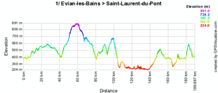
The first stage will take the riders on Monday 7 June from Evian-les-Bains to Saint-Laurent-du-Pont over a distance of 191 kilometers. Just after passing close to Genève, the riders will start 3 climbs: the Côte de Mornex (2.3 km with an average climb of 5.3%, 4th category), the Côte de Sallenôves (1.4 km also with an average climb of 5.3%, 4th category) and the Côte de Chilly (1.7 km with an average climb of 7.7%, 3rd category). At the end of the stage they'll climb the Côte de Miribel-les-Echelles of the 3rd category (3 km with an average climb of 6.6%).The stage contains two intermediate sprints: at the start of the stage in Cruseilles and at the very end of the stage in Les Echelles. The feeding zone is in Seyssel.
In Saint-Laurent-du-Pont the riders will follow the Route de Miribel, the Route de Villette and finally towards the finish on the Avenue Jules Ferry.
- You can find local information about this stage on:
> the site of the city Evian-les-Bains
> the site of Saint-Laurent-du-Pont
Below you can find the time- and route schedule, the stage profile and the route of this stage on Google Maps. Click on each of the images to open it.


2/ Annonay > Bourg-Saint-Andéol - 177 km
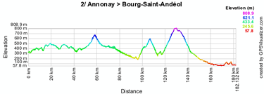
To connect Annonay to Bourg-Saint-Andéol in 177 kilometers, the riders will firsdt follow the Avenue de l'Europe, the Rue Montgolfier and the Rue Boissy d'Anglas before continuing south, visiting for example Privas and climbing the Côte de Saint-Jeure-d'Ay (2.1 km with an average climb of 5.8%, 4th category), the Col des Nonières (4.7 km with an average climb of 4%, 3rd category) and 2 longer climbs: the Col du Moulin-à-Vent of 10.5 km with an average climb of 4% (2nd) and the Col du Benas of 10.6 km with an average climb of 4.8% (2nd).The intermediate sprints will be around the middle of the stage, in Le Cheylard and in Privas, while the feeding zone will be exactly in the middle of the stage, in Le Moulinon.
The stage finish will be on the Avenue Maréchal Leclerc.
- You can find local information about this stage on:
> the site of Annonay
> the agenda of the city Bourg-Saint-Andéol
Below you can find the time- and route schedule, the stage profile and the route of this stage on Google Maps. Click on each of the images to open it.


3/ Monteux > Sorgues - individual time trial - 49 km
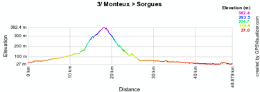
The 3rd stage of this 62nd edition of the Critérium du Dauphiné will be an individual time trial between Monteux and Sorgues over a distance of 49 kilometers. The riders will climb the Côte de la Roque-sur-Pernes (1.9 km with an average climb of 6,8%, 3rd category) in this individual effort and on its top will be the first intermediate time checkpoint. The second intermediate time checkpoint will be in Velleron and there will be a feeding zone close to Fontaine-de-Vaucluse.After the start from the Place du Marché the riders follow the Boulevards Belle Croix, Verdun, Foch and René Cassin before they continue on the Route de Pernes. The riders will enter Sorgues via the Route d'Entraigues before continuning on the Boulevard Allende and turn on the Avenue Charles de Gaulle towards the finish in the Rue de la Coquille at the Bouscarle parking.
- You can find local information about this stage on:
> the site of the city Monteux
> the site of Sorgues and Sorgues' newsletter
Below you can find the time- and route schedule, the stage profile and the route of this stage on Google Maps. Click on each of the images to open it.


CONTINUE READING AFTER THIS ADVERTISEMENT
4/ Saint-Paul-Trois-Châteaux > Risoul - 210 km
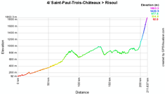
Direction west this Thursday to connect Saint-Paul-Trois-Châteaux to the first mountain top finish of this Critérium du Dauphiné 2010 in Risoul. There are no other climbs in this stage and it is thus well possible that a possible leading group will be taken back just before the final 1st category climb towards Risoul. The intermediate sprints are in Rosans and in Chorges while the feeding zone will be in Pont-le-Buëch. The final climb is 12.8 kilometers long with an average climb of 7%.- You can find local information about this stage on:
> the site of Saint-Paul-Trois-Châteaux
> the site of Risoul 1850
Below you can find the time- and route schedule, the stage profile and the route of this stage on Google Maps. Click on each of the images to open it.


5/ Serre-Chevalier > Grenoble - 143.5 km
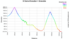
Just after the start from Serre-Chevalier the riders will climb the Col du Lautaret (15.5 km with an average climb of 4%, 2nd category) before they continue in the eastern direction to than go find the out of category climb of Chamrousse 1750 (17.5 km with an average climb of 5%) and finally descend towards the finish on the Boulevard Clémenceau in Grenoble.The riders will be able to sprint in Bourg d'Oisans, before getting some additional forces in the feeding zone in Les Sables, and again sprinting in Vaulnaveys-le-Bas.
- You can find local information about this stage on:
> the site of Serre-Chevalier
> the site of Grenoble
Below you can find the time- and route schedule, the stage profile and the route of this stage on Google Maps. Click on each of the images to open it.


6/ Crolles > Alpe d'Huez - 151.5 km
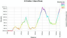
On Saturday 12 June 2010 the stage which can be seen as the queen stage of this Critérium du Dauphiné 2010 will start in front of the Espace Paul Jargot in Crolles (the riders will than follow the Rue François Mitterand, the Rue Léo Lagrange, the Rue Hector Berlioz, the Avenue de l'Abbaye, the Avenue Joliot Curie, the Avenue de la Résistance before arriving at the real start on the D1090) and continue with the climb of the Côte des Fontaines (3rd, 2.5 km with an average climb of 6.2%) but most importantly the Col du Grand Cucheron (18.5 km with an average climb of 4.4%, 2nd category), the Col du Glandon (out of category, 19.5 km with an average climb of 7.2%) and of course the final climb with its mythical 21 hairpin bends, the Alpe d'Huez (also out of category, 13.8 km with an average climb of 7.9%) on top of which a good climber will take the stage victory and maybe also take an option on the final win in this 62nd edition of the Critérium du Dauphiné!Before this victory, the riders will find the feeding zone in La Girard and the two intermediate sprints in Saint-Etienne-de-Cuines and in La Paute.
- You can find local information about this stage on:
> the site of the city Crolles with a very good description of the stage
(on Alpe d'Huez' site there's only the official press file)
Below you can find the time- and route schedule, the stage profile and the route of this stage on Google Maps. Click on each of the images to open it.


7/ Allevard-les-Bains > Sallanches - 148 km
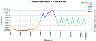
The very last stage has a relatively flat profile in the first 50 kilometers after the start in Allevard-les-Bains before starting the climb of the Côte des Rafforts of the 2nd category (11.2 km with an average climb of 5,2%). In Praz-sur-Arly the riders will find the first intermediate sprint before descending to Sallanches where they'll enter a circuit including the climb of the Côte de Domancy (3rd category, 2.4 km with an average climb of no less than 9.2%) which will be climbed 5 times before going back to the finish line in Sallanches for the last time and thus finish the 1080 kilometers of the Critérium du Dauphiné 2010!Just after the first crossing of the finish line, the feeding zone will be in Sallanches while at the 2nd crossing of the finish line, the riders can take the very last points for the classification by points.
Sallanches has always been very connected to cycling with a visit of the Tour de France in 1968 (stage finish, coming from Grenoble) and 2003 (stage start towards Alpe d'Huez), the France Championships in 1966, the Critérium du Mont Blanc, the Semaine Fédérale in 2003, the Rhône Alpes Championships in 2009, the Critérium du Dauphiné Libéré in 1999 (start, towards Aix-les-Bains), 2000 (finish, coming from Saint-Jean-de-Maurienne), in 2005 (finish, coming from Morzine-Avoriaz) and thus in 2010 without the word Libéré in the name. To this list we should of course add the World Championships in 1964 and in 1980. This last stage of the 2010 Critérium du Dauphiné will celebrate the 30 years of the last one and since Bernard Hinault was the winner after a superb solo (see video below), the current ASO employee will most probably be very much in the picture.
Will one of the riders of the 2010 Critérium du Dauphiné also attack in one of the climbs of the Côte de Domancy?
- You can find local information about this stage on:
> the site of Allevard-les-Bains
> the mini-site for Sallanches which mainly contains historical information
Below you can find the time- and route schedule, the stage profile and the route of this stage on Google Maps. Click on each of the images to open it.


The 2010 Critérium du Dauphiné route downloadable in Google Earth
Above you have discovered all details about all stages of this 62nd Critérium du Dauphiné including especially the time- and route schedules, the stage profiles and for each of them the route on Google Maps.If you want to check out all stages of the 2010 Critérium du Dauphiné at once, you can download the file below to open it in Google Earth.
>> Download the 2010 Critérium du Dauphiné route in Google Earth
This file will not only allow you to see the full route in Google Earth, but also to do a virtual fly-over over the route of one or more of the stages. To do so, you can of course use the default settings of Google Earth, but if you want to do a fly-over which really gives you the idea you were on your bike riding on the roads of the 2010 Critérium du Dauphiné, I recommend you the following settings: in the menu Tools > Options choose the tab Touring and fill in the following choices on that tab:
- Camera tilt angle : 80.0 degrees
- Camera range : 150.0 meters
- Speed : 500.0 (if this makes you feel dizzy or if your computer or Internet connection don't allow you to get clear images with these settings, you can try lowering the speed) door Thomas Vergouwen
Vond u dit artikel interessant? Laat het uw vrienden op Facebook weten door op de buttons hieronder te klikken!
2 comments | 20488 views
this publication is published in: Criterium du Dauphiné | OpenStreetMap/Google Maps/Google Earth | UCI ProTour | Critérium du Dauphiné 2010


 by marco1988 over
Merci Thomas
L'article était passé à travers les mailles du filet
http://www.cyclisme-roltiss-over.com/article-le-parcours-du-criterium-du-dauphine-2010-sur-google-maps-google-earth-et-les-itineraires-horaires-51760089.html
A +
Roland
Je publie cette information concernant le prochain Dauphiné ici.
Dans Le Progrès de ce matin (09/02/2011), la Une faisait objet d'un départ d'une étape du critérium de Villars-les-Dombes le 10 juin prochain. Cette petite ville (située à mi-chemin entre Bourg-en-Bresse et Lyon), connue pour son Parc des Oiseaux où aura lieu le départ (vaste parking + accueil spectateurs), donne souvent le départ d'une étape du Tour de l'Ain (en aout prochain), très belle course avec de beaux coureurs (victoire de Zubeldia l'an passé) mais qui ne connait pas une médiatisation énorme (même au niveau régional). Ce sera l'occasion de faire parler du Parc des Oiseaux et du Tour de l'Ain lors de cette étape arrivant normalement en montagne (mais ASO n'a pas divulgué la ville-arrivée) avec une possible retransmission télévisée. Enfin le plus haut niveau mondial dans le département (autre que Bourg-en-Bresse et un départ-arrivée du Tour de France en 2007 et une petite excursion dans la Bresse en 2010), l'Ain est une vraie terre cycliste avec des personnes passionées.
A quand le Tour de France au Parc des Oiseaux ?
Bonne soirée
Elie