The first race of the UCI World Tour 2011 is, as usual now since a few years, the Tour Down Under.
As in previous years, www.velowire.com will continue in 2011 to offer you the race routes on Google Maps / in Google Earth for the main cycling races. The first race route for 2011 is the one for the Tour Down Under 2011 which you'll discover in this article!
The Tour Down Under 2011 will take place from Tuesday 18 until Sunday 23 January 2011 (and not from 16 January as we can read at some places; on 16 January the Cancer Council Classic will be organised and this "criterium" is not officially part of the Santos Tour Down Under on the UCI World Tour 2011 calendar; since the organisation presents it as a preview on the official race and since the same riders participate in it, I integrate it anyway in the presentation of the race routes below) around Adelaide in South-Australia.
Sunday 16 January 2011 - Cancer Council Classic - Adelaide - 51 km
 As usual, the Tour Down Under 2011 starts with the Cancer Council Classic, some kind of prologue befor the 6 stages which will start the upcoming Tuesday. After having been renamed Cancer Council Helpline Classic for one year, this stage is now again called Cancer Council Classic thanks to the partnership with Cancer Council SA (the South-Australian organisation which gives tips to reduce the risk on cancer and helps in finding an efficient threatment for patients).
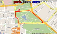
A closed 1.7 kilometer long circuit around the Rymill Park will form the completely flat race route for this classic. The riders will do this circuit 30 times to get to a total distance of 51 kilometers. The start is planned at 6.45PM for a finish around 8PM.
At the 5th, 10th, 15th and 20th crossing of the finish line the riders can win primes during a sprint.
As you can see to the right, the jersey for the winner hasn't changed compared to last year.
CONTINUE READING AFTER THIS ADVERTISEMENT
The race route (Google Maps) and the profile of the Cancer Council Classic


1/ Tuesday 18 January 2011 - IG Markets Stage 1 - Mawson Lakes > Angaston - 138 km
On Tuesday 18 January, the Tour Down Under 2011 will really start with the first stage from Mawson Lakes (start at 11AM, The Boulevard) to Angaston (finish around 2.29PM).This first stage is one of the three stages which are named by their sponsor, IG Markets. IG Markets provides online trading services in CFDs (Contracts for Difference) and makes a bright entrance in the cycling world. Indeed, on 18 November 2010 already, IG Markets announced it would become official partner of Team Sky. In 2011 we'll thus see the name IG Markets showing up on the collar of the jersey and on the back of the bibshorts of the British team. After having decided to sponsor stages 1 and 2 of the 2011 Tour Down Under, the Tour Down Under 2011 organisation announced on 5 January that the company finally also sponsors the 6th stage of the Tour Down Under 2011.
Let's go back to the details of this stage ... After the start at about 15 kilometers from Adelaide, the riders will find the first climb of this Tour Down Under 2011 after less than 12 kilometers in the race, at the Black Top Road in Hillbank. Halfway in between Mawson Lakes and Angaston, the first sprint will be in Sandy Creek and less than 7 kilometers further we'll already see the second sprint, in Lyndoch.
In Tanunda the riders will get on the circuit which will be run twice. At the first crossing of the finish line in Angaston (after 80 kilometers in the race) the riders will be able to get some food in the feeding zone. The finish line will be drawn on Murray Street.


2/ Wednesday 19 January 2011 - IG Markets Stage 2 - Tailem Bend > Mannum - 146 km
The second stage will start in Tailem Bend, at a little bit less than one hundred kilometers south east from Adelaide, and will go towards Mannum, about 50 kilometers north. The stage will however do a loop visiting Kanmantoo where the first sprint (after 53.3 km) will take place, the climb of Dawesley Hill and Charleston where the riders will get in the feeding zone. Their trip will continue north up to Mount Pleasant where they will battle for the second sprint before continuing east towards the finish in Mannum.

3/ Thursday 20 January 2011 - Colemans Group Stage 3 - Unley > Stirling - 129 km
Last year already, the 3rd stage connected Unley to Stirling and this year this will again be the case.Up until the sprint in McLaren Flat the race route will be exactly the same, but instead of continuing towards the climb of Wickham Hill Road, the riders will continue north this time, towards Kangarilla, before they get back on the same race route as last year in Meadows. In Echunga they'll find the second sprint and while the final loop around Stirling is the same, they'll not immediately get on it but visit Hahndorf and the climb of Germantown Hill in Bridgewater first.


4/ Friday 21 January 2011 - Mutual Community Stage 4 - Norwood > Strathalbyn - 124 km
While last year the 4th stage connected Norwood to Goolwa over 149.5 km, this year it will go from Norwood to Strathalbyn over 124 kilometers. The end of the neutralised zone will be in Athelstone and the only climb of the day will be in Kersbrook with the Checker Hill. 2 sprints are on the programme: after 33 kilometers in Gumeracha and a little bit less than 30 kilometers further close to Balhannah. The feeding zone will be in Macclesfield and the riders will than directly continue towards the finish in Strathalbyn without a local circit at the end.

5/ Saturday 22 January 2011 - Jayco Stage 5 - McLaren Vale > Willunga - 131 km
The race route of this stage is exactly the same as for the Snapper Point > Willunga stage last year. Indeed, this year again it will be made up of two circuits: the first one which starts in McLaren Vale and which continues at the finish in Willunga while getting back to McLaren Vale through Snapper Point, Port Willunga and Aldinga and a second circuit around Willunga.The riders will do the first circuit twice entirely and the part towards Willunga three times. After the first and the second round they can grab some points during the intermediate sprints in Snapper Point.
They'll finish off the stage with two rounds on the second circuit which contains the Willunga Hill which will award points for the King of the Mountain jersey twice.


6/ Sunday 23 January 2011 - IG Markets Stage 6 - Adelaide City Council Street Circuit - 90 km
As usual, the last stage will be on a circuit in the center of Adelaide. The circuit is 4.5 km long and will be done 20 times to come to a total distance of 90 kilometers (start at 1.15PM).At the 8th and 12th round, the riders will sprint on the finish line while in the 10th and 15th round they can win the last points for the King of the Mountains jersey on a tiny climb which is called Montefiore Hill.
The finish is planned around 3.15PM.


The 2011 Tour Down Under race route in Google Earth
If you would like to see the full race route of all stages of the Tour Down Under 2011 in Google Earth you can (after having installed Google Earth if necessary) click on the following link:> Download the 2011 Tour Down Under race route in Google Earth

This file will not only allow you to visualise the full race route in Google Earth but also to do a virtual fly-over on one or each of the stages. door Thomas Vergouwen
Vond u dit artikel interessant? Laat het uw vrienden op Facebook weten door op de buttons hieronder te klikken!
1 comment | 6279 views
this publication is published in: Tour Down Under | Tour Down Under 2011 | OpenStreetMap/Google Maps/Google Earth


 by marco1988 over
http://www.cyclisme-roltiss-over.com/article-le-parcours-du-santos-tour-down-under-2011-google-maps-google-earth-64742860.html