Saturday 16 April 2011 at 16h44
Tomorrow the Dutch classic, the Amstel Gold Race, will take place between Maastricht and the Cauberg in Valkenburg.
The Amstel Gold Race 2011 race route has been very slightly modified compared to last year and a second climb of the Geulhemmerberg brings the total number of climbs to 32 instead of 31 on the race route of this UCI WorldTour race. In this article you'll find the time and route schedule, the race route on Google Maps and you can download the race route in Google Earth so you could for example make a virtual fly-over.
CONTINUE READING AFTER THIS ADVERTISEMENT
The description of the race route
After the start from the Markt in Maastricht the riders will first go north via the Maasberg up to Urmond where they will cross over to Geleen before following up the climbs of the Adsteeg, Lange Raarberg, Bergseweg, Sibbergrubbe, Cauberg, Geulhemmerweg, Wolfsberg, Loorberg, Schweiberg (Schweibergerweg), Camerig, Drielandenpunt, Gemmenich, Vijlenerbos, Eperheide, Gulpenerberg, Plettenberg (van Plettenbergweg), Eyserweg, Sint Remigiusstraat - Huls, Vrakelberg, the second climb of the Sibbergrubbe, the second climb of the Cauberg, the second climb of the Geulhemmerberg, Bemelerberg, the second climb of the Wolfsberg, the second climb of the Loorberg, the second climb of the Gulpenerberg, Kruisberg, the Eyserbosweg, Fromberg, Keutenberg and finally the third climb of the Cauberg where they'll cross the finish line for the last time.The start will be at 10.15AM and the finish is planned for around 4.51PM. The total distance will be 2.6 kilometers longer with 260.4 kilometers.
The route- and time schedule, the profile and the race route in Google Maps
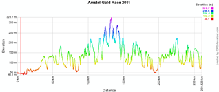
Below you'll find a Google Maps map with the race route, the profile and the route- and time schedule (with the times the riders will pass the different villages and cities on the race route) of the Amstel Gold Race 2011. Click on the images to open them:


CONTINUE READING AFTER THIS ADVERTISEMENT
The Amstel Gold Race 2011 race route in Google Earth
Do you prefer to watch the race route in Google Earth and for example do a virtual fly-over of the race route? Download the KML file below:> Download the Amstel Gold Race 2011 race route in Google Earth
This file will not only allow you to visualise the whole route in Google Earth but also to do a virtual fly-over over the route. To do so, you can of course use the default configuration for Google Earth, but if you would like to do a virtual fly-over as if you were riding on the roads of the Amstel Gold Race 2011, I would recommend the following settings: in the menu Tools > Options choose the tab Touring and fill in the following choices on that tab:
- Camera tilt angle : 80.0 degrees
- Camera range : 150.0 meters
- Speed : 500.0 (if this makes you feel dizzy or if your computer or Internet connection don't allow you to get clear images with these settings, you can try lowering the speed) door Thomas Vergouwen
Vond u dit artikel interessant? Laat het uw vrienden op Facebook weten door op de buttons hieronder te klikken!
4 comments | 9871 views
this publication is published in: Classics | OpenStreetMap/Google Maps/Google Earth


 by marco1988 over
Itinéraire horaire??? Il y a les km, mais pas les heures;...
Oops! Je n'avais pas mis la bonne version du fichier ... maintenant il y a les heures aussi :-). Heureusement il y en a qui font attention !
Le pire c'est que je ne pourrai même pas voir la course en direct :-(
Ik zie het tijdschema niet, voor de rest leuke sight.
Mvg.,johan
Bedankt Johan! Het tijdschema is te vinden onder de knop "itinéraire horaire"