Friday 12 August 2011 at 23h20
A few days ago I presented you the different stage races which are on the UCI cycling calendar in August in France and especially the the Tour Poitou-Charentes 2011 race course on Google Maps.
These stage races are alternated with 3 one day races including the Châteauroux Classic de l'Indre Trophée Fenioux on the Sunday after the Tour du Limousin and the Grand Prix de Plouay the next Sunday, after the Tour Poitou-Charentes. In this article you can find all details about the race course of these two races on Google Maps and with the profiles.
CONTINUE READING AFTER THIS ADVERTISEMENT
The Châteauroux Classic de l'Indre Trophée Fenioux 2011 race course on Google Maps
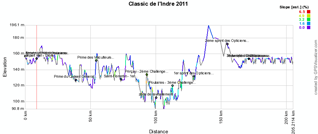
The race, which has its 8th edition since its creation in 2004, covers with its race route the whole north-eastern part of the Indre department which gives its name to the race. It will start in Châteauroux and go towards Issoudun where the Prime du Conseil General de l'Indre will be awarded and than to Reuilly with the Prime des Viticulteurs de Reuilly and Vatan for the first out of 3 Challenges Citroën in Saint-Florentin, but also in Prinçay and Poulaines. The riders will get in the feed zone between the last two, between Dun-le-Poëlier and Saint-Christophe-en-Bazelle. The riders will than get back to Vatan where the first sprint des Opticiens Mutualistes will take place before they continue south-west towards the second of these 3 sprints in Vineuil. Via Déols they'll get back to Châteauroux where they arrive on a 7.4 kilometer long circuit on which they will race 5 laps. In this circuit they'll have a new feeding zone in the Rue Ampère.
Below you can find the time- and route schedule, the profile and the race course on Google Maps kaart for the Classic de l'Indre 2011. Click on the images to open them.


>> Download the Classic de l'Indre 2011 race course in Google Earth
The Grand Prix de Plouay 2011 race course on Google Maps
The Grand Prix de Plouay 2011 will take place on 28 August, just after the Tour Poitou-Charentes, and as a UCI WorldTour race it will receive the 18 UCI ProTeams (Team HTC-Highroad, Garmin-Cervélo, Lampre-ISD, Astana, AG2R La Mondiale, Movistar Team, Omega Pharma-Lotto, BMC Racing Team, Katusha Team, Euskaltel-Euskadi, Rabobank, Team Sky, Team Leopard-Trek, Liquigas-Cannondale, Quickstep, Vacansoleil-DCM Pro Cycling Team, Team Radioshack, Team Saxo Bank-Sungard) but also some French teams: FDJ, Bretagne-Schuller, Cofidis, Team Europcar and Saur-Sojasun and the Dutch Skil-Shimano team.The race, which has its 75th edition since its creation in 1931, takes place on a circuit which was also used for the
The day before, the same circuit will be used, for 6 laps, for a youth race (the GP de Plouay Trophée GMB) and for the Grand Prix de Plouay ladies which is part of the UCI Worldcup.
Who will follow up on the Australian Matthew Goss to sprint for victory in this UCI WorldTour race? We'll discover that in the weekend of 27 and 28 August in Plouay!
Below you can find the profile and the race course on Google Maps for the Grand Prix de Plouay 2011. Click on the images to open them.


>> Download the Grand Prix de Plouay 2011 race course in Google Earth door Thomas Vergouwen
Vond u dit artikel interessant? Laat het uw vrienden op Facebook weten door op de buttons hieronder te klikken!
3 comments | 5051 views
this publication is published in: Grand Prix de Plouay | Classic de l'Indre | OpenStreetMap/Google Maps/Google Earth


 by marco1988 over
The link for the Google Earth file of Grand Prix de Plouay 2011 is broken, it says 'Page non trouvée'. Can you fix it, please, if you still have the file? Thanks for the good work.
Hello,
Should be working OK again now :).
Thank you, it works great now.