tuesday 27 March 2012 at 23h56
This morning in Lyon, the race route of the Critérium du Dauphiné 2012 has been officially presented by ASO. In 2008, I already said of this race in June that it's a mini Tour de France and that's still the case for the 2012 edition!
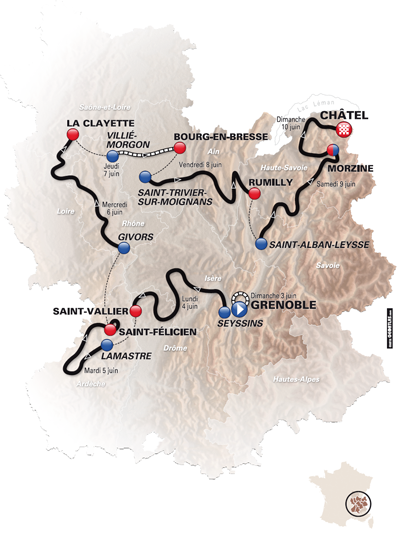
In this article you'll find the first information about the 7 stages and the prologue which form, with 1,052 kilometers, the race route of this 64th edition which visits the Grand Colombier for the first time since 24 years ... however, it is already criticised because it is too far from the stage finish in order for this climb to be decisive!
CONTINUE READING AFTER THIS ADVERTISEMENT
The stages of the Critérium du Dauphiné 2012
While the Critérium International just ended with a victory of Cadel Evans, we now go on with a short presentation of the stages of another criterium, the Critérium du Dauphiné: a race composed of a prologue and 7 stages of which 6 in line and a 53 kilometers long time trial. The stages are as follows:| # | type | date | start | finish | distance |
|---|---|---|---|---|---|
| P | prologue | Su. 3 June 2012 | Grenoble | 5.7 km | |
| The Critérium du Dauphiné 2012 starts, as usual, with a prologue, over a distance of 5.7 kilometers. This will be at the same location as the 42,5 kilometer long time trial in the Dauphiné last year and which was also the forelast stage of the Tour de France 2011, Grenoble. This time however the time trial will be much shorter and will give the first times in this 64th edition of the Critérium du Dauphiné. | |||||
| 1 | in line | Mo. 4 June 2012 | Seyssins | Saint-Vallier | 187 km |
| There's not much information available yet about this first stage in line but it should be a quite hilly stage already with several short climbs including one just before the finish in Saint-Vallier, 187 kilometers after the start in Seyssins. | |||||
| 2 | in line | Tu. 5 June 2012 | Lamastre | Saint-Félicien | 160 km |
| The second stage is even more hilly with a climb of the Col de Montivernoux (2nd category) which starts right from the start in Lamastre and which has its summit at kilometer 45. The riders continue the ascent towards the Mont Gerbier de Jonc 101 meter higher and 9.5 kilometers further but this is not part of the KOM classification. After the descent they'll follow-up the Col de Clavière (2nd category), Col de Rochepaule (3rd) and the Col de Lalouvesc (2nd) followed after the descent by a short climb towards the top of the Col de Fontaille (4th) and finally a climb, 4th category as well, towards the finish in Saint-Félicien, the place where the cyclosportive L'Ardéchoise usually finishes. 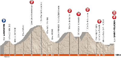 | |||||
| 3 | in line | We. 6 June 2012 | Givors | La Clayette | 167 km |
| The 3rd stage should be pretty flat and this stage should thus most logically have a sprint finish. | |||||
| 4 | individual time trial | Th. 7 June 2012 | Villié-Morgon | Bourg-en-Bresse | 53 km |
As usual a long time trial will be programmed in the middle of the race, this year on an almost flat route between Villié-Morgon and Bourg-en-Bresse.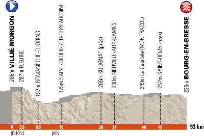 | |||||
| 5 | in line | Fr. 8 June 2012 | Saint-Trivier-sur-Moignans | Rumilly | 186,5 km |
| This 5th stage announces the arrival of the high mountains, especially with the Grand Colombier, hors category, and surrounded by the Côte de Corlier and the Col de Richemond, but which has its summit at about 70 kilometers from the finish! ASO already got criticised for having included this col, for its very first climb in the Tour de France 2012, at about 40 kilometers from the finish, in Bellegarde-sur-Valserine, but this is even worse and it's thus most probable that this climb will have no influence at all on the result of this stage. 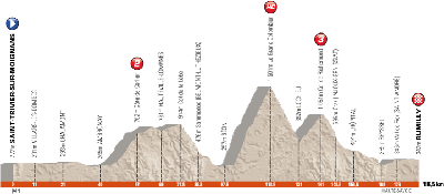 | |||||
| 6 | in line | Sa. 9 June 2012 | Saint-Alban-Leysse | Morzine | 166.5 km |
| The forelast stage is really made for climbers since after the start in Saint-Alban-Leysse, they'll have to climb no less than 6 climbs in this stage which finishes in Morzine. Right from the start they'll start with the climb of a first category col, the Col de Plainpalais, followed by the Col de Leschaux (3rd), a flat part and the Col des Essérieux (3rd) which goes on in the climb of the Col de la Colombière (1st). After the descent, the stage continues with a short climb, of the Côte de Châtillon-sur-Cluses, followed by the decisive Col de Joux-Plane, hors category. After the descent of this climb the riders will finish this 6th stage and we should start to get a good idea on who might be the future winner of the Critérium du Dauphiné 2012. 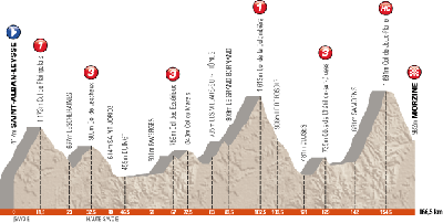 | |||||
| 7 | in line | Su. 10 June 2012 | Morzine | Châtel | 126 km |
| The last stage is short but not easy ... A follow-up of climbs (Côte de Mijouet - 4th category, Col de Cou - 3rd and the Côte de la Vernaz - 2nd category) precede the climb of the Col du Corbier (1st category) of which the summit is at 23 kilometers from the finish, finish which will be uphill in Châtel on a 3rd category climb. At the end of this stage we'll know who will follow up on Bradley Wiggins as the winner of this race! 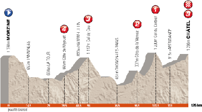 | |||||
Vond u dit artikel interessant? Laat het uw vrienden op Facebook weten door op de buttons hieronder te klikken!
7 comments | 8053 views
this publication is published in: Criterium du Dauphiné | Critérium du Dauphiné 2012


 by marco1988 over
je replace mon commentaire ici car plus pratique ;).
C'est du tout au...tout. L'an passé ASO blindait avec 4 arrivées au sommet, un parcours un peu trop dur pour un Dauphiné (combien de cols déjà?), maintenant ils nous sortent un tracé qui glisse sur du velours. C'est pas dégueu mais il y a matière à faire 20 fois mieux.
Je me suis dit "Ils ont voulu mettre Rumilly pour inclure le col de la Biche". Et non, même pas, c'est le Richemont avec 40 bornes derrière... Quand je vois que des bleds comme Seyssins, St Félicien ou encore La Clayette sont villes-étapes, je me dit pourquoi ne pas arriver à Seyssel en bas du col de la Biche? La question peut se poser pour le Tour de France également.
Une arrivée au sommet du Grand Colombier n'aurait pas été de refus, le Tour de l'Ain le fait bien. Même si, effectivement, le Dauphiné, c'est autre chose. Pareil pour Morzine, Joux-Plane c'est super mais j'aurais aimé voir Avoriaz derrière, surtout avec le profil de l'étape de la veille!
Le chrono, c'est pour préparer au Tour, il sera long, donc on prévoit long! Je m'attendais à ça.
On m'avait dit que l'étape de St Félicien suivait le parcours de l'Ardéchoise. OK mais on m'avait pas prévenu que se serait un parcours long de 160 kms!^^ Une broutille je m'attendais à voir le "circuit long" de 230 bornes. La farce!
On verra bien ce que cela donnera mais le parcours est calqué sur celui du Tour un mois plus tard.
Voilà bonne journée!
Je ne suis pas vraiment d'accord avec votre commentaire . Pour bien connaître la région , le parcours n'est pas si facile que ça . Le chrono fera des écarts car le parcours est vallonné avec des petits coup de cul de 600/700 m et il y aura du vent de face sur la partie finale ( une route presque droite pendant 20 km ). C'est vrai que l'on peut faire toujours mieux , mais il faut diversifier les tracés d'une année sur l'autre .
Cordialement ,
il y avait largement de quoi faire mieux pour avoir un bon parcours :
un prologue en côte sur les pentes de la Bastille à Grenoble (déjà fait dans le passé)
suppression de la boucle à Saint-Félicien qui éloigne le dernier col de l'arrivée, et rajouter quelques cols pour rallonger l'étape
le Col de la Biche (beaucoup plus dur que Richemond) après le Grand Colombier pour avoir 20 km de plat pour rejondre Rumilly au lieu de 40
ajout de la montée d'Avoriaz pour avoir une arrivée en côte, en plus la montée n'est pas très dure donc les grimpeurs attaqueraient quand même dans Joux Plane
arrivée à Chatel par la Suisse et le Pas de Morgins
Le parcours du prologue de grenoble est il connu?
@corti : à ma connaissance pas encore ...
Ok, merci
Je reviens ici pour le clm qui pose d'énormes problèmes de gestion de la circulation routière puisqu'il traverse l'ex RN 6 et les forces de l'ordre se sentent capables de laisser passer le trafic entre 2 coureurs qui s'élancent de minute en minute.
Je vous laisse imaginer le cirque, alors qu'en déplaçant le départ dans le département de l'Ain, tout le monde était tranquille.
On l'a déjà vu avec le tracé du Tour 2012, les organisateurs ne se soucient pas vraiment de ce qui se passe autour, et c'est aux autorités locales de se débrouiller avec.
Mais je vois mal un prefet ou un PCG dire non à ASO.