Thursday 12 April 2012 at 08h16
This weekend, there will not only be the Amstel Gold Race 2012 which is on the UCI cycling calendar. There will be two other races, which are both part of the Coupe de France PMU (after the Grand Prix de Denain today, it will be the 8th and 9th race of this competition made up of 16 one day races): the Tour du Finistère on Saturday and the Tro Bro Leon on Sunday.
In this article, you can discover the detailed race route of the Tour du Finistère 2012 on Google Maps, just like the time- and route schedule, the profile of the race and the possibility to download the race route in Google Earth.
CONTINUE READING AFTER THIS ADVERTISEMENT
The Tour du Finistère 2012 on Google Maps
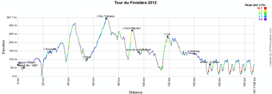
The Tour du Finistère 2012 will start from the most western point of the Parc naturel régional d'Armorique in the Finistère, in Crozon for a race of 186.1 kilometers.The race visits a big part of this parc naturel régional via 4 sprints/climbs which count for the Trophée Crédit Agricole of the race, in Rosnoën, Sizun, on top of the Roc Trédudon and the Roch Béghéor. At the exit of the parc naturel régional, the riders can get some energy in the feeding zone before they continue north until the top of the next climb in Laz. From there, they'll turn north-west towards the first crossing of the finish line. Before that, they'll get to the 6th and last sprint in Waterloo.
After the first crossing of the finish line in the Rue de Stang Bihan in Quimper, they'll still have to do 4 laps of a 8.7 kilometer long circuit north of the city.
Hereunder you'll find the race route on Google Maps, the profile and the time- and route schedule of the Tour du Finistère 2012. Click on the images to open them.


The race route of the Tour du Finistère 2012 in Google Earth
Do you prefer to watch the race route in Google Earth and for example do a virtual fly-over of the race route? Download the KML file below to do so:> Download the race route of the Tour du Finistère 2012 in Google Earth
This file not only allows you to see the whole race route in Google Earth but also to do a virtual fly-over of it. In order to do so, you can use the default configuration as suggested by Google Earth, but if you prefer to do a fly-over which gives you the idea you're riding on the roads of the Tour du Finistère 2012, I'd recommend you the following configuration: in the menu Tools > Options choose the tab Touring and fill in the following choices on that tab:
- Camera tilt angle : 80.0 degrees
- Camera range : 150.0 meters
- Speed : 500.0 (if this makes you feel dizzy or if your computer or Internet connection don't allow you to get clear images with these settings, you can try lowering the speed) door Thomas Vergouwen
Vond u dit artikel interessant? Laat het uw vrienden op Facebook weten door op de buttons hieronder te klikken!
1 comment | 6688 views
this publication is published in: Tour du Finistère | OpenStreetMap/Google Maps/Google Earth | Coupe de France


 by marco1988 over
http://www.les-actus-du-cyclisme.fr/article-tour-du-finistere-2012-le-parcours-sur-google-maps-l-itineraire-horaire-et-le-profil-103276735.html