Friday 13 April 2012 at 09h32
As announced in the previous article, this weekend will not only see the Amstel Gold Race taking place on Sunday, but also the Tour du Finistère on Saturday and the Tro Bro Léon on Sunday!
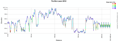
For the last mentioned race you can find in this article the race route on Google Maps, the time- and route schedule, the profile and the possibility to download the race route to open it in Google Earth.
CONTINUE READING AFTER THIS ADVERTISEMENT
The Tro Bro Léon 2012 on Google Maps
The Tro Bro Léon is a kind of a bis repetita of Paris-Roubaix. Indeed, where the second part of the race route of the Hell of the North is full of cobble stones, in the Tro Bro Léon it's the ribins which make the race particular.The ribins? I hear you say ... yes, yes, the ribins (pronounce: reebeens) or ribinous are small paths crossing a field, either a sand path but often with gravel, which are part of the race route of this race. No less than 22 ribins are on the race route, one of which will be done 4 times in the laps on the local circuit around the finish city, over a total distance of 33.4 kilometers.
The start and finish are in Lannilis, north of Brest. From there, the riders will first go towards the coast line to get to the real start of the race, in L'Aber Wrac'h. After the start they'll return to Lannilis and get to the intermediate sprint in Ploudalmézeau. They'll continue onto the ribins:
| # | place | length | from | to | km done | km to do |
| 01 | Plouarzel | 1,200 m | Langoulouman | Les Eoliennes | 46 | 160.4 |
| 02 | Milizac | 1,700 m | Coatquennec | Route de Milizac-Keralan | 59.5 | 146.9 |
| 03 | Bourg-Blanc | 2,100 m | Ty Douar | Kervalanoc | 68.8 | 137.6 |
| 04 | Plabennec | 2,400 m | Lanorven | Traon Bihan | 78.4 | 128 |
| 05 | St. Thonan | 1,000 m | Lanvelar-vihan | Mestallic / St. Thonan | 89.2 | 117.2 |
| 06 | St. Thonan | 1,500 m | Dourguen | Creac'h Coadic | 92.3 | 114.1 |
| 07 | Ploudaniel | 3,200 m | Kerbilbren | Kermahellan Braz | 100.5 | 105.9 |
| 08 | Lanarvily | 800 m | Loscoat | Loscoat | 113.3 | 93.1 |
| 09 | Kernilis | 700 m | Le Vern | Toul-Douar | 116.3 | 90.1 |
| 10 | Kernilis | 1,600 m | Le Clos | Penmarc'h | 119.8 | 86.6 |
| 11 | Le Folgoët | 1,200 m | Quiquelleau | Lannuchen | 122.5 | 83.9 |
| 12 | Plounéour-Trez | 1,200 m | Route de Plounéour-Trez | Gare de Plounéour-Trez | 135 | 71.4 |
| 13 | Kerlouan | 1,200 m | Neiz Vran | Treseny | 147.2 | 59.2 |
| 14 | Guissnény | 1,500 m | Lanveur | Kervaro | 160.8 | 45.6 |
| 15 | Plouguerneau | 1,800 m | Enez Inoc | Sainte Anne | 163.7 | 42.7 |
| 16 | Plouguerneau | 1,000 m | Enez Cadec | Anteren | 166.5 | 39.9 |
| 17 | Plouguerneau | 2,000 m | Kerdélant | Lanebeur | 169 | 37.4 |
| 18 | Plouguerneau | 1,500 m | Lanebeur | Le Cosquer | 171.3 | 35.1 |
| 19 | Plouvien | 700 m | Kerarédeau | Kerabo | 175.7 | 30.7 |
| 20 | Lannilis | 1,400 m | Keradraon | Kerouartz | 180.6 | 25.8 |
| 21 | Lannilis | 900 m | Pouldu | Mesmeur | 183.3 | 23.1 |
| 22>25 | Lannilis | 700 m | Meshuel | Trouz ar c'hant | 188.6 | 17.8 |
Hereunder you'll find the race route on Google Maps, the profile and the time- and route schedule of the Tro Bro Léon 2012. Click on each of the images to open them.


The Tro Bro Léon 2012 race route in Google Earth
Do you prefer to view the race route in Google Earth and do a virtual fly-over of the race route? To do so, you can download the KML file below:> Download the Tro Bro Léon 2012 race route in Google Earth
This file not only allows you to see the whole race route in Google Earth but also to do a virtual fly-over of it. In order to do so, you can use the default configuration as suggested by Google Earth, but if you prefer to do a fly-over which gives you the idea you're riding on the roads of the Tro Bro Léon 2012, I'd recommend you the following configuration: in the menu Tools > Options choose the tab Touring and fill in the following choices on that tab:
- Camera tilt angle : 80.0 degrees
- Camera range : 150.0 meters
- Speed : 500.0 (if this makes you feel dizzy or if your computer or Internet connection don't allow you to get clear images with these settings, you can try lowering the speed) door Thomas Vergouwen
Vond u dit artikel interessant? Laat het uw vrienden op Facebook weten door op de buttons hieronder te klikken!
2 comments | 14967 views
this publication is published in: Tro Bro Léon | OpenStreetMap/Google Maps/Google Earth | Coupe de France


 by marco1988 over
http://www.les-actus-du-cyclisme.fr/article-le-parcours-du-tro-bro-leon-2012-sur-google-maps-google-earth-et-l-itineraire-horaire-103364062.html
et voila la 29e édition du tro revient quel bonheur de pouvoir les revoir passer la ligne d'arriver a lannilis pret du barbecue des jeunes agriculteurs