Saturday 26 May 2012 at 17h50
In a week from now, the race which is sometimes called a mini Tour de France (and is at least used by many riders to prepare the Tour), the Critérium du Dauphiné 2012 will start in Grenoble with a 5,7 kilometer long prologue.
After the Giro d'Italia which will have its final stage as an individual time trial in Milan tomorrow, this race will bring back the UCI WorldTour on the scene since this is the 16th race of this calendar.
Let's have a look at the different stages with the race routes on Google Maps/Google Earth, the time- and route schedules and the profiles of each of the stages.
The Critérium du Dauphiné 2012 race route on Google Maps
7 stages and a prologue will be on the programme of this 64th Critérium du Dauphiné between Grenoble and Châtel, over a total distance of 1,051.7 kilometers. ATTENTION: all the contents of this article are protected by the usual copyright and you are thus not allowed to use the contents or parts of it without my prior approval. This concerns all texts, images and KML files. The KML files can in no case be used without the velowire.com logo and a link to this site in addition to my prior approval for you to use it.
CONTINUE READING AFTER THIS ADVERTISEMENT
P/ Sunday 3 June 2012 - Grenoble - 5.7 km
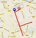
It thus all starts with a prologue in the streets of Grenoble. Even though the start and finish places are not really surprising since they are exactly the same as for the time trial of the Critérium du Dauphiné 2011 which was exactly the same as in the Tour de France 2011, the roads followed in between are a little bit more surprising.Indeed, after the start in the Avenue Jean Perrot in Grenoble the riders will go down this road until the Place Jean Racine where they'll turn around and go back on the same road for about 1 kilometer. They'll than turn right in the Avenue des Jeux Olympiques where they'll again turn around, on a roundabout this time, to turn right again back on the Avenue Jean Perrot. While approaching the start they'll finally turn right in the Boulevard Clémenceau where they'll end their solo effort.
Hereunder you'll find the time- and route schedule, the stage profile and its race route on Google Maps for this stage. Click on the images to open them.


1/ Monday 4 June 2012 - Seyssins > Saint-Vallier - 187 km
The first stage in line of the Critérium du Dauphiné 2012 will start in Seyssins just outside the city of Grenoble. After the start in the Rue Joseph Moutin, the riders will follow the Avenue des Grands Champs, the Avenue de Grenoble, the Rue de l'Agneau and the Avenue de la Poste where they'll leave Seyssins. In Seyssins-Pariset they'll than follow the Avenue Hector Berlioz, the Avenue du Vercors and the D1532 to the Boulevard Paul Langevin in Fontaine and finally the Avenue de Romans and the Avenue de Valence (D1532) where the real start will be at 9.3 kilometers from where the peloton started the ride.They'll than follow a race route which was made to go find different climbs. First of all they'll go north via the Col de Parménie (2nd category) and the Côte de la Poulardière (4th) before they go back south via the feeding zone in Marcilloles looking for the Côte de Chambaran (3rd) and the non referenced Col de la Madeleine to again go up north looking for the Côte des Escoffiers and the Côte des Potences, both 4th category.
Via Saint-Sorlin-en-Valloire they'll get close to the finish in Saint-Vallier. They'll however not get to this finish without having climbed the Côte de la Sizeranne (3rd category), which has its summit at 9 kilometers from the white line which will be drawn in the Avenue Eugène Buissonnet.
Hereunder you'll find the time- and route schedule, the stage profile and its race route on Google Maps for this stage. Click on the images to open them.


2/ mardi 5 June 2012 - Lamastre > Saint-Félicien - 160 km
The second stage in line of this Critérium du Dauphiné 2012 will take place between Lamastre and Saint-Félicien which is only 25 kilometers from there. With a race route which goes find its most southern point at the Col de Montivernoux (2nd category) before going back north via no less than 5 other climbs, this stage will however have a distance of 160 kilometers.The start in Lamastre will be on the Place Seignobos and the riders will turn right on the D533 (Rue Chalamet, Rue Raoul Follereau) and by keeping left they'll get onto the D578 where the real start will take place 2.6 kilometers from where they gathered together.
After the Col de Montivernoux the climb continues to the summit of the Mont Gerbier de Jonc which is however not referenced for the King of the Mountains classification. From there, the riders will descend to the feeding zone in Saint-Martin-de-Valamas before successively climbing the Col de Clavière (2nd category), Col de Rochepaule (3rd), Col de Lalouvesc (2nd) and the Col de Fontaille (4th). 22 kilometers further they'll cross the finish line which will be drawn at the end of a 300 meter long final straight line uphill on the D234 in Saint-Félicien (4th category).
Hereunder you'll find the time- and route schedule, the stage profile and its race route on Google Maps for this stage. Click on the images to open them.


3/ Wednesday 6 June 2012 - Givors > La Clayette - 167 km
Compared to the two previous stages, this 3rd stage in line of the Critérium du Dauphiné 2012 is not very difficult and would thus more correspond to a sprinters stage than to a climbers stage.Indeed, even though the stage starts uphill, the second half of the stage is flatter and will probably allow the peloton to catch up with any breakaway which would have been formed at the start of the stage.
The start will be on the Place Camille Vallin in Givors and the peloton will follow the Rue Roger Salengro in the opposite direction and than the Rue Robespierre, the Rue Pierre Semard and the Rue de Montrond. The real start will be on the D2 at 4.2 kilometers from the place where they started.
By going up north, they'll climb the Côte de Saint-André (3rd category), the Côte des Crêtes (4th) and the Côte de Vindry (4th) before they get in the feeding zone in Saint-Clément-sous-Valsonne. They will already have started the non referenced climb of the Col du Pilon at that time and the stage will end after that on a little bit hilly race route until the finish in the Rue de la Planchette in La Clayette next to the Grand Etang.
Hereunder you'll find the time- and route schedule, the stage profile and its race route on Google Maps for this stage. Click on the images to open them.


CONTINUE READING AFTER THIS ADVERTISEMENT
4/ Thursday 7 June 2012 - Villié-Morgon > Bourg-en-Bresse (ITT) - 53.5 km
As usual halfway the Critérium du Dauphiné, an individual time trial will take place this Thursday 7 June. The solo effort will take place on a west to east race route between Villié-Morgon (the start ramp will be placed in the Rue Baudelaire) and Bourg-en-Bresse (finish in the Avenue Maginot).The riders will start each minute, except for the last 20 riders who will start every two minutes.
There will be two intermediate timing points and one feeding zone close to Sulignat. With a positive height difference of only 440 meters, this time trial will probably allow a time trial specialist to win the stage.
Hereunder you'll find the time- and route schedule, the stage profile and its race route on Google Maps for this stage. Click on the images to open them.


5/ Friday 8 June 2012 - Saint-Trivier-sur-Moignans > Rumilly - 186.5 km
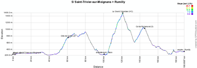
Back to the mountain stages with this 5th stage between Saint-Trivier-sur-Moignans and Rumilly. The first part of the stage, after the start from the Mavic company, is relatively flat after the climb of the Côte de Corlier (2nd category) (which goes on in the Col de la Lèbe, which is not referenced for the King of the Mountains classification) and the descent to the feeding zone in Béon, the riders will start the climb of the Grand Colombier (hors category).Even though this big col could be decisive in a stage, this will most probably not be the case in this stage because the summit of this climb is no less than 68 kilometers from the finish. Before they cross the white line in Rumilly the riders will climb the Col de Richemond (3rd category) but they'll still have more than 45 kilometers to go before they get to the finish line! The famous white line will be drawn in the Boulevard Louis Dagand.
Hereunder you'll find the time- and route schedule, the stage profile and its race route on Google Maps for this stage. Click on the images to open them.


6/ Saturday 9 June 2012 - Saint-Alban-Leysse > Morzine - 167.5 km
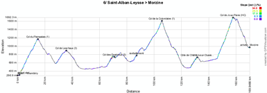
The forelast stage will have a bigger chance to see a climber become the stage winner because the race route contains no less than 2 first category climbs and 3 3rd category climbs, but also the climb of the Col de Joux-Plane (hors category) which will be separated from the finish line in Morzine only by the descent.From the Rue des Ecoles in Saint-Alban-Leysse the peloton will get to the real start via the Rue de la Pérrodière, the Rue des Barillettes and the Route de Féclaz and the kilometer 0 sign will be on the D912 at 3.3 kilometers from the start.
The riders will than immediately start the climb of the Col de Plainpalais (1st category) of which they'll find the summit after only 11.5 kilometers. After the descent of this col, they'll go on with the climb of the Col de Leschaux (3rd category) before they get on a flatter part of this stage.
After about 60 kilometers they'll start the climb of the Col des Essérieux (3rd category) which goes on in the non referenced Col du Marais. After the descent they'll get in the feeding zone in Les Villars-sur-Thônes before they start the climb of the Col de la Colombière (1st category). The descent of this col goes on in a short climb, the Côte de Châtillon-sur-Cluses (3rd category) and from Samoëns the riders will start the last climb of this stage, a hors category climb, the Col de Joux-Plane. Its summit will be at 12 kilometers from the finish and after the descente the future winner of this stage will thus directly go on to the finish on the Place de l'Office de Tourisme in Morzine.
Hereunder you'll find the time- and route schedule, the stage profile and its race route on Google Maps for this stage. Click on the images to open them.


7/ Sunday 10 June 2012 - Morzine > Châtel - 124.5 km
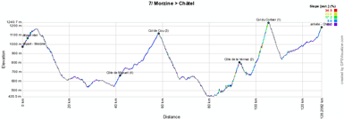
Even though it will be short, the very last stage of the Critérium du Dauphiné 2012 will not be completely easy either. Indeed, after the start from the Place de l'Office de Tourisme in Morzine, it will let the riders climb the Côte de Mijouet (4th category) which goes on in the Col de Cou (3rd).After the descent towards Thonon-les-Bains, the Côte de Vernaz (2nd category) and the Col du Corbier (1st) will follow each other before the stage ends with the climb towards Châtel. The finish will thus be uphill on the Route de Vonnes in Châtel.
Hereunder you'll find the time- and route schedule, the stage profile and its race route on Google Maps for this stage. Click on the images to open them.


The Critérium du Dauphiné 2012 race route in Google Earth
Would you like to see all stages of the Critérium du Dauphiné 2012 in a single view? That's possible! Indeed, you can download the KML file below and open it in Google Earth.>> Download the Critérium du Dauphiné 2012 race route in Google Earth

With this file you can not only watch the full race route in Google Earth but also do a virtual fly-over over one or more of the stages.
Let's no longer say Critérium du Dauphiné Libéré
Many of you continue to find velowire.com and more specifically this article by searching things like "Critérium du dauphiné libéré 2012 race route" or simply "dauphiné libéré 2012" in a search engine. Fortunately you find what you're looking for by searching this, but this 64th edition of this race is already the 3rd to have adopted the name Critérium du Dauphiné. Indeed, even though the newspaper which originally created the race is still called Dauphiné Libéré, the race has been organised by Amaury Sport Organisation since 2010 and this organisor has dropped the word "Libéré" from the name of the race at the same time.Therefore, no longer say Critérium du Dauphiné Libéré but simply say Critérium du Dauphiné, a pure concentrate of mountains!
The Critérium du Dauphiné 2012 on TV
Of course the Critérium du Dauphiné 2012 will be broadcasted on television. Hereunder you'll find the list of TV channels which you can watch in order not to miss anything of the race in case you can't come watch it live in France (only the channels which do live broadcasting have been mentioned):- in France: on France 3 on 3, 9 and 10 June from 1.30PM till 3PM and from 4 till 8 June from 3PM till 4.35PM; on Eurosport 2 on Thursday 7 June from 2.45PM till 4.30PM and on Friday 8 June from 3PM till 4.30PM and on Eurosport on Saturday 9 June from 1PM till 4.45PM and on Sunday 10 June from 2.15PM till 2.45PM
- in Spain on Teledeporte
- in Italy on Rai Sport
- in Luxembourg on RTL
- in Norway on TV2 Zebra
- on Eurosport International on Saturday 9 June from 1PM till 2.45PM and on Sunday 10 June from 2.15PM till 2.45PM
- outside of Europe: in Australia on SBS, in Japan on J Sports, in New-Zealand on Sky Sports, in several African countries on SuperSport and in several Asian countries on Eurosport Asia
Of course you'll also be able to regularly follow the race on velowire.com with race updates and summaries, results and many photos! door Thomas Vergouwen
Vond u dit artikel interessant? Laat het uw vrienden op Facebook weten door op de buttons hieronder te klikken!
3 comments | 19118 views
this publication is published in: Critérium du Dauphiné 2012 | Criterium du Dauphiné | OpenStreetMap/Google Maps/Google Earth


 by marco1988 over
http://www.les-actus-du-cyclisme.fr/article-criterium-du-dauphine-2012-le-parcours-sur-google-maps-earth-les-profils-et-les-itineraires-hora-105881731.html
Salut Thomas , ATTENTION , sur les horaires et cartes des étapes 5 et 6 ca met en titre d étape VILLIE MORGON - BOURG EN BRESSE ! A+++++ LISEROIS
Merci, c'est corrigé ! :-)