Friday 15 March 2013 at 01h34
After Paris-Nice last week, this weekend we'll see the usual duo of one day French races: the Classic Loire Atlantique on Saturday and Cholet-Pays de Loire on Sunday, respectively 2nd and 3rd race of the Coupe de France PMU which the first mentioned integrated last year.
In this article you'll find all details of these two races: the Classic Loire Atlantique, organised around La Haye-Fouassière, at about 15 kilometers south-east of Nantes, and Cholet-Pays de Loire which forms a lap around Cholet.
This weekend, velowire.com will be present in these two races and you'll thus find on this website all details, photos and results!
CONTINUE READING AFTER THIS ADVERTISEMENT
The map with the race route of the Classic Loire Atlantique 2013 on Google Maps/Google Earth
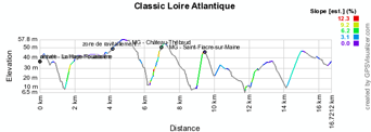
For the Classic Loire Atlantique there are no changes this year: as usual, the race will take place as 11 laps on a 16.8 kilometer long circuit.With start and finish in the Boulevard Bernard Verlynde in La Haye-Fouassière, the race will visit the villages Maisdon-sur-Sèvre, Château-Thébaud, Saint-Fiacre-sur-Maine and Vertou over a total distance of 184.8 kilometers.
The race will start at 12.30PM and should finish around 5.10PM. Watch the time- and route schedule.
Hereunder you'll find the profile and the race route of this race on Google Maps. Click on each of the images to open them.


>> Download the KML file with the Classic Loire Atlantique race route to open it in Google Earth
The map of the Cholet-Pays de Loire 2013 race route in Google Maps/Google Earth
The race route of the third race of the Coupe de France PMU 2013 is quite similar to last year's but it takes slighty different routes at some points (for a distance of 206 km this year [compared to 199 in 2012]) and some of the hills which form the Challenge des 10 bosses have also been modified. The most important climbs are still hill number 1, the Côte du Cimetière, and the forelast one (number 9), the Côte de la Tessoualle. The feeding zone will be between Chaudron-en-Mauges and Botz-en-Mauges.Hereunder you'll find the time- and route schedule and the race route of this race on Google Maps. Click on each of the images to open them.


>> Download the KML file of the Cholet-Pays de Loire 2013 race route to open it in Google Earth door Thomas Vergouwen
Vond u dit artikel interessant? Laat het uw vrienden op Facebook weten door op de buttons hieronder te klikken!
no comments yet | 8419 views
this publication is published in: OpenStreetMap/Google Maps/Google Earth | Classic Loire Atlantique | Cholet-Pays de Loire | Coupe de France


 by marco1988 over