Even though the weather doesn't seem to agree, the spring season has arrived and it's Easter as well ... the season of the Belgian spring classics is thus approaching real fast now! And as usual, this Easter weekend this season starts with the Tour of Flanders.
With some small modifications, the distance of the Belgian race will be 256.2 kilometers, but the race remains pretty much the same, with the 17 climbs in the second part of the race, including two climbs of the Hotond (Kruisberg and Hoogberg) and the triple climb of the duo Oude Kwaremont and Paterberg.
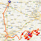
In this article you'll find the time- and route schedule of the race and the Google Maps/Google Earth version of the Tour of Flanders 2013 race route.
CONTINUE READING AFTER THIS ADVERTISEMENT
The Tour of Flanders 2013 race route on Google Maps
The Tour of Flanders celebrates its 100th anniversary with the 97th edition of the race tomorrow.This 97th edition will not bring back the famous Muur van Geraardsbergen which was removed from the race route in 2012 but will keep the principles of last year's race route with start on the Market of Bruges, a first part which follows an almost straight line on a flat course towards the border with France. Going towards the finish city Oudenaarde (finish city of the Tour of Flanders since 2012), the riders will get to the 17 climbs which make the final without any rest points for this race.
The 17 climbs on the programme in 2013 are almost the same as in 2012. The Nokereberg has however been replaced by the Tiegemberg:
1/ Tiegemberg - 750m - 5.6% (max 9%)
2/ Taaienberg - 530m - 6.6% (max 10%)
3/ Eikenberg - 1300m - 6.2% (max 10%)
4/ Molenberg - 463m - 7% (max 14.2%)
5/ Rekelberg - 800m - 4% (max 9%)
6/ Berendries - 940m - 7% (max 12.3%)
7/ Valkenberg - 540m - 8.1% (max 12.8%)
8/ Oude Kwaremont - 2200m - 4% (max 11.6%)
9/ Paterberg - 360m - 12.9% (max 20.3%)**
10/ Koppenberg - 600m - 11.6% (max 22%)
(feeding zone)
11/ Steenbeekdries - 700m - 5.3% (max 6.7%)
12/ Kruisberg/Hotond - 2500m - 5% (max 9%)
13/ Oude Kwaremont - 2200m - 4% (max 11.6%)
14/ Paterberg - 360m - 12.9% (max 20.3%)
15/ Hoogberg/Hotond - 3000m - 3.5% (max 8%)
16/ Oude Kwaremont - 2200m - 4% (max 11.6%)
17/ Paterberg - 360m - 12.9% (max 20.3%)
** the nice anecdote about the Paterberg is that it has been part of the Tour of Flanders only since 1986. Indeed, that year a farmer who was passionated by the race invited the organiser of the race to show them a paved zone he created in the middle of one of his fields and following this visit, this new climb was integrated in the race route of the Belgian classic.
Hereunder you'll find the time- and route schedule and the Tour of Flanders 2013 race route on Google Maps. Click on the images to open them.


>> Click here to see how the different loops at the end of the race follow up on each other and to see the race profile of the Tour of Flanders 2013
The Tour of Flanders 2013 race route in Google Earth
Would you like to see the race route of this Belgian classic in Google Earth instead so you could for example do a virtual fly-over of the race? That's possible by downloading the following KML file:>> Download the Tour of Flanders 2013 race route in Google Earth

Vond u dit artikel interessant? Laat het uw vrienden op Facebook weten door op de buttons hieronder te klikken!
1 comment | 12068 views
this publication is published in: Classics | OpenStreetMap/Google Maps/Google Earth


 by marco1988 over
On nous annonce que, normalement, les routes resteront sèches. Par ce froid HIVERNAL, il vaudrait mieux !!!
"P 22"