In a few days, the 2014 Tour Down Under will start in South-Australia, in Nuriootpa to be more precise. 815.5 kilometers further, in Adelaide, we'll know who will be the winner of the first race of the UCI WorldTour 2014.
This will all, as usual, be preceded by the People's Choice Classic, which is not officially part of the Tour Down Under but which is part of the official UCI criterium calendar which thus allows the riders of the UCI ProTeams to participate.
In this article you'll find all information about the race route of the Tour Down Under 2014 including most importantly Google Maps/Google Earth maps of the stages and the profiles of each of the stages.
The Tour Down Under 2014 will take place from Tuesday 21 till Sunday 26 January 2014 and is since several years now the first race of the UCI WorldTour, thus preceding Paris-Nice which will as usual take place in March.
The Tour Down Under 2014 race route on Google Maps
Let's check out the different stages one by one ...CONTINUE READING AFTER THIS ADVERTISEMENT
Sunday 19 January 2014 - People's Choice Classic - 51 km
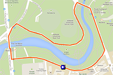
It'll all start with the People's Choice Classic which is thus not officially part of the Tour Down Under as a UCI WorldTourevent but which is a UCI sanctioned criterium.The closed circuit is no longer the 1.7 kilometers long circuit around Rymill Park but a completely new 2 km circuit close to the Adelaide Zoo will form the completely flat race route for this People's Choice Classic. The riders will do 25 laps on this new circuit which means they'll get to a total distance of 50 kilometers. The start of the race will be at 7.15PM for an expected finish around 8.15PM.
At the 5th, 10th, 15th and 20th crossing of the finish line on Victoria Drive, the riders can take additional primes in a sprint.
Hereunder you'll find the race route of the People's Choice Classic on Google Maps and its profile. Click on the images to open them.


Tuesday 21 January 2014 - 1/ Nuriootpa > Angaston - 135 km
The first stage of the Tour Down Under 2014 will start in Nuriootpa, just north of Adelaide, and will run to Angaston over 135 kilometers.Once the riders quit the neutralised zone, they will turn right towards Greenock on the first of the two circuits which make up this stage. The first two laps are on a circuit which brings them via Greenock, Seppeltsfield and Tanunda towards the sprint in Bethany (sprint on both laps) and then via Vine Vale and the finish in Angaston back to Nuriootpa. After these two laps they'll get on the third lap which is identical to the two previous ones except for the part after Bethany (where they won't sprint this time). Indeed, from there, they go on east to go find Menglers Hill. After the descent of this climb they'll follow a slightly different road towards the finish which will be slightly uphill.


Wednesday 22 January 2014 - 2/ Prospect > Stirling - 150 km
After the start of the second stage from Prospect, the peloton will first go north, up to Elizabeth. From there, they will briefly go east to the sprint on One Tree Hill, from where they'll go back down south, climbing the Golden Grove. The stage will then continue east via the Checker Hill climb and then further south. After an intermediate sprint in Woodside, the riders will go towards the finish in Stirling but they'll still have to do a local loop around this finish city before we'll know the winner of this stage!

Thursday 23 January 2014 - 3/ Norwood > Campbelltown - 145 km
After the start from Norwood, this 3rd stage will pass close to the finish while still in the neutralised zone which ends only at Paradise. Quickly after this real start, the riders will do a local loop in the stage via Paracombe, Inglewood and Houghton and then back to Paracombe from where they'll continue their route towards Kersbrook where they'll find the first intermediate sprint.From there, they'll continue up north to Williamstown where they'll battle for the second sprint. Going east they arrive in Easton where they'll turn right back south via the feeding zone in Mount Pleasant. Via Mount Torrens and Birdwood they'll then turn south-west towards the finish in Campbelltown, which will be preceded by the climb of Corkscrew Road in Montacute.


CONTINUE READING AFTER THIS ADVERTISEMENT
Friday 24 January 2014 - 4/ Unley > Victor Harbor - 148.5 km
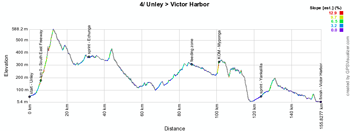
The fourth stage between Unley and Victor Harbor is different from the one that took place between these two locations in 2012.Starting from Unley, the riders will go south-east via the sprint in Echunga and down to the Cox Scrub Conservation Reserve. From there they'll go more west and south-west, via the feeding zone, a climb in Myponga and an intermediate sprint in Yankalilla.
When they'll battle for this sprint they'll have already started the last part of the stage, going east towards Victor Harbor.


Saturday 26 January 2014 - 5/ McLaren Vale > Willunga Hill - 151.5 km
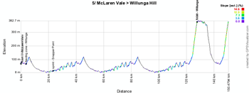
The 5th stage has now really become a classic for the Tour Down Under since it uses the now famous race route between McLaren Vale and Willunga. In order to allow this stage to finish on top of Old Willunga Hill and to give a climber a chance to win it, the stage has been made a bit longer since 2012 (from 131 to 151.5 kilometers) by doing 3 times the longest loop between McLaren Vale, Willunga and Snapper Point (where they'll battle for a sprint twice) instead of 2 times and only one time (instead of 2 times as well) the shorter loop, with this time the finish on top of Old Willunga Hill. Due to the localisation of this climb, the riders will climb it twice anyway in this stage. This change has been kept for 2014 with the same stage route as in the last two years.Hereunder you'll find the race route of the fifth stage of the Tour Down Under 2014 on Google Maps and its profile. Click on the images to open them.


Sunday 27 January 2014 - 6/ Adelaide > Adelaide - 85.5 km
The sixth stage was quite a classic as well in the Tour Down Under, since it took place every year on a 4.5 km long circuit in the city center of Adelaide. This year, there's a new circuit which is 4.75 km long and instead of doing 20 laps, the riders will now do 18 laps to get to a total distance of 85.5 kilometers (versus 90 before).Hereunder you'll find the race route of the sixth stage of the Tour Down Under 2014 on Google Maps and its profile. Click on the images to open them.


The Tour Down Under 2014 race route in Google Earth
If you prefer to see the race route of all the Tour Down Under 2014 stages in Google Earth, you can (if necessary after having installed Google Earth) click on the following link:> Download the Tour Down Under 2014 race route in Google Earth

Vond u dit artikel interessant? Laat het uw vrienden op Facebook weten door op de buttons hieronder te klikken!
no comments yet | 4816 views
this publication is published in: Tour Down Under | Tour Down Under 2014 | OpenStreetMap/Google Maps/Google Earth


 by marco1988 over