Monday 10 February 2014 at 18h45
The second French stage race usually is the Tour Med and the 41st edition of this race, which official name is the Tour Méditerranéen Cycliste Professionnel, is not an exception on this rule. The 2nd edition organised by its new organisors, André Martres and Claude primard, will take place from 13 till 16 February, between Argelès-sur-Mer and the famous Mont Faron above Toulon.
In this article you'll discover the race route of the Tour Med 2014 in Google Maps/Google Earth.
The Tour Med 2014 race route
This edition shows a small change in the programme compared to last year when the Tour Med got back its 5th stage, with 5 race days. This year, from Thursday till Sunday (that is, in 4 days), we'll still see 5 stages for the Tour Med, for a total distance of 668 kilometers, thanks to the division of the Saturday in two stages: one short stage in line in the morning and an individual time trial of 18.2 kilometers around Saint-Rémy-de-Provence in the afternoon.CONTINUE READING AFTER THIS ADVERTISEMENT
1/ Thursday 13 February 2014 - Argelès-sur-Mer > Montagnac - 223.5 km
The first stage of the Tour Med 2014 will start in the south of France, in Argelès-sur-Mer.Rapidly after the start, the riders will go land-inwards, on their way to the climbs of the Col de Tautavel (3rd category) and the Col d'Extrême (3rd category). They'll continue their route towards Narbonne, but will turn around this city after having taken in some addition energy in the feeding zone in St Julien de Septime. They'll also turn around Béziers to go towards the finish line in Montagnac. Before they get there however, they'll turn left to do a short loop via Saint-Pons-de-Mauchiens before they get back to Montagnac where they'll do an intermediate sprint at the first crossing of the finish line. They'll then again do this loop before we get to know the winner of this first stage.
Hereunder you'll find the itinerary tables, the stage profile and the race route on Google Maps for this stage. Click on the images to open them.


2/ Friday 14 February 2014 - Cadolive > Rousset - 170.6 km
On Valentine's day, the second stage of the Tour Med 2014 will await the riders, starting in Cadolive, not far from Aix-en-Provence.The finish city, Rousset, is not far from there and the riders already get there after only 13.8 kilomèeters in the race. The stage is far from done there however since they'll still have to do 156.8 kilometers before they finally cross the finish line.
From Rousset they'll go towards Pourrières where they'll start the climb of the Col de Pourrières (3rd category) and continue their route to Rians. They'll then turn east towards Tavernes where they'll go back down south via Barjols and the feeding zone at the exit of Brue-Auriac. They'll then continue their descent down to Mazaugues before they'll climb another 3rd category climb and pass via Nans-les-Pins towards the sprint at the Golf de la Sainte-Baume.
They'll get on a part of the race route of the Grand Prix Cycliste La Marseillaise where they'll climb the Col du Petit Galibier (outside category, officially called Pas de la Couelle). Via Trets and Peynier they'll turn back to Fuveau where they'll get back on the race route which brought them to the finish city right from the start. After 170.6 kilometers, they'll cross the finish line for the second time, this time for victory!
Hereunder you'll find the itinerary tables, the stage profile and the race route on Google Maps for this stage. Click on the images to open them.


3/ Saturday 15 February 2014 - morning - Lambesc > Saint-Rémy-de-Provence - 63 km
The 3rd stage is relatively short, 63 kilometers from the start in Lambesc, since this is the stage for Saturday morning, which will be followed in the afternoon by the individual time trial of the race.Right from the start, the riders will climb the Côte de Lambesc-Charleval of the 2nd category and then turn west via Eyguières and up to the sprint in Maussane-les-Alpilles. They'll then go on towards Les Baux de Provence where they'll climb a second 2nd category climb before they arrive at their destination for this morning, Saint-Rémy-de-Provence.
Hereunder you'll find the itinerary tables, the stage profile and the race route on Google Maps for this stage. Click on the images to open them.


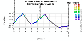
4/ Saturday 15 February 2014 - afternoon - Saint-Rémy-de-Provence > Saint-Rémy-de-Provence - 18.2 km - individual time trial
The Saturday afternoon, the riders will have to do an individual effort in the time trial around Saint-Rémy-de-Provence.The profile of this individual time trial shows two climbs: one right from the start, towards the south and the second when they turn towards Les Baux-de-Provence where they'll find an intermediate timing point and where they'll climb the same climb which was a 2nd category climb in the morning stage.
Hereunder you'll find the itinerary tables, the stage profile and the race route on Google Maps for this stage. Click on the images to open them.


CONTINUE READING AFTER THIS ADVERTISEMENT
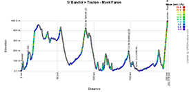
5/ Sunday 16 February 2014 - Bandol > Toulon / Mont Faron - 192.7 km
The 5nd and last stage of this 41st Tour Med will start in Bandol and will be quite hilly towards the finish on top of the Mont Faron above Toulon for an interesting final.After the start the riders will go through Le Beausset towards the north before they turn right towards Signes, Rocbaron and Puget-Ville, where they'll go down south again. In Pierrefeu-du-Var they'll continue their trip towards the east via the climb of the Col de Taillude of the 2nd category and the Col du Périer.
In Grimaud they'll again go south for a short loop starting in Cogolin via Gassin and La Croix-Valmer before they get back to Cogolin from where they'll turn left towards the Col de Grateloup (3rd category) and the sprint in La Londe les Maures.
After having turned around Hyères and La Garde the riders will go on towards Toulon where they'll finish the stage with the climb of the Mont Faron which has often played an important role in the general classification of the Tour Med and which thus gets back at its ideal place at the end of the race to keep the suspense until the end!
Hereunder you'll find the itinerary tables, the stage profile and the race route on Google Maps for this stage. Click on the images to open them.


The Tour Med 2014 race route in Google Earth
You have just discovered all the details about the different stages of this 41st Tour Med including the itinerary tables and the stage profiles and for each of them the Google Maps version of the race route.If you would like to see the full Tour Med 2014 race route at a glance, you can download the following KML file and open it in Google Earth.
>> Download the Tour Med 2014 race route in Google Earth

Due to the relatively few details provided by the organisor of the race, I can not guarantee the exact locations of stage starts and km 0 locations neither of the roads which connect these two points. The other elements should be rather correct even though the streets the race uses to cross the different cities and towns might differ a bit. If you use these informations to go see the race, please make sure you ask locally to make sure you won't miss it! :-) door Thomas Vergouwen
Vond u dit artikel interessant? Laat het uw vrienden op Facebook weten door op de buttons hieronder te klikken!
no comments yet | 11549 views
this publication is published in: Tour Med | OpenStreetMap/Google Maps/Google Earth


 by marco1988 over