Thursday 06 March 2014 at 22h28
This weekend, on Sunday to be precise, the Race to the sun - which is the nickname for Paris-Nice - will start in Mantes-la-Jolie for 8 stages in line, towards Nice and its famous Promenade des Anglais, in a total distance of 1,446.5 kilometers (almost 275 more than last year for example).
In this article you'll find, as usual, the detailed race route of Paris-Nice 2014 on Google Maps/Google Earth, as well as the itineraries and the profiles of the different stages of this race.
The Paris-Nice 2014 race route on Google Maps
Hereunder you'll discover all details of the Paris-Nice 2014 race route with all the important points of each of the stages, the exact locations of starts, finishes, sprints and climbs but also the route the riders will follow between the fictive start and km 0 of the stages.The race route of this Paris-Nice is quite original, of course because there's no single time trial, neither at the start nor at the end like the previous years and not even in-between. This is one of the reasons that the total distance of this edition of the race to the sun is very high. Furthermore, there's no real mountain stage with a mountain top finish. Some people criticised this race route as being boring, others see the opportunity to have a very open race where many riders have a chance to show off, depending on how the race unfolds, the influence of the weather (which is expected to be quite good!) and any potential mechanical problems the leaders of the different teams might run into.
CONTINUE READING AFTER THIS ADVERTISEMENT
1/ Sunday 9 March 2014 - Mantes-la-Jolie > Mantes-la-Jolie - 162.5 km
It all starts with a 162.5 kilometer long race starting and finishing in Mantes-la-Jolie, close to Paris in the Yvelines department.With the start and finish being in the same city, one could think this to be a prologue or a first stage as a time trial. This is however not the case, since this is a stage in line with two circuits: one north of the city and one at the south side with the latter one being done 4 times.
In the northern circuit there's an additional short circuit: starting in Mantes-la-Jolie the riders go north but they rapidly turn right in Fontenay-Saint-Père to go find Sailly and then come back to Fontenay-Saint-Père via Drocourt, this time to turn right to go find the most northern point of this stage, close to Vétheuil.
From there they descend to Mantes-la-Jolie again, where they'll turn left to get on the second circuit of this first stage. They continue south towards Vert and its Côte de Vert (3rd category) which will thus be climbed 4 times but which counts for the King of the Mountains classification only at the first and the third crossing. When they get in Boinvillers they reached the most southern point of this stage and they go back north to Mantes-la-Jolie.
At the first and the third crossing of the finish line, they'll battle for the intermediate sprint while the finish line transforms into the feeding zone at the second crossing.
At the 4th crossing of the finish line (on the Voie de Berge) we'll thus know who will be the first rider of this 72th edition of Paris-Nice to wear the yellow jersey.
Hereunder you'll find the itineray, the profile and the map with the race route of this stage. Click on the images to open them.


2/ Monday 10 March 2014 - Rambouillet > Saint-Georges-sur-Baulche - 205 km
The second stage will also start in the Yvelines department, a bit further south, in Rambouillet just south of the Vallée de Chevreuse.This stage's race route is almost straight-lined and goes south-east via Dourdan, Etampes, the sprint in Malesherbes, the feeding zone at the exit of Préfontaines, and will then continue via Château-Renard and the Côte de La Ferté-Loupière of the 3rd category towards the finish in Saint-Georges-sur-Baulche.
The riders will only have ridden 186,5 kilometers out of 205 at that time since a local circuit via Perrigny, Les Courlis and Charbuy awaits them before they can cross the finish line for victory.
( As a useful tip for those among you who also check the information provided by the organisor of the race: the map of this stage is incorrect on the official website and in the official race roadbook. Indeed, the track is correct but the background with the map (including all routes which are on it) has been moved up. I informed ASO of this problem but apparently, at the time of writing of this article, they haven't been able to correct it yet. )


3/ Tuesday 11 March 2014 - Toucy > Circuit de Nevers Magny-Cours - 180 km
Another quite flat stage is on the programme this Tuesday 11 March, between Toucy and the famous Circuit de Nevers Magny-Cours, usually the place-to-be for car races.After the start from the Place André et Robert Genet in Toucy, the riders go off to Saint-Fargeau where one of the stages of Tour de France 2009 finished. From there, they'll briefly go east-west via Saint-Sauveur-en-Puisaye and Saint-Amand-en-Puisaye and continue south-east via the Côte de la Chapelle-Saint-André of the 3rd category, via the sprint in Varzy and the feeding zone de ravitaillement in Brinon-sur-Beuvron. From there they'll go straight south down to the sprint in La Machine before they start the final part of the stage which goes west towards the car race circuit south of Nevers.
They'll get on the circuit on the north-west side and will do an almost complete lap before they battle for stage victory in front of the stands.


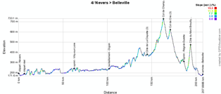
4/ Wednesday 12 March 2014 - Nevers > Belleville - 201.5 km
The 4th stage of Paris-Nice 2014 will start from the city center of Nevers, a few kilometers north of the finish the day before. The stage starts quite easily, going south-east via Decize, the intermediate sprint in Vitry-sur-Loire and Bourbon-Lancy.This stage however gets a bit more hilly after the feeding zone in Digoin, when the riders will have to climb 3 difficulties of the 3rd category: the Côte de la Clayette to start with and then the Col de Champ Juin, 7.5 kilometers further followed by the Col de Crie.
They'll battle for the second intermediate sprint of this stage in Régnié-Durette and before they get to the finish line in Belleville, they get off the main road in Cercié to climb the Côte du Mont Brouilly, the first 2nd category climb of this race to the sun.
They'll get back on the main road to continue towards Belleville and the finish will be in the Rue de la République after having turned around the city on the north.


CONTINUE READING AFTER THIS ADVERTISEMENT
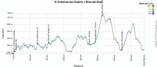
5/ Thursday 13 March 2014 - Crêches-sur-Saône > Rive-de-Gier - 153 km
This 5th stage is rather short, with its 153 kilometers and the race routes only offers 3 short 3rd category climbs and one 2nd category climb.The start of this stage will be close to Crêches-sur-Saône's train station, a few kilometers north of the finish the day beore. From there, the riders will go towards Régnié-Durette where they'll cross the race route of the previous stage. They'll however not climb the same 2nd category difficulty as the day before this time but the riders will climb its little sister, the Col de Brouilly, of the 3rd category.
They'll continue their trip southwards to go climb the Côte de Plantigny, also of the 3rd category, and will then go via Chessy and Lozanne to a new part of the race route which goes plain south, outside of Lyon via Lentilly and Vaugneray.
They'll battle for the intermediate sprint in Brindas before they continue south-west via the feeding zone just after Thurins and via the Côte de Saint-Martin-en-Haut, the last difficulty of the 3rd category in this stage.
11 kilometers further south they'll get on a final circuit around Rive-de-Gier where the finish will be on the Quai Fleurdelix. After the first crossing of the finish line, they'll battle for the second intermediate sprint of this stage and will then go on to Sainte-Catherine where they'll climb the last difficulty of the day, the Côte de Sainte-Catherine, a 12.5 kilometer long climb at 2.8%, registered as a 2nd category climb which has its summit at 12.5 kilometers from the finish.


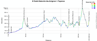
6/ Friday 14 March 2014 - Saint-Saturnin-lès-Avignon > Fayence - 221.5 km
After a big transfer south (of over 200 kilometers) towards Avignon, the 6th stage will be the first stage which goes from west to east from the start in Saint-Saturnin-lès-Avignon.After having visited L'Isle-sur-la-Sorgue, the riders will go on to Bonnieux and the climb of its Côte de Bonnieux of the 3rd category, rapidly followed by the intermediate sprint in Lourmarin. They'll then pass north of Aix-en-Provence and continue to the feeding zone in Rians and then to Draguignan where they'll get on the climb of the Côte des Tuilières, a 2nd category climb which was most recently on the programme of the Tour du Haut Var 2014.
A bit over 15 kilometers further they'll get on the summit of the next difficulty, the Côte du Mont Méaulx, of the 3rd category. They'll then continue to Fayence, the finish city of this stage, but the intermediate sprint they'll find here will not be on the finish line but at about 3 kilometers from there.
They'll turn left to get to the finish lien and will then continue on a local circuit north of the city Fayence in which they rapidly get on the climb of the Col de Bourigaille, the first 1st category climb of this race which will have its summit at 19 kilometers from the finish.
Once they get on the top of this climb, they'll get back down and end this stage with a last small climb towards the finish in Fayence, which is referenced as a 2nd category climb.


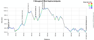
7/ Saturday 15 March 2014 - Mougins > Biot Sophia Antipolis - 195.5 km
The forelast day of Paris-Nice 2014 will offer the riders a stage with a quite complicated race route if we judge it only by seeing it on a map. After the start just outside the circular city center of Mougins, they'll do several loops in the backland of Nice.They'll first go to Valbonne where they turn north-east via Roquefort-les-Pins and Bar-sur-Loup and the switchback to the intermediate sprint in Tourrettes-sur-Loup. Via Vence they then go north to start the climb of the Col de Vence of the 1st category, which is 9.7 kilometers long.
They'll continue up to Coursegoules where they turn left and just before Gréolières they'll again turn left to start the climb of the Côte de Cipières of the 3rd category. They'll then continue south down to Gourdon where they'll climb the Côte de Gourdon, which will not be part of the King of the Mountains classification at that time since they turn right and continue the climb towards the top of the Col de l'Ecre (1st category).
After a short trip west they'll turn back to Gréolières where they turn right to climb the Côte de Cipières again. Descending south they'll again climb the Côte de Gourdon, this time a 2nd category climb. Via Châteauneuf-Grasse they'll turn back to Valbonne where they turn left this time to go on to Biot and the finish line on the Route des Colles in Biot Sophia Antipolis. At the first crossing of the finish line they'll find the second intermediate sprint. The stage will not end there however since 2 other laps on a circuit around Sophia Antipolis will end of this stage. This last part of the race route doesn't contain any difficulties.


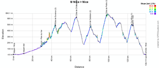
8/ Sunday 16 March 2014 - Nice > Nice - 128 km
The last stage of this Paris-Nice will take place on the roads behind Nice, with a start and finish on the Promenade des Anglais, after a short stage, of only 128 kilometers. Exit the time trial on the Col d'Eze, which will however be part of this stage.After the start in Nice, the riders will continue north towards the sprint in Plan du Var. They'll turn right up to Saint-Jean-la-Rivière where they'll again turn right to climb the Côte de Duranus of the 2nd category.
They'll then descend towards Tourrette-Levens but before they get there they turn east to get to the climb of the Côte de Châteauneuf just before Châteauneuf-Villevieille.
The riders will then continue their trip east until the climb of the Col de Calaïson, also a 2nd category climb. From there they'll start the descent back to Nice via the climb of the Côte de Peille, a 1st category climb. The descent back south will continue until La Turbie, where the riders will turn south-west, towards Eze. They'll turn left to descend towards Villefranche-sur-Mer, but before they get there they'll turn right to climb the Col d'Eze, rapidly followed by the intermediate sprint in Eze. They'll turn right for the last time to descend the same road down to Villefranche-sur-Mer and then towards the finish in Nice, on the Promenade des Anglais.


The Paris-Nice 2014 race route in Google Earth
You have just discovered all details of the race route of the 72nd edition of Paris-Nice, with its itineraries (time- and route schedules), its profiles and the maps with the race routes on Google Maps for each of the stages. If you'd like to see the full race route of Paris-Nice 2014 in one view, you can download the following KML file and open it in Google Earth:>> Download the Paris-Nice 2014 race route in Google Earth (KML file)
This file also allows you to do a virtual fly-over of one or more of the stages of Paris-Nice 2014.

If you click on the icons shown on the different maps in this article or in Google Earth, you'll find more details related to the start and finish locations, sprints, feeding zones and the different climbs. door Thomas Vergouwen
Vond u dit artikel interessant? Laat het uw vrienden op Facebook weten door op de buttons hieronder te klikken!
6 comments | 22381 views
this publication is published in: Paris-Nice | Paris-Nice 2014 | OpenStreetMap/Google Maps/Google Earth


 by marco1988 over
Comme d'habitude, très bon boulot Thomas. :) Un tracé du Paris-Nice pas si mauvais que ça, on sent qu'ASO a envie d'explorer et de proposer du nouveau. Le parcours souffrait un peu de la comparaison avec Tirreno-Adriatico, mais Paris-Nice semble au-dessus cette année.
(Petit message personnel à Thomas : j'ai un Tour fictif en attente dans la rubrique A Votre Tour ! Et ce n'est ni un Tour de France, ni un Giro, ni une Vuelta ! Ce serait sympa de pouvoir le valider ^^)
En effet, les parcours d'ASO sont souvent très critiqués. Pour ce Paris-Nice, le parcours devrait permettre aux puncheurs et attaquants de s'exprimer. De plus, sans contre-la-montre, les favoris seront obliger d'attaquer sous peine de laisser un baroudeur l'emporter...
Merci Thomas, en fait j'attendais sur l'autre article lol
J'ai cru voit une petite faute : il ne manque pas une Cote de Vert sur le 3ème tour de circuit sur la premiere étape ?
zut j'espère que je ne vais pas me taper les routes barrées !!! verdict demain 9h20 !!! c mon heure de circulation !!!! bzzzzzzzzzz...
@Loulou #3 : ce n'est pas une faute, c'est dû au fait que les profils sont générés automatiquement et dès qu'un POI a été affiché une fois, toujours au premier passage, il ne s'affichera pas une deuxième fois. De la même façon il y a certaines arrivées (avec un circuit local en fin d'étape) qui sont affichées avant la fin de l'étape (au premier passage de la ligne). Dans tous les cas, les descriptions des étapes sont correctes.
@Linkinito #1 : désolé, pas le temps en ce moment de valider des "A votre Tour". Je vais voir si je peux le faire rapidement. Dans tous les cas, je ferai remonter les messages sur lesquels j'ai du retard soit en modifiant la date soit en laissant un petit commentaire dessus.
bravo pour ton travail.Seul petits soucis les erreur de parcours.
En effet j'habite sur le parcours de l'etape de Belleville,il ne passait pas par le centre de Beaujeu comme indiqué,la route de la montée de brouilly n'est pas la bonne et celle de la descente non plus.
mais il est vrai que pour avoir les indications exacts il fallait etre fort.