This Sunday one of the races known as a preparation race for the Tour de France, the Critérium du Dauphiné 2014 will start in Lyon with an individual time trial which will be followed by 7 stages in line.
1187.4 kilometers and a short visit of Switzerland further, we'll know who will go home with the yellow-blue leader's jersey of the general classification and who will thus be a good candidate for the general classification of the Tour de France 2014.
After having recognised the first stages of the 101st edition of the Grande Boucle in the past few days, Chris Froome (Team Sky) will come to the start in Lyon, together with Alberto Contador (Tinkoff-Saxo) and Vincenzo Nibali (Astana Pro Team) and we can thus judge their shape at less than one month from the start of the Tour ...
The Critérium du Dauphiné 2014 race route on Google Maps, the time- and route schedules and the stage profiles
Let's now have a look at the precise informations about the race routes of the different stages, with the exact race route, as usual shown on Google Maps.CONTINUE READING AFTER THIS ADVERTISEMENT
1/ Sunday 08 June 2014 - Lyon > Lyon - individual time trial - 10.4 km
This year, Critérium du Dauphiné will start with an individual time trial, in the streets of Lyon.This time trial follows quite an original track because just after the start on the Avenue du Maréchal Foch, the riders will go into the soft transport modes pipe of the tunnel of la Croix Rousse. This tunnel was completely renovated in 2013 and this additional pipe, which contains a bus lane, a bike lane and a footpath, was created at this occasion and opened to the public on 5 December.
This pipe, 1,763 meters long, takes a cyclist from Lyon 8 minutes to get from one side to another according to the presentation by Grand Lyon while the time- and route schedule of this stage in the Dauphiné shows it should take only 2 minutes for the professional cyclists! It doesn't say whether the animated images which are usually shown on the walls of this pipe will also accompany the progression of the cyclists or not.
Once they get out of the tunnel, which brings the riders from the Rhône to the Saône, they turn right on the quay up to the round about where they will turn around to go towards the Montée de l'Observance (4th categorie) and on the top of this climb the intermediate time will be observed.
After the descent they'll follow the Saône quay and they'll cross the river at the Vieux Lyon city center on the Pont Bonaparte and then follow the quay on the other side down to juster after the Lyon-Perrache train station where they go further on the peninsula and end off the stage close to the Hôtel de région of the Rhône-Alpes region.
Hereunder you'll find the time- and route schedule, the stage profile and the race route on Google Maps for this stage. Click on the images to open them.


2/ Monday 9 June 2014 - Tarare > Pays d'Olliergues-Col du Béal - 156 km
At the north-west of Lyon, the riders will start the 2nd stage in Tarare and right after kilometer 0 they'll start the climb of the Côte de Saint-Marcel-l'Éclairé (4th category, 5 km long @ 6.1%). Its descent will immediately go on in the climb of another 4th category hill, the Côte d'Albigny (2.3 km @ 5.5%).After a north-west loop around Feurs, the peloton goes on to the feeding zone in Les Comolons (Mornand-en-Forez) and towards the climbs of the Côte de Bard (2nd category, 6.3 km @ 5.3%), Col de la Croix de l'Homme Mort (2nd category, 5.6 km @ 5.6%) and the Col des Pradeaux (3rd category, 7.3 km @ 3.6%).
Via the sprint in Ambert, the start place of the next day's stage, the riders go back up north towards the border between the Puy-de-Dôme and Loire department which is formed by the Col de Béal (hors category, 13.6 km @ 6.6%).
Hereunder you'll find the time- and route schedule, the stage profile and the race route on Google Maps for this stage. Click on the images to open them.


3/ Tuesday 10 June 2014 - Ambert > Le Teil - 194 km
After the start in Ambert this Tuesday, the first 20 kilometers of the stage are pretty flat, before the riders start the climb of the Côte de Lavet (2nd category, 8.7 km @ 4.4%). They'll continue their trip south-east, towards the feeding zone in Saint-Agrève and to the climb of the Col de la Mûre (2nd category) which is only 3.8 km long but with an average steepness of 6.3%.At the bottom of this climb, the riders will battle for the intermediate sprint of Saint-Laurent-du-Pape and then go straight south towards Le Teil where the finish line will be drawn in the Allée Paul Avon.
Hereunder you'll find the time- and route schedule, the stage profile and the race route on Google Maps for this stage. Click on the images to open them.


4/ Wednesday 11 June 2014 - Montélimar > Gap - 167,5 km
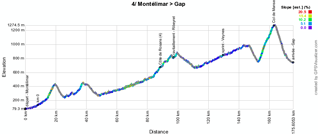
The start in Montélimar is not far from yesterday's finish and this time a west-east stage will be awaiting the riders of the Critérium du Dauphiné 2014.The profile of this stage shows a progressive climb via the top of the Côte de Rosans (4th category, 1.5 km @ 3.6%) which will be located halfway the stage, via the feeding zone in Ribeyret and via the intermediate sprint in Veynes. Close to the finish in Gap things will get a bit more complicated because the riders won't go directly off to the finish but turn left onto the Route de Napoléon where they already start the climb, which will continue when they turn right towards the Col de Manse (2nd category, 9.6 km @ 5.2%).
If you'd like to discover this climb (or watch it again) in the video I produced last year during the Critérium du Dauphiné because the Tour de France was taking this climb, you can check out the video below (you can skip to a specific location in the video by moving the bike on the map to that location):
After this last climb, the descent will bring the riders to the finish line in the Avenue Maréchal Foch.
Hereunder you'll find the time- and route schedule, the stage profile and the race route on Google Maps for this stage. Click on the images to open them.


CONTINUE READING AFTER THIS ADVERTISEMENT
5/ Thursday 12 June 2014 - Sisteron > La Mure - 189.5 km
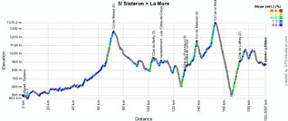
Just like in the Tour de France 2013, after the start from Sisteron the riders will climb the Col de Manse (2nd category, 6.6 km @ 6.2%) in the opposite direction and they'll already have done 68.5 kilometers when they arrive on top of this climb.If you'd like to discover this climb of the Col de Manse from La Bâtie Neuve (or watch it again) with the video I produced last year during the Critérium du Dauphiné because the Tour de France was taking this climb, you can watch the videos below. Indeed, this video is cut into two parts because I had to stop to help a friend who had a flat tire in the descent following our climb in the other direction (of course you can move the video to a specific location by moving the bike on the map again):
After the climb of the Col de Manse, the riders will do about sixty kilometers, via the Côte du Motty (3rd category, 2.3 km @ 8.1%), the feeding zone in Les Côtes-de-Corps and the climb of the Côte du Pont-Haut (3rd category, 2.7 km @ 7.4%), to get to the finish in La Mure. However, when they cross the finish line for the first time and battle for the intermediate sprint, they'll still have 61.5 kilometers to do on a circuit around the finish city.
This circuit brings them to the climbs of the Col de Malissol (3rd category, 2 km @ 8.8%), the Col de la Morte (2nd category, 3.1 km @ 8.4%) and finally the Côte de Laffrey (2nd category, 6.3 km @ 6.2%) before they cross the finish line for the second time, this time for the stage win!
Hereunder you'll find the time- and route schedule, the stage profile and the race route on Google Maps for this stage. Click on the images to open them.


6/ Friday 13 June 2014 - Grenoble > Poisy - 178.5 km
The 6th stage will start a little bit further north, in Grenoble, and will turn around Voiron and continue towards the feeding zone in Nances. Once they've taken some extra energy there, the riders will climb the Côte de la Bétaz (4th category, 1.5 km @ 4.4%) and continue their trip further north.Just before they get to Seyssel, they turn right towards Rumilly via the intermediate sprint in Vallières. Going on towards the finish line, they still have two hills to climb: the Côte de Marcellaz-Albanais (4th category, 4.6 km @ 4.1%) and the Côte de Ronzy (4th category, 1.7 km @ 6.3%) and the top of the last mentioned hill will be at only 7.5 kilometers from the finish in Poisy, close to Annecy.
Hereunder you'll find the time- and route schedule, the stage profile and the race route on Google Maps for this stage. Click on the images to open them.


7/ Saturday 14 June 2014 - Ville-la-Grand > Finhaut-Émosson (CH) - 160 km
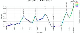
The last weekend of the Critérium du Dauphiné 2014 will contain two big mountain stages and most importantly the Saturday stage will allow to clearly fix the general classification if there hasn't been a leader of the race before that.This stage will start in Ville-la-Grand, just on the other side of the border (that is, in France) of the city of Genève. Down to Taninges this stage will start calmly but the riders will then start the climb towards Les Gets on the Côte des Gets (2nd category, 10.3 km @ 4.9%) and its descent will immediately be followed by the climb of the Col du Corbier (1st category, 7.5 km @ 7.5%).
Once they get on top of this climb, the riders go on towards the border with Switzerland which they cross on the Pas de Morgins (2nd category, 6 km @ 5.7%). They'll then descend via Monthey towards the feeding zone in Massongex and go on towards the intermediate sprint in Martigny.
Going on towards the border with France, they'll first climb the first hors category climb of this Critérium du Dauphiné, the Col de la Forclaz (12.6 km @ 8.2%), and after a few kilometers downhill they continue with the final climb, which is also a hors category, towards Finhaut-Emosson (10.2 km @ 8%).
Hereunder you'll find the time- and route schedule, the stage profile and the race route on Google Maps for this stage. Click on the images to open them.


8/ Sunday 15 June 2014 - Megève > Courchevel - 131.5 km
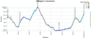
The last stage will be relatively short between Megève and Courchevel.In order to make sure it's not too short, the stage will start with a short circuit north of Megève via Saint-Gervais-les-Bains, the Côte de Domancy (2nd category, 2.5 km @ 9.6%) and Combloux, and back to Megève. From there, they go on north-west towards Flumet where they turn towards the Col des Saisies (1st category, 13.4 km @ 5.2%).
The descent will bring them to Albertville and towards the sprint in La Bâthie. From there, they'll continue north via Moûtiers and the climb of the Côte de Montagny (1st category, 8 km @ 6.5%).
They'll rapidly go on to the final climb towards Courchevel - Le Praz to be more precise (1st category, 5.9 km @ 6.2%) where we'll know the final winner of this 66th edition of the Critérium du Dauphiné.
Hereunder you'll find the time- and route schedule, the stage profile and the race route on Google Maps for this stage. Click on the images to open them.


The Critérium du Dauphiné 2014 race route in Google Earth
Do you prefer to view the complete race route of the Critérium du Dauphiné 2014 in Google Earth, whether that's to have a full view of all stages or if you want to do a virtual fly-over on one or more of the stages? That's possible, if you download the following KMZ file (a zipped KML file, due to its big size)! ATTENTION - copyright: despite the fact that this KMZ file is made available for your own use, you must note that it is strictly forbidden to reproduce the contents of this KMZ file or of any other file (including the maps, profiles, KML files and others) which make up the race route of the Critérium du Dauphiné 2014. These contents are protected by copyright and I thus ask you to respect the time I spend on the creation of those contents. This protection concerns the reproduction of the maps or other elements in any form (as a map, a video which fly over the map or any other creation based on contents as published on velowire.com).
>> Download the complete race route of the Critérium du Dauphiné 2014 in Google Earth (KMZ file, 354 kB)

Vond u dit artikel interessant? Laat het uw vrienden op Facebook weten door op de buttons hieronder te klikken!
4 comments | 36148 views
this publication is published in: Criterium du Dauphiné | Critérium du Dauphiné 2014 | OpenStreetMap/Google Maps/Google Earth


 by marco1988 over
Magnifique enchainement final le samedi.
Une étape Bourg Saint Maurice - Finhaut Emosson sur le Tour avec Petit et Grand Saint Bernard + l'ascension finale serait grandiose.
Totalement d'accord avec Dom, j'y pensais justement, c'est une idee a creuser.
Sinon j'ai peut que entre le lundi et le samedi il ne se passe pas grand chose. Position figees au general, deja des ecarts sur les baroudeurs, ca va bouger pour les victoires d'etape mais le classement evoluera peu.
La montée de Montagny dans le Tour de France, ça oui alors ça vaudrait le déplacement ! Appelez moi car je ne m'attendais pas à cela pour aujourd'hui dans le Critérium du DAUPHINÉ. ...
i really wanted to see on a map the whole route of the tour de france and i cannot pull this up like googles other maps did not likethis site