Friday 27 March 2015 at 20h36
The Belgian classics continue this Sunday with Ghent-Wevelgem, a 239 kilometer long race which visits in its second half a zone with several mounts which often have some influence on how the race develops.
In this article you'll find the race route of Ghent-Wevelgem 2015 on Google Maps/Google Earth.
CONTINUE READING AFTER THIS ADVERTISEMENT
The Ghent-Wevelgem 2015 race route on Google Maps
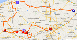
This Sunday morning, the riders and followers of the classics come back together in .. Deinze for the start of Ghent-Wevelgem. Indeed, like many races, this race still carries the name of its historical start city but since 2004 it no longer starts in Ghent.From Deinze the riders go west via Tielt, Kortemark and Diksmuide, towards the feeding zone in Veurne. They'll then continue south down to Oost-Cappel where they'll cross the border with France and go on until Wormhout. They'll then continue on their way south, down to Cassel where they climb the first mount of the day, the Mont Cassel, usually also on the programme in the 4 Days of Dunkirk. After a short loop via Oxelaëre, they'll again climb the Mont Cassel, as the secound mount of the day.
Direction south-west towards Saint-Sylvestre-Cappel from there, where they'll turn north-east towards the climb of the Mont des Cats. Back in Belgium, they briefly leave the main road to climb the Baneberg, 4th mount of the day. They'll then again have the occasion to get some new power in the feeding zone before they climb the Mont Kemmel and the Monteberg.
From Heuvelland, a loop brings them back on the road which they followed when they came back in Belgium and they'll then again climb these 3 mounts (Baneberg, Mont Kemmel, Monteberg) as the 7th, 8th and 9th mounts.
Back in Heuvelland, the riders will this time turn left towards Ypres and then right on bigger roads, towards the finish in Wevelgem.
Who will follow up on John Degenkolb who won this classic last year?
Hereunder you'll find the itinerary, the profile and the race route on Google Maps for Ghent-Wevelgem 2015. Click on each of the images to open them.


The Ghent-Wevelgem 2015 race route in Google Earth
If you prefer to open the Ghent-Wevelgem 2015 race route in Google Earth, for example to do a virtual fly-over of it, that is possible! In order to do so, simply download the KML file below and open it in Google Earth:>> Download the Gent-Wevelgem 2015 race route in Google Earth

Vond u dit artikel interessant? Laat het uw vrienden op Facebook weten door op de buttons hieronder te klikken!
no comments yet | 18854 views
this publication is published in: Classics | OpenStreetMap/Google Maps/Google Earth


 by marco1988 over