As usual, velowire.com allows you to discover in detail the race route of this 103rd edition of the Grande Boucle, with maps on Google Maps/Google Earth. The first maps were available on the French version of the website 3 weeks before the start of the Tour de France 2016 already and these have been progressively completed since. All stages are now online, with the English translation.
With the informations in this article you'll get to know all tiny details, all cities and villages which will be visited by the Tour and you'll thus be able to prepare your visit of the Tour if you plan to go there, or simply better understand the race if you're staying home!
Some preliminary information ...
Here is some preliminary information which is important to know before you get to discover the details of all the Tour de France 2016 stages:- as for any contents on velowire.com, its reproduction in any form is stricly forbidden, as explained on the copyright page. Please respect the huge amount of time it takes me to prepare contents like these!
- the profiles of the stages have been generated automatically based on the altitude informations which are available for the places where the race goes; there might thus be some places where the information is not completely correct, but the global profile still remains valid!
- at the moment these maps have been prepared, the Tour de France 2016 roadbook was not yet available for the press and the detailed informations about the stages had not yet been published on the official website of the race; the information in this article should be correct anyway however because I based it on the detailed sources of information I was able to get access to!
The programme of the Grand Départ of the Tour de France 2016
Here ar the dates to keep in mind for this Grand Départ of the Tour de France 2016:
|
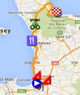
- Monday 4 July 2016 : 3rd stage - start in Granville ; the start Granville, going off to Angers, will bring up the final kilometers in the Manche department which will without any doubt have received a numerous public for the Grand Départ of this Tour de France 2016
The Tour de France 2016 race route on Google Maps
Let's now discover all the details about the Tour de France 2016 race route, stage by stage:CONTINUE READING AFTER THIS ADVERTISEMENT
1/ Saturday 2 July 2016 - Mont-Saint-Michel > Utah Beach Sainte-Marie-du-Mont - 188 km
The first stage of the Tour de France 2016 will thus be a stage in line of 188 kilometers.This first stage of the Tour de France 2016 will start at the Mont-Saint-Michel, which will be a nice backdrop for the start of this stage, after having received the Tour de France for the last time in 2013 for a time trial which finished in front of the monumental rock building.
The stage will be relatively flat over 188 kilometers, with two small climbs early in the stage, and at the finish a sprinter will thus cross the finish line first at Utah Beach, one of the landing locations on 6 June 1944 in the city of Sainte-Marie-du-Mont.
Hereunder you'll find the time- and route schedule, the profile and the race route on Google Maps for this stage. Click on the images to open them.


- start : the stage will start at the Mont-Saint-Michel, at the car park; the kilometer 0 will be on the D275, at the crossing with the chemin des Buternes on the right
- climbs : Côte d'Avranches (4th, 1.2 km at 5.7%) at km 20.5 and Côte des falaises de Champeaux (4th, 1.3 km at 4.8%) at km 39
- feeding zone : close to Gouville-sur-Mer
- intermediate sprint : Rue des Hauts Vents in La Haye at km 118.5
- finish : at Utah Beach on the D913, after a final straight line of 500 m visible (last bend at 5 km) / 6 m large
- visited departments : Manche (50) from km 0 till km 188
- main cities : Avranches, Granville, Sainte-Mère-Eglise, Sainte-Marie-du-Mont
2/ Sunday 3 July 2016 - Saint-Lô > Cherbourg-en-Cotentin - 183 km
The second stage of the Tour de France 2016 will also start in the Manche department, in Saint-Lô where the permanence of the Grand Départ will be located as well, at the Pôle Hippique-Haras national.The stage will be mainly flat following the west coast, but to get to the coast the riders will have already climbed three 4th category climbs (Côte de Torigny-les-Villes, Côte de Montabot and Côte de Montpinchon). The race route thus becomes flat after these three and gets a little bit more hilly a bit further on until Cherbourg-en-Cotentin, the finish location just after the Côte de La Glacerie. This 3 kilometers long climb going up to 14% at some place could lead to a first shift between the candidates for overall victory or at least among those who ticked this stage for a potential stage win on this second day! Chances thus are that the Maillot Jaune taken at the sprint the day before will go on the shoulders of another rider after this stage.
During the presentation of the Tour de France 2016 the finish location was presented as Cherbourg-Octeville but together with some surrounding villages it is now called Cherbourg-en-Cotentin.
Hereunder you'll find the time- and route schedule, the profile and the race route on Google Maps for this stage. Click on the images to open them.


- start : in Saint-Lô, the start will be in the Rue de Torteron ; the kilometer 0 will be on the D86 close to La Mancelière-sur-Vire
- climbs : Côte de Torigny-les-Villes (4th, 1.4 km at 5.7%) at km 10, Côte de Montabot (4th, 1.9 km at 5%) at km 23, Côte de Montpinchon (4th, 1.2 km at 5.9%) at km 52 and Côte de La Glacerie (3rd catégorie, 1.8 km at 6.7%) at km 181.5
- feeding zone : close to Bretteville-sur-Ay
- intermediate sprint : D15, rue du Père Albert, at the crossing with the rue Robert Asselin in Port-Bail at km 107.5
- finish : Les Rouges Terres (La Glacerie) in Cherbourg-en-Cotentin, after a final straight line of 350 m / 5.50 m large
- visited departments : Manche (50) from km 0 till km 183
- main cities : Saint-Lô, Coutances, Cherbourg-Octeville
3/ Monday 4 July 2016 - Granville > Angers - 223.5 km
The 3rd stage will be the last stage to start in the department of the Grand Départ, the Manche. More precisely this will be in Granville, where the first stage already came by on its way to Sainte-Marie-du-Mont.The riders will go off east first and then turn south in Villedieu-les-Poêles, via the Côte de Villedieu-les-Poêles of the 4th category. After having visited Saint-Hilaire-du-Harcouët, which has now been merged with Saint-Martin-de-Landelles where Daniel Mangeas lives, the trip south continues down to the finish in Angers.
Hereunder you'll find the time- and route schedule, the profile and the race route on Google Maps for this stage. Click on the images to open them.


- start : Boulevard des Amiraux in Granville ; the kilometer 0 on the D924
- climbs : Côte de Villedieu-les-Poêles (4th, 1.5 km at 4.4%) at km 25.5
- feeding zone : La Hargrinière / Billé
- intermediate sprint : D71 / Rue du Faubourg Saint-Mathieu, at the crossing with the D219 in Bouillé-Ménard at km 171
- finish : Boulevard de la Résistance et de la Déportation in Angers, at the end of a final straight line of 300 m visible (last bend at 330 m) / 7 m large
- visited departments : Manche (50) from km 0 till km 66.5, Ille-et-Vilaine (35) from km 72.5 till km 136.5, Mayenne (53) from km 138 till km 160.5 and Maine-et-Loire (49) from km 170 till km 223.5
- main cities : Granville, Vitré, Segré and Angers
4/ Tuesday 5 July 2016 - Saumur > Limoges - 237.5 km
The 4th stage of the Tour de France 2016 will start in Saumur and after a bit over 8 kilometers straight south until Montreuil-Bellay, the riders will turn left to go on towards Loudun and Châtellerault and continue to the feeding zone in Paizay-le-Sec. Via the sprint in Le Dorat and the only climb of the day, the Côte de la Maison Neuve of the 4th category, they'll go on until the finish in Limoges which will be slightly uphill, in front of the town hall.Hereunder you'll find the time- and route schedule, the profile and the race route on Google Maps for this stage. Click on the images to open them.


- start : Rue Beaurepaire in Saumur ; the kilometer 0 will be 10.2 kilometers further on the D347
- climbs : Côte de la Maison Neuve (4th, 1.2 km at 5.6%) at km 182
- feeding zone : Paizay-le-Sec
- intermediate sprint : Place du Champ de Foire in Le Dorat
- finish : Avenue Georges Dumas in Limoges, after a final straight line of 1.3 km / 6.50 m large, in front of the town hall
- visited departments : Maine-et-Loire (49) from km 0 till km 17, Vienne (86) from km 17.5 till km 158.5, Haute-Vienne (87) from km 169.5 till km 237.5
- main cities : Saumur, Loudun, Châtellerault, Montmorillon, Limoges
CONTINUE READING AFTER THIS ADVERTISEMENT
5/ Wednesday 6 July 2016 - Limoges > Le Lioran - 216 km
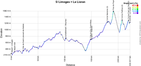
The 5th stage of the Tour de France 2016 will start in the finish city of the previous stage, Limoges, and will come through Saint-Léonard-de-Noblat where Raymond Poulidor lives, with its 4th category climb, and then goes on to Le Lioran.Before they get there, the riders will have to climb the Côte du Puy Saint-Mary (3rd category), the Col de Neronne (3rd category), the Pas de Peyrol (Puy Mary) (2nd catégorie, ^ 1,577 m / 5.4 km at 7.6%) with its last two kilometers at 12% and after its descent the riders will immediately go on with the climb of the Col de Perthus (2nd catégorie, ^ 1,309 m / 4.4 km at 7.9%) and before they get to the finish line in the Lioran ski station, they'll have to climb the Col de Font de Cère (3rd catégorie, ^ 1,301 m / 3.3 km at 5.8%).
As explained by Christian Prudhomme during the presentation of the race route, this will be an uninterrupted chain of climbs and descents in the last 50 kilometers and the favorites will thus have to stay alert right from this 5th stage!
Hereunder you'll find the time- and route schedule, the profile and the race route on Google Maps for this stage. Click on the images to open them.


- start : the start will be in the Avenue de la Libération in Limoges ; the kilometer 0 will be on the D941, at 6.2 kilometers
- climbs : Côte de Saint-Léonard-de-Noblat (4th, 1.7 km at 5.2%) at km 16.5, Côte du Puy Saint-Mary (3rd, 6.8 km at 3.9%) at km 142.5, Col de Neronne (3rd, 7.1 km at 3%) at km 173.5, Pas de Peyrol (Puy Mary) (2nd, 5.4 km at 7.6%) at km 185, Col du Perthus (2nd, 4.4 km at 7.9%) at km 201.5 and Col de Font de Cère (3rd, 3.3 km at 5.8%) at km 213.5
- feeding zone : Meymac
- intermediate sprint : Boulevard Charles de Gaulle in Mauriac
- finish : D67 at Le Lioran, after a final straight line of 170 m visible / 6 m large
- visited departments : Haute-Vienne (87) from km 0 till km 52.5, Corrèze (19) at km 53 and from km 55.5 till km 133.5, Cantal (15) from km 139 till km 216
- main cities : Limoges, Saint-Léonard-de-Noblat, Le Lioran
6/ Thursday 7 July 2016 - Arpajon-sur-Cère > Montauban - 190.5 km
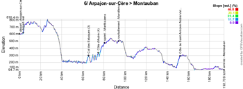
The 6th stage will start in Arpajon-sur-Cère close to Aurillac and will have Montauban as its destination following a uphill/downhill race route with a very rolling final part. This will be the last chance for the sprinters to win a stage before the race enters the Pyrenees.Hereunder you'll find the time- and route schedule, the profile and the race route on Google Maps for this stage. Click on the images to open them.


- start : Place de la République in Arpajon-sur-Cère ; the kilometer 0 will be on the D920 after 3.7 kilometers
- climbs : three difficulties will be part of this stage: the Col des Estaques (3rd, 2 km at 6%) at km 62, the Côte d'Aubin (4th, 1.3 km at 5.4%) at km 71.5 and the Côte de Saint-Antonin-Noble-Val (3rd, 3.2 km at 5.1%) at km 149
- feeding zone : Marcillenc (Maleville)
- intermediate sprint : D5/Avenue du Planhol in Montbazens at km 77.5
- finish : Avenue du 10ème Régiment de Dragons in Montauban, after a final straight line of 380 m visible / 6.50 m large
- visited departments : Cantal (15) from km 0 till km 43.5, Aveyron (12) from km 44.5 till km 118, Tarn-et-Garonne (82) from km 125 till km 154 and from km 161.5 till km 190.5, Tarn (81) at km 156.5
- main cities : Arpajon-sur-Cère, Villefranche-de-Rouergue, Montauban
7/ Friday 8 July 2016 - L'Isle-Jourdain > Lac de Payolle - 162.5 km
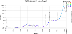
The 7th stage starting in L'Isle-Jourdain (west of Toulouse) will be the stage which will enter the Pyrenees and having as its main difficultie the Col d'Aspin (^ 1,490 m / 12 km at 6.4%). After the descent of this mountain there will still be a few hundreds of meters to climb towards the finish at the Lac de Payolle.Hereunder you'll find the time- and route schedule, the profile and the race route on Google Maps for this stage. Click on the images to open them.


- start : Rue Charles Bacqué in L'Isle-Jourdain ; the kilometer 0 will be on the D634 after 3.7 km
- climbs : Côte de Capvern (4th, 7.7 km at 3.1%) at km 117 and Col d'Aspin (1st, 12 km at 6.4%) at km 155.5
- feeding zone : on the D817 between Tournay and Ozon
- intermediate sprint : on the D929 in Sarrancolin at km 137
- finish : on the D113, pelouse Saint-Jean at the Lac de Payolle, after a final straight line of 450 m / 5 m large
- visited departments : Gers (32) from km 0 till km 27.5, Haute-Garonne (31) at km 49, Hautes-Pyrénées (65) from km 54 till km 162.5
- main cities : L'Isle-Jourdain, close to Lannemezan, Arreau, Lac de Payolle
8/ Saturday 9 July 2016 - Pau > Bagnères-de-Luchon - 184 km
The 8th stage will start in the city center of Pau, at the foot of the memorial "Le Tour des Géants" (see the official website), the collection of 104 totems which summarise the history of the Tour de France in which Pau always had quite an important presence.From Pau, the riders will go off towards Lourdes and then climb successively the Col du Tourmalet, the Hourquette d'Ancizan, the Col de Val Louron-Azet and the Col de Peyresourde. After this last climb, the riders will go downhill towards the finish in Bagnères-de-Luchon.
Hereunder you'll find the time- and route schedule, the profile and the race route on Google Maps for this stage. Click on the images to open them.

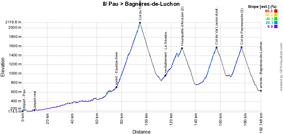

- start : Avenue Gaston Lacoste in Pau ; the kilometer 0 will be on the D938 after about 8 kilometers
- climbs : Col du Tourmalet (HC, 19 km at 7.4%) at km 86, Hourquette d'Ancizan (2nd, 8.2 km at 4.9%) at km 120, Col de Val Louron-Azet (1st, 10.7 km at 6.8%) at km 148, Col de Peyresourde (1st, 7.1 km at 7.8%) at km 168.5
- feeding zone : between La Séoube and Campan
- intermediate sprint : D918 / Avenue du Barèges in Equièze-Sère at km 67
- finish : Boulevard Edmond Rostand in Bagnères-de-Luchon, after a final straight line of 180 m / 6 m large
- visited departments : Pyrénées-Atlantiques (64) from km 0 till km 20.5, Hautes-Pyrénées (65) from km 25 till km 168.5, Haute-Garonne (31) from km 174 till km 184
- main cities : Pau, Lourdes, Bagnères-de-Luchon
CONTINUE READING AFTER THIS ADVERTISEMENT
9/ Sunday 10 July 2016 - Vielha Val d'Aran (ES) > Andorre Arcalis (AND) - 184.5 km
The 9th stage of the Tour de France 2016 will start in Spain in Vielha Val d'Aran (ES) and will stay in this country for the 125 first kilometers. The riders will find two difficulties of the first category: the Port de la Bonaigua and the Port del Cantó. After having crossed the border with Andorra, the stage will continue with two other climbs: the Côte de la Comella (2nd category) and the Col de Beixalis of the 1st catégorie. The climbing is not over after that because the stage will finish off with the long climb towards Andorra Arcalis (hors catégorie) (AND), a 10.1 kilometers long climb with an average steepness of 7.2%.Hereunder you'll find the time- and route schedule, the profile and the race route on Google Maps for this stage. Click on the images to open them.

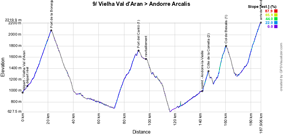
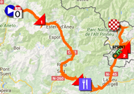
- start : on a car park close to the Carrer Dera Querimonia in Vielha (ES) ; the kilometer 0 will be 4.2 kilometers further on the C28
- climbs : Port de la Bonaigua (1st, 13.7 km at 6.1%) at km 19, Port del Cantó (1st, 19 km at 5.4%) at km 87.5, Côte de la Comella (2nd, 4.2 km at 8.2%) at km 143, Col de Beixalis (1st, 6.4 km at 8.5%) at km 157 and the final climb towards Andorre Arcalis (HC, 10.1 km at 7.2%) at km 184.5
- feeding zone : on the N260 between Guils del Cantò and Montferrer I Castellbò
- intermediate sprint : on the CG1 in Andorre-la-Vieille (AND) at km 138
- finish : Andorre Arcalis (AND) after a 10.1 km climb at 7.2%
- visited departments : Province de Lérida (ES) from km 0 till km 120.5, Principauté d'Andorre from km 132 till km 184.5
- main cities : Vielha (ES), La Seu d'Urgell (ES), Andorra la Vella (AND), Arcalis (AND)
R1/ Monday 11 July 2016 - rest day in Andorra
After the stage finish in Andorra, the riders will get some rest during the first rest day of this Tour de France 2016, still in Andorra.10/ Tuesday 12 July 2016 - Escaldes-Engordany (AND) > Revel - 197 km
The day after the first rest day the race will leave the mountains and Andorra with a stage starting in Escaldes-Engordany (AND). To leave the Principality, the riders will have to climb the Port d'Envalira (1st category), and this will be the highest climb of the Tour de France 2016, the rooftop of the Tour where the firt rider on top will receive the Souvenir Henri Desgrange, but the rest of the stage is downhill, except for the much smaller Côte de Saint-Ferréol (3rd category) which they'll go find via a short detour before the finish in Revel.Hereunder you'll find the time- and route schedule, the profile and the race route on Google Maps for this stage. Click on the images to open them.

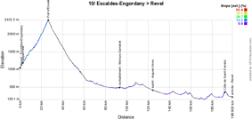

- start : Carrer de la Constitució in Escaldes-Engordany ; the kilometer 0 will be on the CG2 after 2.7 km
- climbs : Port d'Envalira (1st, 22.6 km at 5.5%) at km 24 and Côte de Saint-Ferréol (3rd, 1.8 km at 6.6%) at km 190
- feeding zone : in Mercus-Garrabet
- intermediate sprint : D625 / Avenue du 8 Mai 1945 in Aigues-Vives at km 122.5
- finish : Boulevard Jean Jaurès in Revel
- visited departments : Principality of Andorra from km 0 till km 28.5, Pyrénées-Orientales (66) from km 35 till km 141, Aude (11) from km 143 till km 172.5, Haute-Garonne (31) from km 183 till km 190 and from km 196.5 till km 197, Tarn (81) from km 190.5 till km 193.5
- main cities : Escaldes-Engordany, Ax-les-Thermes, Tarascon-sur-Ariège, Lavelanet, Mirepoix, Castelnaudary, Revel
11/ Wednesday 13 July 2016 - Carcassonne > Montpellier - 162.5 km
Between the start of this stage in Carcassonne and the finish in Montpellier, the riders will find just two difficulties of the 2nd category, in the first half of the stage, the Côte de Minerve and the Côte de Villespassans. This will certainly not prevent the sprinters who have survived the Pyrenees from doing a finish like we usually know them in Montpellier: with a bunch sprint!Hereunder you'll find the time- and route schedule, the profile and the race route on Google Maps for this stage. Click on the images to open them.


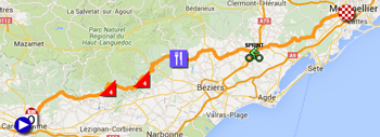
- start : Place du Général de Gaulle / Boulevard du Commandant Roumens in Carcassonne ; the kilometer 0 will be on the D620, after 6.7 km
- climbs : Côte de Minerve (4th, 2.4 km at 5.4%) at km 38 and Côte de Villespassans (4th, 2.3 km at 4.5%) at km 57
- feeding zone : Cessenon-sur-Orb
- intermediate sprint : D13E18 / Avenue Emile Combes in Pézenas at km 113.5
- finish : Avenue de Vanières à Montpellier
- visited departments : Aude (11) from km 0 till km 18.5 and at km 31 and at km 54, Hérault (34) from km 25 till km 27.5 and from km 32 till km 50 and from km 57 till km 162.5
- main cities : Carcassonne, Montpellier
CONTINUE READING AFTER THIS ADVERTISEMENT
12/ Thursday 14 July 2016 - Montpellier > Mont Ventoux - 184 km
Montpellier will also be the start city of the 12th stage and it will be 184 kilometers long towards the Mont Ventoux. Actually, the riders will be on their bike for about 200 kilometers because the kilometer 0 will be at no less than 18.7 kilometers from the start location, in order to completely leave the agglomeration around Montpellier, just after Castries.Passing south of Nîmes and Avignon and after a first half of the stage completely flat, the riders will find the two first small climbs, the Côte de Gordes (4th category) and the Col des Trois Temps (3rd category) before they'll continue to the final climb of the Mont Ventoux (hors catégorie)!
Hereunder you'll find the time- and route schedule, the profile and the race route on Google Maps for this stage. Click on the images to open them.

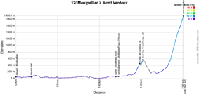
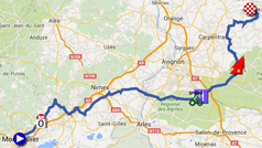
- start : Rue de la Loge in Montpellier ; the kilometer 0 will be on the D610, after 18.7 km
- climbs : Côte de Gordes (4th, 3.3 km at 4.8%) at km 131.5, Col des Trois Termes (3rd, 2.5 km at 7.5%) at km 135.5 and the Mont Ventoux (HC, 15.7 km at 8.8%) at km 184
- feeding zone : between Mollégès and Plan-d'Orgon
- intermediate sprint : D99 / Route d'Aix-en-Provence in Mollégès-Gare at km 102.5
- finish : on the Mont Ventoux after a climb of 15.7 km at 8.8%
- visited departments : Hérault (34) from km 0 till km 10.5, Gard (30) from km 13 till km 73, Bouches-du-Rhône (13) from km 77 till km 106.5, Vaucluse (84) from km 111.5 till km 184
- main cities : Montpellier, Sommières, close to Nîmes and Avignon, Mont Ventoux
13/ Friday 15 July 2016 - Bourg-Saint-Andéol > La Caverne du Pont-d'Arc - individual time trial - 37.5 km
The day after the stage finish on top of the Mont Ventoux, an individual time trial starting in Bourg-Saint-Andéol will be on the programme. This first time trial of this Tour de France 2016 could well influence the general classification with its distance of 37.5 kilometers, especially because a rider who would like to get a good time in this stage should have some climbing capabilities as well. Indeed, right from the start and up to the first intermediate timing point on top of the Côte de Bourg-Saint-Andéol the race route goes uphill over a distance of 7.5 kilometers with an average steepness of 4.5%. This will be followed by a flat part with the intermediate timing point at Les Arredons before the riders in their individual effort start the descent towards the Ardèche river. They'll then get to the intermediate timing point at the Pont d'Arc and continue along the river before getting on another uphill part in the last kilometers, up to the finish at La Caverne du Pont-d'Arc.Hereunder you'll find the time- and route schedule, the profile and the race route on Google Maps for this stage. Click on the images to open them.


- start : Avenue Félix Chalamel in Bourg-Saint-Andéol
- climbs : there are no referenced difficulties for the King of the Mountains classification; the first intermediate timing point will be on top of the Côte de Bourg-Saint-Andéol
- feeding zone : non applicable
- intermediate sprint : non applicable
- finish : La Caverne du Pont-d'Arc
- visited departments : Ardèche (07) from km 0 till km 37.5
- main cities : Bourg-Saint-Andéol, Vallon-Pont-d'Arc
14/ Saturday 16 July 2016 - Montélimar > Villars-les-Dombes Parc des Oiseaux - 208.5 km
The 14th stage, starting in Montélimar will be pretty flat and made for sprinters. The three 4th category climbs will definitely not prevent them from getting organised for a bunch finish at the Parc des Oiseaux in Villars-les-Dombes.Hereunder you'll find the time- and route schedule, the profile and the race route on Google Maps for this stage. Click on the images to open them.


- start : Avenue John Kennedy in Montélimar ; the kilometer 0 will be on the D128 5.5 km further
- climbs : Côte de Puy-Saint-Martin (4th, 3.6 km at 5.2%) at km 20.5, Côte du Four-à-Chaux (4th, 3.9 km at 4.2%) at km 93.5, Côte d'Hauterives (4th, 2.1 km at 5.5%) at km 101.5
- feeding zone : in Beaurepaire
- intermediate sprint : Route de La Fayette in La Fayette
- finish : on the D1083, at the Parc des Oiseaux in Villars-les-Dombes
- visited departments : Drôme (26) from km 0 till km 104.5, Isère (38) from km 108.5 till km 162 and from km 167 till km 175.5, Rhône (69) at km 166 and at km 180.5, Ain (01) from km 184.5 till km 208.5
- main cities : Montélimar, Crest, Romans-sur-Isère, (turning around Lyon) and Villars-les-Dombes
15/ Sunday 17 July 2016 - Bourg-en-Bresse > Culoz - 160 km
The 15th stage of the Tour de France 2016 will start in Bourg-en-Bresse and shows a much more mountaneous profile than the previous stage. Indeed, in addition to a climb of the 2nd and two climbs of the 3rd category, the riders will have to climb quite rapidly after the start of the stage a 1st category climb, the Col du Berthiand before they'll find the Grand Colombier, hors catégorie, in the last third of the stage, and they'll find this mountain once again in the circuit around the finish city, climbing the Lacets du Grand Colombier before going on back to the finish in Culoz.Hereunder you'll find the time- and route schedule, the profile and the race route on Google Maps for this stage. Click on the images to open them.

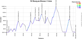
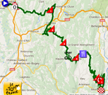
- start : Boulevard Charles de Gaulle in Bourg-en-Bresse ; the kilometer 0 on the D979 after 5.5 km
- climbs : Col du Berthiand (1st, 6 km at 8.1%) at km 23, Col du Sappel (2nd, 8.8 km at 5.6%) at km 52, Col de Pisseloup (3rd, 4.9 km at 5.8%) at km 63.5, Col de la Rochette (3rd, 5.1 km at 5.4%) at km 79, Grand Colombier (HC, 12.8 km at 6.8%) at km 113 and the Lacets du Grand Colombier (1st, 8.4 km at 7.6%) at km 146
- feeding zone : Hotonnes
- intermediate sprint : Route de Champdor in Hauteville-Lompnes at km 71.5
- finish : Avenue Jean Falconnier in Culoz
- visited departments : Ain (01) from km 0 till km 160
- main cities : Bourg-en-Bresse, Hauteville-Lompnes, Culoz
CONTINUE READING AFTER THIS ADVERTISEMENT
16/ Monday 18 July 2016 - Moirans-en-Montagne > Bern (CH) - 209 km
The 16th stage of the Tour de France 2016, starting in Moirans-en-Montagne, will leave the French territory halfway the stage to enter the Swiss territory where the stage will finish in Bern. This stage shows a profile without much difficulties but the Côte de Mühleberg (4th category) could well prevent the sprinters from battling for the stage victory!Hereunder you'll find the time- and route schedule, the profile and the race route on Google Maps for this stage. Click on the images to open them.

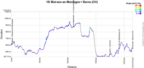
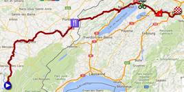
- start : Route de Saint-Laurent in Moirans-en-Montagne ; the kilometer 0 will be on the D470 after 8.4 km
- climbs : Côte de Mühleberg (4th, 1.2 km at 4.8%) at km 183.5
- feeding zone : in La Cluse-et-Mijoux
- intermediate sprint : Gampelengasse in Ins/Anet at km 167.5
- finish : Papiermühlestrasse in Bern (CH), at the Stade de Suisse Wankdorf-Bern
- visited departments : Jura (39) from km 0 till km 69, Doubs (25) from km 74 till km 104.5, Canton de Neuchâtel (CH) from km 107.5 till km 161.5, Canton de Bern (CH) from km 166.5 till km 170.5 and from km 178 till km 209, Canton de Fribourg (CH) from km 175.5 till km 176
- main cities : Moirans-en-Montagne, Champagnole, (close to Pontarlier), Neuchâtel (CH), Bern (CH)
R2/ Tuesday 19 July 2016 - Bern (CH)
After this stage, the riders will stay in Bern in Switzerland for the second rest day.17/ Wednesday 20 July 2016 - Bern (CH) > Finhaut-Emosson (CH) - 184.5 km
After this second rest day, the start of the 17th stage will also be in Bern in Switzerland and this stage will entirely take place on Swiss ground. It will be a stage for pure climbers. Indeed, going off south and after two 3rd category climbs, the Côte de Saanenmöser and the Col des Mosses, the riders will go on with the Col de la Forclaz (1st category) over 13 kilometers and the final climb towards the finish at the barrage of Finhaut-Emosson over about 10 kilometers. The Critérium du Dauphiné 2014 already had a stage finish there.Hereunder you'll find the time- and route schedule, the profile and the race route on Google Maps for this stage. Click on the images to open them.

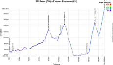

- start : close to the Papiermühlestrasse in Bern (CH)
- climbs : Côte de Saanenmöser (3rd, 6.6 km at 4.8%) at km 72.5, Col des Mosses (3rd, 6.4 km at 4.4%) at km 105, Col de la Forclaz (1st, 13 km at 7.9%) at km 166.5 and the final climb towards the barrage of Finhaut-Emosson (HC, 10.4 km at 8.4%)
- feeding zone : close to Château-d'Oex
- intermediate sprint : Rue du Léman in Martigny at km 150
- finish : on top of the climb towards the barrage of Finhaut-Emosson after a climb of 10.4 km at 8.4%
- visited departments : Canton de Bern (CH) from km 0 till km 80.5, Canton de Vaud (CH) from km 83.5 till km 132, Canton du Valais (CH) from km 136 till km 184.5
- main cities : Bern, Martigny, Finhaut
18/ Thursday 21 July 2016 - Sallanches > Megève - individual time trial - 17 km
Back in France for the 18th stage of the Tour de France 2016 this Thursday 21st of July, for an individual time trial over a distance of 17 kilometers uphill, like what we usually see as a cronoscalata in the Tour of Italy. Indeed, after about 4 kilometers flat, the riders will start the climb towards the top of the Côte de Domancy in their individual effort, where they'll find the first intermediate timing point (2.5 km at 9.4%) on top of which the Prix Bernard Hinault will be awarded to the rider who will show the fastest time in this climb.After a flatter part and the intermediate timing point in Combloux, they'll go on with the climb of the Côte des Chozeaux (3.1 km at 5.4%) and in this climb they'll reach the last intermediate timing point before the finish, in Les Berthelets. A short uphill part will be followed by the descent towards Megève where they'll cross the finish line.
Hereunder you'll find the time- and route schedule, the profile and the race route on Google Maps for this stage. Click on the images to open them.

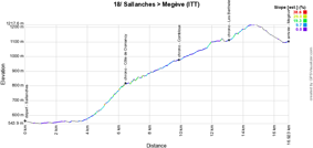

- start : Rue du Mont Blanc in Sallanches
- climbs : no climbs counting for the King of the Mountains classification, but the Côte de Domancy (2.5 km at 9.4%) at km 6.5 will award the Prix Bernard Hinault ; furthermore, the riders will climb the Côte des Chozeaux (3.1 km at 5.4%) at km 14.5
- feeding zone : none
- intermediate sprint : non applicable
- finish : Route du Palais des Sports in Megève
- visited departments : Haute-Savoie (74) from km 0 till km 17
- main cities : Sallanches, Domancy, Combloux, Demi-Quartier and Megève
CONTINUE READING AFTER THIS ADVERTISEMENT
19/ Friday 22 July 2016 - Albertville > Saint-Gervais Mont Blanc - 146 km
Further south than the previous day's time trial, the start of this 19th stage will be in Albertville and this will be a real mountain stage!Right after the start, the riders will start the climb of the Collet de Tamié (8.1 km at 7%), a non referenced climb for the King of the Mountains classification. After the sprint in Doussard and a short part alongside the lake of Annecy, they'll climb the Col de la Forclaz de Montmin of the 1st category. This climb will be followed by a visit of the valley over about twenty kilometers and they'll then climb the smaller brother of the previous climb, the Col de la Forclaz de Queige of the 2nd category. Rapidly after that they'll go on with a hors catégorie climb, the Montée de Bisanne, and after a déjà-vu on the roads in Megève and Combloux which the riders saw the day before as well, they'll start the final climb towards the Mont Blanc above Saint-Gervais with the finish at Le Bettex.
Hereunder you'll find the time- and route schedule, the profile and the race route on Google Maps for this stage. Click on the images to open them.

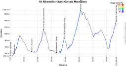
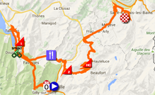
- start : Cours de l'Hôtel de Ville in Albertville ; the kilometer 0 will be on the D104A after 6.5 km
- climbs : Col de la Forclaz de Montmin (1st, 9.8 km at 6.9%) at km 42.5, Col de la Forclaz de Queige (2nd, 5.6 km at 7.8%) at km 73.5, Montée de Bisanne (HC, 12.4 km at 8.2%) at km 96.5, Le Bettex, Mont Blanc (1st, 9.8 km at 8%) at km 146 (finish)
- feeding zone : close to Ugine
- intermediate sprint : Route d'Albertville in Doussard
- finish : at Le Bettex on the Mont Blanc above Saint-Gervais after a climb of 9.8 km at 8%
- visited departments : Savoie (73) from km 0 till km 116.5, Haute-Savoie (74) from km 117.5 till km 146
- main cities : Albertville, Ugine, Combloux, Domancy and Saint-Gervais-Les-Bains
20/ Saturday 23 July 2016 - Megève > Morzine - 146.5 km
The forelast stage of the Tour de France 2016 will still be in the same area, with a start in Megève. This will be a short stage with no less than 4 difficulties following up on each other however. Rapidly after the start, the riders will start the climb of the Col des Aravis of the 2nd category and battle for the intermediate sprint after the descent, in Le Grand Bornand. Right after that they'll start the climb of the Col de la Colombière of the 1st category and after a long descent they'll get in the valley where they can get some new forces in the feeding zone in Marignier. The two most important climbs of the stage will follow, the Col de la Ramaz of the 1st category and the Col de Joux Plane (hors catégorie). The descent of the last mentioned mountain will bring the riders to the finish in Morzine.In the descent of the Col de la Ramaz, between Le Praz de Lys and Fry, at a location called La Ravine there's currently a risk for landslides on the D328 and since the situation doesn't seem to be completely certain for now (see this article of the Dauphiné newspaper which seems more alarming than the last publication from the Taninges city at the date of publication of this article), the race route of this stage might be modified before the 23rd of July. The easiest solution seems to be to go from Mieussy directly to Taninges and thus circumvent the Col de la Ramaz! Even though in theory it's also possible to turn left on the D328 from the descent on the D308 (which would mean there'd be a very sharp hairpin bend), instead of turning right as originally planned, and thus climb the Col de l'Encrenaz and the Col des Gets in order to get back on the initial race route and still be able to climb the Col de Joux Plane.
Hereunder you'll find the time- and route schedule, the profile and the race route on Google Maps for this stage. Click on the images to open them.

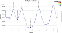

- start : Allée des Lutins in Megève ; the kilometer 0 will be on the D1212 after 2.9 km
- climbs : Col des Aravis (2nd, 6.7 km at 7%), Col de la Colombière (1st, 11.7 km at 5.8%), Col de la Ramaz (1st, 13.9 km at 7.1%) and the Col de Joux Plane (HC, 11.6 km at 8.5%)
- feeding zone : close to Marignier
- intermediate sprint : Route de Villavit in Le Grand-Bornand
- finish : Place de l'Office du Tourisme in Morzine
- visited departments : Haute-Savoie (74) from km 0 till km 1.5 and from km 25 till km 146.5, Savoie (73) from km 4 till km 21
- main cities : Megève, Saint-Jean-de-Sixt, Le Grand-Bornand, Scionzier and Marnaz close to Cluses, Mieussy, Taninges, Samoëns, Morzine
21/ Sunday 24 July 2016 - Chantilly > Paris Champs-Elysées - 113 km
The peloton will enter Paris from the west and then follow the Avenue de la Grande Armée, descend towards the Seine via the Avenue Marceau, follow the river and turn left in front of the Louvre museum and arrive on the usual 8 laps on the final circuit! (they'll cross the finish line 9 times)
Hereunder you'll find the time- and route schedule, the profile and the race route on Google Maps for this stage. Click on the images to open them.


- start : Rue du Connétable in Chantilly ; the kilometer 0 will be on the D909 after no less than 15 km of neutralised riding, via the garden of the castle (only for the race, not for the advertising caravan and the other vehicles outside of the race)
- climbs : Côte de l'Ermitage (4th at km 32.5)
- feeding zone : none
- intermediate sprint : Paris, on the Champs-Elysées at km 73.5 just after the 3rd crossing of the finish line
- finish : Avenue des Champs-Elysées in Paris, after a final straight line of 400 m, 9 m large
- visited departments : Oise (60) from km 0 till km 2.5, Val-d'Oise (95) from km 4.5 till km 37.5, Hauts-de-Seine (92) from km 38 till km 47,5, Paris (75) from km 48 till km 113
- main cities : Chantilly, Argenteuil, Colombes, Courbevoie, Suresnes, Paris
The Tour de France 2016 race route in Google Earth
Do you prefer to see the complete Tour de France 2016 race route on one single map? Or would you like to do a virtual fly-over above the race route of one or more of the stages of this 103rd edition of the Tour de France? That's of course possible, by downloading the KMZ file (a zipped KML file, because of its big size) below and opening it in Google Earth! ATTENTION - copyright: despite the fact that this KMZ file is made available for your own use, you must keep in mind that it is strictly forbidden to reproduce the contents of this KMZ file or of any other file (including the maps, profiles, KML files and others) which make up the race route of the Tour de France 2016. These contents are protected by copyright and I thus ask you to respect the huge amount of time spent on the creation of them. This protection concerns the reproduction of the maps or other elements in any way (as a map, a fly-over video of the maps or any other creation based on the contents published on velowire.com).
>> Download the race route of all stages of the Tour de France 2016 in Google Earth (KMZ file)

Vond u dit artikel interessant? Laat het uw vrienden op Facebook weten door op de buttons hieronder te klikken!
25 comments | 58540 views
this publication is published in: Tour de France | Tour de France 2016 | OpenStreetMap/Google Maps/Google Earth


 by marco1988 over