Sunday 16 October 2016 at 16h19
While we're at only two days from the presentation of the Tour de France 2017 race route, which you of course already discovered at velowire.com based on the rumours, I now offer you the opportunity to watch closer in detail the two first stages of this 104th edition of the Grande Boucle, with the first stage completely and the first part of the second stage.
The race route of the individual time trial and of the first part of the 2nd stage of the Tour de France 2017
We already knew it since November 2015 and it was confirmed one month later: the Tour de France 2017 will start in Düsseldorf in Germany, with an individual time trial and the start of the second stage, first stage in line.Let's now have a look in detail on the race route of these first stages:
CONTINUE READING AFTER THIS ADVERTISEMENT
1/ Saturday 1st of July 2017 - Düsseldorf (DE) > Düsseldorf (DE) - individual time trial - 13 km
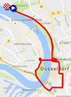
The first stage will take place in the streets of the city of Düsseldorf over a race route which mainly contains long straight lines but also some technical turns around the crossings of the Rhine river for each of the riders at the start of the Tour de France 2017. The start will take place in the Stockumer Kirchstraße and the finish in the Rotterdamer Straße at the congress center of Düsseldorf.This will be a first stage and not a prologue because the ridden distance in this solo adventure will be 13 kilometers long while the maximum distance of a prologue is 8 kilometers long.
You'll find below the profile of this first stage, a flat time trial, as well as the detailed race route on Google Maps. Click on each of the images to open them.


2/ Sunday 2 July 2017 - Düsseldorf (DE) > ???
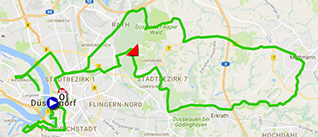
The second stage of the Tour de France 2017 will also start in the city of the Grand Départ, Düsseldorf. Officially, the destination of this stage is not known yet, but if you have had a look at the rumours about the Tour de France 2017 race route, you know very well that this stage will most logically go off directly west towards its final destination, Liège in Belgium.Well, directly west, not really actually because it has been announced that this stage will start with a loop of about fifty kilometers around Düsseldorf, east of the start city. The fictive start of this stage will take place in the city center of Düsseldorf, in the Mertensgasse, and after a zig-zag in the streets of the city, the real start will be in the Kaiserstraße, about 9 kilometers from the initial start location. After less than 10 kilometers, the first points for the King of the Mountains classification will be awarded to the rider who rides up the Grafenberg the quickest and the race will continue east towards the city Mettmann where it will turn west, back to Düsseldorf.
That's where the track on the map stops, but we know that the stage continues west and the intermediate sprint of it will be in Mönchengladbach, close to the Borussia Mönchengladbach stadium, one of the most titled football clubs of the country (the "Stadion im Borussia-Park").
You'll find below the profile of the first part of this second stage (up to the point where they come back to Düsseldorf), as well as the detailed race route on Google Maps. Click on each of the images to open them.


Please come back soon to find further details about the Tour de France 2017 race route! door Thomas Vergouwen
Vond u dit artikel interessant? Laat het uw vrienden op Facebook weten door op de buttons hieronder te klikken!
3 comments | 12211 views
this publication is published in: Tour de France | Tour de France 2017 | OpenStreetMap/Google Maps/Google Earth


 by marco1988 over
Bonjour,
Je voudrais savoir où vous trouvez ces tracés précis des étapes ?
Je souhaiterais les reproduire pour un projet perso
bonjour quand sera disponible le trace sur google map avec les zone de ravitaillements merci
Bonjour @Frederic #1, les informations sont fournies par A.S.O. mais après il faut en déduire où ça passe précisément car les itinéraires horaires et les cartes ne sont pas très précis !
@roy #2, je travaille dessus actuellement et je devrais pouvoir publier tout ça avant mon départ sur le Tour jeudi prochain, malgré mon emploi du temps très chargé ! Vous avez de la chance, mes cartes intègreront en effet les localisations des zones de ravitaillements, malgré le fait que l'information sur leur localisation n'est pas fournie à ce jour par A.S.O. dans les itinéraires horaires et malgré le fait que le livre de route n'est toujours pas publié pour la presse :-(.