As usual, velowire.com allows you to discover in detail the race route of this 107th edition of the Grande Boucle - an edition which is a bit particular in the current context related to the health crisis around the coronavirus / Covid-19, starting of course with the dates on which it takes place - on Open Street Maps/Google Earth now we're getting closer to the start of the Tour de France 2020.
With the informations in this article you'll get to know all the details, all cities and towns which are visited by the Tour and in this way you can either prepare your visit of the race if you're one of the many (but most probably lot less this year than usual) spectators on the side of the road, or simply to better understand the race if you're not there!
A little bit of initial information ...
Some first precisions before we discover in detail all stages of the Tour de France 2020:- as for any contents on velowire.com, it is strictly forbidden to reproduce (or copy/paste) any of its contents in any particular form, as indicated on the copyright page. Please do respect the huge amount of time spent on preparing contents like these!
- the stage profiles have been generated automatically based on altitude informations which are known for the places the race comes through; there can thus be some calculation errors but the global profile is correct!
- access to the feeding zones of the Tour de France 2020 is strictly forbidden to the public in the current context; these are thus not indicated on the maps or in the time- and route schedules
The programme of the Grand départ of the Tour de France 2020
Here are the dates to keep in mind for the Grand départ of the Tour de France 2020:The race route of the Tour de France 2020 on Open Street Maps
Let's now discover all details of the Tour de France 2020 race route, stage by stage :CONTINUE READING AFTER THIS ADVERTISEMENT
1/ Saturday 29 August 2020 - Nice > Nice - moyen pays - 156 km
The first stage of the Tour de France 2020 will start and finish in Nice. This stage is called "moyen pays" since it explores the country side above Nice much less north than the following, the "haut pays" stage.This stage has a quite particular format, with two loops: the riders will first go off east to the north on the short loop. Indeed, in Aspremont they'll turn left to redescend towards Nice following the Var river. Once they've done this short loop a first time and once they've crossed the finish line around 3.11PM, they'll do it for a second time and finish it off with the intermediate sprint on the finish line in Nice when they cross it for the second time around 4.20PM. It will be followed by the grand loop, where they'll go up north to Levens before they redescend via Saint-Martin-du-Var and back to the finish in Nice which should be quite late on the day, around 6PM after around 4 hours of racing.
Hereunder you'll find the time- and route schedule, the stage profile and the race route on Open Street Maps for this stage. Click on the images to open them.


- start : the start will be at Place Masséna in Nice (1.45PM), with the official start ceremony (as this is the first stage of the Tour de France 2020) on the Boulevard Jean Jaurès immediately afterwards (1.50PM till 2PM)
- difficulties and climbs : Côte de Rimiez (3rd category) at km 48,5 and at km 97 - 5,8 km à 5,1% ; this climb will be just before the km 0 of the race and the two times it counts for the King of the Mountains classification are thus in the second short loop and early in the long loop
- intermediate sprint : Promenade des Anglais in Nice at km 88 ; at the second crossing of the finish line
- finish : Promenade des Anglais in Nice at the end of a straight line of 2 km (of which 800 m in line of sight) / width 6,50 m
- visited departments : Alpes-Maritimes from km 0 till km 156
- main cities : Nice, Aspremont, Tourrette-Levens, Levens, La Roquette-sur-Var, Saint-Martin-du-Var
2/ Sunday 30 August 2020 - Nice > Nice - haut pays - 186 km
This second stage will start in Nice at the same place as the previous one, but this time it goes off west and than north. A first big loop will be the main part of the stage and this loop goes up north two times further than the big loop of the previous stage, and turns east only at Rimplas in order to include the climb of the Col de la Colmiane before the riders redescend towards Nice in Saint-Martin-Vésubie via the Col de Turini. Back in Nice and initially without crossing the finish line, there will be two shorter loops on the east side of the city of the Grand départ of the Tour de France 2020. The riders will start with the biggest one, which will bring them - via the Col des Quatre Chemins - towards the Col d'Eze before they get back on the Moyenne Corniche and to Villefranche-sur-Mer going on through to Nice. After a first crossing of the finish line, they'll go on to the shortest loop which initially follows the same roads, but once they get on the Col des Quatre Chemins - which will be the Bonus sprint in this case - they'll get on an intermediate road which directly brings them on the road back towards the finish in Nice.Hereunder you'll find the time- and route schedule, the stage profile and the race route on Open Street Maps for this stage. Click on the images to open them.


- start : the start will be at Avenue de Verdun in Nice
- difficulties and climbs : Col de la Colmiane (1st category) at km 63,5 - 16,3 km à 6,3%, Col de Turini (1st category) at km 99,5 - 14,9 km à 7,4% and Col d'Eze (2nd category) at km 153 - 7,8 km à 6,1%
- intermediate sprint : Lac du Broc at km 16
- bonus sprint : Col des Quatre Chemins at km 177
- finish : Promenade des Anglais in Nice at the end of a straight line of 2 km (of which 800 m in line of sight) / width 6,50 m
- visited departments : Alpes-Maritimes from km 0 till km 186
- main cities : Nice, Saint-Martin-Vésubie, Roquebillière, L'Escarène, La Trinité
3/ Monday 31 August 2020 - Nice > Sisteron - 198 km
The stage which ends off the Grand départ will also start in Nice, but this time it'll be to get further away towards the north west. 3 climbs of the 3rd and one of the 4th category await the riders who will follow the Route Napoléon, before they get to the finish in Sisteron. Most logically this should be a stage made for the best sprinters of the peloton.Hereunder you'll find the time- and route schedule, the stage profile and the race route on Open Street Maps for this stage. Click on the images to open them.


- start : the start will be at Allée Camille Muffat, devant l'Allianz Riviera, in Nice
- difficulties and climbs : Col du Pillon (3rd category) at km 55 - 8,4 km à 5,1%, Col de la Faye (3rd category) at km 63,5 - 5,3 km à 4,8%, Col des Lèques (3rd category) at km 117,5 - 6,9 km à 5,4% and Col de l'Orme (4th category) at km 152,5 - 2,7 km à 5%
- intermediate sprint : Boulevard Gambetta in Digne-les-Bains at km 160,5
- finish : Avenue de la Libération in Sisteron at the end of a straight line of 1000 m (of which 900 m in line of sight) / width 6 m
- visited departments : Alpes-Maritimes from km 0 till km 88 and at km 90,5, Var at km 90,5 and at km 96, Alpes-de-Haute-Provence at km 93 and from km 98 till km 198
- main cities : Nice, Vence, Grasse, Digne-les-Bains, Sisteron
4/ Tuesday 1 September 2020 - Sisteron > Orcières-Merlette - 160,5 km
The start of the next day's stage will also be in Sisteron and will visit the Dévoluy mountain area where the riders will find 4 climbs of the 3rd and 4th category before the first mountain top finish of this Tour de France which does comes quite early in this stage race. In Orcières-Merlette the riders will get to an altitude of 1825 meters and even though we will probably not see big time gaps in the general classification after this stage, it will definitely give us an idea of the shape of the main favourites of this Tour !Hereunder you'll find the time- and route schedule, the stage profile and the race route on Open Street Maps for this stage. Click on the images to open them.

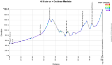

- start : the start will be at Rue de la Poste in Sisteron
- difficulties and climbs : Col du Festre (3rd category) at km 67,5 - 7,6 km à 5,3%, Côte de Corps (4th category) at km 97,5 - 2,2 km à 6,3%, Côte de Saint-Léger-les-Mélèzes (3rd category) at km 141 - 2,8 km à 6,8% and Orcières-Merlette (1st category) at km 160,5 - 7,1 km à 6,7%
- intermediate sprint : Route de Gap in Veynes at km 51,5
- finish : Rue des Écrins in Orcières-Merlette at the end of a straight line of 200 m / width 6 m
- visited departments : Alpes-de-Hautes-Provence for the fictive start, Hautes-Alpes from km 0 till km 84 and from km 103 till km 160,5, Isère from km 84,5 till km 97,5
- main cities : Sisteron, Laragne-Montéglin, Serres, Veynes, Dévoluy, Corps, Aubessagne, Saint-Bonnet-en-Champsaur, Saint-Julien-en-Champsaur, Chabottes, Orcières
CONTINUE READING AFTER THIS ADVERTISEMENT
5/ Wednesday 2 September 2020 - Gap > Privas - 183 km
Not far from the previous stage finish, the riders will start in Gap for the 5th stage and it will pretty much go downhill. The two 4th category difficulties will probably not prevent the sprinters from battling for the victory at the finish, but the final part which is slightly going uphill might make it a stage for the strongest guys amongst them!Hereunder you'll find the time- and route schedule, the stage profile and the race route on Open Street Maps for this stage. Click on the images to open them.

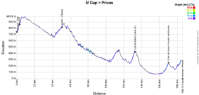

- start : the start will be at Rue Fauré du Serre in Gap
- difficulties and climbs : Col de Serre Colon (4th category) at km 130 - 4,1 km à 3,7% and Côte de Saint-Vincent-de-Barrès at km 167 - 2,7 km à 4,2%
- intermediate sprint : D994 in L'Épine at km 47,5
- finish : Boulevard du Vivarais in Privas at the end of a straight line of 250 m / width 6 m
- visited departments : Hautes-Alpes from km 0 till km 61, Drôme from km 66 till km 151, Ardèche from km 152,5 till km 183
- main cities : Gap, Veynes, Serres, Nyons, Montélimar, Privas
6/ Thursday 3 September 2020 - Le Teil > Mont Aigoual - 191 km
Close to Montélimar, the riders will come back together in Le Teil on this Thursday 3 September for the start of the 6th stage of the Tour de France 2020 with a quite rich final part. Indeed, even though the stage starts with only two 3rd category difficulties, the second one is indeed the first step towards the Col de la Lusette, much steeper and of the 1st category, followed by the Mont Aigoual where the finish of this stage will be.Hereunder you'll find the time- and route schedule, the stage profile and the race route on Open Street Maps for this stage. Click on the images to open them.

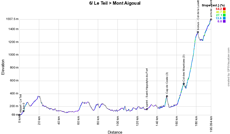

- start : the start will be at Allée Paul Avon in Le Teil
- difficulties and climbs : Cap de Coste (3rd category) at km 146 - 2,1 km à 7,3%, Col des Mourèzes at km 163 - 6,1 km à 4,8% and Col de la Lusette at km 177,5 - 11,7 km à 7,3%
- intermediate sprint : Faubourg de Mandiargues in Saint-Hippolyte-du-Fort at km 125,5
- bonus sprint : Col de la Lusette at km 177,5
- finish : D269 on the Mont Aigoual at the end of a straight line of 100 m / width 5 m
- visited departments : Ardèche from km 0 till km 62, Gard from km 64,5 till km 130,5 and from km 142,5 till km 186,5 and at km 191, Hérault from km 136,5 till km 138, Lozère at km 190
- main cities : Le Teil, Villeneuve-de-Berg, Alès, Anduze, Sumène, Le Vigan, Mont Aigoual
7/ Friday 4 September 2020 - Millau > Lavaur - 168 km
The 7th stage will start in Millau which is definitely not at its first try with the Tour de France and of which its famous viaduct always makes a beautiful back setting for a stage start. This will be a slightly hilly stage towards Lavaur (which receives the Tour for the 3rd time as well already), and this stage's difficulty might potentially be in the wind which can lead to some breakups in the peloton.Hereunder you'll find the time- and route schedule, the stage profile and the race route on Open Street Maps for this stage. Click on the images to open them.

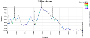

- start : the start will be at Avenue du Général de Gaulle in Millau
- difficulties and climbs : Côte de Luzençon (3rd category) at km 9 - 3,1 km à 6,1%
- intermediate sprint : Route de Saint-Affrique in Saint-Sernin-sur-Rance at km 58
- finish : D112/Avenue Pierre Fabre in Lavaur at the end of a straight line of 2 km (of which 450 m in line of sight) / width 6 m
- visited departments : Aveyron from km 0 till km 73,5, Tarn from km 80,5 till km 168
- main cities : Millau, Saint-Affrique, Montredon-Labessonnié, Roquecourbe, Castres, Lavaur
8/ Saturday 5 September 2020 - Cazères-sur-Garonne > Loudenvielle - 141 km
The first Pyrenean stage will start in Cazères-sur-Garonne, south-west of Toulouse, and even though the first 40 kilometers are quite flat, the 100 following kilometers will be explosive with first the Col de Menté of the 1st category, followed by the Port de Balès which is an outside category climb and finally the Col de Peyresourde of the 1st category which precedes the drop to the valley where the finish is, in Loudenvielle.Hereunder you'll find the time- and route schedule, the stage profile and the race route on Open Street Maps for this stage. Click on the images to open them.

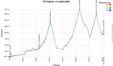

- start : the start will be at Pont sur la Garonne in Cazères-sur-Garonne
- difficulties and climbs : Col de Menté (1st category) at km 59,5 - 6,9 km à 8,1%, Port de Balès (outside category) at km 104,5 - 11,7 km à 7,7% and Col de Peyresourde (1st category) at km 129,5 - 9,7 km à 7,8%
- intermediate sprint : D5 in Sengouagnet at km 42,5
- bonus sprint : Col de Peyresourde
- finish : Le Rioutor in Loudenvielle at the end of a straight line of 300 m (of which 160 m in line of sight) / width 6 m
- visited departments : Haute-Garonne from km 0 till km 76,5 and from km 110,5 till km 129,5, Haute-Pyrénées from km 77,5 till km 104,5 and from km 135 till km 141
- main cities : Cazères-sur-Garonne, Salies-du-Salat, Mane, Aspet, Saint-Béat, Cierp-Gaud, Loudenvielle
CONTINUE READING AFTER THIS ADVERTISEMENT
9/ Sunday 6 September 2020 - Pau > Laruns - 153 km
The second and last Pyrenean stage will entirely take place in the Pyrénées-Atlantiques (64) department and offers a menu which is a bit less hard than the previous stage but which leads the riders to the Col de la Hourcère in the first half of the stage and the Col de Marie Blanque close to the finish (both of the 1st category).Hereunder you'll find the time- and route schedule, the stage profile and the race route on Open Street Maps for this stage. Click on the images to open them.

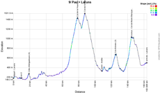
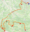
- start : the start will be at Avenue Gaston Lacoste in Pau
- difficulties and climbs : Côte d'Artiguelouve (4th category) at km 9,5 - 2,3 km à 4,5%, Col de la Hourcère (1st category) at km 69 - 11,1 km à 8,8%, Col de Soudet (3rd category) at km 78 - 3,8 km à 8,5%, Col d'Ichère (3rd category) at km 115,5 - 4,2 km à 7% and Col de Marie Blanque (1st category) at km 135 - 7,7 km à 8,6%
- intermediate sprint : Avenue Marcel Loubens in Arette at km 99
- bonus sprint : Col de Marie Blanque
- finish : D934 in Laruns at the end of a straight line of 3,4 km (of which 800 m in line of sight) / width 5,50 m
- visited departments : Pyrénées-Atlantiques from km 0 till km 153
- main cities : Pau, Artiguelouve, Lasseube, Oloron Saint-Marie, Aramits, Arette, Bielle, Laruns
R1/ Monday 7 September 2020 - rest day in Charente-Maritime
After a transfer of 430 kilometers (initially planned to be done by plane for the riders, it should take place by bus in the end), the riders can get some rest, after a first week which was quite fully packed, in the Charente-Maritime.10/ Tuesday 8 September 2020 - Île d'Oléron > Île de Ré - 168,5 km
After the rest day a quite original stage is on the programme of the Tour de France 2020, since it will take place between two islands.While the Île d'Oléron already had a stage finish, it'll this time be the start location of this stage which is exposed to the wind, at the Le Château d'Oléron. After a stage following the coast down to Royan, going in the swamp areas towards Rochefort before they get back to the coast up to La Rochelle and the bridge towards the Île de Ré where the finish will be in Saint-Martin-de-Ré.
Hereunder you'll find the time- and route schedule, the stage profile and the race route on Open Street Maps for this stage. Click on the images to open them.


- start : the start will be at Avenue de la Citadelle in Le Château d'Oléron sur l'Île d'Oléron
- difficulties and climbs : none
- intermediate sprint : Boulevard de Lattre de Tassigny in Châtelaillon-Plage at km 129,5
- finish : D735 in Saint-Martin-de-Ré on the Île-de-Ré at the end of a straight line of 2 km (of which 300 m in line of sight) / width 6 m
- visited departments : Charente-Maritime from km 0 till km 168,5
- main cities : Le Château-d'Oléron, Royan, Marennes, Rochefort, La Rochelle, Saint-Martin-de-Ré
11/ Wednesday 9 September 2020 - Châtelaillon-Plage > Poitiers - 167,5 km
Starting on the sea side, in Châtelaillon-Plage, the dream of its mayor - Stephane Villain - becomes truth, to get the Tour back in the Poitou-Charentes area but most importantly in his city.This stage will be completely flat and with the finish in Poitiers, which Christian Prudhomme - the director of the Tour de France - qualified as one of the most beautiful straight lines of the Grande Boucle 2020, we'll most probably see a sprint finish.
Hereunder you'll find the time- and route schedule, the stage profile and the race route on Open Street Maps for this stage. Click on the images to open them.


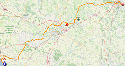
- start : the start will be at Hippodrome du Haut-Rillon in Châtelaillon-Plage
- difficulties and climbs : Côte de Cherveux (4th category) at km 91 - 1,1 km à 4,4%
- intermediate sprint : Les Grands Ajoncs in Exireuil at km 108
- finish : Avenue John Fitzgerald Kennedy in Poitiers at the end of a straight line of 1,6 km (of which 1,2 km à line of sight) / width 7,50 m
- visited departments : Charente-Maritime from km 0 till km 39, Deux-Sèvres from km 41 till km 128,5, Vienne from km 135 till km 167,5
- main cities : Châtelaillon-Plage, Saint-Maixent-l'Ecole, Poitiers
CONTINUE READING AFTER THIS ADVERTISEMENT
12/ Thursday 10 September 2020 - Chauvigny > Sarran - 218 km
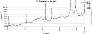
In the medieval city of Chauvigny where the start of the Vienne Classic Espoirs takes place every year, it'll this time be the start of the 12th stage of the Tour de France 2020 which will be on the programme this Thursday 10 September. It'll be the longest stage of this Tour which starts of with 3 difficulties of the 4th and 3rd category before the riders go on to the final part, with all these kilometers in their legs already, with the climb of the Suc au May of the 2nd category. The rider who arrives first on top of this climb not only takes the points for the King of the Mountains classification but also wins the bonus of this stage.After the inevitable tribute in Saint-Léonard-de-Noblat to Raymond Poulidor who is no longer among us but who elected this as his adoption city, the finish location of the stage - Sarran, the smallest town of the Tour de France 2020 with only 260 inhabitants - will be where a tribute can be paid to Jacques Chirac who chose to live here and who got the Tour de France here in 2001 for a stage coming from Castelsarrasin which was won by Jens Voigt.
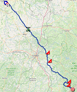
Hereunder you'll find the time- and route schedule, the stage profile and the race route on Open Street Maps for this stage. Click on the images to open them.

- start : the start will be at Rue du Marché in Chauvigny
- difficulties and climbs : Côte de Saint-Martin-Terressus (4th category) at km 104,5 - 1,5 km à 8,8%, Côte d'Eybouleuf (4th category) at km 121,5 - 2,8 km à 5,2%, Côte de la Croix du Pey (3rd category) at km 177,5 and Suc au May (2nd category) at km 192,5 - 3,8 km à 7,7%
- intermediate sprint : Place du Champ de Foire in Le Dorat at km 51
- bonus sprint : Suc au May
- finish : D142/Route du Musée in Sarran at the end of a straight line of 1,1 km (of which 200 m in line of sight) / width 5,50 m
- visited departments : Vienne from km 0 till km 39,5, Haute-Vienne from km 41,5 till km 152, Corrèze from km 158,5 till km 218
- main cities : Chauvigny, Montmorillon, Lathus-Saint-Rémy, Le Dorat, Ambazac, Saint-Léonard-de-Noblat, Treignac, Sarran
13/ Friday 11 September 2020 - Châtel-Guyon > Puy Mary - 191,5 km
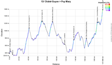
Avec a start north of Clermont-Ferrand, in Châtel-Guyon, the riders will cross the Massif central mountain area, with a never before visited finish on the Puy Mary, after having climbed the Pas de Peyrol, which itself is preceded by the climb of the Col de Neronne which shows an average steepness of no less than 9.1%.Hereunder you'll find the time- and route schedule, the stage profile and the race route on Open Street Maps for this stage. Click on the images to open them.


- start : the start will be at Avenue de l'Europe in Châtel-Guyon
- difficulties and climbs : Col de Ceyssat (1st category) at km 36 - 10,2 km à 6,1%, Col de Guéry (3rd category) at km 63,5 - 7,8 km à 5%, Montée de la Stèle (2nd category) at km 85,5 - 6,8 km à 5,7%, Côte de l'Estiade (3rd category) at km 130,5 - 3,7 km à 6,9%, Côte d'Anglards-de-Salers (3rd category) at km 153,5 - 3,5 km à 6,9%, Col de Neronne (2nd category) at km 180,5 - 3,8 km à 9,1% and Puy Mary Pas de Peyrol (1st category) at km 191,5 - 5,4 km à 8,1%
- intermediate sprint : Rue du Péage in Lanobre at km 111
- finish : D680 in Puy Mary at the end of a straight line of 300 m in line of sight / width 5 m
- visited departments : Puy-de-Dôme from km 0 till km 104, Cantal from km 108 till km 115,5 and from km 122,5 till km 191,5, Corrèze from km 116,5 till km 119,5
- main cities : Châtel-Guyon, Riom, Clermont-Ferrand, Chamalières, Royat, Le Mont-Dore, La Bourboule, Bort-les-Orgues, Saignes, Trizac, Puy Mary
14/ Saturday 12 September 2020 - Clermont-Ferrand > Lyon - 194 km
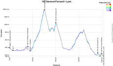
The 14th stage will start in Clermont-Ferrand and will go from west to east, with 5 difficulties, of which mainly two climbs of the 4th category just before the finish in Lyon and before that the most important climb will be the Col du Béal of the 2nd category.Hereunder you'll find the time- and route schedule, the stage profile and the race route on Open Street Maps for this stage. Click on the images to open them.


- start : the start will be at Boulevard Desaix in Clermont-Ferrand
- difficulties and climbs : Côte du château d'Aulteribe (4th category) at km 32 - 1 km à 8,4%, Col du Béal (2nd category) at km 68,5 - 10,2 km à 5,6%, Côte de Courreau at km 93 - 4 km à 5,7%, Côte de la Duchère at km 184,5 - 1,4 km à 5,6% and Côte de la Croix-Rousse (4th category) at km 189,5 - 1,4 km à 4,8%
- intermediate sprint : Avenue Henri Pourrat in Courpière at km 38
- finish : Quai Jean Moulin in Lyon at the end of a straight line of 1,8 km / width 6,50 m
- visited departments : Puy-de-Dôme from km 0 till km 69, Loire from km 74,5 till km 136, Rhône from km 138,5 till km 194
- main cities : Clermont-Ferrand, Pont-du-Château, Montbrison, Tassin-la-Demi-Lune, Lyon
15/ Sunday 13 September 2020 - Lyon > Grand Colombier - 174,5 km
From Lyon, the riders will go eastwards and thus towards the Jura and more precisely to the final climb of the Grand Colombier (outside category climb). Before they get there, the riders will have explored the Grand Colombier mountain area from different sides: starting on the west side with the Montée de la Selle de Fromentel (1st category) followed by the north side with the Col de la Biche (1st category).Hereunder you'll find the time- and route schedule, the stage profile and the race route on Open Street Maps for this stage. Click on the images to open them.

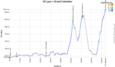
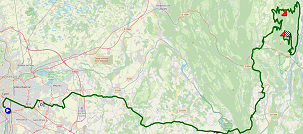
- start : the start will be at Avenue Jean Jaurès in Lyon
- difficulties and climbs : Montée de la Selle de Fromentel (1st category) at km 111 - 11,1 km à 8,1%, Col de la Biche (1st category) at km 129 - 6,9 km à 8,9% and Grand Colombier (outside category) at km 174,5 - 17,4 km à 7,1%
- intermediate sprint : Route d'Argent in Le Bouchage at km 58
- finish : D120 on the Grand Colombier at the end of a straight line of 800 m (of which 30 m in line of sight) / width 5 m
- visited departments : Rhône from km 0 till km 13, Isère from km 17,5 till km 59,5, Ain from km 62,5 till km 174,5
- main cities : Lyon, Bron, Genas, Pont-de-Chéruy, Crémieu, Morestel, Belley, Culoz, Grand Colombier
CONTINUE READING AFTER THIS ADVERTISEMENT
R2/ Monday 14 September 2020 - rest day in Isère
After this second week of stages among which several quite montaineous again,, the riders can get some rest in the Isère, before they'll start the last week which will also be quite difficult from time to time!16/ Tuesday 15 September 2020 - La Tour-du-Pin > Villard-de-Lans - 164 km
The 16th stage will again be a difficult one, starting in La Tour-du-Pin the riders will indeed go explore the Chartreuse area and the Vercors area, turning around the city of Grenoble. Approaching the finish line in Villard-de-Lans the most difficult climb of this stage will show up in front of them: the Montée de Saint-Nizier-du-Moucherotte (1st category), which will also be the point of the bonus sprint for this stage.Hereunder you'll find the time- and route schedule, the stage profile and the race route on Open Street Maps for this stage. Click on the images to open them.

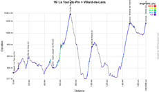

- start : the start will be at Rue du 11 Novembre 1918 in La Tour-du-Pin
- difficulties and climbs : Côte de Virieu (4th category) at km 12,5 - 2,3 km à 6,8%, Col de Porte (2nd category) at km 66,5 - 7,4 km à 6,8%, Côte de Revel (2nd category) at km 94,5 - 6 km à 8%, Montée de Saint-Dizier-du-Moucherotte (1st category) at km 143,5 - 11,1 km à 6,5% and Villard-de-Lans - Côte 2000 (3rd category) at km 164 - 2,2 km à 6,5%
- intermediate sprint : D520 in Saint-Joseph-de-Rivière at km 44,5
- bonus sprint : Montée de Saint-Dizier-du-Moucherotte
- finish : Côte 2000 in Villard-de-Lans at the end of a straight line of 150 m (of which 50 m in line of sight) / width 5,50 m
- visited departments : Isère from km 0 till km 164
- main cities : La Tour-du-Pin, Voiron, Saint-Laurent-du-pont, Meylan, Domène, Vizille, Le Pont-de-Claix, Claix, Seyssins, Villard-de-Lans
17/ Wednesday 16 September 2020 - Grenoble > Méribel - Col de la Loze - 170 km
While the first half of the stage starting in Grenoble doesn't show any particular difficulties, the second half of the stage shows two outside category climbs! The first difficulty will be the Col de la Madeleine which has its top at 2000 meters and after the descent of this col, the final climb towards Méribel and the Col de la Loze will already be awaiting the riders. This brand new climb, a paradise for cyclists, with a route which was specifically created for cyclists only all year long (the climb is forbidden with a car), will be the rooftop of the Tour de France and it'll thus be on its summit at 2304 meters of altitude that the Souvenir Henri Desgrange will be awarded. This'll be an irregular climb with several parts exceeding a 20 % steepness.Hereunder you'll find the time- and route schedule, the stage profile and the race route on Open Street Maps for this stage. Click on the images to open them.

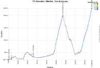
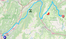
- start : the start will be at Boulevard Clémenceau in Grenoble
- difficulties and climbs : Col de la Madeleine (outside category) at km 107,5 - 17,1 km à 8,4%, Méribel - Col de la Loze (outside category) at km 170 - 21,5 km à 7,8%
- intermediate sprint : Avenue des Alpes in La Rochette at km 45,5
- finish : Route du Col de la Loze in Méribel at the end of a straight line of 2 km in line of sight) / width 4 m
- visited departments : Isère from km 0 till km 34,5, Savoie from km 42,5 till km 170
- main cities : Grenoble, Goncelin, Allevard, Saint-François-Longchamp, Moûtiers, Méribel
18/ Wednesday 17 September 2020 - Méribel > La Roche-sur-Foron - 175 km
A quite heavy programme of difficulties is planned for the stage starting in Méribel. The kilometer zero of this stage will only be after 21.5 kilometers of a neutralised track. It is extremely rare that the distance between the fictive start and the kilometer zero is so important, but this is logical here due to the fact that all the way down from Méribel to the kilometer zero the road is descending and it would of course be impossible to have a running start in a descent because this would definitely lead to accidents.After the kilometer zero, there will be no less than 5 difficulties on the programme of this stage, including the magnificent Cormet de Roselend (1st category), the Col des Aravis (1st category) and the Montée du plateau des Glières (outside category), including a 1800 meters long gravel part. After the Col des Fleuries, which is not part of the King of the Mountains classification, the riders will continue downwards towards the finish line in La Roche-sur-Foron.
Hereunder you'll find the time- and route schedule, the stage profile and the race route on Open Street Maps for this stage. Click on the images to open them.

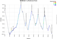

- start : the start will be at sur la Piste de l'Altiport de Méribel
- difficulties and climbs : Cormet de Roselend (1st category) at km 46 - 18,6 km à 6,1%, Côte de la route des Villes (3rd category) at km 64,5 - 3,2 km à 6,6%, Col des Saisies (2nd category) at km 91 - 14,6 km à 6,4%, Col des Aravis (1st category) at km 117,5 - 6,7 km à 7% and Montée du plateau des Glières (outside category) at km 143,5 - 6 km à 11,2%
- intermediate sprint : Avenue de la Tarentaise in Aime at km 14
- bonus sprint : Montée du plateau des Glières
- finish : D1203/Boulevard du Maquis des Glières in La Roche-sur-Foron at the end of a straight line of 500 m going uphill / width 6,50 m
- visited departments : Savoie from km 0 till km 117,5, Haute-Savoie from km 121,5 till km 175
- main cities : Méribel, Moûtiers, Aime-La Plagne, Bourg-Saint-Maurice Les Arcs, Beaufort, La Clusaz, Glières Val-de-Borne, Fillière, La Roche-sur-Foron
CONTINUE READING AFTER THIS ADVERTISEMENT
19/ Thursday 18 September 2020 - Bourg-en-Bresse > Champagnole - 166,5 km
For the sprinters who have managed to survive the Alps visit, this will be a new opportunity for a stage victory - among the rare opportunities for them during this Tour - in this 19th stage starting in Bourg-en-Bresse. The only difficulty of the 4th category will probably not prevent them to battle for the stage victory but they should pay attention all along, if they want to be part of those who can battle for victory!Hereunder you'll find the time- and route schedule, the stage profile and the race route on Open Street Maps for this stage. Click on the images to open them.

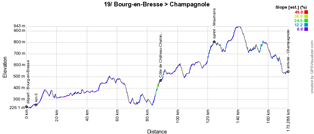
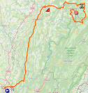
- start : the start will be at Boulevard Charles de Gaulle in Bourg-en-Bresse
- difficulties and climbs : Côte de Château-Chalon (4th category) at km 82 - 4,3 km à 4,7%
- intermediate sprint : Grande Rue in Mournans at km 117,5
- finish : Rue Léon Blum in Champagnole at the end of a straight line of 1,1 km (of which 350 m in line of sight) / width 5,50 m
- visited departments : Ain from km 0 till km 20,5, Jura from km 23,5 till km 166,5
- main cities : Bourg-en-Bresse, Nivigne-et-Suran, Lons-le-Saunier, Champagnole
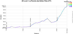
20/ Thursday 19 September 2020 - Lure > La Planche des Belles Filles - individual time trial - 36,2 km
After a transfer of about 150 kilometers, the forelast stage will be -as often in the Tour de France- an individual time trial and this time it'll take place in the cradle of Thibaut Pinot (who was born in Lure and whose father is the Mayor of Mélisey which is part of the race route of this time trial), with a start in Lure. La Planche des Belles Filles has now become a usual climb in the Tour de France, because it'll be on the programme for the 5th time since 2012, but never before it has been used to measure an individual effort! This time trial could well come modify the general classification of this race, the day before the finish in Paris!Hereunder you'll find the time- and route schedule, the stage profile and the race route on Open Street Maps for this stage. Click on the images to open them.

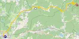
- start : the start will be at Esplanade Charles de Gaulle in Lure
- difficulties and climbs : La Planche des Belles Filles (1st category) at km 36,2 - 5,9 km à 8,5%
- intermediate sprint : not applicable
- finish : D16E in La Planche des Belles Filles at the end of a straight line of 400 m (of which 100 m in line of sight) / width 5 m
- visited departments : Haute-Saône from km 0 till km 36,2
- main cities : Lure, Saint-Germain, Mélisey, Belonchamp, Fresse, Plancher les Mines, La Planche des Belles Filles
21/ Thursday 20 September 2020 - Mantes-la-Jolie > Paris Champs-Elysées - 122 km
Again after a transfer by bus (the health situation with the coronavirus prevents the riders from taking the plane for the transfers of this Tour), it'll be the last stage of the Tour de France which will take place this Sunday 20 September 2020.Starting in the Yvelines department, as will be the case untill 2023, Mantes-la-Jolie will have the role of host city for the start of the very last stage of this Tour de France 2020 which will end in Paris on its famous Champs-Elysées. This stage will go alongside the Sénat and will again, just like last year, visit the Cour carrée du Louvre to end up on the Champs-Elysées, turn around the Arc de Triomphe as has been the case every year since 2013 and the usual 8 laps on the circuit via the Rue de Rivoli and the final sprint on the Champs.
Hereunder you'll find the time- and route schedule, the stage profile and the race route on Open Street Maps for this stage. Click on the images to open them.


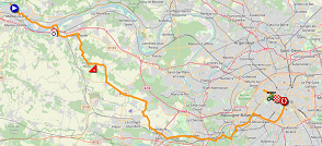
- start : the start will be at Voie de Berge in Mantes-la-Jolie
- difficulties and climbs : Côte de Beulle (4th category) at km 11,5 - 2,3 km à 3,6%
- intermediate sprint : Champs-Elysées in Paris at km 82
- finish : Champs-Elysées in Paris at the end of a straight line of 400 m / width 9 m
- visited departments : Yvelines from km 0 till km 44, Hauts-de-Seine from km 46 till km 53,5, Paris from km 56 till km 122
- main cities : Mantes-la-Jolie, Versailles, Paris
The race route of the Tour de France 2020 in Google Earth
Do you prefer to see the whole race route of the Tour de France 2020 on a single map? Or would you like to do a virtual fly-over above the race route of one or several stages of this 107th edition of the Tour de France? That's all possible, by downloading the KMZ file (a zipped KML file, due to its big size) hereunder and opening it in Google Earth (attention: please make sure you use the "desktop" version of Google Earth; if you open it in Google Earth in your navigator, it won't work correctly)! WARNING - copyright: despite the furniture of this KMZ/KML file for your own use, please note it is stricly forbidden to reproduce the contents of this KMZ/KML file or of any other file (including the maps, the profiles, the KML files and others) which make up the race route of the Tour de France 2020. These contents are indeed protected by the copyright and I'd like to ask you to pay respect to the huge amount of time it takes to create such contents. This protection thus concerns the reproduction of the maps and other elements in any kind of form (as a map, a video which flies over the maps or any other creation based on the contents as published on velowire.com).
>> Download the race route of all stages of the Tour de France 2020 in Google Earth (KMZ file)

Vond u dit artikel interessant? Laat het uw vrienden op Facebook weten door op de buttons hieronder te klikken!
14 comments | 40462 views
this publication is published in: Tour de France | Tour de France 2020 | OpenStreetMap/Google Maps/Google Earth


 by marco1988 over
- opening of the Fan Park between 2PM and 6PM - Promenade du Paillon, indicated on the map hereunder with the icon
- from 6.30PM till 8PM (free entrance after an obligatory registration and and a ballot, see more informations here: only 500 people can assist and they had to register through an online form before 23 August midnight): teams presentation of the Tour de France 2020 on the Place Masséna in Nice
An itinerary of 1.5 km on their bike allows the riders to access to the presentation on the Place Masséna and come back to the Promenade des Anglais after that. If you're not one of the 500 happy people to be able to assist to the presentation in front of the podium on the Place Masséna, you can thus possibly go see the riders of the Tour on the track of this itinerary which you can see with all necessary informations on the map below.