Friday 16 April 2010 at 00h55
This Sunday the Dutch classic, the Amstel Gold Race, will take place between Maastricht and the Cauberg in Valkenburg.
The Amstel Gold Race 2010 route has been slightly modified a bit over a week before the race, close to Eys, and the riders will now climb the Eyserbosweg twice instead of once. In this article you'll find the route and time schedule, the route on Google Maps and you can download the route in Google Earth to make virtual fly-over for example.
The Amstel Gold Race 2010 route on Google Maps
You probably know now that www.velowire.com regularly proposes the route of different cycling races on Google Maps/Google Earth. This was however not the case for the Dutch UCI ProTour race, but thanks to a file published by the Stichting Amstel Gold Race which I completed with additional information, this has now been corrected.CONTINUE READING AFTER THIS ADVERTISEMENT
The description of the race route
After the start from the Markt in Maastricht the riders will first go north via the Maasberg up to Urmond where they'll cross-over to Geleen before doing the successive climbs of the Adsteeg, Lange Raarberg, Bergseweg, Sibbergrubbe, Cauberg, Wolfsberg, Loorberg, Schweiberg (Schweibergerweg), Camerig, Drielandenpunt, Gemmenich, Vijlenerbos, Eperheide, Gulperberg, Plettenberg (van Plettenbergweg), Eyserbosweg, Sint Remigiusstraat - Huls, Vrakelberg, Sibbergrubbe for the 2nd time, the Cauberg for the 2nd time, Geulhemmerberg, Bemelerberg, the Wolfsberg for the 2nd time, the Loorberg for the 2nd time, the Gulperberg for the 2nd time, Kruisberg, the Eyserbosweg for the 2nd time, Fromberg, Keutenberg and finally the third and last climb of the Cauberg where they'll find the finish line.In the over 257 kilometers the riders can get some new energy twice in the feeding zones on the Partijerweg in Partij (after about 105 kilometers) and on the Rijksweg in Vilt at about 75 kilometers from the finish.
Usually the riders climb the Eyserbosweg only once, at about 20 kilometers from the finish. That will also be the case in this 45th edition, but due to road works in Eys they will climb the short but steep climb about 70 kilometers earlier as well. The organisor explains on the Amstel Gold Race web site that the connection Grachtstraat/Eyserweg is closed (...) and that the riders will thus go via the Eyserbosweg to Trintelen, where they'll find the usual route via la Hamerstraat towards Bosschenhuizen and Simpelveld.
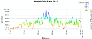
The route and time schedule, the stage profile and the route on Google Maps
Below you'll find the route on Google Maps, the profile and the route and time schedule (with the times the races will go through the different cities and villages on the route) of the Amstel Gold Race 2010. Click on each of the images to open them:


CONTINUE READING AFTER THIS ADVERTISEMENT
The Amstel Gold Race 2010 route in Google Earth
Would you prefer to view the route in Google Earth and thus be able for example to make a virtual fly-over over the route? Download the KML file below to do so:> Download the Amstel Gold Race 2010 route in Google Earth
This file will not only allow you to visualise the whole route in Google Earth but also to do a virtual fly-over over the route. To do so, you can of course use the default configuration for Google Earth, but if you would like to do a virtual fly-over as if you were riding on the roads of the Amstel Gold Race 2010, I would recommend the following settings: in the menu Tools > Options choose the tab Touring and fill in the following choices on that tab:
- Camera tilt angle : 80.0 degrees
- Camera range : 150.0 meters
- Speed : 500.0 (if this makes you feel dizzy or if your computer or Internet connection don't allow you to get clear images with these settings, you can try lowering the speed)
The Amstel Gold Race 2010 programme
As usual since a few years, all cycling fans can participate on Saturday 17 April 2010 in the Amstel Gold Race cyclo-tour version. The organisation allows you to choose between a 250, 200, 150, 125, 100 and 65 kilometers distance and the first riders will start at 6.30AM.On Sunday 18 April 2010 the Amstel Gold Race for the professionals is planned. It will be preceded by the teams presentation which will start at 9.15AM, while the race will start from the Markt in Maastricht one hour later.
Last year the Amstel Gold Race was won by Sergei Ivanov and he will thus be at the start with his Team Katusha with number 1. Who will be the Amstel Gold Race 2010 winner? door Thomas Vergouwen
Vond u dit artikel interessant? Laat het uw vrienden op Facebook weten door op de buttons hieronder te klikken!
2 comments | 12813 views
this publication is published in: Classics | UCI ProTour


 by marco1988 over
http://www.cyclisme-roltiss-over.com/article-le-parcours-de-l-amstel-gold-race-2010-sur-google-maps-google-earth-et-l-itineraire-horaire-48748519.html
JULLIE ZIJN SUPER