In a few days, the Tour Down Under will start in South-Australia, in Prospect to be more precise. 758.5 kilometers further, in Adelaide, we'll know who will be the winner of the first race of the UCI WorldTour 2013.
This will all, as usual, be preceded by the Down Under Classic, now called People's Choice Classic, which is not officially part of the Tour Down Under but which is part of the official UCI criterium calendar which thus allows the riders of the UCI ProTeams to participate.
In this article you'll find all information about the race route of the Tour Down Under 2013 including most importantly Google Maps/Google Earth maps of it and the profiles of each of the stages.
The Tour Down Under 2013 will take place from Tuesday 22 till Sunday 27 January 2013 and is since several years now the first race of the UCI WorldTour, thus preceding Paris-Nice which will as usual take place in March.
The Tour Down Under 2013 race route on Google Maps
Let's check out the different stages one by one ...CONTINUE READING AFTER THIS ADVERTISEMENT
Sunday 20 January 2013 - People's Choice Classic - 51 km
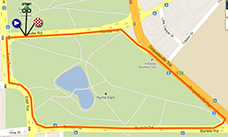
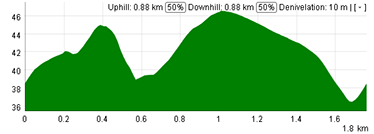
Everything will start with the People's Choice Classic which is thus not officially part of the Tour Down Under as a UCI WorldTour event but which is a UCI sanctioned criterium.As usual, a closed circuit of 1.7 kilometers around Rymill Park will form the completely flat race route for this Down Under Classic. The riders will do 30 laps on this circuit which means they'll get to a total distance of 51 kilometers. The start of the race will be at 7PM for an expected finish around 8PM.
At the 5th, 10th, 15th and 20th crossing of the finish line, the riders can take additional primes in a sprint.
Hereunder you'll find the race route of the Down Under Classic on Google Maps and its profile. Click on the images to open them.
Tuesday 22 January 2013 - 1/ Prospect > Lobethal - 135 km
The first stage of the Tour Down Under 2013 will start in Prospect, just north of Adelaide, over 135 kilometers.Pretty soon after the riders quit the neutralised zone, the stage's route will go land inwards and thus gain quite some altitude rather quickly. The first referenced climb for the Škoda King of the Mountain classification will be on Checker Hill Road, after a bit less than 42 kilometers.
Just after Mount Torrens, the peloton arrives on the local circuit around the finish city Lobethal. The riders will have to do almost 3 laps on this circuit since the finish line is drawn almost at the end of it. At each of the 3 crossings of Charleston, they'll battle for an intermediate sprint.


Wednesday 23 January 2013 - 2/ Mount Barker > Rostrevor - 116.5 km
After the start of the second stage from Mount Barker, the peloton will first go south, down to Macclesfield. From there, they will briefly go west to Meadows, from where they'll go back up north. After an intermediate sprint in Echunga, they'll continue through to Hahndorf where they'll strangely do a local loop via Littlehampton (close to the stage start) back to Hahndorf.Just after this local loop, they'll continue north and sprint in Oakbank. Once arrived in Cuddle Creek, they'll turn west towards the finish. Before they get there, they'll climb the only referenced climb of this stage, on Corkscrew Road in Montacute. This road didn't get its name by incident because it's winding up to the top.
The finish will be after 116.5 kilometers in the race in Rostrevor.


Thursday 24 January 2013 - 3/ Unley > Stirling - 139 km
After the start from Unley, this 3rd stage will leave the neutralised zone 6 kilometers further, close to Glen Osmond. Via the Mount Barker Road climb, the riders will get to Stirling after about 32 kilometers already and 6 laps on a local circuit via Bradbury and Mylor will form the second part of this stage. On this circuit, at the first and second crossing of Heathfield, the riders will do an intermediate sprint.The total distance of this stage is 139 kilometers.


CONTINUE READING AFTER THIS ADVERTISEMENT
Friday 25 January 2013 - 4/ Modbury > Tanunda - 126.5 km
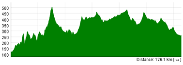
The fourth stage between Modbury and Tanunda is following a zig-zagging road from the start north-east of Adelaide.The top of the only referenced climb of the stage, at Kersbrook Road, will be reached after about 30 kilometers and the stage will offer the riders two opportunities to battle in an intermediate sprint, in Mount Pleasant and in Springton.

Saturday 26 January 2013 - 5/ McLaren Vale > Old Willunga Hill - 151.5 km
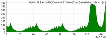
The 5th stage has now really become a classic for the Tour Down Under since it uses the now famous race route between McLaren Vale and Willunga. In order to allow this stage to finish on top of Old Willunga Hill and to give a climber a chance to win it, the stage has been made a bit longer last year (from 131 to 151.5 kilometers) by doing 3 times the longest loop between McLaren Vale, Willunga and Snapper Point (where they'll battle for a sprint twice) instead of 2 times and only one time (instead of 2 times as well) the shorter loop, with this time the finish on top of Old Willunga Hill. Due to the localisation of this climb, the riders will climb it twice anyway in this stage. This change has been kept for 2013 with the same stage route as last year.Herunder you'll find the race route of the fifth stage of the Tour Down Under 2013 on Google Maps and its profile. Click on the images to open them.

Sunday 27 January 2013 - 6/ Adelaide City Council Street Circuit - 90 km
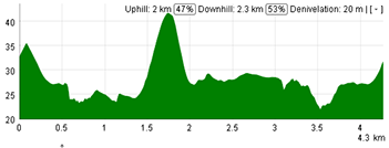
The sixth stage is quite a classic as well in the Tour Down Under, since it takes place every year on a circuit in the city center of Adelaide. This circuit is 4.5 km long and 20 laps will be on the programme to get to a total distance of 90 kilometers.At the 8th and 12th lap, the riders will sprint on the start/finish line, while in the 10th and 15th lap, they can win the final points for the King of the Mountain jersey on a very tiny climb which is called Montefiore Hill.
Herunder you'll find the race route of the sixth stage of the Tour Down Under 2013 on Google Maps and its profile. Click on the images to open them.

The Tour Down Under 2013 race route in Google Earth
If you prefer to see the race route of all the Tour Down Under 2013 stages in Google Earth, you can (if necessary after having installed Google Earth) click on the following link:> Download the Tour Down Under 2013 race route in Google Earth

Vond u dit artikel interessant? Laat het uw vrienden op Facebook weten door op de buttons hieronder te klikken!
2 comments | 5014 views
this publication is published in: Tour Down Under | Tour Down Under 2013 | OpenStreetMap/Google Maps/Google Earth


 by marco1988 over
am hoping that 2013 races will be clean so every rider will know their true potential,so if doping was the way ,that mine the races haven has a true winner,when you look at cyclist that has been ban for doping after two years coming back,i think that they should de ban for life .
The link for the Google Earth file is broken, it says 'Page non trouvée'. Can you fix it, please, if you still have the file? Thanks for the good work.