It was already completely announced on velowire.com since 20 January, but the Paris-Nice 2013 race route has now officially been announced today.
All stage cities announced here were correct and the only information we really discovered today was thus the distance of all stages and the profiles of the mountain stages. The other details still remain unknown for now, as usual.
The particularities of the race route that ASO insists on are the prologue which is not even 3 kilometers long, the straight line towards the finish of not less than 4 kilometers in Cérilly, the uphill finish on the Montagne de Lure on Friday and the individual time trial which is identical to last year's as the final stage climbing up from Nice to the top of the Col d'Eze.
The stages which form Paris-Nice 2013
As expected, a prologue and 7 stages together make up Paris-Nice 2013, the 71st edition of the race to the sun:CONTINUE READING AFTER THIS ADVERTISEMENT
P/ Sunday 3 March 2013 - Houilles - 2.9 km
As in previous years, the start of Paris-Nice 2013 will again take place in the department of the Yvelines, and that will be the case at least until 2017.It will all start with a prologue in the streets of Houilles which for once really correctly once will be called a "prologue". Indeed, it will only be 2.9 kilometers long and the first rider to wear the yellow jersey in this 71st edition of Paris-Nice will thus most probably be a specialist of the solo effort.
1/ Monday 4 March 2013 - Saint-Germain-en-Laye > Nemours - 195 km
The first stage will start close to Houilles, in Saint-Germain-en-Laye and the 195 kilometer long stage will most logically end in a sprint in Nemours.As far as we know for now, the riders will first go off in south-western direction, via Villepreux and Beynes and than go south via Le Perray-en-Yvelines and Rambouillet. The riders will go on in south-eastern direction via Dourdan, Etampes and Malesherbes before they climb the first hill of this 71th edition of Paris-Nice!
2/ Tuesday 5 March 2013 - Vimory > Cérilly - 200.5 km
The second stage, a little bit over 200 kilometers long, between Vimory and Cérilly will probably again end in a sprint and this time the sprinters teams will have to pay attention in the last few kilometers of the race since the last 4 kilometers will be a straight line, so the sprint can go off at any time.According to La République du Centre in October 2012, the start of the stage will take place in the Grande-Rue and the riders would than go towards the Allier department, over a flat race route for which the different cities being visited still remain to be defined, especially for the Loiret department.
In December, the same newspaper indicated that the riders will go on via Gien (usual start place of Paris-Bourges), and go via Saint-Brisson-sur-Loire (start place of a Paris-Nice stage in 2009), via Autry-le-Châtel and via Cernoy-en-Berry before they head to the finish in Cérilly (which we remember of the final time trial of the Tour de France 2008 [see the photos here] towards Saint-Amand-Montrond).
3/ Wednesday 6 March 2013 - Châtel-Guyon > Brioude - 171 km
In the 3rd stage, the riders will discover a more hilly race route for 171 kilometers between Châtel-Guyon and Brioude.CONTINUE READING AFTER THIS ADVERTISEMENT
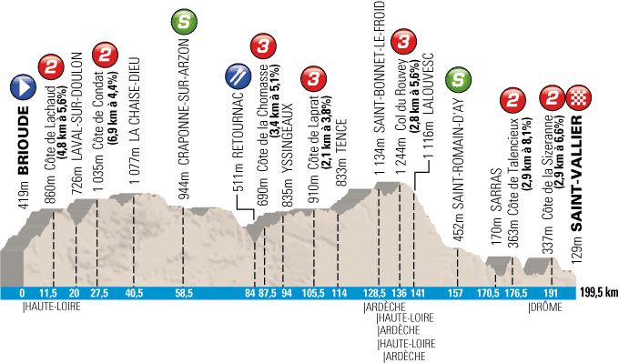
4/ Thursday 7 March 2013 - Brioude > Saint-Vallier - 199,5 km
The next day, the start of the 4th stage will also take place in Brioude for an even more hilly stage, of about 200 kilometers, towards Saint-Vallier.Hereunder you'll find the profile of this stage which will climb the following hills: the Côte de Lachaud (2nd category - 4.8 km @ 5.6%), the Côte de Condat (3rd category - 6.9 km @ 4.4%) at the start of the stage, followed halfway the stage by the Côte de la Chomasse (3rd category - 3.4 km @ 5.1%), the Côte de Laprat (3rd category - 2.1 km @ 3.8%) and the Col du Rouvey (3rd category - 2.8 km @ 5.6%) and two 2nd category in the final part of the stage: the Côte de Talencieux (2.9 km @ 8.1%) and the Côte de la Sizeranne (2.9 km @ 6.6%) of which the summit will be at less than 9 kilometers from the finish.

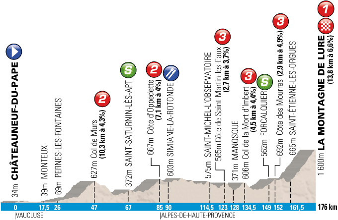
5/ Friday 8 March 2013 - Châteauneuf-du-Pape > la Montagne de Lure - 176 km
The 5th stage will be the first real mountain stage, which starts in Châteauneuf-du-Pape, and the mountaineous part mainly comes from the mountain top finish.Indeed, the first part of the stage is a bit hilly with the Col de Murs (2nd category - 10.3 km @ 4.3%), the Côte d'Oppedette (2nd category - 7.1 km @ 4%), the Côte de Saint-Martin-les-Eaux (3rd category - 2.7 km @ 3.7%), the Col de la Mort d'Imbert (3rd category - 4.5 km @ 4.4%) and the Côte des Mourres (3rd category - 2.9 km @ 4.9%) but the final climb will really influence the result of this stage, with the finish on top of the Montagne de Lure (1st category - 13.8 km @ 6.6%) where Alberto Contador took back the yellow jersey in Paris-Nice 2009.
Hereunder you'll find the profile of this stage:

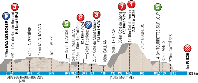
6/ Saturday 9 March 2013 - Manosque > Nice - 220 km
The rider who will wear the yellow jersey at the start of this stage will not be sure yet to take the overall win in Paris-Nice 2013 since the longest stage of this race which will bring the peloton to the usual finish on the Promenade des Anglais in Nice will, apart from the 2nd and 3rd category climbs (Côte du Bois de Rousset - 3rd category, 4.4 km @ 4.5%, Côte des Tuillières [also on the programme of the Tour Med this Sunday] - 2nd category, 2.2 km @ 7.8%, Côte du Mont Méaulx - 3rd category, 1.7 km @ 4.3%), two first category climbs which follow up on each other will probably make a shift in the peloton.The Côte de Cabris (7.6 km @ 5.8%) goes on in the Col du Ferrier (4.3 km @ 6.8%). However, when the riders reach the top of the last mentioned climb, there will still be 70 kilometers to go to the finish in Nice!
Hereunder you'll find the profile of this stage:

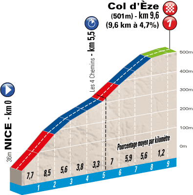
7/ Sunday 10 March 2013 - Nice > Col d'Eze - individual time trial - 9.6 km
Last year the time trial on the Col d'Eze already made its comeback in Paris-Nice and this year, the solo climb will again form the final stage of Paris-Nice 2013.The race route will be identical to last year's, so you can check out all the details at stage 8 in the article with the Paris-Nice 2012 race routes on Google Maps.
Hereunder you'll find the profile of this stage:

Of course you'll be able to find the race route on Google Maps/Google Earth for Paris-Nice 2013 a few days before the start of the race on velowire.com!
The map with the complet Paris-Nice 2013 race route
Hereunder you'll find the map with the complete race route of Paris-Nice 2013:
Vond u dit artikel interessant? Laat het uw vrienden op Facebook weten door op de buttons hieronder te klikken!
11 comments | 13109 views
this publication is published in: Paris-Nice | Paris-Nice 2013


 by marco1988 over
Bonjour,
Bravo Thomas, tu avais tout juste depuis un bon bout de temps..
Je suis consterné par ce parcours tellement faible qu'ASO a encore plus surcôté bon nombre de côtes pour le faire paraître plus dur.
Donc l'étape de Brioude que nous pensions vallonnée s'offrira à un sprinteur (ou aux échappés).
Saint-Vallier : un gros groupe (minimum 50 coureurs à l'arrivée).
Un samedi aussi râté que l'année dernière qui n'apportera rien.
Seules les étapes de la montagne de Lure et du col d'Eze auront une importance pour le général. Aucune arrivée après une courte côte, étape de montagne qui n'est qu'une course de côte, pas de kilomètres pour rouler avant Milan-San Remo : il ne faut pas s'étonner que de nombreux bons coureurs préfèrent Tirreno Adriatico qui en offre pour tous les goûts (et que la participation au tour de San Luis était plus alléchante que ce qui se profile pour Paris-Nice : peut-être qu'ASO veut faire gagner un Français).
Bonne journée
Suis d'accord avec ce 1ier commentaire : aucune étape vraiment préparatoire à une bonne prestation sur Milan-San Remo.
J'espère que l'avenir (proche désormais) me démentira)
P. C. 22
Une belle blague qu'est ce parcours. L'étape de Saint-Vallier n'a rien d'intéressant à part son final, l'étape de Nice ne donnera strictement rien (digne de Tarbes 2009 !), mais ma grosse déception est sans aucun doute l'étape de la Montagne de Lure.
POURQUOI UNE COURSE DE CÔTE ?!
Surtout que le tracé passe au pied (et je dis bien au pied !) de deux belles montées : le col de la Liguière (9,4 km à 6,4 %) et surtout le col de Lagarde d'Apt (11 km à 7 %) ! Mais ça va encore plus à l'est chercher une petite montée de rien du tout qui ne mérite même pas son statut de 2C. Faut dire que très peu de cols méritent leur classification dans le Paris-Nice !
Et puis de Simiane-la-Rotonde jusqu'à Saint-Etienne-des-Orgues, le parcours se permet un nouveau détour encore plus inutile rajoutant plus de plat, plus d'inactivité... Comme si le plateau d'Albion n'existait pas !
Une course d'attente au soleil en vue...
Sur l'étape du samedi, on reconnait bien la patte de Pescheux...
Superbe idée que de passer par les coins les plus reculés du Massif Central. A condition de l'exploiter correctement. Pescheux prends les coureurs pour des cyclotouristes du dimanche.
Lure, c'est mieux que Mende car plus long. Sur 3kms à 10%, tout le monde peut se mettre minable pour accrocher un résultat. Donc l'étape de Lure ne me dérange pas.
Les deux dernières étapes, c'est une vaste blague. Le copier-coller de l'an passé. Prudhomme a un contentieux avec le Var ou quoi? Qu'est ce que c'est que cette arrivée à Nice après 60 bornes de descente? Quand au chrono du col d'Eze, il est tellement court pour faire la différence que mettre un prologue reviendrait au même.
Le samedi, ils auraient pu stopper à Tourettes sur Loup, comme il y a 3 ans, arrivée difficile, en côte et proche du dernier col.
Le dimanche, si Prudhomme tient à son chrono individuel, il en fait un vrai, tout plat, Nice > Nice (pour que la promenade des anglais tienne son arrivée), pas trop long. Le même qu'au Tour (pourquoi pas?), 25 kms.
pour voir l'itinéraire de l'étape de Brioude, cliquer sur ce lien :
http://www.ville-houilles.fr/filemanager/download/2937
il y aura une boucle dans le final avec la Côte de Mauvagnat à 15,5 km de l'arrivée
Merci Julien
lamentable cette étape : col du Potey classé en 3C alors qu'il ne fait que 3.4 km à 5%. idem pour la côte de la forêt de Comté qui fait 3.9 km à 3.7%.
Quant à la côte de Mauvagnat, elle est classé 2C alors qu'elle ne fait que 3.75 km à 5.2%. Bref, 3 côtes qui ne servent à rien.
heureusement que Tirreno-Adriatico débute le même jour.
Bonne journée
Bonjour,
Après vérification, les itinéraires horaires de toutes les étapes sont disponibles sur cette page de la ville de Houilles. Chouette, je vais pouvoir me mettre à la préparation des cartes Google Maps (mais il y a le Tour du Haut Var d'abord !)
@julien, je me suis permis de modifier ton lien pour accéder plus facilement au fichier en question.
Je pense qu'on peut au passage saluer les efforts de communication de la ville de Houilles autour de cette course ! C'est rare de voir une ville aussi impliquée alors que les villes ont tout intérêt à le faire !
@Thomas Ils l'ont mis aussi sur le site officiel.
http://www.letour.fr/2013/PNC/COURSE/fr/100/etape_par_etape.html
Effectivement, mais l'avantage de la version officielle telle que publiée sur le site de la ville de Houilles est qu'il y a les détails des lieux de départs fictifs et réels et du trajet "balade" ainsi que le lieu exact de l'arrivée. Ce sont des informations dont j'ai besoin pour préparer les cartes et normalement je dois attendre la publication du livre de route en version électronique pour les avoir :-).
Je trouve ça assez énorme : c'est même pas ASO qui publie les itinéraires horaires !!!
Enfin, je vais pouvoir commencer à étudier la carte routière...