This weekend the Belgian classics will make their comeback in the UCI cycling calendar. The 2014 classics season starts as usual with the Omloop Het Nieuwsblad this Saturday and Kuurne-Bruxelles-Kuurne on Sunday.
Kuurne-Bruxelles-Kuurne didn't take place last year due to the snow and it'll thus only be this Sunday that we'll see who will follow up on Mark Cavendish who won the race in 2012. As for the Omloop Het Nieuwsblad (or Circuit Het Nieuwsblad if you prefer), Luca Paolini is the tenant of the title and the Italian rider of the Katusha team will be present this Saturday to defend his title.
In this article you'll find the itineraries, the profiles with the different bergs and the race route on Google Maps/Google Earth for these two Belgian classics.
CONTINUE READING AFTER THIS ADVERTISEMENT
Circuit Het Nieuwsblad 2014
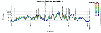
The weekend will thus start with the Circuit Het Nieuwsblad which will see the riders start in Ghent where they'll come back a few hours later and 198 kilometers further.After the fictive start from the Sint-Pietersplein, the riders will roll on behind the race organisor's car down to the church of Merelbeke 7.4 kilometers further. From there they'll go south to Ophasselt before going back north just above Zottegem. That's where the area with the different bergs of this race starts.
Going west until Horebeke, they'll then go south to Brakel where they'll find the first berg of this circuit, the Leberg [950 m - 4.2% (max 13.8%)]. Back in Zottegem they'll climb the Hostellerie [1375 m - 5.1% (max 9%)] before they go to the most southern part of this race, in Geraardsbergen, where they'll climb the well-known Wall of Geraardsbergen with its famous chapel.
The riders will then go back north to Brakel where they'll climb the Valkenberg [540 m - 8.1% (max 12.8%)] but also to get some revitalising food. They'll then go to the most western point of the race, in Ronse, where they'll find the climb of the Kruisberg [1800 m - 4.8% (max 9%) - of which 450 m are cobbles].
Going back north towards Oudenaarde they'll climb 3 other bergs: the Taaienberg [530 m - 6.6% (max 15.8%) - of which 500 m are cobbles], the Eikenberg [1200 m - 5.2% (max 10%) - completely made of cobbles] and the Wolvenberg [645 m - 7.9% (max 17.3%)].
From there they'll go back south to Brakel where they'll climb the Leberg for the second time [again 950 m - 4.2% (max 13.8%)], then continuing a bit back north and start the trip eastwards via the Molenberg in Zwalm [463 m - 7% (max 14.2%) - of which 300 m are cobbles]. From there, they'll go back north towards Ghent where the finish will also take place on the Sint-Pietersplein.
Hereunder you'll find the itinerary, the profile and the race route on Google Maps of the Circuit Het Nieuwsblad 2014. Click on each of the images to open them.


>> Download the Circuit Het Nieuwsblad 2014 race route in Google Earth
>> Check the list of participating riders in the Circuit Het Nieuwsblad 2014
Kuurne-Bruxelles-Kuurne 2014
As for Kuurne-Bruxelles-Kuurne 2014, the race will take place on Sunday 2 March 2014, with several circuits in the west-east zone between Kuurne and Ninove. A part of this race route visits the same area as the Circuit Het Nieuwsblad the day before and some of the bergs are thus common to these two races.After the fictive start from the Hippodrome of Kuurne, the riders will really start the race in the Bavikhoofsestraat where it crosses the Tweegemeentenweg. From there, they'll go south down to Harelbeke where they'll turn east and head towards Oudenaarde and then to Edelare where they'll find the first berg of the day, the Edelareberg [1500 m - 4.2% (max 7%)].
Once they get to the most eastern point of the race, in Voorde, the riders go south to Zandberge where they'll start the journey back west. Via Geraardsbergen they'll arrive in the feeding zone in Zarlardinge, after 81 kilometers in the race and with still 116 kilometers to go. Continuing in this direction, they'll climb 3 others of the total of 9 bergs of this race, La Houppe [1880 m - 4.8% (max 10%)], the Kanarieberg [1000 m - 7.7% (14%)] and the Kruisberg [1875 m - 4% (max 9%)].
Once they get in Russeignies, they'll go back north via the Côte de Trieu [260 m - 7% (max 13%)] before they do a short circuit to the east, in order to reach the Old Quaremont (Oude Kwaremont) [2200 m - 4% (max 11.6%)] from the north. Going back up north they'll get close to the race route they used on their way east at the start of the race, but this time they go west towards Tiegem where they'll climb the Tiegemberg [750 m - 5.6% (max 9%)]. In Anzegem they briefly follow a part of the race route they used initially but then turn left to climb the Holstraat [1000 m - 5.2% (max 12%)].
Continuing north until Nokere, they'll get on the Nokereberg [350 m - 5.7% (max 7%)], the last berg of the day. From there they'll get back, via Waregem and Desselgem, to Kuurne, where they'll do two laps on a local circuit of 16 kilometers down to Kortrijk.
Hereunder you'll find the itinerary, the profile and the race route on Google Maps of Kuurne-Bruxelles-Kuurne 2014. Click on each of the images to open them.


>> Download the Kuurne-Bruxelles-Kuurne 2014 race route in Google Earth
>> Check the list of participating riders in Kuurne-Bruxelles-Kuurne 2014 door Thomas Vergouwen
Vond u dit artikel interessant? Laat het uw vrienden op Facebook weten door op de buttons hieronder te klikken!
no comments yet | 5974 views
this publication is published in: Classics


 by marco1988 over