This Wednesday, the first French stage race of the 2015 season, the Etoile de Bessèges, will start in Bellegarde and it will finish in Alès on Sunday.
3 of the 5 stages of this 45th edition of the Etoile de Bessèges are identical to the Etoile's race route in 2013 but since last year, the race only has 5 stages, of which one is an individual time trial, on the last day. In this article you'll find the race route on Google Maps/Google Earth and even for the identical stages, the race route has been re-drawn more precisely and presented in a better way (with color codes).
The race will take place from Wednesday 4 till Sunday 8 February 2015. Often dominated by the sprinters in the different stages in line, the race's classification could be largely influenced by the uphill time trial as the final stage. 622 kilometers await the riders in these 5 stages.
CONTINUE READING AFTER THIS ADVERTISEMENT
1/ Wednesday 4 February 2015 - Bellegarde > Beaucaire - 154 km
After the start of this first stage in Bellegarde, the riders will go off south-east down to Fourques (the double line bit on the map is not a mistake: in order to leave the D6113 and enter Fourques, the riders will go a bit too far and then turn around on the roundabout) before they go up north to Beaucaire and back to Bellegarde (this part of the race route is in purple).In the start city, they'll take the Rue de la Tour in order to climb the Côte de la Tour, a 2nd category climb (which will be the start of the orange part of the race route). After this first climb of the Etoile de Bessèges 2015 they'll continue north-east via Saint-Vincent, Montfrin and Aramon and then cross the Rhône and go back down, following the Rhône, via Vallabrègues where they'll cross the Rhône again.
They'll cross the Île du Comté and get back to Bellegarde where a new climb of the Côte de la Tour awaits. Via Fourques they'll go back to Beaucaire where they'll do an intermediate sprint on the finish line in the Quai de la Paix (the yellow part of the race route).
Finally, they'll do 4 laps on a 6.6 km long circuit around Beaucaire (the blue part of the race route).
Hereunder you'll find the time- and route schedule, the race route on Google Maps for this stage and its profile.


2/ Thursday 5 February 2015 - Nîmes > Les Fumades - 157 km
The start and finish cities of this 2nd stage are the same as for the stage in 2013 and the distance which separates these two cities as wel. The race route is however slightly different: the stage will start in Nîmes and the riders will go off north, up to Uzès where they'll turn north-west almost up to Saint-Hippolyte-de-Caton. They'll turn north again there, via Brouzet-lès-Alès and towards Les Fumades. When they first cross the finish line they'll do an intermediate sprint and then continue north of the finish, via Potelières, Saint-Ambroix, Saint-Denis, Barjac and Saint-Privat-de-Champclos where they'll already have started to get back down to the finish line, via Montclus, Méjannes-le-Clap and Rochegude.They'll again approach the finish line in Les Fumades but they'll still have to do 3 laps of 7.7 kilometers around the finish city.
Hereunder you'll find the time- and route schedule, the race route on Google Maps for this stage and its profile.


3/ Friday 6 February 2015 - Bessèges > Bessèges - 152 km
The 3rd stage follows the same race route as usual and will start and finish in Bessèges, the city which gave its name to the race and where it usually finished until 2011.After the start, the riders will go off eastwards until Le Vieux Buis before they get to the hilly area around Bessèges where they'll climb the Col de Trélis.
After this climb, they'll continue south-east until Saint-Florent-sur-Auzonnet and then north-east via Molières-sur-Cèze and Saint-Brès where they'll turn north-west until they get close to Sauvas where they go up north back to Bessèges.
When they first cross the finish line they'll do the first intermediate sprint, followed by the same 44.4 kilometers long circuit 2 times again, with another intermediate sprint at the 3rd crossing of the line.
As the final part of the stage, the organisor of the race has set up 3 laps on a 6.8 kilometers long circuit around Bessèges.
Hereunder you'll find the time- and route schedule, the race route on Google Maps for this stage and its profile.


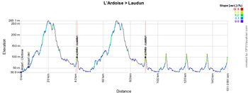
4/ Saturday 7 February 2015 - L'Ardoise > Laudun - 147 km
The 4th stage will start in L'Ardoise and after the kilometer 0, the riders will go towards Saint-Laurent-des-Arbres and Tavel before they continue west towards Pouzilhac. Before they get there, they'll turn north via Saint-Victor-la-Coste, Saint-Paul-les-Fonts and Connaux and on to the first crossing of the finish line which will be drawn in the Impasse Edouard Branly close to the Arènes of Laudun-l'Ardoise.The sprint on the finish line brings an end to the first circuit, drawn in orange on the map. After a visit up north via Orsan and back down to L'Ardoise and another road than in the previous circuit towards Saint-Laurent-des-Arbres they'll get back on the first circuit which they'll follow until the finish line (yellow circuit).
The riders will still have to do 4 laps on a 15.4 kilometers long final circuit, drawn in bleu on the map, which pretty much follows the roads of the second circuit, for the part north of the finish city, via Orsan.
Hereunder you'll find the time- and route schedule, the race route on Google Maps for this stage and its profile.


CONTINUE READING AFTER THIS ADVERTISEMENT
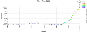
5/ Sunday 8 February 2015 - Alès > Alès - individual time trial - 12 km
The last stage of the Etoile de Bessèges will be an individual time trial which will be uphill and start in Alès. Leaving the Place Henri Barbusse (close to the Cratère, the theatre of Alès), each rider will first go up to N106 and then back down the other way around, before they turn right on the Pont Vieux bridge. They briefly follow the quai on the other side of the Gardon d'Alès river and then turn on the Route de Saint-Jean-du-Pin from where they'll turn right on the Promenade de l'Ermitage which they'll climb up to the top.This stage will most probably (as usually) have a big influence on the overall general classification of the race. Indeed, if a good climber pays attention to finish in the same time as the winner on the sprint stages, he could be well placed to win the Etoile de Bessèges 2015 by taking some time in this final stage, like Tobias Ludvigsson (Giant-Shimano) did last year by winning this final stage and thus the general classification of the race.
Hereunder you'll find the time- and route schedule, the race route on Google Maps for this stage and its profile.


L'Etoile de Bessèges 2015 in Google Earth
If you prefer to see the complete Etoile de Bessèges 2015 race route in Google Earth, for example to do a virtual fly-over of the different stages, you can download it in Google Earth by clicking on the following link:> Download the Etoile de Bessèges 2015 race route in Google Earth

Vond u dit artikel interessant? Laat het uw vrienden op Facebook weten door op de buttons hieronder te klikken!
1 comment | 9036 views
this publication is published in: Etoile de Bessèges | OpenStreetMap/Google Maps/Google Earth


 by marco1988 over
Vu la partie finale de la dernière étape - qui, de plus, est contre la montre -, je ne serais pas étonné s'il y avait des bouleversements au profit de "grimpeurs explosifs".