Saturday 25 March 2017 at 15h35
After "A Travers les Flandres" (won by Yves Lampaert) and the E3 Harelbeke (won yesterday by Greg van Avermaet), the Belgian classics continue this Sunday with Ghent-Wevelgem, a 249.2 kilometer long race (6.4 more than last year) which will come through a hilly area which often decides the outcome of the race in the second part of it.
In this article you'll find the race route on Google Maps/Google Earth for Ghent-Wevelgem 2017 and that race route is slightly different from last year!
CONTINUE READING AFTER THIS ADVERTISEMENT
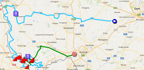
The Ghent-Wevelgem 2017 race route on Google Maps
On Sunday morning, the riders and followers of the classics will meet up in .. Deinze for the start of Ghent-Wevelgem. Indeed, like many other races this race also carries the name of its historical start location but since 2004 already, the race doesn't start from Ghent anymore.The race route of this race has been slightly modified compared to 2016 and even the climbs are not exactly the same. Enough changes to force me to completelty redraw the map!
From Deinze the riders will leave westwards via Tielt, Kortemark and Diksmuide and Veurne and it's first feeding zone and that's where we'll see the first big change (there are also some minor changes in the previous part). Instead of crossing the border with France in Oostkappel towards Wormhout, the riders will follow the Belgian/French border on the Belgian side down to Abele where they'll go on to Godewaarsvelde on the other side of the border and where they'll get back on the usual race route. They'll go on with the climb of the Catsberg, which will thus again be the first climb this year. They'll continue with the climbs of the Kokereelberg, Vert Mont and the Zwarte Berg which will be climbed from two sides: Côte du Ravel Put first, followed by Côte de la Blanchisserie.
Before they get back in Belgium, there will again be another change, which allows to add another climb, the Ravensberg and they'll get back on the usual route when they turn left towards the climb of the Baneberg, the 7th climb of the day (6th climb last year). Close to Heuvelland they'll find two other climbs, the Kemmelberg (Belvedère) and the Monteberg.
They'll loop back (going on in the green part of the race route on the map) towards the 7th climb which thus also becomes the 10th, the Baneberg, again followed by the climb of the Kemmelberg, from the other side (Ossuaire).
Back in Heuvelland the riders will this time turn left towards Ieper from where they'll follow the main roads towards the finish in Wevelgem. This final part is identical to the one in 2015 and 2016.
Who will follow up on Peter Sagan (Tinkoff at that time, now Bora-Hansgrohe) tomorrow as the winner of this classic? Will the extra climb (Ravensberg) change anything?
Hereunder you'll find the time- and route schedule, the race profile and the race route on Google Maps for Ghent-Wevelgem 2017. Click on the images to open them.


The Ghent-Wevelgem 2017 race route in Google Earth
If you prefer to see the Ghent-Wevelgem 2017 race route in Google Earth, for example to do a virtual fly-over of it, you can! In order to do so, download the KML file below and open it in Google Earth:>> Download the Ghent-Wevelgem 2017 race route in Google Earth

Vond u dit artikel interessant? Laat het uw vrienden op Facebook weten door op de buttons hieronder te klikken!
no comments yet | 16419 views
this publication is published in:


 by marco1988 over