In one week, the Tour Down Under will start in South-Australia, in Prospect to be more precise. 803 kilometers further, in Adelaide, we'll know who will be the winner of the first race of the UCI WorldTour 2012.
This will all, as usual, be preceded by the Down Under Classic, which is not officially part of the Tour Down Under but which is part of the official UCI criterium calendar which thus allows the riders of the UCI ProTeams to participate.
In this article you'll find all information about the race route of the Tour Down Under 2012 including most importantly Google Maps/Google Earth maps of it.
The Tour Down Under 2012 will take place from Tuesday 17 till Sunday 22 January 2012 and is since several years now the first race of the UCI WorldTour, thus preceding Paris-Nice which will as usual take place in March.
TV broadcasting in collaboration with ASO
Following the AMGEN Tour of California, which signed an agreement with Amaury Sport Organisation (ASO) for the mutual promotion of this race and the Tour de France and the international distribution of broadcasting rights in 2008 (the agreement became active since the 2009 edition of the American race), the Santos Tour Down Under will collaborate from 2012 with the French organisor of sports events as well for the TV broadcasting of the race worldwide.That's the reason why Christian Prudhomme, director of cycling with A.S.O., and Julien Goupil, director medias at A.S.O., will for the first time be present at the opening race of the UCI WorldTour. They will assist to 3 days of the race, starting on Tuesday 17 January, that is for the first 3 stages.
The Tour Down Under race route on Google Maps
Let's check out the different stages one by one ...CONTINUE READING AFTER THIS ADVERTISEMENT
Sunday 15 January 2012 - Down Under Classic - 51 km
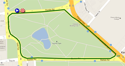
Everything will start with the Down Under Classic which is thus not officially part of the Tour Down Under as a UCI WorldTour event.As usual, a closed circuit of 1.7 kilometers around Rymill Park will form the completely flat race route for this Down Under Classic. The riders will do 30 laps on this circuit which means they'll get to a total distance of 51 kilometers. The start of the race will be at 7PM for an expected finish around 8PM. It will preceded at 4.45PM by the team presentation of the Tour Down Under 2012.
At the 5th, 10th, 15th and 20th crossing of the finish line, the riders can take additional primes in a sprint.
Hereunder you'll find the race route of the Down Under Classic on Google Maps and its profile. Click on the images to open them.


Tuesday 17 January 2012 - 1/ Prospect > Clare - 149 km
On Tuesday the race will really start with the official start of the Tour Down Under which will be watched at by Mike Turtur, the director of the race, but also by Christian Prudhomme.The start of this first stage will be at less than 5 kilometers north of the nerve centre of the race (Adelaide), in Prospect. After a start going north, the race route goes nort-east up to Kapunda where the riders will battle in the first sprint of this 14th edition of the Tour Down Under and where they'll also find the feeding zone mid-race.
En tournant légèrement vers le nord-ouest et en prenant les premiers points pour le classement de meilleur grimpeur entre Kapunda et Tarlee, les coureurs trouveront le deuxième sprint à Riverton et il ne leur reste alors plus que 45 kilomètres à faire jusqu'à l'arrivée à Clare au bout de 149 kilomètres de course.
Ci-dessous vous trouverez la carte Google Maps de la première étape du Tour Down Under 2012 et son profil. Cliquez sur les images pour les agrandir.


Wednesday 18 January 2012 - 2/ Lobethal > Stirling - 148 km
The second stage has a similar length to the first one, but a little bit more hillyu profile. After the start from Lobethal the riders will first go north towards Gumeracha and Birdwood before going back, via a sprint in Mount Torrens, to Lobethal. From there, the riders will first go north-west before turning around down to Woodside and than towards Mylor where they'll again get on a circuit which they'll do 3 times while passing through the finish in Stirling where they'll not only see the finish line but also where they'll be able to feed themselves at the first crossing of that finish line.Herunder you'll find the race route of the second stage of the Tour Down Under 2012 on Google Maps and its profile. Click on the images to open them.


Wednesday 19 January 2012 - 3/ Unley > Victor Harbor - 134.5 km
The 3rd stage of the Tour Down Under 2012 will take place south of Adelaide. The start will be in Unley, at about 3 kilometers from the central point of the race and the real start will be in Bedford Park and from there the riders will follow the coast southwards to get to the only difficulty of this stage, Sellicks Hill, after about 43 kilometers in the race. From there, the riders will get on a zig-zaggy race route via Myponga to the sprint in Mount Compass. The feeding zone will be at about 5 kilometers after this sprint before the whole race crew continues towards the sprint in Goolwa. The last part of this 3rd stage starts there, following the coast up to Hayborough where they'll go back landinwards to end this stage, on the coast, in Victor Harbor after 134.5 kilometers of racing.Hereunder you'll find the race route of the third stage of the Tour Down Under 2012 on Google Maps and its profile. Click on the images to open them.


CONTINUE READING AFTER THIS ADVERTISEMENT
Friday 20 January 2012 - 4/ Norwood > Tanunda - 130 km
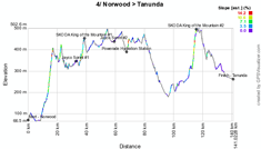
This 4th stage will take place on the north-east side of Adelaide and after the fictive start from Norwood, the real start will be at some kilometers from there in a place which answers to the beautiful name of Paradise. Going east, the riders will battle for the first sprint in Kersbrook, climb Smith Hill in Forreston and will battle for a new sprint in Mount Pleasant. From there, they'll go north towards Springton where they'll find the feeding zone before turning west up to Williamstown where they'll again go north down to Bethany. Before they get in Tanunda after 130 kilometers, they'll go find some additional kilometers with a short loop which allows to climb Mengers Hill and get some additional points for the KOM jersey.Herunder you'll find the race route of the fourth stage of the Tour Down Under 2012 on Google Maps and its profil. Click on the images to open them.


Saturday 21 January 2012 - 5/ McLaren Vale > Old Willunga Hill - 151.5 km
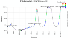
The 5th stage is a big classic for the Tour Down Under since it uses the now famous race route between McLaren Vale and Willunga. However, in order to allow this stage to finish on top of Old Willunga Hill and to give a climber a chance to win it, the stage has been made a bit longer (from 131 to 151.5 kilometers) by doing 3 times the longest loop between McLaren Vale, Willunga and Snapper Point (where they'll battle for a sprint twice) instead of 2 times and only one time (instead of 2 times as well) the shortes loop, with this time the finish on top of Old Willunga Hill. Due to the localisation of this climb, the riders will climb it twice anyway in this stage.Herunder you'll find the race route of the fifth stage of the Tour Down Under 2012 on Google Maps and its profile. Click on the images to open them.


Sunday 22 January 2012 - 6/ Adelaide City Council Street Circuit - 90 km
As usual, the last stage takes place every year on a circuit in the city center of Adelaide. This circuit is 4.5 km long and 20 laps will be on the programme to get to a total distance of 90 kilometers.At the 8th and 12th lap, the riders will sprint on the start line, while in the 10th and 15th lap, they can win the final points for the King of the Mountain jersey on a very tiny climb which is called Montefiore Hill.
Herunder you'll find the race route of the sixth stage of the Tour Down Under 2012 on Google Maps and its profile. Click on the images to open them.


The Tour Down Under 2012 race route in Google Earth
If you prefer to see the race route of all the Tour Down Under 2012 stages in Google Earth, you can (if necessary after having installed Google Earth) click on the following link:> Download the Tour Down Under 2012 race route in Google Earth

Vond u dit artikel interessant? Laat het uw vrienden op Facebook weten door op de buttons hieronder te klikken!
no comments yet | 6396 views
this publication is published in: Tour Down Under | Tour Down Under 2012


 by marco1988 over