Sunday 26 February 2012 at 00h47
A little bit over one week ago, on Friday 14 February, ASO published the route- and timetables of Paris-Nice 2012, the 70th edition of the Race to the sun.
Without any surprises when it was officially announced on the 2nd of February (at the end of December, velowire.com already presented you this race route), this edition will start in the Yvelines department, for 8 stages of which 2 (the first and the last) will be individual time trials.
In this article you'll find all details about the race routes, including Google Maps/Google Earth versions of each of the stages, the route- and timetables and the stage profiles.
The Paris-Nice 2012 race route on Google Maps
This 70th edition of Paris-Nice will have a total of 1,155.5 kilometers spread out over 8 stages. The two time trial stages have a similar distance, 9.4 (for the first one) and 9.6 (for the last one) kilometers. The shortest stage will be on Wednesday 7 March, from Brive-la-Gaillarde to Rodez, the 4th stage with a distance of 178 km. The longest stage is the forelast one, between Sisteron and Nice, over 219.5 km.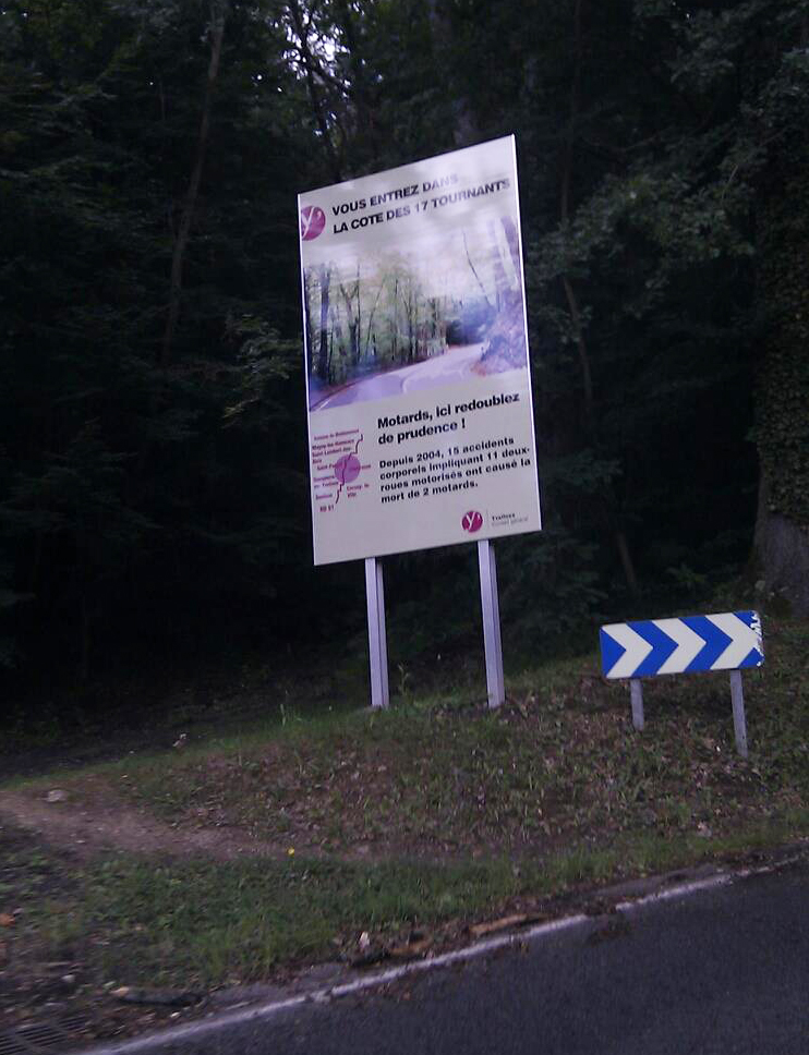 This edition will contain a total of 13 3rd category difficulties (including the Côte des 17 tournants in the first stage), 6 of the 2nd category and 5 of the first category, including the mountain top finishes in Mende (the Montée Laurent Jalabert) and on top of the Col d'Eze.
CONTINUE READING AFTER THIS ADVERTISEMENT
1/ Sunday 4 March 2011 - Dampierre-en-Yvelines > Saint-Rémy-lès-Chevreuse - ITT - 9.4 km
The first stage of Paris-Nice 2012 will be an individual time trial between Dampierre-en-Yvelines and Saint-Rémy-lès-Chevreuse in the Vallée de Chevreuse, favourite terrain for amateur cyclists in the Parisain area.Right from the start, this stage will let the riders climb the Côte des 17 Tournants. Only a bit over one kilometer long, it makes the time trial a little bit particular compared to the usual flat roads.
The start ramp in Dampierre will be set up in front of the castle while the finish will be in front of the RER railway station in Saint-Rémy. And to give you an idea of where exactly that start will be, you can have a look at the panorama picture I created last Sunday (use the scrollbar below the image to see the whole panorama):
Hereunder you'll find the route and timetable, the stage profile and the race route on Google Maps for this stage. Click on each of the images to open them.


2/ Monday 5 March 2012 - Mantes-la-Jolie > Orléans - 185.5 km
The second stage will start a bit more north-west of Paris, in Mantes-la-Jolie. After the start on the Pont de Limay, the riders will go south until they arrive in Houdan where they'll turn towards Rambouillet and to the only climb of this stage, the Côte des Granges-le-Roi (3rd category).Just aftet this climb, they can get some new energy in the feeding zone close to Authon-la-Plaine. They'll continue their descent southwards and will get to the intermediate sprint of the stage in Neuville-aux-Bois.
They'll finally get to the finish in Orléans turning around the city on the sides of the Loire river on the east and south side. The finish line will be drawn in the Boulevard Alexandre Martin at the end of a final straight line of 250 meters.
Hereunder you'll find the route and timetable, the stage profile and the race route on Google Maps for this stage. Click on each of the images to open them.


3/ Tuesday 6 March 2012 - Vierzon > Le Lac de Vassivière - 194 km
The 3rd stage of the first race of the UCI WorldTour 2012 calender in Europe will have quite an original start. Indeed, after the fictive start from the Place du Cirque National Amédée / Rue du Général de Gaulle in Vierzon, the riders will do a short loiop in the streets of this city. After this loop, they will turn left towards the D518 where the real start will be.After the start, they will get, via Issoudun, to the feeding zone in Aigurande and via Dun-le-Palestel, known for its criterium, they'll go south towards Bourganeuf and the 3rd category climb with the same name. Via Peyrat-le-Château where they will do the intermediate sprint, they'll start the climb towards the Lac de Vassivière in Auphelle where the finish will give a nice viewpoint on the lake, at the starting point of the Circuit Raymond Poulidor.
Hereunder you'll find the route and timetable, the stage profile and the race route on Google Maps for this stage. Click on each of the images to open them.


4/ Wednesday 7 March 2012 - Brive-la-Gaillarde > Rodez - 178 km
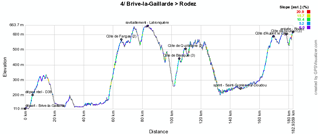
A little bit south of Lac de Vassivière, the teams will come to the start of the 4th stage on the Place du 14 Juillet in Brive-la-Gaillarde the next day.60 kilometers further, the riders will have to climb the Côte de Fangas (2nd category), before they get to the feeding zone in Latronquière. They'll than continue with the 3rd category climb of the Côte de Blanquie and the 2nd category Côte de Quotidiane before the descent towards to the sprint in Saint-Cyprien-sur-Doudou.
Before they get to the finish, they still have to climb two 3rd category climbs: the Côte d'Aubert le Crès and, via Onet-le-Château, finally the Côte de Bourran.
The finish line will be drawn in the Avenue Victor Hugo, at the end of a 300 meter straight line.
Hereunder you'll find the route and timetable, the stage profile and the race route on Google Maps for this stage. Click on each of the images to open them.


CONTINUE READING AFTER THIS ADVERTISEMENT
5/ Thursday 8 March 2012 - Onet-le-Château > Mende - 178.5 km
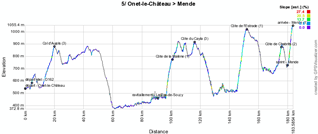
In the outskirts of Rodez, the start of the 5th stage will be in the Boulevard des Capucines in Onet-la-Château. After a zig-zag part in the city, the riders will go towards the climb of the Col d'Aujols.Via Ségur and Aguessac and than going back up via Les Vignes, the peloton gets to Le Pas-de-Soucy where the feeding zone will be and they'll than continue with the climb of the Côte de la Malène (1st category), the Côte du Cayla (3rd category), the Côte de l'Estrade (1st category) and finally the Côte de Chabrits (2nd category).
Close to the finish, in Mende, the riders will battle for the intermediate sprint, before they start the final climb towards La Croix Neuve and its famous Montée Laurent Jalabert.
Hereunder you'll find the route and timetable, the stage profile and the race route on Google Maps for this stage. Click on each of the images to open them.


6/ Friday 9 March 2012 - Suze-la-Rousse > Sisteron - 178.5 km
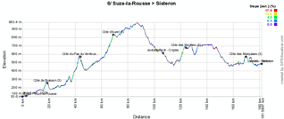
After an important transfer towards Suze-la-Rousse, the peloton will start this stage on the Parking des caves de la Suzienne for a stage with exactly the same distance as the previous one.The first difficulty of the day will be the Côte de Buisson (3rd category) and after having visited Vaison-la-Romaine, the best climbers will show their capacities on the flanks of the Côte du Pas du Ventoux (2nd category). Turning around its big brother, the Mont Ventoux, they will finally end up on the climb of the Côte d'Aurel (3rd category).
Via Revest-du-Bion and Banon, they'll get to the feeding zone in Ongles and after a short visit of Forcalquier, the riders will start the climb of the Côte des Mourres (3rd category). They'll than continue their journey to the north up to Saint-Etienne-les-Orgues before turning east and north-east towards the finish line in Sisteron. At the first crossing of the finish line, the intermediate sprint is on the programme, before the riders get on a local circuit of 19 kilometers around the finish city, which for example allows to get to the climb of the Côte des Marquises (3rd category). The finish line will be drawn on the Avenue de la Libération, in front of the train station, at the end of a 3 km long straight line of which 700 meters with a continuous view.
Hereunder you'll find the route and timetable, the stage profile and the race route on Google Maps for this stage. Click on each of the images to open them.


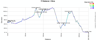
7/ Saturday 10 March 2012 - Sisteron > Nice - 219.5 km
The next day the start will be at only a few meters from there, in the Avenue des Arcades / Pré de Foire, still in Sisteron. Via the finish line of the previous stage, the peloton leaves the Porte de la Provence via the citadelle with view on the typical rocher de la Baume, going towards the real start of this forelast stage, which will be at 7.5 km from the place where they gathered together.From there, the stage route will go north-east to get to the chain of Col des Lèques (2nd category), the feeding zone in La Garde, the Col de Luens (2nd category) and the Côte de Peyroules (3rd category). After a part of the stage route going east, a new descent to the south will bring the riders to the intermediate sprint in Tourrettes-sur-Loup followed by a part going back north to find the Col de Vence (1st category / 9.7 km at 9.6%).
Via Coursegoules and Carros, the riders will get back down to the sea side at Saint-Laurent-du-Var where they'll continue towards the usual finish on the Promenade des Anglais in Nice. Well, usual ... yes and no. Indeed, this time it will not be for the last stage but for the forelast stage.
Hereunder you'll find the route and timetable, the stage profile and the race route on Google Maps for this stage. Click on each of the images to open them.


8/ Sunday 11 March 2012 - Nice > Col d'Eze - 9.6 km - ITT
Indeed, the last stage will bring back the historical time trial between Nice and the Col d'Eze. With a distance of no more than 9.6 kilometers, this time trial can however be decisive for the general classification of this Paris-Nice 2012 because only the riders who are able to combine the qualities necessary for the solo effort and the climbing will have a chance to get a good result and thus defend their position in this classification or even to get to the podium at the end of this stage. At 11.40AM, the first rider will start his climb of the Col d'Eze while the last one is expected to arrive on top around quarter to three!An intermediate timing point will be installed on the Col des Quatre Chemins.
Hereunder you'll find the route and timetable, the stage profile and the race route on Google Maps for this stage. Click on each of the images to open them.



The Paris-Nice 2012 race route in Google Earth
You have just discovered all details of the stage route of the 70th edition of Paris-Nice, including the route- and timetables, the stage profiles and the maps with the race routes in Google Maps for each of the stages. If you'd like to have a look at the whole Paris-Nice 2012 race route, you can download the following KML file and open it in Google Earth:>> Download the Paris-Nice 2012 race route in Google Earth (KML file)

This file will also allow you to do a virtual fly-over of one or more of the stages of Paris-Nice 2012.
By clicking on the icons shown on the different Google Maps in this article or in Google Earth you get access to more information about the places where the stages will start and finish, the sprints, the feeding zones and the climbs. door Thomas Vergouwen
Vond u dit artikel interessant? Laat het uw vrienden op Facebook weten door op de buttons hieronder te klikken!
2 comments | 36073 views
this publication is published in: Paris-Nice | Paris-Nice 2012 | OpenStreetMap/Google Maps/Google Earth


 by marco1988 over
http://www.les-actus-du-cyclisme.fr/article-le-parcours-de-paris-nice-2012-sur-google-maps-google-earth-et-les-itineraires-horaires-profils-d-100219407.html
Riders Geolocator.
Paris > Nice 2012 on http://blognoster.com/parigi_nizza/