This Saturday the 3rd Grand Tour of the year, the Tour of Spain 2014, will start in Jerez de la Frontera with a nightly team time trial of 12.6 kilometers.
3,239.9 kilometers and 21 stages later, the Vuelta a España 2014 will end with an individual time trial around Santiago de Compostela.
In this article you'll find the race routes of this 69th edition of the Tour of Spain which will take place from 23 August till 14 September 2014 on Google Maps. Finally, you can open these maps in Google Earth in order to see a big version of them or to do a virtual fly-over of one or more of the stages!
If you'd like to know some background information and statistics of this Vuelta a España 2014, you can read the article The Tour of Spain 2014: the riders on the road to Santiago de Compostela.
Due to a lack of time, the contents of this article are entirely based on the maps and profiles provided by the official web site of the race.
The Vuelta a España 2014 race route on Google Maps
CONTINUE READING AFTER THIS ADVERTISEMENT
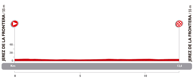
1/ Saturday 23 August 2014 - Jerez de la Frontera > Jerez de la Frontera - team time trial - 12.6 km
The first stage of the Tour of Spain 2014 is a team time trial, over a distance of 12.6 kilometers, in Jerez de la Frontera. This race against the clock takes place on a completely flat race route which is however quite technical in this start city of the Vuelta a España 2014. The start ramp will be in a park in the center of Jerez de la Frontera and on a part of the race route, the riders will see their competitors on the other side of the road because they make a U-turn on two roundabouts at the north side of the city.Hereunder you'll find the stage itinerary, the profile and the race route on Google Maps for this stage. Click on the images to open them.


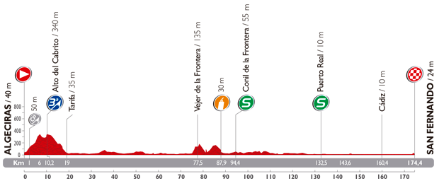
2/ Sunday 24 August 2014 - Algeciras > San Fernando - 174,4 km
The first stage in line of this Tour of Spain 2014 will take place between Algeciras and San Fernando over a distance of about 175 kilometers. In order to get to the start, the riders and the followers of the race will have done quite a big transfer after the time trial the day before in order to get to the start city on the sea side. This will be a flat stage with only one 3rd category climb early in the stage (its summit will be reached after 10.2 kilometers), the Alto del Cabrito. The stage follows the coast line but if the sprinters don't get surprised by the sea wind which could have them end up in the wrong group, this stage will be made for them.Hereunder you'll find the stage itinerary, the profile and the race route on Google Maps for this stage. Click on the images to open them.


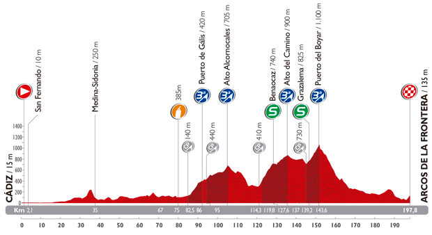
3/ Monday 25 August 2014 - Cádiz > Arcos de la Frontera - 197.8 km
The 3rd stage ends the visit of the province of Cádiz, with a stage between its capital city, Cádiz, and Arcos de la Frontera, north-east of the capital.Almost 200 kilometers will seperate the start from the finish and 4 climbs of the 3rd category will brighten up this stage (Puerto de Gális, Alto Alcomocales, Alto del Camino and Puerto del Boyar) and even though the last part of the stage is pretty much downhill, it's interesting to note that the last two kilometers are rather uphill and will probably lead to a selection before the finish!
Hereunder you'll find the stage itinerary, the profile and the race route on Google Maps for this stage. Click on the images to open them.


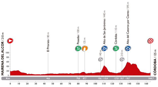
4/ Tuesday 26 August 2014 - Mairena del Alcor > Córdoba - 164,7 km
This 4th stage is a flat stage, starting with 105 kilometers flat. Indeed, after the start in Mairena del Alcor the race route will be flat untill the foot of the Alto de San Jerónimo (3rd category) and with the climb of the Alto del Catorce por ciento (which, despite its name, has an average steepness of 4.81%; this climb was also on the programme when the Vuelta had a stage finish in Córdoba in 2009 when the stage was won by Lars Boom) it's quite probable that a small group or a solo attack arrives first at the finish in Córdoba!Hereunder you'll find the stage itinerary, the profile and the race route on Google Maps for this stage. Click on the images to open them.


CONTINUE READING AFTER THIS ADVERTISEMENT
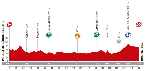
5/ Wednesday 27 August 2014 - Priego de Córdoba > Ronda - 180 km
The 5th stage is yet another flat stage and the profile of the stage between Priego de Córdoba and Ronda indeed shows few altitude variations, except for the end of the stage with the climb of the Puerto El Saltillo, of the 3rd category (12.5 km @ 3.28%) which has its summit at 15.2 km from the finish. The sprinters could thus once more miss the stage victory!Hereunder you'll find the stage itinerary, the profile and the race route on Google Maps for this stage. Click on the images to open them.


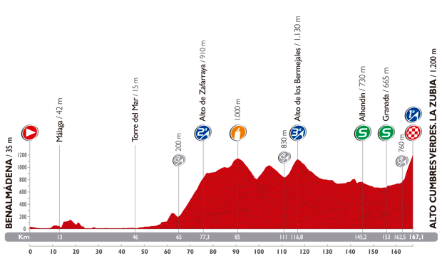
6/ Thursday 28 August 2014 - Benalmádena > La Zubia - 167,1 km
The 6th stage of the Vuelta a España 2014 is the first real mountain stage and in addition to the two 2nd (Alto de Zafarraya, after about 65 kilometers in the race) respectively 3rd category (Alto de Bermejales) climbs, it ends with a mountain top finish, on top of a 1st category climb, Alto Cumbres Verdes (La Zubia), which is short but steep (4.6 km @ 9.57% and going up to 13%).Hereunder you'll find the stage itinerary, the profile and the race route on Google Maps for this stage. Click on the images to open them.


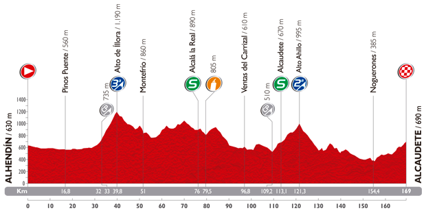
7/ Friday 29 August 2014 - Alhendín > Alcaudete - 169 km
This seventh stage, at the end of the first week of the Tour of Spain 2014, is a middle mountain stage which starts in Alhendín, the perfect occasion for a small breakaway group or a strong solo attacker to try to find the victory in Alcaudete.After about 30 kilometers, the road goes up and at kilometer 39.8 it reaches the summit of the Alto de Íllora (3rd category). The rest of the stage is slightly hilly until the foot of the second climb, the Alto Ahillo of the 2nd category. The final part of the stage is slightly uphill but with an average steepness of 4% any possible breakaway riders probably won't fear it!
Hereunder you'll find the stage itinerary, the profile and the race route on Google Maps for this stage. Click on the images to open them.


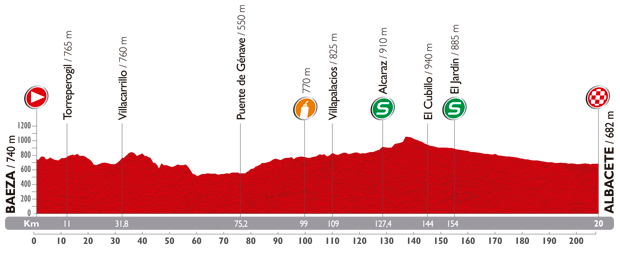
8/ Saturday 30 August 2014 - Baeza > Albacete - 207 km
On Saturday 30 August the race finally leaves the south-west part of Spain where the previous stages turned around a bit, for a stage with quite a surprising profile for a stage on Saturday when the TV audience is usually high. Indeed, a real flat stage is on the programme this Saturday between Baeza and Albacete over almost 210 kilometers. With its 207 kilometers this is however the longest stage of this Vuelta a España 2014.Hereunder you'll find the stage itinerary, the profile and the race route on Google Maps for this stage. Click on the images to open them.


CONTINUE READING AFTER THIS ADVERTISEMENT
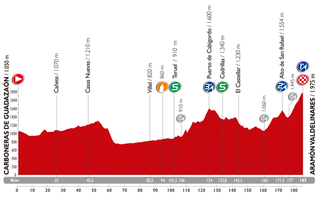
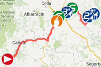
9/ Sunday 31 August 2014 - Carboneras de Guadazaón > Aramón Valdelinares - 185 km
On Sunday, after quite a long transfer, a mountain stage is on the programme, even though this qualification is mainly due to the final climb of the 1st category, towards Aramón Valdelinares. Indeed, the stage starts easily after the start from Carboneras de Guadazaón, with a progressive climb towards Puerto Hontanorio. It won't be before kilometer 124 that the riders arrive on the summit of the first classified climb, the Puerto de Cabigordo (3rd category). Closer to the finish they'll climb the Alto San Rafael (2nd category) and after the descent they'll get on the final climb, over 8 kilometers at 6.62%.Hereunder you'll find the stage itinerary, the profile and the race route on Google Maps for this stage. Click on the images to open them.

R1/ Monday 1er September 2014
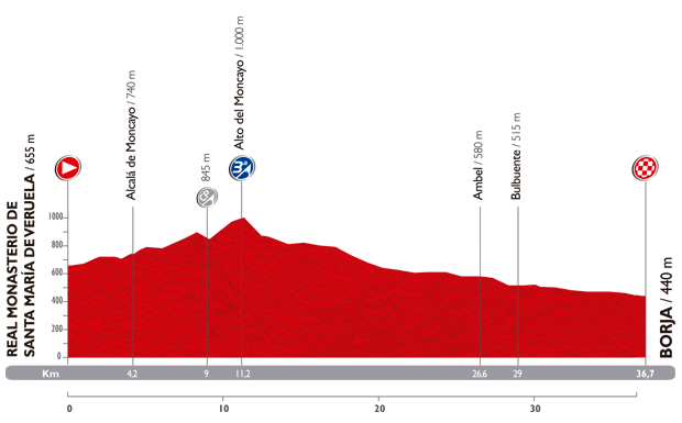
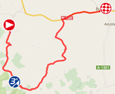
After this first quite intense week, the riders can rest a bit this Monday during the first of the two rest days of this Vuelta a España 2014.10/ Tuesday 2 September 2014 - Real Monasterio de Santa María de Veruel > Borja - individual time trial - 36.7 km
After this well deserved rest, the first individual time trial is planned in this Tour of Spain 2014, over a distance of 36.7 kilometers between Real Monasterio de Santa María de Veruel and Borja. During this stage, each rider will have to climb a 3rd category hill in the first half of this race against the clock, the Alto del Moncayo (2.2 km @ 7.05%), and then descend down to the finish line.Hereunder you'll find the stage itinerary, the profile and the race route on Google Maps for this stage. Click on the images to open them.

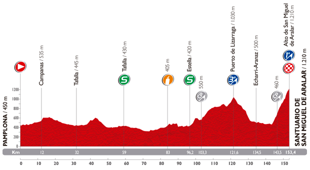
11/ Wednesday 3 September 2014 - Pamplona > Santuario de San Miguel de Aralar - 153,4 km
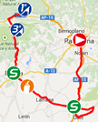
The 11th stage will not be the easiest one after the previous day's time trial, with a profil which starts quite flat but gets harder in the final part of the stage. Indeed, after about one hundred kilometers, the road goes up, first towards the summit of the Puerto de Lizarraga of the 3rd category and after the descent and a short visit of the valley, the riders will start the final climb, towards the Alto San Miguel de Aralar, 1st category climb at the Santuario de San Miguel de Aralar (10.1 km @ 7.43%).Hereunder you'll find the stage itinerary, the profile and the race route on Google Maps for this stage. Click on the images to open them.

CONTINUE READING AFTER THIS ADVERTISEMENT
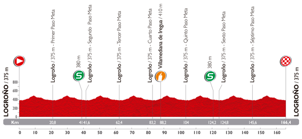
12/ Thursday 4 September 2014 - Logroño > Logroño - 166,4 km
The 12th stage starts and finishes in Logroño and will take place on a circuit of 20.8 kilometers, which the riders will do 8 times. This is thus a stage which is exactly the same as the 5th stage of the Vuelta a España 2012!In 2012 this stage was won in a sprint by John Degenkolb and it's most probable that in 2014 again, this stage ends in a sprint.
Hereunder you'll find the stage itinerary, the profile and the race route on Google Maps for this stage. Click on the images to open them.


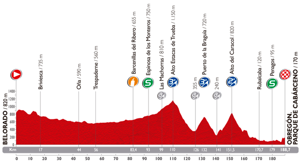
13/ Friday 5 September 2014 - Belorado > Obregón. Parque de Cabárceno - 188,7 km
The 13th stage will take place on Friday 5 September and it'll be a middle mountain stage starting in Belorado.The first half of the stage is rolling but will be followed by a more hilly part. Indeed, two 3rd category climbs will be on the programme, the Alto Estacas de Trueba and the Puerto de la Braguia, which will immediately be followed by a 2nd category climb, the Alto del Caracol. This will be followed by a descent but the final part of the stage is slightly uphill, towards the finish in Obregón at the Parque de Cabárceno.
Hereunder you'll find the stage itinerary, the profile and the race route on Google Maps for this stage. Click on the images to open them.


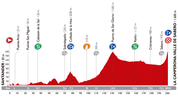
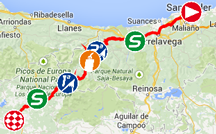
14/ Saturday 6 September 2014 - Santander > La Camperona. Valle de Sabero - 200,8 km
The Saturday of this 3rd weekend of the Vuelta a España 2014 will see a real mountain stage! Furthermore, this will be the second longuest stage of this race.Starting in Santander, the first 60 kilometers of this stage will be quite easy but the riders will then get on the climbs of the Collada de la Hoz (2nd category) and after the descente of this climb, a progressive climb starts towards the foot of the 1st category climb, the Puerto de San Glorio (20.9 km @ 5.72%). Even though the rest of the stage shows a slightly downhill profile, the difficulties are not over yet since the white line will be drawn on top of La Camperona (Valle de Sabero), a first category climb which is quite steep, especially in the last kilometers, going up to 24% (the average steepness is 7.59% over 8.3 km)!
Hereunder you'll find the stage itinerary, the profile and the race route on Google Maps for this stage. Click on the images to open them.

15/ Sunday 7 September 2014 - Oviedo > Lagos de Covadonga - 152,2 km
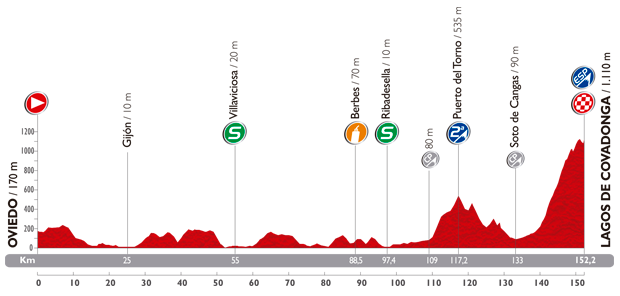
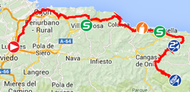
On Sunday another mountain stage is on the programme but this stage has quite a different profile.Indeed, the first 109 kilometers are almost flat, and after that the riders will get on a 2nd category climb, the Puerto del Torno. The descent will be followed by the final climb, towards the first outside category summit of this Tour of Spain 2014, at Lagos de Covadonga (19.2 km @ 5.31%). This climb is not a new one in the Vuelta a España, the last times it was visited was in 2010 and in 2012 for example. In 2012, Ruben Perez arrived 2nd, in a small group with Lloyd Mondory at a bit over 2 minutes behind Antonio Piedra Perez.
Hereunder you'll find the stage itinerary, the profile and the race route on Google Maps for this stage. Click on the images to open them.

CONTINUE READING AFTER THIS ADVERTISEMENT
16/ Monday 8 September 2014 - San Martín del Rey Aurelio > La Farrapona. Lagos de Somiedo - 160,5 km
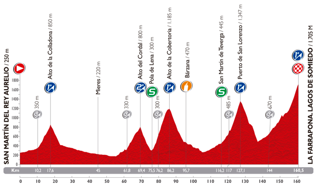
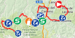
After this mountaineous weekend, the stage on Monday, the 16th stage of the Vuelta a España 2014, will be yet another mountain stage, the day before the second rest day.In this stage, which starts in San Martín del Rey Aurelio, start almost immediately with the climb of the Alto de la Colladona (1st category, 7.5 km @ 6.67%) which summit will be reached after only 17.6 kilometers in the stage. About fourty kilometers slightly downhill will follow this first climb, before the riders get on a second category climb, the Alto del Cordal, which descent immediately goes on in the climb of the Alto de la Cobertoria, a 1st category climb (10 km @ 8.85%). A long descent and a climb, which starts progressively, brings the riders to the foot of the next 1st category climb, the Puerto de San Lorenzo (10.1 km @ 8.53%) and once the summit is reached, the descent will immediately followed by the final climb, 1st category as well, towards the finish iin La Farrapona - Lagos de Somiedo (16.5 km @ 6.27%).
This is clearly the queen stage of this 3 weeks long race, with its 5 first category climbs in a relatively short distance. It is well possible that the final victory of the Vuelta a España 2014 will be decided this day!
Hereunder you'll find the stage itinerary, the profile and the race route on Google Maps for this stage. Click on the images to open them.

R2/ Tuesday 9 September 2014
After this queen stage it's time to enjoy another rest day, before the 5 last stages of this Tour of Spain 2014.17/ Wednesday 10 September 2014 - Ortigueira > A Coruña - 190,7 km
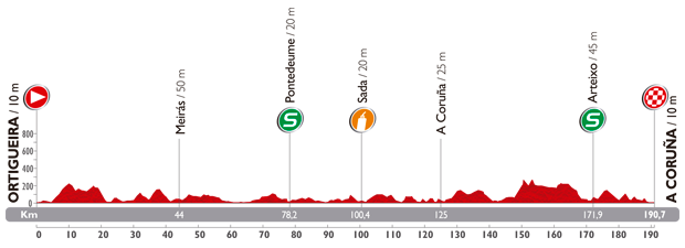
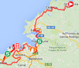
The race will start up again quite easily after this second rest day, and the sprinters who managed to hold on so far, will again get a chance to win a stage. Indeed, between Ortigueira and A Coruña there are some altitude variations but this stage clearly is a flat stage as you can see in the profile below.Hereunder you'll find the stage itinerary, the profile and the race route on Google Maps for this stage. Click on the images to open them.

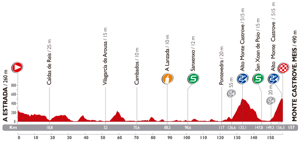
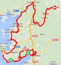
18/ Thursday 11 September 2014 - A Estrada > Monte Castrove. Meis - 157 km
After this easy stage, the 18th stage is again a mountain stage. At first view it doesn't really seem to be a mountain stage but it thanks its classification to the double climb of the Alto Monte Castrove, a 6.5 kilometer long climb going up to 12% (7.08% average), which makes it a 2nd category climb. The riders will do these two climbs in the last 30 kilometers of the stage and the second will lead to the finish of the stage (after a short descent of 700 meters from the top).Hereunder you'll find the stage itinerary, the profile and the race route on Google Maps for this stage. Click on the images to open them.

CONTINUE READING AFTER THIS ADVERTISEMENT
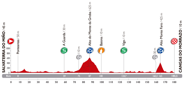
19/ Friday 12 September 2014 - Salvaterra do Miño > Cangas do Morrazo - 180,5 km
We're getting closer to the finish with this middle mountain stage starting in Salvaterra do Miño.In the 180.5 kilometers which seperate the start from the finish in Cangas do Morrazo, the riders will find a first second category climb in the first half of the stage, the Alto do Monte da Groba. Even though this climb could lead to a first selection in the peloton, the second 2nd category climb, the Alto Monte Faro, will probably decide the winner of the stage because its summit is a 15.5 kilometers from the finish line.
Hereunder you'll find the stage itinerary, the profile and the race route on Google Maps for this stage. Click on the images to open them.


20/ Saturday 13 September 2014 - Santo Estevo de Ribas de Sil > Puerto de Ancares - 185,7 km
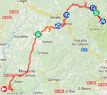
The forelast stage of the Vuelta a España 2014 again has an outside category climb as its final climb, the Puerto de Ancares (12.7 km @ 8.62%). This will not be the only difficulty which makes this stage starting in Santo Estevo de Ribas de Sil a nice mountain stage.Indeed, in the second half of the stage, the follow-up of climbs with the Alto de Vilaesteva (2nd category) and the Alto de O Lago (3rd category) will be followed by a less hilly bit before the riders attack the final part of this stage with a first category climb, the Alto de Folgueiras de Aigas (9.7 km @ 6.70%) and the final climb towards the second outside category summit of this race.
If the general classification is not clear enough at this stage, it'll certainly allow to clearly define the hierarchy of the race or maybe to redefine it, the day before the final time trial.
Hereunder you'll find the stage itinerary, the profile and the race route on Google Maps for this stage. Click on the images to open them.


21/ Sunday 14 September 2014 - Santiago de Compostela > Santiago de Compostela. El Final del Camino - individual time trial - 9.7 km
The end of the road. That's the "subtitle" the organisor of the Vuelta a España gave to this last stage which will be a time trial in Santiago de Compostela!With a relatively short distance (9.7 kilometers) and a completely flat profile, this stage will probably not lead to much changes in the general classification but will probably confirm or finally deliver the name of the winner of the 69th edition of the Tour of Spain, at the end of the road in Santiago de Compostela.
Hereunder you'll find the stage itinerary, the profile and the race route on Google Maps for this stage. Click on the images to open them.


The Tour of Spain 2014 race route in Google Earth
Do you prefer to see the complete Vuelta a España 2014 race route on one map? Or would you like to do a virtual fly-over of the race route of one or more of the stages of this 69th edition of the Tour of Spain? That's all possible, by downloading the following KML file and opening it in Google Earth!>> Download the race route of all stages of the Tour of Spain 2014 in Google Earth

Vond u dit artikel interessant? Laat het uw vrienden op Facebook weten door op de buttons hieronder te klikken!
3 comments | 28729 views
this publication is published in: OpenStreetMap/Google Maps/Google Earth | Vuelta a España | Vuelta a España 2014


 by marco1988 over
Dear Thomas,
A few days ago I could open your Vuelta file in Google Earth but can no longer do so. Is there a problem with the file?
Seems to be working fine now! Thanks for your work on this and other routes on Google Earth.
Hello Hazel,
Sorry for this late reply. There was indeed a problem with the KML files for the Vuelta route during a few hours. This has been resolved rather quickly as you discovered yourself :).