article updated on 27 October 2015 with the videos of the official presentation!
This Tuesday, the race route of the Tour de France 2016, 103rd edition of the Grande Boucle, has been officially presented at the Palais des Congrès by Amaury Sport Organisation (A.S.O.). A race route of 21 stages including 2 individual time trials of which one uphill, which will require the riders who want to be on the top step of the podium to show a good performance during almost the whole Tour!
A nice race route, with quite a lot of new things, that's what A.S.O. offers us for 2016. Let's now discover it in detail!
Christian Prudhomme: "quite a few changes into perspective"!
In the introduction to the race route of the 103rd edition of the Tour de France, Christian Prudhomme, its director, wrote a few words insisting on what's new in this edition's race route. The part which is probably the most interesting in this introduction is what he writes about the mountains:ranges give us far more than just indications: they make a selection.
We’ll see just that in Cantal but also later on in the Jura area when the battle will be on the Col du Grand Colombier. Meanwhile, the stay in the Pyrenees that comes, like in 2015, before the Alps will occur on three days combining innovations and tradition. With our last act, with as many bends as there are climbs, we promise dazzlement, guaranteed by the almost permanent presence of the Mont Blanc (White Mountain). The bets on who will win the Yellow Jersey will be open in Switzerland at Finhaut-Emosson, but also for the return of a mountain time-trial between Sallanches and Megève and why not, on the ultimate descent that the riders will take on as they head to Morzine, 24 hours away from the finish.
Quite a few changes into perspective.
(not my translation, I took the text as officially provided by A.S.O. in their press release)
The Tour de France 2016 in numbers
As usual, the presentation of a Grand Tour's race route starts with an analysis in numbers and of course, the same goes for the Tour de France 2016!The Grand Départ of the Tour de France 2016 in the Manche department
Here's the programme of the Grand Départ in the Manche department:
- Wednesday 29 June 2016: the permanence and press room open in the Pôle Hippique-Haras national de Saint-Lô
- Thursday 30 June 2016: presentation of the teams participating in the Tour de France 2016 in Sainte-Mère-Eglise
- Saturday 2 July 2016: 1st stage - Mont-Saint-Michel > Utah Beach Sainte-Marie-du-Mont
- Sunday 3 July 2016: 2nd stage - Saint-Lô > Cherbourg-Octeville
- Monday 4 July 2016: 3rd stage - start in Granville
The Grand Départ: the Manche department in video
The Tour de France 2016 race route in detail
Let's now have a look at the Tour de France 2016 race route more in detail, visiting all the 21 stages one by one:CONTINUE READING AFTER THIS ADVERTISEMENT
Saturday 02 July 2016 - 1/ Mont-Saint-Michel > Utah Beach Sainte-Marie-du-Mont - 188 km
As we know since a bit over a year now, the first stage of the Tour de France 2016 will start at the Mont-Saint-Michel, which will be a very nice backdrop for the start of this first stage, after having received the Tour de France the last time in 2013 with an individual time trial which finished in front of the Western Marvel.The stage will be flat over 188 kilometers and at the finish a sprinter will be the first to arrive at Utah Beach, one of the landing locations on 6 June 1944 in the city of Sainte-Marie-du-Mont.
Sunday 03 July 2016 - 2/ Saint-Lô > Cherbourg-Octeville - 182 km
For Saint-Lô it'll be the first time they receive the Tour de France, in this case for the start of the 2nd stage. While the stage takes place on a mainly flat road following the west coast up to Cherbourg-Octeville, the new finish on top of the Côte de La Glacerie after 3 kilometers climbing with a maximum of up to 14% could lead to a first shifting among the candidates to final victory or otherwise at least among those who are looking for a stage victory this second day! It is thus well possible that the Yellow Jersey taken in the sprint the day before goes on to the shoulders of another rider after this stage.
Monday 04 July 2016 - 3/ Granville > Angers - 222 km
Between Granville and Angers it'll be the second longest stage of this Tour de France, but it won't be the most difficult one. The riders who were beaten the first day could thus try their chance again in the sprint in front of the Town Hall of the city of Angers!Tuesday 05 July 2016 - 4/ Saumur > Limoges - 232 km
The 4th stage of the Tour de France 2016 starting in Saumur will be the longest stage with its 232 kilometers but since it's a flat stage throughout the Haute-Vienne department, the sprinters will most probably again be celebrating at the finish in Limoges which will be on false flat, again in front of the Town Hall.With this finish, and the stage start the next day, the Tour de France will celebrate the 80th anniversary of Raymond Poulidor who will again be all dressed up in yellow, thanks to LCL, the sponsor of the Tour for which he works.
CONTINUE READING AFTER THIS ADVERTISEMENT
Wednesday 06 July 2016 - 5/ Limoges > Le Lioran - 216 km
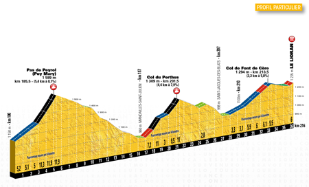
The 5th stage will thus also start in Limoges and will go through Saint-Léonard-de-Noblat where Raymond Poulidor comes from, before it goes off to Le Lioran.Before they get there, the riders will have to climb the Pas de Peyrol (Puy Mary) (^ 1,589 m / 5.4 km @ 8.1%) with its two last kilometers uphill at 12% and after the descent of this climb they'll immediately go on with the climb of the Col de Perthus (^ 1,309 m / 4.4 km @ 7.9%) and before they get to the finish in the station of Le Lioran they'll still have to climb the Col de Font de Cère (^ 1,294 m / 3.3 km @ 5.8%).
As Christian Prudhomme explained, this will be an uninterrupted follow-up of climbs and descents over the last 50 kilometers and the favourites will thus have to show they're ready to fight right from this 5th stage!
Thursday 07 July 2016 - 6/ Arpajon-sur-Cère > Montauban - 187 km
The 6th stage will take place between Arpajon-sur-Cère, just outside Aurillac, and Montauban on a terrain with painful hills but with a final part which is pretty flat and thus offers the last chance for the sprinters to win a stage before they enter the Pyrenees.Friday 08 July 2016 - 7/ L'Isle-Jourdain > Lac de Payolle - 162 km
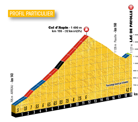
As you know since a few months now since you've been able to follow progressively how we discovered the Tour de France 2016 race route at velowire.com, the non written rule of alternating the mountain chains (Alps/Pyrenees) is not respected between 2015 and 2016 because like this year, the Tour de France 2016 will start with the Pyrenees before it gets to the Alps!And this 7th stage starting in L'Isle-Jourdain will be the first to enter the Pyrenees with the Col d'Aspin (^ 1,490 m / 12 km @ 6.5%) as the only climb of the stage. After the descent of this climb there will still be a few hundreds of meters uphill towards the finish at the Lac de Payolle.
Saturday 09 July 2016 - 8/ Pau > Bagnères-de-Luchon - 183 km
Between the start in Pau, which will exceptionally not start at the Palais Beaumont like the past few years but at the foot of the monument "le Tour des Géants" in the Bois Louis (the totems I talked about when presenting the Tour de France 2015 race route on Google Maps, and the finish in Bagnères-de-Luchon, the riders will start the stage easily, until Luz-Saint-Sauveur after about sixty kilometers. That's where the difficulties will start and there are no less than 4 on the programme: the Col du Tourmalet (^ 2,115 m / 19 km @ 7.4%), the Hourquette d'Ancizan (^ 1,564 m / 8.2 km @ 4.9%), the Col de Val Louron-Azet (^ 1,580 m / 10.7 km @ 6.8%) and finally the Col de Peyresourde (^ 1,569 m / 7.1 km @ 7.8%) of which the descent will bring the riders towards the finish line which has been crossed first twice by Thomas Voeckler in 2010 and 2012 before he was beaten by Michael Rogers in 2014.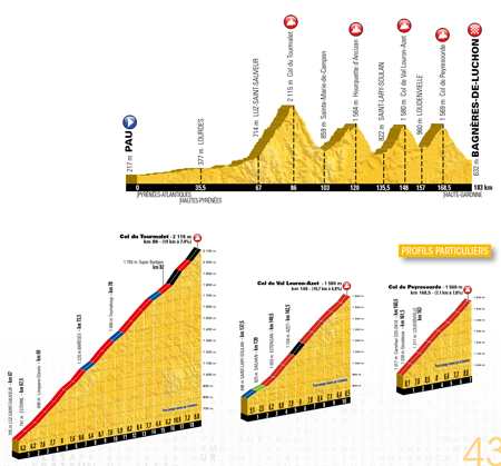
CONTINUE READING AFTER THIS ADVERTISEMENT
Sunday 10 July 2016 - 9/ Vielha (Val d'Aran) (ES) > Andorra Arcalis (AND) - 184 km
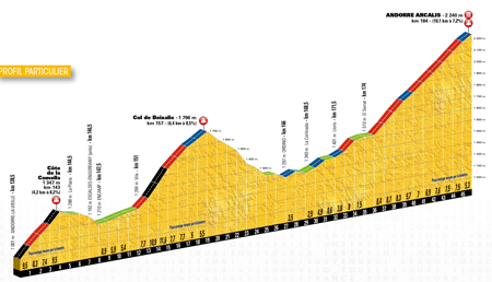
For the 9th stage we'll leave France, with a start in Spain, in Vielha in the Val d'Aran and will be a difficult stage. Indeed, immediately after the start the difficulties will start with the climb of the Port de la Bonaigua (^ 2,072 m / 13.7 km @ 6.1%) and after a flat part in the valley down to Sort, the riders will start the climb of the Col d'El Cantò (^ 1,721 m / 19 km @ 5.4%). Via La Seu d'Urgell they'll enter Andorra and climb via Andorre la Vella to the Côte de la Comella (^ 1,347 m / 4.2 km @ 8.2%). They'll immediately go on with the climb of the Col de Beixalis (^ 1,796 m / 6.4 km @ 8.5%) before the final climb towards Arcalis (^ 2,240 m / 10.1 km @ 7.2%).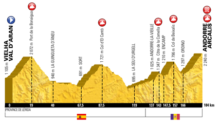
Monday 11 July 2016 - R1/ Andorra
After 9 racing days, the riders can get some rest for the first time in this Grande Boucle, in Andorra!Tuesday 12 July 2016 - 10/ Escaldes-Engordany (AND) > Revel - 198 km
The start of the 10th stage in Andorra will be in Escaldes-Engordany and in order to leave the principality, the riders will climb the Port d'Envalira, which will be the rooftop of the Tour de France 2016 with its 2,409 meters of altitude. Going towards Revel, the riders will find the Côte de Saint-Ferréol on their way, at 6 kilometers from the finish, which can serve as an ideal launchpad for an attacking rider who could be able to win this stage!Wednesday 13 July 2016 - 11/ Carcassonne > Montpellier - 164 km
The 11th stage will start in the Medieval city of Carcassonne and the riders will go off towards Montpellier where the stages usually finish in a sprint and chances are thus high that this will again be the case in 2016.CONTINUE READING AFTER THIS ADVERTISEMENT
Thursday 14 July 2016 - 12/ Montpellier > Mont Ventoux - 185 km
The next day the sprinters really won't be considering they'll have a chance to win the stage when they're at the start in Montpellier. Indeed, when they get to Bédoin they'll have to climb the Mont Ventoux (^ 1,912 m / 15.7 km @ 8.8%) on this national bank holiday.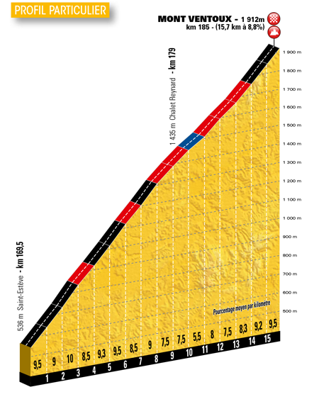
Friday 15 July 2016 - 13/ Bourg-Saint-Andéol > La Caverne du Pont-d'Arc (individual time trial) - 37 km
After the difficult finish at the Mont Ventoux, the legs of each of the riders will have to work individually because they'll have to do an individual time trial between Bourg-Saint-Andéol and La Caverne du Pont-d'Arc, a replica of the Chauvet cave which opened its doors in 2015. The race route in the Ardèche is not completely flat: 6 kilometers @ 5% at the start, about fifteen kilometers flat, a technical descent towards the Gorges de l'Ardèche and finally a 3 kilometer long climb @ 5%.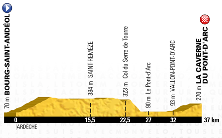
Saturday 16 July 2016 - 14/ Montélimar > Villars-les-Dombes (Parc des Oiseaux) - 208 km
The 14th stage will be a transition stage starting in Montélimar and the sprinters who have correctly managed to keep some forces in the time trial the day before will have the biggest chance for a stage win at the end of the long finish line in front of the Parc des Oiseaux in Villars-les-Dombes.Sunday 17 July 2016 - 15/ Bourg-en-Bresse > Culoz - 159 km
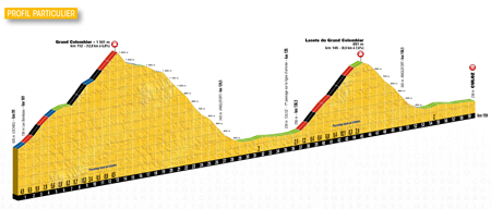
Starting in Bourg-en-Bresse for the 15th stage of the Tour de France 2016, the sprinters will not pretend to have any chances in this stage because after about 20 kilometers they'll already being climbing the Col du Berthiand (^ 780 m / 6 km @ 8.1%). But that's not all because they'll also climb the Col du Sappel (^ 794 m / 8.8 km @ 5.6%) but also the Col de Pisseloup and the Col de la Rochette, before they'll start with the climb of the Grand Colombier (^ 1,501 m / 12.8 km @ 6.8%) and its descent brings them down to the finish line in Culoz but once they've first crossed the finish line they'll do this climb again, this time via the Lacets du Grand Colombier (^ 891 m / 8.4 km @ 7.6%) before they'll redescend towards the finish!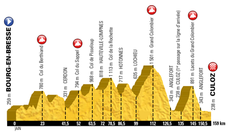
CONTINUE READING AFTER THIS ADVERTISEMENT
Monday 18 July 2016 - 16/ Moirans-en-Montagne > Bern (CH) - 206 km
The 16th stage will give some "rest" to the pure climbers but will not completely simplify the task for the sprinters either. Indeed, if the stage between Moirans-en-Montagne and Berne in Switzerland takes place in the numerous valleys of the Jura, the climb in the urban final part of the stage could break the dreams of the sprinters who didn't have the chance to win a stage so far.Tuesday 19 July 2016 - R2/ Bern (CH)
The second rest day will be in Bern in Switzerland.Wednesday 20 July 2016 - 17/ Bern (CH) > Finhaut-Emosson - 184 km
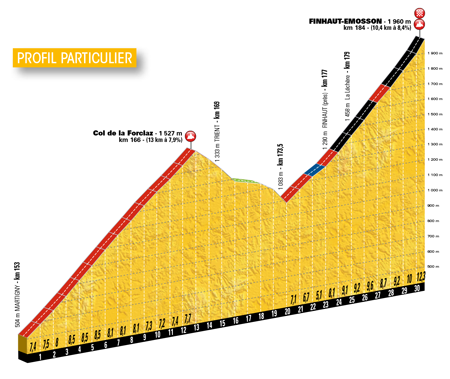
At the start in Berne the riders will start easily down south but in the final part things get rude, with the climb of the Col de la Forclaz (^ 1,445 m / 13 km @ 7.9%) and the final climb towards the barrage of dam of Emosson in Finhaut (^ 1,960 m / 10.4 km @ 8.4%).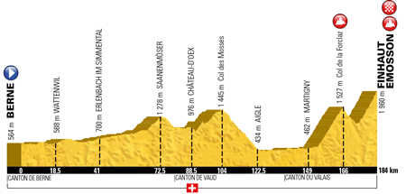
Thursday 21 July 2016 - 18/ Sallanches > Megève (individual time trial) - 17 km
After this mountaineous stage in Switzerland, another individual effort will be on the programme when the race is back in France, but it will still be mountaineous. Indeed, between Sallanches and Megève (which had never received the Tour before!), the Tour de France announces the comeback of the mountain time trial in the Grande Boucle with the Côte de Domancy (^ 810 m / 2.5 km @ 9.4%) followed by a climb towards the Côte des Chozeaux (^ 1,219 m) and the descent towards the finish line in Megève which will be at 1,095 meters of altitude.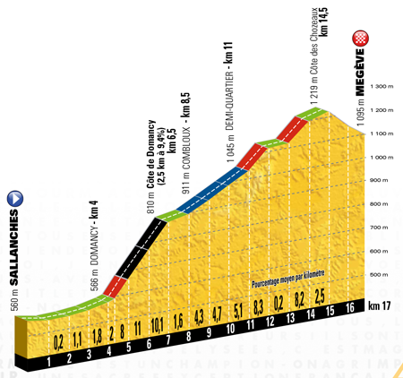
CONTINUE READING AFTER THIS ADVERTISEMENT
Friday 22 July 2016 - 19/ Albertville > Saint-Gervais Mont Blanc - 146 km
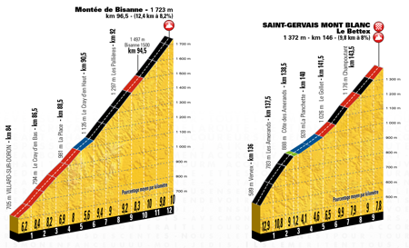
Staying in the region (more precisely coming back to it for the finish), the stage starting in Albertville, Olympic city, will be another mountain stage. Its programme will be made up of the Col de la Forclaz de Montmin (^ 1,157 m / 9.8 km @ 6.9%), the Col de la Forclaz de Queige (^ 870 m / 5.6 km @ 7.8%), the difficult Montée de Bisanne (^ 1,723 m / 12.4 km @ 8.2%) and finally, after a visit of Megève, the final climb towards Saint-Gervais Mont Blanc at an altitude of 1,372 meters after a 9.8 km climb @ 8%.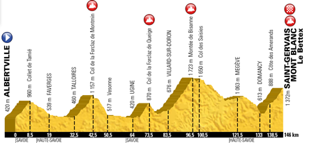
Saturday 23 July 2016 - 20/ Megève > Morzine - 146 km
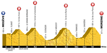
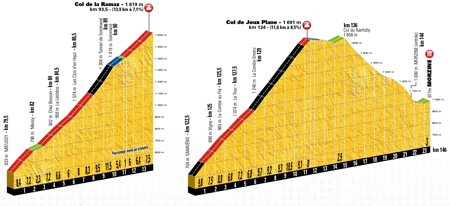
The forelast stage of the Tour de France 2016 will also start in Megève, in what seems like some sort of excuse for the fact that the race has never before visited the station, and will again present a mountaineous profile.Indeed, 146 kilometers seperate the riders from the finish in Morzine which will follow the climbs of the Col des Aravis (^ 1,487 m / 6.7 km @ 7%), (visit of Le Grand-Bornand), Col de la Colombière (^ 1,618 m / 11.7 km @ 5.8%), the Col de la Ramaz (^ 1,619 m / 13.9 km @ 7.1%) and finally the Col de Joux Plane (^ 1,691 m / 11.6 km @ 8.5%).
This stage's race route will also be used for the Etape du Tour, the cyclosportive organised by A.S.O. on the race route of one of the Tour stages!
Here's the race route of this stage in 3D video:
Sunday 24 July 2016 - 21/ Chantilly > Paris Champs-Elysées - 113 km
The very last stage of the Tour de France 2016 will of course finish on the Champs-Elysées in Paris, but what's particular for this stage is that it'll start north of the French capital, for the first time since 1984 (Pantin). This time it'll be in front of the castle of Chantilly.The peloton will enter Paris from the west side and then follow the Avenue de la Grande Armée, go down towards the Seine via the Avenue Marceau, follow the quays and then turn left and pass in front of the Louvre museum to get on with the usual 8 laps on the local circuit!
The stages of the Tour de France 2016
Hereunder you'll find the list of stages of the Tour de France 2016 in a table which strangely looks similar to what velowire.com already told you in the past few days and weeks, based on rumours!The map of the Tour de France 2016
Here's the official map of the Tour de France 2016: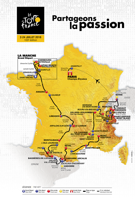
The Tour de France 2016 race route in 3D video
Photos and videos of the presentation of the Tour de France 2016
You can find a few photos of the Tour de France 2016 presentation in the dedicated photo section. You can also check out the videos of the official Tour de France 2016 presentation below. All these videos are available in HD, so please don't hesitate to choose the best available quality to watch them!The introduction by Jean-Etienne Amaury: flashback on 2015
It all started with the introduction by Jean-Etienne Amaury, president of the Amaury group, who talked about the main facts of 2015, and more precisely about the MTN-Qhubeka team and in particular Daniel Teklehaimanot, but also about the broadcasting of the Tour de France on TV in France and abroad and on digital media, but also about the Tour du Yorkshire.His speech was followed by the summary video of the Tour de France 2015 with some very nice images:
CONTINUE READING AFTER THIS ADVERTISEMENT
The introduction by Christian Prudhomme and Philippe Bas
This was followed by an introduction speech by Christian Prudhomme, director of the Tour de France, who started off with the presentation of the visual identity of the Tour de France 2016 to which you can contribute at tdfpassion.fr! In this video, you'll also find the speech by Philippe Bas, the president of the conseil départemental de la Manche, who presented the Grand Départ of the Tour de France 2016 in the Manche!The presentation in detail of the Tour de France 2016 race route by Christian Prudhomme
The time then finally came for the presentation in detail of the Tour de France 2016 race route, after a hint by Christian Prudhomme towards the different "crazy maps" by Le Gruppetto and Sporza and the "very well documented" map by velowire.com :-).Vond u dit artikel interessant? Laat het uw vrienden op Facebook weten door op de buttons hieronder te klikken!
162 comments | 62935 views
this publication is published in: Tour de France | Tour de France 2016


 by marco1988 over
> Utah Beach Sainte-Marie-du-Mont (the finish of the 1st stage)
> Saint-Lô (the start of the 2nd stage)
> Arpajon-sur-Cère (the start of the 6th stage)
> L'Isle-Jourdain and Lac de Payolle (the start and finish of the 7th stage)
> Vielha (Val d'Aran) (the start of the 9th stage)
> Escaldes-Engordany (AND) (the start of the 10th stage)
> Bourg-Saint-Andéol and the Caverne du Pont-d'Arc (the start and finish of the 13th stage)
> Villars-les-Dombes (Parc des Oiseaux) (the finish of the 14th stage)
> Culoz (the finish of the 15th stage)
> Moirans-en-Montagne, a small village of 2,300 inhabitants (the start of the 16th stage)
> Bern (CH) (the finish of the 16th and the start of the 17th stage, but also the location of the second rest day)
> Finhaut-Emosson (CH) (the finish of the 17th stage)
> Megève (the finish of the 18th and the start of the 20th stage)
> Chantilly (the start of the 21st and final stage)