As usual, velowire.com allows you to discover in detail the race route of this 104th edition of the Grande Boucle, on Google Maps/Google Earth at one week before the start of the Tour de France 2017.
With the informations from this article you'll know all the tiny details, all cities and villages the Tour will visit and you'll thus be able to prepare your trip to the race if you're one of the 12 million spectators on the side of the road, or simply be able to follow the race in a better way if you're not!
Some information first ...
Here is some additonal information you need to know before we get into detail about the different stages of the Tour de France 2017:- as for any contents on velowire.com, its reproduction in any form is strictly forbidden, as explained on the copyright page. Please respect the huge amount of time it takes me to produce contents like these!
- the stage profiles have been generated automatically based on altitude information known for the different locations where the stage comes by; there can thus be some incorrect information at some places, but the general profile is still the right one!
- at the moment these maps were being prepared, the Tour de France 2017 roadbook had not been provided to the press yet and all detailed information about the stages (start, feeding zone, finish, ...) are not available on the official website of the race; the information provided here should however be correct anyway since I based it on information I obtained in another way!
The programme of the Grand start of the Tour de France 2017
Here are the dates to remember for this Grand start of the Tour de France 2017:- Wednesday 28 June 2017: opening of the race headquarters at the Messe Düsseldorf Hall n°3 and the press center at the CCD Congress Center Düsseldorf Stadthalle Hall Y
- Thursday 29 June 2017: teams presentation of the Tour de France 2017 on the Burgplatz in Düsseldorf between 6.30PM and 8.00PM: after the general briefing which will take place at 5.30PM at the city hall (Rathaus) of Düsseldorf, the riders will parade by bike along a 1.8km route that will first take them to Burgplatz. This is where the podium will be located and where they will be presented in turn to the public. The parade route will then continue through the streets of the old town and then along the Rhine
- Saturday 1st July 2017: 1st stage - Düsseldorf (DE) > Düsseldorf (DE); a time trial stage of 14 kilometers in the streets of Düsseldorf
- Sunday 2 July 2017: 2nd stage - Düsseldorf (DE) > Liège (BE); this will be a 203.5 kilometers long stage which will mainly take place in Germany but which will end in Belgium
The Tour de France 2017 race route on Google Maps
Let's now discover all the details of the Tour de France 2017 race route, stage per stage:CONTINUE READING AFTER THIS ADVERTISEMENT
1/ Saturday 1st July 2017 - Düsseldorf (DE) > Düsseldorf (DE) - individual time trial - 14 km
The first stage of the Tour de France 2017 will be an individual time trial stage of 14 kilometers.This first stage of the Tour de France 2017 will start in the Stockumer Kirchstraße in Düsseldorf, in front of the Messe. The riders will go off towards the city center of Düsseldorf but they'll first cross the Rhine. Back on the other side of the Rhine they'll get in the city center where they'll find the intermediate timing point in the Königsallee. A bit further, they get back on the same road as on the way down there in order to get back towards the Messe and cross the finish line which will be drawn in the Rotterdamer Straße in Düsseldorf.
Hereunder you'll find the time- and route schedule, the profile and the race route on Google Maps for this stage. Click on the images to open them.


- start : the start will be in front of the Messe in Düsseldorf on the Stockumer Kirchstraße
- climbs : none
- feeding zone : N/A
- intermediate sprint : N/A
- finish : close to the Messe of Düsseldorf in the Rotterdamer Straße
- visited departments : Nordrhein-Westfalen from km 0 till km 14
- main cities : Düsseldorf
2/ Sunday 2 July 2017 - Düsseldorf (DE) > Liège (BE) - 203,5 km
The second stage of the Tour de France 2017 will also start in the city of Düsseldorf and after the official start ceremony on a pedestrian bridge (Füßgängerbrücke) and a visit of the city center, the race will go off towards the first 4th category climb of this Tour de France 2017, the Côte de Grafenberg (1.4 km climbing at 4.5%) before the riders continue east up to the city of Mettmann. They will turn towards Ratingen and back to Düsseldorf and continue this time westwards towards Mönchengladbach where the first intermediate sprint of the race will take place.Direction south from there, via the feeding zone between Titz and Jülich, via Aachen (Aix-la-Chapelle) and once they cross the border with Belgium the climb of the Côte d'Olne of the 4th category (1.3 km climbing at 4.7%).
From there, there will only be about twenty kilometers left towards the first finish of a stage in line of the 104th edition of the Tour de France, in the city center of Liège.
Hereunder you'll find the time- and route schedule, the profile and the race route on Google Maps for this stage. Click on the images to open them.


- start : in Düsseldorf, the start will be on the Burgplatz
- climbs : Côte de Grafenberg (4th, 1,4 km at 4,5%) at km 6,5, Côte d'Olne (4th, 1,3 km at 4,7%) at km 183
- feeding zone : between Titz and Jülich
- intermediate sprint : Bismarckstraße in Mönchengladbach at km 82,5
- finish : Boulevard d'Avroy in Liège
- visited departments : Arrondissement de Düsseldorf from km 0 till km 6,5 and from km 32,5 till km 47,5 and at km 56,5, Arrondissement de Mettmann from km 6,5 till km 32,5, Arrondissement de Rhein-Kreis Neuss from km 56,5 till km 76, Arrondissement de Mönchengladbach from km 76 till km 102,5, Arrondissement de Düren from km 102,5 till km 129,5, Arrondissement d'Aachen from km 129,5 till km 144, Province de Liège from km 144 till km 203,5
- main cities : Düsseldorf, Mönchengladbach, Aachen (Aix-la-Chapelle), Liège
3/ Monday 3 July 2017 - Verviers > Longwy - 212,5 km
The 3rd stage will also start in Belgium, this time in Verviers and the riders will go off straight south towards the finish.Before they get there, they'll have 4 climbs (3 of the 4th and one of the 3rd category) and they'll cross Luxembourg from north to south before they get to the finish in Longwy just after the border with France, and this finish is also a 3rd category climb.
Hereunder you'll find the time- and route schedule, the profile and the race route on Google Maps for this stage. Click on the images to open them.


- start : Rue d'Ensival in Verviers in Belgium; km 0 on the Avenue Reine Astrid (N640)
- climbs : Côte de Sart (4th, 2.8 km climbing at 5.1%) at km 18, Côte de Wiltz (4th, 3.1 km climbing at 4.8%) at km 105,5, Côte d'Eschdorf (3rd, 2.3 km climbing at 9.3%) at km 120,5, Côte de Villers-la-Montagne (4th, 1.1 km climbing at 5.2%) at km 197 and the finish, Côte des Religieuses in Longwy (3rd, 1.6 km climbing at 5.8%) at km 212,5
- feeding zone : Féitsch
- intermediate sprint : N12 in Wincrange at km 89
- finish : D918 / Rue Mercy in Longwy
- visited departments : Province de Liège from km 0 till km 37,5, Province de Luxembourg from km 37,5 till km 67, Luxembourg (Canton de Clervaux, Canton de Wiltz, Canton de Redange, Canton de Capellen) from km 67 till km 181,5, Moselle (57) from km 181,5 till km 184,5 and Meurthe-et-Moselle (54) from km 184,5 till km 212,5
- main cities : Verviers, Stavelot, Trois-Ponts, Vielsalm, Esch-sur-Alzette, Longwy
4/ Tuesday 4 July 2017 - Mondorf-les-Bains (LU) > Vittel - 207,5 km
The 4th stage of the Tour de France 2017 will start just on the other side of the border, in Mondorf-les-Bains in Luxembourg and after having visited Schengen, famous for the treaty which was signed there, the peloton continues its trip to the south during this stage, getting around Metz and Nancy and going on towards Vittel, the thermal city which gives its name to one of the main partners of the Tour.After a short non referenced climb after about fifty kilometers in the race, only one officially referenced difficulty will be on the race route, the Col des Trois Fontaines, but 37 kilometers from the finish this should not prevent the sprinters from winning this stage!
Hereunder you'll find the time- and route schedule, the profile and the race route on Google Maps for this stage. Click on the images to open them.


- start : Avenue Freres Wiesenbach in Mondorf-les-Bains in Luxembourg ; km 0 on the CR152
- climbs : Col des Trois Fontaines (4th, 1.9 km climbing at 7.4%) at km 170,5
- feeding zone : between Blénod-lès-Pont-à-Mousson and Dieulouard
- intermediate sprint : Grande Rue in Goviller
- finish : Avenue Georges Clemenceau in Vittel
- visited departments : Luxembourg (Canton de Remich) from km 0 till km 7,5, Moselle (57) from km 7,5 till km 84,5, Meurthe-et-Moselle (54) from km 84,5 till km 172,5, Vosges (88) from km 172,5 till km 207,5
- main cities : Mondorf-les-Bains, Schengen, Thionville, Vittel
CONTINUE READING AFTER THIS ADVERTISEMENT
5/ Wednesday 5 July 2017 - Vittel > La Planche des Belles Filles - 160,5 km
During the 5th stage of the Tour de France 2017 things will start getting serious because, at the start in the previous day's finish city, Vittel, the first half of the stage will be rather calm, but things will get more difficult in the second half with a climb of the 3rd category, but especially with the finish on top of the Planche-des-Belles-Filles, the 1st category climb which was opened for the first time in the Tour de France in 2012.Hereunder you'll find the time- and route schedule, the profile and the race route on Google Maps for this stage. Click on the images to open them.

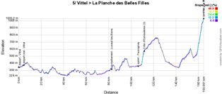

- start : the fictive start will be on the Place de la Marne in Vittel ; km 0 on the D165
- climbs : Côte d'Esmoulières (3rd, 2.3 km climbing at 8%) at km 107,5 and the finish in La Planche-des-Belles-Filles (1st, 5.9 km climbing at 8.5%, with a maximum of 20%) at km 160,5
- feeding zone : Luxeuil-les-Bains
- intermediate sprint : D6 in Faucogney
- finish : on top of La Planche-des-Belles-Filles, at 1032 meters altitude
- visited departments : Vosges (88) from km 0 till km 24,5 and from km 116,5 till km 160,5, Haute-Saône (70) at km 24,5 and at km 116,5
- main cities : Vittel, Luxeuil-les-Bains, La Planche-des-Belles-Filles
6/ Thursday 6 July 2017 - Vesoul > Troyes - 216 km
The 6th stage starting in Vesoul will stop the trip straight south for a short excursion westwards.The two short climbs the riders will find on their way will probably not prevent the sprinters to battle for victory at the finish in Troyes!
Hereunder you'll find the time- and route schedule, the profile and the race route on Google Maps for this stage. Click on the images to open them.


- start : Place de la République in Vesoul ; km 0 on the D13
- climbs : two difficulties are on the programme : the Côte de Langres (4th, 1.3 km climbing at 6.3%) at km 69 and the Côte de la colline Sainte-Germaine (4th, 3.1 km climbing at 4.4%) at km 154
- feeding zone : Chaumont
- intermediate sprint : D619 / Route de Colombey-les-deux-églises in Colombey-les-Deux-Églises at km 135
- finish : Boulevard du 1er Régiment d'Artillerie de Marine in Troyes
- visited departments : Haute-Saône (70) from km 0 till km 37, Haute-Marne (52) from km 37 till km 138,5, Aube (10) from km 138,5 till km 216
- main cities : Vesoul, Langres, Chaumont, Troyes
7/ Friday 7 July 2017 - Troyes > Nuits-Saint-Georges - 213,5 km
It's as if we went back on our steps with this short sidetrip to Troyes because the next day the race continues towards Nuit-Saint-Georges, at less than 130 kilometers as the crow flies from Vesoul.Normally this would again be a sprinters stage but the organisor of the Tour mentions a final circuit of 40 kilometers which could expose the peloton to side winds which certain teams perfectly know how to use. Actually, there's no circuit which would make one think of two crossings of the finish line for example but just a detour around the finish city.
Hereunder you'll find the time- and route schedule, the profile and the race route on Google Maps for this stage. Click on the images to open them.


- start : Boulevard Victor Hugo in Troyes ; km 0 on the D49
- climbs : Côte d'Urcy (4th, 2.5 km climbing at 4.2%) at km 147,5
- feeding zone : on the D971 between Champagny and Saint-Seine-l'Abbaye
- intermediate sprint : on the D971 in Chanceaux at km 108
- finish : on the Route de Beaune in Nuits-Saint-Georges
- visited departments : Aube (10) from km 0 till km 47, Côte-d'Or (21) from km 47 till km 213,5
- main cities : Troyes, Bar-sur-Seine, Châtillon-sur-Seine, Nuits-Saint-Georges
8/ Saturday 8 July 2017 - Dole > Station des Rousses - 187,5 km
The Jura massive offers the riders several difficulties in this stage and it'll most probably thus be a strong rider who will win the stage in a solo escape or a small breakaway group at the finish in the Station des Rousses which the Tour de France visited for the last time in 2010. Will we see the painting which was realised at that occasion and which you can see in the photo next to this text when it was being realised? (click on it to see a bigger version of it)
Hereunder you'll find the time- and route schedule, the profile and the race route on Google Maps for this stage. Click on the images to open them.

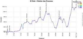

- start : Avenue de Lahr in Dole ; km 0 on the D7
- climbs : Col de la Joux (3rd, 6.1 km climbing at 4.7%) at km 101,5, Côte de Viry (2nd, 7.6 km climbing at 5.2%) at km 138,5, Montée de la Combe de Laisia Les Molunes (1st, 11.7 km climbing at 6.4%) at km 175,5
- feeding zone : on the D678 in Bonlieu
- intermediate sprint : N5 in Montrond at km 45,5
- finish : Route de Prémanon in the Station des Rousses
- visited departments : Jura (39) from km 0 till km 187,5
- main cities : Dole, Arbois, Champagnole, Clairvaux-les-Lacs, Station des Rousses
CONTINUE READING AFTER THIS ADVERTISEMENT
9/ Sunday 9 July 2017 - Nantua > Chambéry - 181,5 km
Still in the Jura and going off towards the Alps, the start of this 9th stage will be in Nantua close to its famous lake. It'll be the first time that Nantua receives the Tour de France. This is not the case for Chambéry where the Tour had a stage start in 1996 and another one in 2010. In 2017 it'll be for a stage finish that the race goes off towards the base camp of the AG2R La Mondiale team.It'll be quite a mountaineous stage with the climb of the Côte des Neyrolles rapidly after the start in Nantua, the Col de la Biche (Croix de Famban) about fifty kilometers further, immediately followed by the ckimb of the most difficult side of the Grand Colombier. Before they arrive in Chambéry, the riders will still have the Mont du Chat to climb, a difficult climb which had only once before been part of the Tour de France race route (in 1974!). From there, the riders will go down towards Le Bourget-du-Lac and finally a bit over 12 kilometers towards the finish line in Chambéry.
Hereunder you'll find the time- and route schedule, the profile and the race route on Google Maps for this stage. Click on the images to open them.

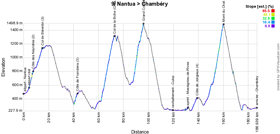

- start : on the Avenue du Lac in Nantua ; km 0 on the D55D
- climbs : Côte des Neyrolles (2nd, 3.2 km climbing at 7.2%) at km 3,5, Col de Bérentin (3rd, 4.1 km climbing at 6.1%) at km 11, Côte de Franclens (3rd, 2.4 km climbing at 6%) at km 38, Col de la Biche (Croix de Famban) (HC, 10.5 km climbing at 9%) at km 67,5, Grand Colombier (HC, 8.5 km climbing at 9.9%) at km 91, Côte de Jongieux (4th, 3.9 km climbing at 4.2%) at km 134, Mont du Chat (HC, 8.7 km climbing at 10.3%) at km 155,5
- feeding zone : on the D992 in Culoz
- intermediate sprint : on the D37 in Massignieu-de-Rives at km 126,5
- finish : Quai des Allobroges in Chambéry
- visited departments : Ain (01) from km 0 till km 35,5 and from km 50 till km 181,5, Haute-Savoie (74) from km 35,5 till km 50
- main cities : Nantua, Seyssel, Culoz, Bourget-du-Lac, La Motte-Servolex, Chambéry
R1/ Monday 10 July 2017 - rest day in the Dordogne department
After this stage finish in Chambéry, the riders will enjoy the first rest day of this Tour de France 2017 in Dordogne the next day, while the followers will drive all the kilometers to get there ...10/ Tuesday 11 July 2017 - Périgueux > Bergerac - 178 km
The day after the first rest day, the start will take place in Périgueux. Already 3 times visited by the Tour previously, the city of Périgueux will for the first time see the Tour de France for a stage in line instead of a time trial as was previously the case.It'll most probably be a sprint which will finish off the stage 178 kilometers further, in Bergerac, after having visited Montignac and the replica of the Lascaux cave.
Hereunder you'll find the time- and route schedule, the profile and the race route on Google Maps for this stage. Click on the images to open them.


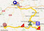
- start : Cours Tourny in Périgueux ; km 0 on the N221
- climbs : Côte de Domme (4th, 3.5 km climbing at 3.3%) at km 100,5 and Côte du Buisson-de-Cadouin (4th, 2.1 km climbing at 5.6%) at km 138,5
- feeding zone : between Sarlat-la-Canéda and Vitrac
- intermediate sprint : D703 / voie de la Vallée in Saint-Cyprien at km 121
- finish : Allée Lucien Videau in Bergerac
- visited departments : Dordogne (24) from km 0 till km 178
- main cities : Périgueux, Montignac, Sarlat-la-Canéda, Domme, Bergerac
11/ Wednesday 12 July 2017 - Eymet > Pau - 203,5 km
Another transition stage for the sprinters before the Pyrenees show up, and it'll take place between Eymet, a small town in the Dordogne of 3,500 inhabitants which will see the Tour for the first time, and Pau, must more used to see the Tour de France because the city in the Pyrénées-Atlantiques will be for the 69th time on the map of the Tour de France in 2017!!Hereunder you'll find the time- and route schedule, the profile and the race route on Google Maps for this stage. Click on the images to open them.


- start : D933 / Boulevard National in Eymet ; km 0 on the D933
- climbs : Côte d'Aire-sur-l'Adour (4th, 1.2 km climbing at 4.2%) at km 145,5
- feeding zone : on the D626 in Labastide-d'Armagnac
- intermediate sprint : D2 in Aire-sur-l'Adour at km 142,5
- finish : Place de Verdun / Rue du Maquis du Béarn in Pau
- visited departments : Dordogne (24) from km 0 till km 71,5, Landes (40) from km 71,5 till km 106,5 and from km 135 till km 149,5 and from km 152,5 till km 156,5, Gers (32) from km 106,5 till km 135 and at km 152,5, Pyrénées-Atlantiques (64) from km 156,5 till km 203,5
- main cities : Eymet, Marmanda, Casteljaloux, Aire-sur-l'Adour, Pau
CONTINUE READING AFTER THIS ADVERTISEMENT
12/ Thursday 13 July 2017 - Pau > Peyragudes - 214,5 km
Pau will also be the start city of the 12th stage, as it's often the case, and this time that'll be for a 214.5 kilometers long stage, the first Pyrenean stage and also the longest stage in the Pyrenees of this 104th Tour towards the station of Peyragudes.Even though the first half of the stage is relatively simple, it is halfway that things start get more complicated, with the climb of the Col des Ares followed a bit further by the Col de Menté anf closer to the finish by the climb of the Port de Balès. We'll already be at 30 kilometers from the finish at that time, and those are downhill over 16 kilometers followed by the 9.7 kilometers of the climb of the Col de Peyresourde, a short descent of a bit over 2 kilometers and the final climb towards Peyragudes over 2.4 km .
The finish will be for the first time in the history of the Tour at the unique altiport of the Pyrenees, which the riders get onto via a last kilometer which contains a part at 16% over 200 meters!
Hereunder you'll find the time- and route schedule, the profile and the race route on Google Maps for this stage. Click on the images to open them.

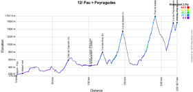
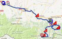
- start : Avenue Gaston Lacoste in Pau, this will not be the usual start in Pau ; km 0 on the D817
- climbs : Côte de Capvern (4th, 7.7 km climbing at 3.1%) at km 64, Col des Ares (2nd, 7.4 km climbing at 4.6%) at km 111,5, Col de Menté (1st, 6.9 km climbing at 8.1%) at km 139,5, Port de Balès (HC, 11.7 km climbing at 7.7%) at km 184, Col de Peyresourde (1st, 9.7 km climbing at 7.8%) at km 209,5 and the finish in Peyragudes (2nd, 2.4 km climbing at 8.4%) at km 214,5
- feeding zone : on the N125 between Luscan and Galié
- intermediate sprint : rue Nationale in Loures-Barousse at km 94
- finish : at the altiport of Peyragudes
- visited departments : Pyrénées-Atlantiques (64) from km 0 till km 11 and at km 19,5, Hautes-Pyrénées (65) at km 15 and from km 19,5 till km 87,5 and from km 91 till km 94,5 and from km 156 till km 184 and from km 209,5 till km 214,5, Haute-Garonne (31) from km 87,5 till km 91 and from km 94,5 till km 156 and from km 184 till km 209,5
- main cities : Pau, Tarbes, Lannemezan (près), Peyragudes
13/ Friday 14 July 2017 - Saint-Girons > Foix - 101 km
The 13th stage of the Tour de France 2017 which will take place on Friday 14 July, National bank holiday in France, is extremely short, with its 101 kilometers it'll be the shortest stage in line of this Tour, even shorter than the last one which finishes in Paris!That doesn't mean however that it'll be an easy stage, because between the start in Foix and the finish in Saint-Girons, it'll be animated by 3 difficulties with some very difficult parts. These will be the Col de Latrape, the Col d'Agnes and finally the Mur de Péguère which pretty well respects its new name ("mur" for "wall") which A.S.O. gave it during the last visit of the Tour in 2012 with its steepness going up to 18%!
Hereunder you'll find the time- and route schedule, the profile and the race route on Google Maps for this stage. Click on the images to open them.

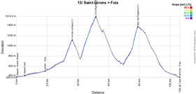
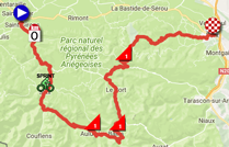
- start : D3 / Boulevard Frédéric Arnaud in Saint-Girons
- climbs : Col de Latrape (1st, 5.6 km climbing at 7.3%) at km 31, Col d'Agnes (1st, 10 km climbing at 8.2%) at km 46,5 and Mur de Péguère (1st, 9.3 km climbing at 7.9%) at km 74
- feeding zone : non applicable
- intermediate sprint : D3 / Avenue de la Barraqué in Seix at km 13,5
- finish : D117C / Allée de Villote in Foix
- visited departments : Ariège (09) from km 0 till km 101
- main cities : Saint-Girons, Seix, Aulus-les-Bains, Foix
14/ Saturday 15 July 2017 - Blagnac > Rodez - 181,5 km
This 14th stage starting in Blagnac will be a transition stage without much interest unless a puncher will use the Côte Saint-Pierre in Rodez to create a surprise?Hereunder you'll find the time- and route schedule, the profile and the race route on Google Maps for this stage. Click on the images to open them.

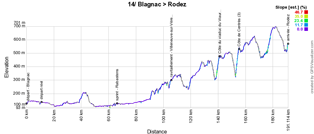
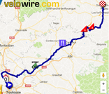
- start : Allée du Canalet in Blagnac ; km 0 on the D2
- climbs : Côte du viaduc du Viaur (3rd, 2.3 km climbing at 7%) at km 131, Côte de Centrès (3rd, 2.3 km climbing at 7.7%) at km 145
- feeding zone : on the D3 between Villeneuve-sur-Vère and Mailhoc
- intermediate sprint : D988 / Avenue de Toulouse in Rabastens at km 55,5
- finish : D84 / Avenue de Saint-Pierre in Rodez
- visited departments : Haute-Garonne (31) from km 0 till km 45,5, Tarn (81) from km 45,5 till km 127,5, Aveyron (12) from km 127,5 till km 181,5
- main cities : Blagnac, Gaillac, Carmaux, Rodez
15/ Sunday 16 July 2017 - Laissac-Sévérac l'Eglise > Le Puy-en-Velay - 189,5 km
In the village of Laissac, with only 2,100 habitants, the venue of the Tour will be a big event because never before the Grande Boucle went here and the village is mostly known for mountain biking.Crossing the Aubrac heights, the riders will climb the Montée de Naves d'Aubrac and stay on the heights above 1000 meters altitude for about one hundred kilometers before they get back down, towards the foot of the Col de Peyra Taillade which contains a part going up to 14% and which was never before part of the Tour de France. The riders will then descend towards Le Puy-en-Velay where a breakaway could stay ahead for the stage victory!
Hereunder you'll find the time- and route schedule, the profile and the race route on Google Maps for this stage. Click on the images to open them.

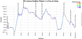
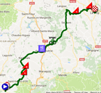
- start : Place du Foirail in Laissac-Sévérac l'Eglise ; km 0 on the D45
- climbs : Montée de Naves d'Aubrac (1st, 8.9 km climbing at 6.4%) at km 28,5, Côte de Vieurals (3rd, 3.3 km climbing at 5.9%) at km 43,5, Col de Peyra Taillade (1st, 8.3 km climbing at 7.4%) at km 158, Côte de Saint-Vidal (4th, 1.9 km climbing at 6.8%) at km 176,5
- feeding zone : on the D987 between Le Chaze-de-Peyre (Peyre-en-Aubrac) and Aumont-Aubrac
- intermediate sprint : D987 / avenue de Saint-Chély-d'Apcher in Saint-Alban-sur-Limagnole at km 96
- finish : N102 / Place du Breuil in Le Puy-en-Velay
- visited departments : Aveyron (12) from km 0 till km 52, Lozère (48) from km 51 till km 105,5, Haute-Loire (43) from km 105,5 till km 189,5
- main cities : Laissac-Sévérac l'Eglise, Aumont-Aubrac, Le Puy-en-Velay
CONTINUE READING AFTER THIS ADVERTISEMENT
R2/ Monday 17 July 2017 - Le Puy-en-Velay
After this stage, the riders will enjoy the second rest day, this time without any transfer, in Le Puy-en-Velay.16/ Tuesday 18 July 2017 - Le Puy-en-Velay > Romans-sur-Isère - 165 km
After the rest day, the start of this 16th stage will also take place in Le Puy-en-Velay. This will be a stage towards Romans-sur-Isère in which everything is possible if we believe the comments from Christian Prudhomme, the director of the Tour de France, since he wrote: The roads of the day are perfectly known by the amateur riders of the Ardéchoise cyclosportive, with a topography that could give confidence to breakaway riders. But finishes in the Rhône Valley often end up with bunched sprints ... unless the wind plays a role..Hereunder you'll find the time- and route schedule, the profile and the race route on Google Maps for this stage. Click on the images to open them.

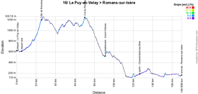

- start : N102 / Place du Breuil in Le Puy-en-Velay ; km 0 on the D535
- climbs : Côte de Boussoulet (3rd, 4.5 km climbing at 6.3%) at km 20,5 and Col du Rouvey (4th, 2.8 km climbing at 5.6%) at km 65
- feeding zone : on the D532 in Saint-Félicien
- intermediate sprint : D109 in Chantemerle-les-Blés at km 121,5
- finish : D532 / Place Jean Jaurès in Romans-sur-Isère
- visited departments : Haute-Loire (43) from km 0 till km 41 and at km 57,5, Ardèche (07) from km 41 till km 55,5 and from km 57,5 till km 109, Drôme (26) from km 109 till km 165
- main cities : Le Puy-en-Velay, Le Chambon-sur-Lignon, Saint-Félicien, Romans-sur-Isère
17/ Wednesday 19 July 2017 - La Mure > Serre-Chevalier - 183 km
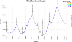
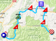
From La Mure, a never before visited stage city in the Tour de France, we finally really get into the Alps for a stage with no less than 4 difficulties.Indeed, it all starts with the climb of the Col d'Ornon, followed a bit further by the Col de la Croix de Fer and after a bit in the valley via Saint-Jean-de-Maurienne, they'll start the climb of the Col du Télégraphe which will continue in the climb of the Col du Galibier. The descent of the last mentioned climb will bring them to the finish in Serre-Chevalier.
Hereunder you'll find the time- and route schedule, the profile and the race route on Google Maps for this stage. Click on the images to open them.

- start : Avenue Chion Ducollet in La Mure ; km 0 on the D26
- climbs : Col d'Ornon (2nd, 5.1 km climbing at 6.7%) at km 30, Col de la Croix de Fer (HC, 24 km climbing at 5.2%) at km 78,5, Col du Télégraphe (1st, 11.9 km climbing at 7.1%) at km 132,5 and the Col du Galibier (HC, 17.7 km climbing at 6.9%) at km 155 which will be the rooftop of the Tour de France 2017 and on top of which the Souvenir Henri Desgrange will be attributed
- feeding zone : on the D1006 in Saint-Julien-Mont-Denis
- intermediate sprint : D526 / route de Savoie in Allemont at km 47,5
- finish : Route de Bez in Serre-Chevalier
- visited departments : Isère (38) from km 0 till km 69,5, Savoie (73) from km 69,5 till km 155, Hautes-Alpes (05) from km 155 till km 183
- main cities : La Mure, Allemont, Fontcouverte-La Toussuire, Saint-Jean-de-Maurienne, Saint-Michel-de-Maurienne, Valloire, Serre-Chevalier
18/ Thursday 20 July 2017 - Briançon > Izoard - 179,5 km
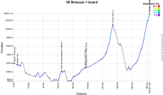
The second Alps stage will start in Briançon and will go towards Embrun and Barcelonnette, followed by the climb of the Col de Vars followed by the final climb towards the Col d'Izoard, col which has never seen a stage finish of the Tour before.Hereunder you'll find the time- and route schedule, the profile and the race route on Google Maps for this stage. Click on the images to open them.


- start : Avenue Jean Moulin in Briançon ; km 0 on the N94
- climbs : Côte des Demoiselles Coiffées (3rd, 3.9 km climbing at 5.2%) at km 60, Col de Vars (1st, 9.3 km climbing at 7.5%) at km 129,5 and the final climb of the Col d'Izoard (HC, 14.1 km climbing at 7.3%) at km 179,5
- feeding zone : on the D900 in Saint-Pons
- intermediate sprint : on the D900 in Les Thuiles
- finish : on top of the Izoard
- visited departments : Hautes-Alpes (05) from km 0 till km 55,5 and from km 60 till km 67 and from km 129,5 till km 179,5, Alpes-de-Haute-Provence (04) from km 55,5 till km 60 and from km 67 till km 129,5
- main cities : Briançon, Embrun, Barcelonnette, Vars, Risoul, Col d'Izoard
CONTINUE READING AFTER THIS ADVERTISEMENT
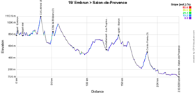
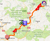
19/ Friday 21 July 2017 - Embrun > Salon-de-Provence - 222,5 km
Leaving the Alps, the peloton will get back together for the start of the longuest stage of this Tour de France 2017 in Embrun, towards Salon-de-Provence. The start of this stage will be hilly and thus quite difficult, which could lead to a breakaway being formed. But will this breakaway be able to continue till the finish ...?Hereunder you'll find the time- and route schedule, the profile and the race route on Google Maps for this stage. Click on the images to open them.

- start : Avenue des Acacias in Embrun ; km 0 on the N94
- climbs : Col Lebraut (3rd, 4.7 km climbing at 6%) at km 26, Côte de Bréziers (3rd, 2.3 km climbing at 5.8%) at km 43, Col du Pointu (3rd, 5.8 km climbing at 4.1%) at km 177,5
- feeding zone : on the D13 between Les Fugons and Ongles
- intermediate sprint : D950 in Banon at km 136,5
- finish : Boulevard du Maréchal Foch in Salon-de-Provence
- visited departments : Hautes-Alpes (05) from km 0 till km 43,5, Alpes-de-Haute-Provence (04) from km 43,5 till km 146,5, Vaucluse (84) from km 146,5 till km 205, Bouches-du-Rhône (13) from km 205 till km 222,5
- main cities : Embrun, Sisteron, Salon-de-Provence
20/ Saturday 22 July 2017 - Marseille > Marseille - individual time trial - 22,5 km
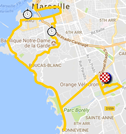
The forelast stage of the Tour de France 2017 will completely take place in the streets of Marseille where the start and the finish of this solitary test will both take place in the Orange Vélodrome, the stadium of Olympique Marseille which recently changed its name thanks to a sponsoring by Orange, which is also one of the sponsors of the Tour.In 2017, Marseille will be the European capital of sports and this time trial is thus part of it, even though it obliges the followers of the Tour to travel a huge distance in order to get back close to Paris, in a weekend where the holidays start.
The race route will be relatively flat, the riders will just have to climb a bit at the Basilique Notre-Dame de la Garde where we'll also find one of the two intermediate timing points (the other one will be at the Palais du Pharo just before the riders visit the Vieux Port).
Hereunder you'll find the time- and route schedule, the profile and the race route on Google Maps for this stage. Click on the images to open them.


- start : Orange Vélodrome in Marseille
- climbs : aucun
- feeding zone : non applicable
- intermediate sprint : non applicable
- finish : Orange Vélodrome in Marseille
- visited departments : Bouches-du-Rhone (13) from km 0 till km 22,5
- main cities : Marseille
21/ Sunday 23 July 2017 - Montgeron > Paris Champs-Elysées - 103 km
One the riders get to Paris, the usual circuit on the Champs-Elysées will be on the programme 8 times, but before they get there, they'll get for the first time in the Grand Palais which they'll cross through the "grand nef"!
On the race route of this stage, the riders will come by the headquarters of at least two sponsors of the Tour de France: Orange in Arcueil and France Télévisions in Paris.
Hereunder you'll find the time- and route schedule, the profile and the race route on Google Maps for this stage. Click on the images to open them.


- start : Avenue Charles de Gaulle in Montgeron ; km 0 on the N6 ; the riders will come by in front of the Réveil Matin, the famous bar where the very first Tour de France started in 1903, but they'll not stop there
- climbs : none
- feeding zone : none
- intermediate sprint : Paris, on the Champs-Elysées at km 63,5 just after the 3rd crossing of the finish line
- finish : Avenue des Champs-Elysées in Paris
- visited departments : Essonne (91) till km 0 and from km 3,5 till km 23,5, Val-de-Marne (94) from km 0,5 till km 3,5 and from km 30 till km 31,5, Hauts-de-Seine (92) from km 23,5 till km 30 and till km 32,5, Paris (75) from km 34 till km 103
- main cities : Montgeron, Viry-Châtillon, Longjumeau, Antony, Arcueil, Montrouge, Paris
The Tour de France 2017 race route in Google Earth
Do you prefer to see the full Tour de France 2017 race route on a single map? Or would you like to do a virtual fly-over of the race route of one or more stages of this 104th edition of the Tour de France? That's all possible, by downloading the KMZ file (a ZIPped KML file, because of its big size) hereunder and by opening it in Google Earth! ATTENTION - copyright: even though this KMZ file is provided for free for your own use, please note that it's strictly forbidden to reproduce the contents of this KMZ file or of any other file (including the maps, the profiles, the KML files and others) which make up the Tour de France 2017 race route. These contents are indeed protected by copyright and I'd thus ask you to respect the huge amount of time I spend on the creation of it. This protection concerns the reproduction of the maps or other elements in no matter which way (as a map, a video which flies over the map or any other creation based on the contents published on velowire.com).
>> Download the race route of all stages of the Tour de France 2017 in Google Earth (KMZ file, 331 kB)

Vond u dit artikel interessant? Laat het uw vrienden op Facebook weten door op de buttons hieronder te klikken!
13 comments | 66923 views
this publication is published in: Tour de France | Tour de France 2017 | OpenStreetMap/Google Maps/Google Earth


 by marco1988 over