tuesday 29 November 2011 at 00h01
velowire.com continues announcing new rumours about the Tour de France 2012. Today it's the turn for the 2nd stage of the 99th edition of the Tour de France to be presented. Indeed, thanks to a regular reader of this web site, you can find all informations about the detailed race course of this stage between Visé and Tournai in Belgium in this article, including an interactive Google Maps version of the race route.
Go discover!
The 3 first stages of the Tour de France 2012
The Tour de France 2012 will start with a prologue and 2 stages in line in Belgium.CONTINUE READING AFTER THIS ADVERTISEMENT
Saturday 30 June 2012 - prologue in Liège - 6,1 km
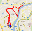
The prologue of the Tour de France 2012 will take place in the city of Liège over a distance of 6.1 kilometers.The gathering location of this prologue will be in the Parc d'Avroy with the start podium in the Avenue Rogier. The race route will be completely flat and identical to the one used in 2004 when the Swiss rider Fabian Cancellara took the first yellow jersey.
The riders will than continue north on the Boulevard d'Avroy and the Boulevard de la Sauvenière before they arrive on the Quai Roosevelt following the Meuse river. They will turn left at la Batte (after a bit more than 3 kilometers) towards the Place Saint-Lambert and its Palais des Princes-Évêques. They'll than follow the Boulevard de la Sauvenière and the Boulevard d'Avroy in the opposite direction towards the finish line where they'll get after 6.1 kilometers.
Hereunder you'll find the profile and the Google Maps version of the race route of this stage. Click on each of the images to open them.


1/ Sunday 1st of July 2012: Liège > Seraing - 198 km
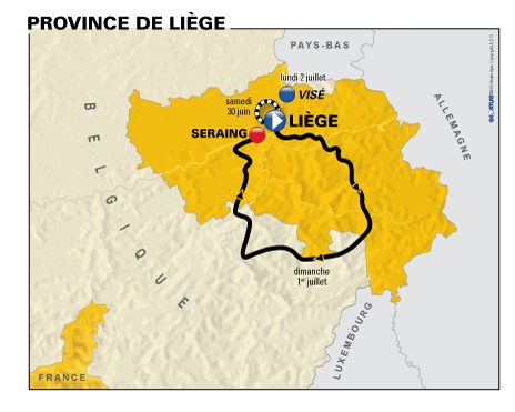
The first stage, over a distance of 198 kilometers, will also start from the Parc d'Avroy. However, as usual an official start ceremony will take place a bit further on, at the Place Saint-Lambert in front of the Palais des Princes-Évêques which the riders will have seen already the day before during the prologue (well, it's not sure they really pay attention to that during the race!).This stage's route will be hilly and will follow the roads which are usually used for the spring classics. The 198 kilometer distance is obtained by going down to the south-east limit of the Province of Liège while visiting Spa-Francorchamps where the riders will be close to the famous car race circuit. After a short visit of the Province of Luxembourg, via the Baraque de Fraiture, which is one of the highest points of Belgium with its 652 meter altitude, and Hotton, the riders will go back north towards the finish in Seraing which will be in front of the Cristalleries du Val Saint-Lambert preceded by a 2 kilometer long climb of which 600 meters will be at 8% and with a maximum steepness of 14%.

CONTINUE READING AFTER THIS ADVERTISEMENT
2/ Monday 2 July 2012: Visé > Tournai - 207 km
For the second stage on Monday 2 July 2012, ASO hasn't given out much information yet, except that it will be a 207 kilometer long stage between Visé and Tournai.However, a regular reader of this web site sent me information about this stage after having read several Belgian newspapers about this stage (including mainly DH, l'Avenir, le Soir, la RTBF, ...) and the information he found in the 22 November 2011 edition of Nord-Eclair (group SudPresse, Tournai edition).
Since the information he provided was so precise, I was able, combining this information with the map shown in the video of the presentation of the stages by Christian Prudhomme, to build up a Google Maps version of this stage.
After the start from Visé, the riders will go south-east to Namur where they'll climb the Citadelle de Namur which for example is the finish location of the Grand Prix de Wallonie and which also appears in the Le Vélo de Ghislain Lambert movie.
After that, they'll continue north-west towards Nivelles from where they'll continue towards Soignies and than go via Ghislenghien, where the intermediate sprint will probably be set up, towards the finish in Tournai which will take place in the Boulevard Bara where the Tour already had a stage finish in June 1966.
Another climb seems to be planned in or close to Ronquières while the feeding zone should be close to Sombreffe.
Hereunder you'll find the profile of this stage and its route on Google Maps. Click on each of the images to open them.


To be continued ... door Thomas Vergouwen
Vond u dit artikel interessant? Laat het uw vrienden op Facebook weten door op de buttons hieronder te klikken!
2 comments | 20613 views
this publication is published in: Tour de France | Tour de France 2012 | OpenStreetMap/Google Maps/Google Earth


 by Sam over
  by marco1988 over
Boujour, voici quelque détail sur la 4ème étape(Abbeville-Rouen) : Saint-Martin-aux-Buneaux, Les Petites Dalles, Sassetôt-le-Mauconduit, Saint-Pierre-en-Port, Eletot, Sainte-Hélène-Bondeville(D925), Fécamp (Chaussé Gayant, Boulevard de La République, Rue des Forts et Rue Gustave Couturier où il y aura le sprint intermédiaire), Toussaint, Ypreville-Biville, Fauville en Caux puis la Vallée de la Seine.
Des infos sur le Tour de France en Seine-Maritime sont disponibles ici : http://www.seinemaritime.net/fr/medias/magazine/pdf/magazine%20decembre%202011%20num%2072.pdf (p36-37)