Wednesday 06 February 2013 at 00h39
This Wednesday, today, the 2nd French stage race, the Tour Méditerranéen Cycliste Professionnel 2013 (or shortly the Tour Med 2013), will start in Limoux. After having cut off one stage last year, the race this year comes back with 5 stages, over a total distance of 666.5 kilometers up to the finish in Grasse on Sunday!
In this article you'll find all details about the race route of this 40th edition of this race in the south of France, with the time- and route schedule, the profile and the race route on Google Maps/Google Earth for each of the stages of this Tour Méditerranéen 2013.
The Tour Méditerranéen 2013 race route in Google Maps
CONTINUE READING AFTER THIS ADVERTISEMENT
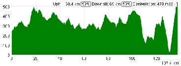
1/ Wednesday 6 February 2013 - Limoux > Gruissan - 146.5 km
The first stage of the Tour Med 2013 will start on the Esplanade François Mitterrand in Limoux and go southwards until Couiza before it turns east towards the two climbs of the stage which are both in the first 50 kilometers: first the Col du Paradis, followed by the Col des Fourches.The trip continues north-east, via the sprint in Talairan and the feeding zone and will than turn around Narbonne, first on the west side, than north and finally going back south on the east side of the city.
The riders will follow the coast line down to Gruissan where they will cross the finish line for the first time, followed by a short loop around the city over 4.7 kilometers.
Hereunder you'll find the time- and route schedule, the profile and the race route on Google Maps for this stage. Click on each of the images to open them.


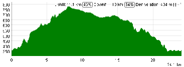
2/ Thursday 7 February 2013 - Cap d'Agde > Sète - Mont Saint-Clair - individual time trial - 24 km
This second stage of the Tour Med 2013 will see the individual time trial make its come back in the race. This stage will start off at the Avenue des Contrebandiers in Cap d'Agde and go via Marseillan-Plage down to Sète over an almost straight line race route.Each of the riders will than go to the east side of the city to get to the foot of the final climb, the Mont Saint-Clair, on top of which we'll know who's the winner of this individual effort.
Hereunder you'll find the time- and route schedule, the profile and the race route on Google Maps for this stage. Click on each of the images to open them.


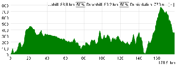
3/ Friday 8 February 2013 - Marseille (l'Estaque) > Saint-Rémy-de-Provence - 159 km
After a transfer of almost 200 kilometers, the riders who form the peloton of the 40th edition of the Tour Med will meet again on the Plage de l'Estaque in Marseille.After a visit of Marignane, they'll go towards Aix-en-Provence but before they get there, they'll turn north-west towards Coudoux and Lambesc and the climb of the Côte de Lambesc.
A sinuous descent to Charleval later, they'll turn west towards the feeding zone in Eyguières. When they get to Maussane-les-Alpilles they'll go towards Saint-Rémy-de-Provence but before they get there they turn left to climb up to Les Baux-de-Provence. This will all be followed by three laps of this loop via this climb and the finish line on Place Mireille before one of them can finally raise his hands for victory in this 3rd stage.
Hereunder you'll find the time- and route schedule, the profile and the race route on Google Maps for this stage. Click on each of the images to open them.


4/ Saturday 9 February 2013 - Rousset > Toulon - Mont Faron - 145 km
This stage will be a bit hilly from start till end but there won't be any big climbs until ... the final part!Indeed, this is the famous stage with the Mont Faron in Toulon which often has had an important role to play in the history of the Tour Med. Will this climb once again deliver the overall winner of the race, like last year when Jonathan Tiernan-Locke showed off his perfect shape at the start of the season? In contrast to last year, there will still be one stage after this finish, but chances are that some small time gaps will already be visible in the general classification after this stage.
Hereunder you'll find the time- and route schedule, the profile and the race route on Google Maps for this stage. Click on each of the images to open them.


CONTINUE READING AFTER THIS ADVERTISEMENT
5/ Sunday 10 February 2013 - Bandol > Grasse - 192 km
The Tour Med 2013 will finish with the longest stage in this race, 192 kilometers between Bandol and Grasse.From the Harbour of Bandol, the peloton first does part of the race route of yesterday's stage and will than turn north-east, via Draguignan and the climbs of Les Tuillières and of the Col du Tanneron.
From there, the riders will go north towards the finish in Grasse where they'll do a final loop of 24 kilometers around the stage finish city. At the second crossing of the finish line we will than not only know the name of the stage winner but also the overall winner of the Tour Med 2013 !
Hereunder you'll find the time- and route schedule, the profile and the race route on Google Maps for this stage. Click on each of the images to open them.
There seems to be a problem in the generation of the profile for this stage. It seems to be that the final loop is not taken into account :-(. Therefore, you find a separate image for the profile of the final loop.


The Tour Méditerranéen 2013 race route in Google Earth
You have just discovered all details of the different stages of this 40th Tour Med with the time- and route schedules, the stage profiles and for each of them a Google Maps version of the race route.If you'd like to see the full race route of the Tour Med 2013 in one view, you can download the KML file below and open it in Google Earth.
>> Download the Tour Med 2013 race route in Google Earth

Since the information provided by the organisor of the race doesn't contain much details, I cannot guarantee the exact locations of fictive and real starts, nor the way the riders will follow in between. The other elements most logically correspond quite well to the exact race route, even though when crossing cities and towns, the roads the riders will follow might vary a bit. Therefore, if you use this information to go see the race, don't forget to ask locally to make sure you're at the right place! :-) door Thomas Vergouwen
Vond u dit artikel interessant? Laat het uw vrienden op Facebook weten door op de buttons hieronder te klikken!
6 comments | 12461 views
this publication is published in: Tour Med | OpenStreetMap/Google Maps/Google Earth


 by marco1988 over
Merci pour l'article, mais il me semble que le profil de l'étape 5 ne colle pas avec la distance, où se situerait le problème ? En tout cas un parcours très intéressant même si le CLM est un peu trop long à mon goût (15kms auraient été parfaits...).
Bonjour veji1,
Effectivement, il semble y avoir une différence entre distance annoncée pour cette étape et ce qui sort sur le profil généré automatiquement à partir du fichier KML.
Après analyse, le fichier KML fait bien la distance correcte, c'est le profil qui ne semble pas prendre en compte la boucle locale autour de la ville d'arrivée. J'ai donc rajouté une image spécifique pour le profil de la boucle locale.
l'étape du vendredi 8 a été annulé ar le préfet des bouches du rhone
Tout à fait, comme signalé sur la fiche de la course dans calendrier cycliste UCI interactif depuis le début de la soirée :-).
comment ce fait il que tls le soir sur france3 ne donne aucun commentaire sur votre trés belle épreuve française, le quatar et la nba sont proritaires quelle
déception , bravo d'organiser encore de trés belles courses comme la votre dans
notre pays. VIVE LE VELO
bonjour
y a t'il une caravane comme dans le tour de france??