This Friday, 5 May 2017, the Tour of Italy 2017 (or Giro d'Italia 2017) will start on the island Sardinia south of Corsica, with three stages in line on the island followed by a transfer towards the mainland. All the other details about the race route, the roads the riders will follow, the time- and route schedules, the stage profiles and the race route on Google Maps/Google Earth can be discovered in this article, so you can follow the battle for pink with all the knowledge of the race you need!
Due to a lack of time and since the conception of these maps requires quite a lot of work, velowire.com offers you to start with the race route of the 9 first stages, knowing that the following stages will be published progressively as soon as I finish them, but in any case always quite some time before they'll take place! The KMZ file which allows you to view these maps in Google Earth is now also available will be provided as soon as all stages have been published.
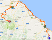
The Giro d'Italia 2017 race route on Google Maps
In total, 3,609.1 kilometers will be on the programme of the race, of which 69.1 kilometers as individual time trials (the tenth stage the day after the second rest day, of 39.8 kilometers, and the 21ste and last stage, of 29.3 kilometers): 3 stages on Sardinia and all the other stages in Italy, without visiting a foreign country for this 100th edition of the Giro d'Italia. Besides the time trials, the stages can be split into 6 plain stages, 8 middle mountain stages and 5 mountain stages. 4 stages will have an uphill finish (two of which are middle mountain stages and two of which mountain stages).CONTINUE READING AFTER THIS ADVERTISEMENT
1/ Friday 5 May 2017 - Alghero > Olbia - 206 km
The Giro d'Italia 2017 will thus start in Alghero at the north-west of the Sardinia island. Traditionnally the Giro d'Italia starts with a team time trial but this time it will be a stage in line and the first time trial will only be the tenth stage, knowing that there will be no single team time trial.For this 100th edition of the Tour of Italy this will be a stage of 206 kilometers which will mainly follow the coast on the northern and north-eastern side of the island, down to the city of Olbia. 3 climbs of the 4th category are part of this stage, Multeddu, Trinità d'Agultu and San Pantaleo.
Hereunder you can find the race route on Google Maps, the stage profile and the time- and route schedule (with the times at which the race visits the different cities and towns on the race route) of this stage of the Tour of Italy 2017. Click on the images to open them:


2/ Saturday 6 May 2017 - Olbia > Tortolì - 221 km
The 2nd stage of the Giro d'Italia 2017 will already be the first middle mountain stage of this 100th edition of the race and it will start in the city of Olbia at the north-east of Sardinia, in a street very close to the finish of the previous stage.During this stage, the riders will go down south, visiting the inland, first towards the sprint in Buddusò. Via the feeding zone, the riders will go on towards the first climb of the 3rd category of this 100th Tour of Italy, in Nuoro. They'll then continue towards the coast, for the sprint in Dorgali, before they start the climb of Genna Silana, first climb of the 2nd category and first point above 1000 meters altitude for the race.
We're quite close to the finish in Tortolì already at that time and they'll get to the finish via a short detour in order to arrive towards the long finish line coming from the east.
Hereunder you can find the race route on Google Maps, the stage profile and the time- and route schedule (with the times at which the race visits the different cities and towns on the race route) of this stage of the Tour of Italy 2017. Click on the images to open them:


3/ Sunday 7 May 2017 - Tortolì > Cagliari - 148 km
The next day, the 3rd stage will again be a flat stage, which starts in the finish city of the previous stage, Tortolì and which is only 148 kilometers long, towards Cagliari.The race route will lead the riders plain south to start with, via the intermediate sprint of Ponte su Santu and will then continue south-east down to Villasimius where they'll find the second intermediate sprint. Just after they continued the race route westwards, the riders will have to climb a 4th category hill, the Capo Boi. This climb should however not prevent the sprinters to battle for the victory in this last stage on the island, because the finish line will be at about fourty kilometers further, in Cagliari.
Hereunder you can find the race route on Google Maps, the stage profile and the time- and route schedule (with the times at which the race visits the different cities and towns on the race route) of this stage of the Tour of Italy 2017. Click on the images to open them:


R1/ Monday 8 May 2017 - rest day
After these three stages on Sardinia, a transfer towards the southern point of Italy will follow. Therefore, a first rest day is planned already this Monday 8 May and that's also why this Giro d'Italia 2017 starts on Friday 5 May instead of Saturday 6 May as it would usually have been the case!CONTINUE READING AFTER THIS ADVERTISEMENT
4/ Tuesday 9 May 2017 - Cefalù > Etna - 181 km
The first stage on the foot of Italy will start in Cefalù, in the south of Italy. This will be the first mountain stage because, after having followed the coastline till Sant'Agato di Militello, the riders will go on south-east going landinwards via the climb of the Portella Femmina Morta, a 2nd category climb.After the descent, the trip goes on on a hilly part, with the two intermediate sprints, in Bronte and in Biancavilla, but before they get to the finish line, the real climbers will again show off their forces, on the climb of the Etna.
Hereunder you can find the race route on Google Maps, the stage profile and the time- and route schedule (with the times at which the race visits the different cities and towns on the race route) of this stage of the Tour of Italy 2017. Click on the images to open them:


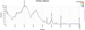
5/ Wednesday 10 May 2017 - Pedara > Messina - 159 km
The 5th stage will again offer a race route which is a bit easier for the riders of the Giro d'Italia 2017 and it will start at the foot of the Etna, in Pedara. As for the previous flat stage, this will again be a relatively short stage, of 159 kilometers, which first goes south towards Catania before going back up north landinwards, via the climb of Andronico-Sant'Alfio (4th category) and up to Francavilla di Sicillia, where the riders will turn right, towards the coast where they'll rapidly find the intermediate sprint in Taormina, followed just a bit further by the sprint in Roccalumera.Still following the coast line, the peloton of the Tour of Italy 2017 will continue on towards the finish city, but before they cross the finish line in the G. Garibaldi in Messina battling for victory, the sprinters teams will have to get organised on one short lap of a local circuit around the finish line.
Hereunder you can find the race route on Google Maps, the stage profile and the time- and route schedule (with the times at which the race visits the different cities and towns on the race route) of this stage of the Tour of Italy 2017. Click on the images to open them:


6/ Thursday 11 May 2017 - Reggio Calabria > Terme Luigiane - 217 km
From Messina, the whole Giro d'Italia 2017 caravan will take the boat to get to the start of the 6th stage, in Reggio Calabria. From Reggio Calabria the race follows the coast line going up north and when they go landinwards, the riders will get up a 3rd category climb in Barritteri before they find much further the intermediate sprint in Mileto and rapidly after that the sprint in Vibo Valentia. After the feeding zone they'll again follow the coastal road.There will be a short sidetrip landinwards however, at a few kilometers from the finish line, in order to allow the race to go find the 4th category climb in Fuscaldo. Instead of directly going to the finish in Terme Luigiane, the riders will have to continue up to Marina di Cetraro where they'll turn around on a parallel road in order to go on till the finish of this 6th stage.
Hereunder you can find the race route on Google Maps, the stage profile and the time- and route schedule (with the times at which the race visits the different cities and towns on the race route) of this stage of the Tour of Italy 2017. Click on the images to open them:


7/ Friday 12 May 2017 - Castrovillari > Alberobello (Valle d'Itria) - 224 km
After the start in Castrovillari and a short climb, this stage will start with a big descent and a flat part over the first 130 kilometers following the coast line from west to east at the bottom of the foot of Italy. After the sprint in Massafra the riders will start the climb of Bosco delle Pianelle of the 4th category, followed a bit further by the intermediate sprint in Martina Franca, at a few kilometers from the finish in Alberobello which the riders will cross after a short loop in the city.Hereunder you can find the race route on Google Maps, the stage profile and the time- and route schedule (with the times at which the race visits the different cities and towns on the race route) of this stage of the Tour of Italy 2017. Click on the images to open them:


CONTINUE READING AFTER THIS ADVERTISEMENT
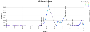
8/ Saturday 13 May 2017 - Molfetta > Peschichi - 189 km
The next day, the 8th stage will be a middle mountain stage which will start in Molfetta, for 189 kilometers.The 80 first kilometers will be completely flat following the coast line, up to the intermediate sprint in Manfredonia, followed just afterwards by the feeding zone. That's where the climbs which justify the qualification of this stage as a "middle mountain" stage will start, first with the Monte Sant'Angelo of the 2nd category, followed a bit further by the climb of the Coppa Santa Tecla, of the 4th category.
Continuning towards the finish in Peschichi, via the sprint in Vieste, the riders will realise that the road is not completely flat and even though the finish is not referenced as a uphill finish, it won't be completely flat either towards the finish line going up from the sea level towards the finish in the city center.
Hereunder you can find the race route on Google Maps, the stage profile and the time- and route schedule (with the times at which the race visits the different cities and towns on the race route) of this stage of the Tour of Italy 2017. Click on the images to open them:


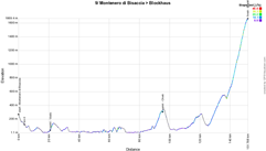
9/ Sunday 14 May 2017 - Montenero di Bisaccia > Blockhaus - 149 km
The day before the second rest day, another middle mountain stage is on the programme this Sunday 14 May, this time with a real uphill finish.After the start in Montenero di Bisaccia, the race will go off towards the coast and the intermediate sprint in Vasto and then follow the coast line up to Francavilla al Mare on almost completely flat roads. The riders will then climb towards the sprint in Chieti before they start a bit further on the final climb, 13.6 kilometers long with an average steepness of 8.4% but going up till 14%. Climbing up to 1665 meters altitude, the riders will battle for victory in Blockhaus.
Hereunder you can find the race route on Google Maps, the stage profile and the time- and route schedule (with the times at which the race visits the different cities and towns on the race route) of this stage of the Tour of Italy 2017. Click on the images to open them:

R2/ Monday 15 May 2017 - rest day
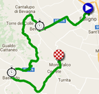
The second rest day of this Giro d'Italia 2017 will allow the riders to get some rest after this first week of racing, in Montefalco, after a transfer of about 260 kilometers from the finish of the 9th stage in Blockhaus, where the stage will finish the next day.10/ Tuesday 16 May 2017 - Sagrantino stage - Foligno > Montefalco - individual time trial - 39.8 km
After this rest day, the caravan of the Giro will get back together in Foligno for an individual time trial stage.It'll be a slightly hilly stage but without any real difficulties, over a distance of 39.8 kilometers. Even though the end of the stage is slightly uphill, this stage is pretty much made for a time trial specialist.
Hereunder you can find the race route on Google Maps, the stage profile and the time- and route schedule (with the times at which the race visits the different cities and towns on the race route) of this stage of the Tour of Italy 2017. Click on the images to open them:


CONTINUE READING AFTER THIS ADVERTISEMENT
11/ Wednesday 17 May 2017 - Firenze (Florence) > Bagno di Romagna - 161 km
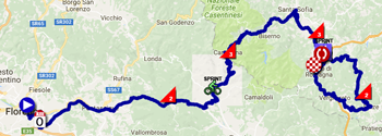
After this time trial, the 11th stage of the Giro d'Italia 2017 will be a middle mountains stage starting in Florence (Firenze in Italian) which does however show no less than 4 upfollowing difficulties. After about fifteen kilometers the riders will start with the climb of the first of these four, the Passo della Consuma of the 2nd category. After the sprint in Stia, the difficulties will continue with the climb of the Passo della Calla (3rd category) and a bit further they'll get on the Passo del Carnaio (3rd category).After the sprint in San Piero In Bagno and the feeding zone, the riders will get on a circuit which will bring them quite quickly to the finish line, before they'll continue south-east and starting getting back up north they'll climb the Monte Fumaiolo of the 2nd category, before they'll go back, this time for the stage victory, towards the finish line in Bagno di Romagna.
Hereunder you can find the race route on Google Maps, the stage profile and the time- and route schedule (with the times at which the race visits the different cities and towns on the race route) of this stage of the Tour of Italy 2017. Click on the images to open them:


12/ Thursday 18 May 2017 - Forlì > Reggio Emilia - 229 km
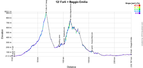
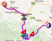
The 12th stage will start in Forlì, for a distance of 229 kilometers which will rapidly bring the riders landinwards, off to find the climbs of the Colla di Casaglia (2nd category) and of Valico Appenninico (3rd category), in-between which they'll find the feeding zone and the intermediate sprint in Barberino di Mugello. Close to Bologna, the riders will find the second intermediate sprint in Sasso Marconi and they'll continue on flat roads towards the finish in Reggio Emilia. If the finish of this stage will not be a bunch sprint, it'll have to be a strong rider which manages to stay ahead of the peloton to win this 12th stage!Hereunder you can find the race route on Google Maps, the stage profile and the time- and route schedule (with the times at which the race visits the different cities and towns on the race route) of this stage of the Tour of Italy 2017. Click on the images to open them:

13/ Friday 19 May 2017 - Reggio Emilia > Tortona - 167 km
The 13th stage of this Giro d'Italia 2017 will be a particularly flat stage starting in Reggio Emilia and the only moments which might be remarkable in this stage except from the finish in Tortona will be the two intermediate sprints in Fiorenzuola d'Arda and in Broni.Hereunder you can find the race route on Google Maps, the stage profile and the time- and route schedule (with the times at which the race visits the different cities and towns on the race route) of this stage of the Tour of Italy 2017. Click on the images to open them:


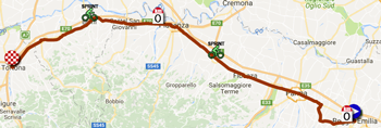
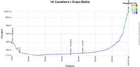
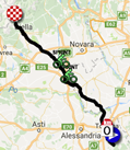
14/ Saturday 20 May 2017 - Castellania > Oropa - 131 km
The 14th stage will also be completely flat, starting in Castellania .. except for the 30 last kilometers! Indeed, that's where things can happen in this stage, in the final climb towards the sanctuary of Oropa!Before they get there, the riders will find the two intermediate sprints quite close to each other, in Caresana and in Vercelli.
Hereunder you can find the race route on Google Maps, the stage profile and the time- and route schedule (with the times at which the race visits the different cities and towns on the race route) of this stage of the Tour of Italy 2017. Click on the images to open them:

CONTINUE READING AFTER THIS ADVERTISEMENT
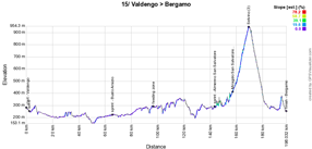
15/ Sunday 21 May 2017 - Valdengo > Bergamo - 199 km
The second day of this weekend will see another middle mountain stage awaiting the riders, starting in Valdengo, but this time the difficulty is again in the last 50 kilometers but not towards the finish in Bergamo. Indeed, after the intermediate sprint early in the stage in Busto Arsizio and just after the second intermediate sprint in Almenno San Salvatore, they'll find two difficulties which will follow up on each other, Miragolo San Salvatore (2nd category) and Selvino (3rd category) before the riders can continue on towards the finish, with however still a small climb in the higher part of the finish city, Bergamo.Hereunder you can find the race route on Google Maps, the stage profile and the time- and route schedule (with the times at which the race visits the different cities and towns on the race route) of this stage of the Tour of Italy 2017. Click on the images to open them:


R2/ Monday 22 May 2017 - rest day
After this heavy race weekend and week, the riders will again be able to get some rest, in Bergamo16/ Tuesday 23 May 2017 - Rovetta > Bormio - 222 km
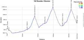
After this rest day, it won't be the race will continue with what will definitely not be seen as an easy stage since it contains, among other climbs, the climb towards the rooftop of this Tour of Italy 2017, the Passo dello Stelvio. Furthermore, this stage is not particularly short, 222 kilometers, starting in Rovetta. The 45 first kilometers will be flat till just after the intermediate sprint in Malonno where the riders start the climb of the first category Passo del Mortirolo. After its descent and early in the next climb, the riders wil find the feeding zone, after which the climb which brings them to the rooftop of the Tour of Italy get harder, the Passo dello Stelvio (Stilfserjoch). At the bottom of its descent they'll find the intermediate sprint, in Glorenza (Glurns), and immediately after it the riders will start the last climb of the day, the Umbrailpass (Giogo di Santa Maria). After the descent of this climb, they'll finally battle for the victory of this 16th stage, in Bormio.Hereunder you can find the race route on Google Maps, the stage profile and the time- and route schedule (with the times at which the race visits the different cities and towns on the race route) of this stage of the Tour of Italy 2017. Click on the images to open them:


17/ Wednesday 24 May 2017 - Tirano > Canazei - 219 km
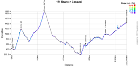
The next day, the stage will have almost the same distance but it'll be much easier, between Tirano and Canazei, with two 2nd category climbs early in the stage, the Aprica almost immediately after the start, followed by the climb of the Passo del Tonale. After the descent of this difficulty they'll find the intermediate sprint in Cles and the road will go on downhill down to the feeding zone after which there's another climb, of the 3rd category, which remains to be done, in Giovo. After the intermediate sprint in Cavalese it's slightly uphill that the riders will go on towards the finish in Canazei.Hereunder you can find the race route on Google Maps, the stage profile and the time- and route schedule (with the times at which the race visits the different cities and towns on the race route) of this stage of the Tour of Italy 2017. Click on the images to open them:


CONTINUE READING AFTER THIS ADVERTISEMENT
18/ Thursday 25 May 2017 - Moena > Ortisei/St. Ulrich - 137 km
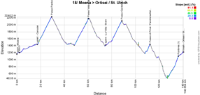
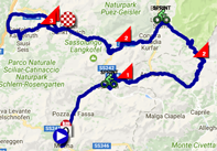
This Thursday a rather short stage will be on the programme starting in Moena (Val di Fassa). This stage, 137 kilometers long, will however be quite difficult with numerous climbs following up on each other! After about ten kilometers and the sprint in Canazei, it all starts with the 2nd category climb of the Passo Pordoi, rapidly followed by the Passo Valparola, also of the 2nd category. At the bottom of the latter one, the riders will find the second intermediate sprint, in La Villa/Stern, and rapidly after that they'll start the climb of the Passo Gardena (Grodnerjoch). Ater its descent there will be a smaller hill, of the 3rd category to be climbed, the Passo di Pinei (Panidersattel) but the difficulties are not over yet at that time because they still have the final climb to do towards Ortisei/St. Ulrich (Val Gardena) and in that climb they can get points for the King of the Mountains classification based on a 1st category climb, in Pontives.Hereunder you can find the race route on Google Maps, the stage profile and the time- and route schedule (with the times at which the race visits the different cities and towns on the race route) of this stage of the Tour of Italy 2017. Click on the images to open them:

19/ Friday 26 May 2017 - San Candido/Innichen > Piancavallo - 191 km
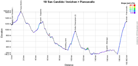
The stage of the last Friday of the Giro d'Italia 2017 will be a bit easier again, but it does end however with an uphill finish. The stage does start however with a 3rd category climb, the Passo Monte Croce Comelico (Kreuzbergpass), but the 80 following kilometers will be without much difficulties, with the sprint in Sappada and the feeding zone, just before the climb of the 2nd category Sella Chianzutan. After the descent it continues on flat roads, with the sprint in Maniago, up to 15.4 kilometers from the finish, where the final climb starts towards the finish in Piancavallo (1st category).Hereunder you can find the race route on Google Maps, the stage profile and the time- and route schedule (with the times at which the race visits the different cities and towns on the race route) of this stage of the Tour of Italy 2017. Click on the images to open them:


20/ Saturday 27 May 2017 - Pordenone > Asiago - 190 km
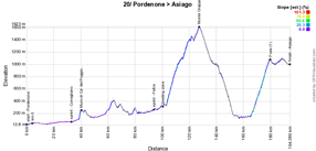
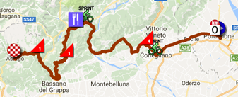
The next day, the forelast stage of the Giro d'Italia 2017 is on the programme, with a start in Pordenone, on flat roads until the sprint in Conegliano at kilometer 31. A bit further, the riders will climb a short but steep hill, the Muro di Ca' del Poggio (4th category). After a hilly part and the sprint in Feltre they'll go on with the 1st category climb of the Monte Grappa. Its descent will rapidly be followed by another 1st category climb, towards Foza. The riders will then stay at the level they've reached with this climb, continuing on to the finish in Asiago.Hereunder you can find the race route on Google Maps, the stage profile and the time- and route schedule (with the times at which the race visits the different cities and towns on the race route) of this stage of the Tour of Italy 2017. Click on the images to open them:

21/ Sunday 28 May 2017 - Monza (Autodromo Nazionale) > Milano - individual time trial - 29.3 km
The last stage of the Giro d'Italia 2017 will this year be an individual time trial, of a bit over 29 kilometers. Its route will be rather flat, or even slightly downhill, and this stage is thus made for a time trial specialist, like Tom Dumoulin (Team Sunweb) for example! Like the other riders, he will start on the auto track, the Autodromo Nazionale, in Monza, and he will end his race in front of the dome of Milan. Between those two locatios he will find, like the other riders of this Giro d'Italia 2017, a race route which alternates winding parts with straight roads directly going towards the finish city!Hereunder you can find the race route on Google Maps, the stage profile and the time- and route schedule (with the times at which the race visits the different cities and towns on the race route) of this stage of the Tour of Italy 2017. Click on the images to open them:


The Giro d'Italia 2017 race route in Google Earth
Do you prefer to see the race route of all the stages of the Tour of Italy 2017 at once? Or do you want to do a virtual fly-over of one or more of these stages? That's now possible by downloading the KMZ file (a ZIPped KML file, because of its huge size) and opening it in Google Earth that you'll find hereunder! WARNING - copyright: despite the fact that this KMZ file is provided for your personal use, please note that it's strictly forbidden to reproduce the contents of this KMZ file or any other element (including the maps, the profiles, the KML files and others) which make up the Tour of Italy 2017 race route. These contents are indeed protected by copyright and I thus ask you to respect the huge amount of time spent in creating them.
>> Download the complete Giro d'Italia 2017 race route in Google Earth (KMZ file, 344 kB)

Vond u dit artikel interessant? Laat het uw vrienden op Facebook weten door op de buttons hieronder te klikken!
3 comments | 30482 views
this publication is published in: Giro d Italia | OpenStreetMap/Google Maps/Google Earth | Giro d'Italia 2017


 by marco1988 over
Firstly a big thanks for what you've been doing for us for so long Thomas. My preference is for a Google Earth KML file for the whole race but understand if you need more people requesting a KML before putting the work in.
Hello @charlie,
Thanks for your feedback! As indicated in the article, it's not that I need people requesting me the Google Earth KML (or in this case KMZ) file in order for me to publish it, I just need to finish off all stages before I can publish it!
Working on it right now and I'll soon publish 6 additional stages, bringing the number of stages up to 15. Once the following stages will have been drawn as well, I'll be able to publish the file you can open in Google Earth as well :-)
Hello @charlie,
As promised, the Google Earth KMZ file is now available in the article above.