This Sunday, it's time for the only Dutch classic, the Amstel Gold Race. This will be the 58th edition since the first was held in 1966.
It will take place between the Markt in Maastricht and the Rijksweg in Vilt. Since 2013, the finish has no longer been at the summit of the Cauberg in Valkenburg, but at the same place as the finish of the 2012 World Championship races.
However, the course of the Amstel Gold Race 2024 is identical to that of last year, when it was modified, notably in its first part. This time, only the fictitious start has been moved closer to the real one, to the Markt (Market), but otherwise the course is strictly identical. It still features no fewer than 33 climbs, on this UCI WorldTour classified race (there has been some variation in this number of climbs over the years, with a minimum of 31 in 2010 and 2012 and a maximum of 35 in 2017 and subsequent years).
In this article you'll find the hourly itinerary and route of the Amstel Gold Race on an OpenStreetMap map (similar to Google Maps), and you can also download the route in Google Earth for a virtual flyover, for example.
CONTINUE READING AFTER THIS ADVERTISEMENT
The Amstel Gold Race 2024 course description
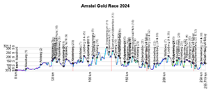
After the start at the Market (Markt) outside the center of Maastricht, the riders head north to Geulle and on to Elsloo, where they climb the Maasberg (1) and then to Urmond, before finally turning, this time in the direction of Sittard and heading south again to Beek. They then climb the Adsteeg (2). They then head up the Bergseweg (3) and continue on to discover other hills. These are Korenweg (4), Nijswillerweg (5) and then a climb up the Rijksweg N278 (6). The first part of the race on the map, drawn in yellow, ends at Cadier en Keer.On the second part of the route, drawn in blue, they first descend to the Belgian border, passing the Wolfsberg (7) and the Loorberg (8) before making a short foray north towards the town of Gulpen to get close to the Gulpenerberg, but without reaching its summit, We then descend to the south, climbing Schweibergerweg (9), before turning left and skirting the border again, climbing Camerig (10), forking off towards Vijlen and heading for Drielandenpunt (11) (a small peak where The Netherlands, Germany and Belgium meet). This is the blue section on the map, followed by the climb to Gemmenich (12) just over the Belgian border, and Epenerbaan/Vijlenerbos (13) after the return to the Netherlands. The riders are now in the orange section of the course, climbing the Eperheide (14), then heading north on the same route as the first leg, they change course to climb the Gulpenerberg (15), then the Plettenberg (16), Eyserweg (17), Sint Remigiusstraat (18), Vrakelberg (19), then the Sibbergrubbe (20) and Cauberg (21), before crossing the finish line for the first time.
The subsequent loop around the finish line, shown in green on the map, includes the ascent of Geulhemmerberg (22). After passing through Maastricht and back to Cadier en Keer, they then climb the Keederberg (23) before turning right at Bemelen to head for the Bemelerberg climb (24) and, after the Loorberg (25), they cut straight across before turning left to head for Gulperberg (26), after which they'll pick up Kruisberg (27) (instead of Plettenberg as on the first pass), then Eyserbosweg (28) and Fromberg (29). The peloton then turns left at Schin op Geul to reach the Keutenberg (30) before climbing back up to the second and final climb of the Cauberg (31), which this time will be followed by a final loop (in pink/purple) that resembles the 2012 World Championships circuit, with the climb of the Geulhemmerberg (32) in addition to the Bemelerberg (33). This time around, there'll be no more climbing the Cauberg!
The start will be given at 10:40am and the finish is scheduled for between 4:47pm and 4:56pm. The distance covered will be 253.6 kilometers.
Time schedule, race profile and route of the Amstel Gold Race 2024 on OpenStreetMap
Below you'll find the OpenStreetMap map (similar to Google Maps), the race profile and the timetable (with times of passage through the various towns and villages along the route) of the Amstel Gold Race 2024.To make the map easier to read, the route is displayed in five parts: the first in yellow, the second in blue, the third in orange and the fourth in green. The last loop, 21.3 kilometers long, is displayed in pink/purple.
IMPORTANT: to make it even easier for you to understand the sequence of the different parts of the route, you can display them one by one on the map. To do this, hover over the 3-layer icon in the top right-hand corner and choose the part(s) you wish to display by checking or unchecking them.


CONTINUE READING AFTER THIS ADVERTISEMENT
The Amstel Gold Race 2024 route in Google Earth
Would you prefer to view the Amstel Gold Race 2024 route in Google Earth, for example, and take a virtual flyover? Then download the KML file below:>> Download the Amstel Gold Race 2024 route in Google Earthdoor Thomas Vergouwen
Vond u dit artikel interessant? Laat het uw vrienden op Facebook weten door op de buttons hieronder te klikken!
no comments yet | 12735 views
this publication is published in: Classics | OpenStreetMap/Google Maps/Google Earth


 by marco1988 over