This Sunday, April 21, 2024 will see the 110th edition of Liège-Bastogne-Liège, which also answers to the name of La Doyenne. Despite the number of editions, you're still wondering why this nickname? When we tell you that the very first edition took place in 1892, more than 130 years before Liège-Bastogne-Liège 2024, you'll understand why we talk about this Monument in this way!
10 years ago, on the occasion of the 100th edition of the race, I published the history of Liège-Bastogne-Liège, so don't hesitate to read it again!
Last year, the route was slightly modified, with the famous côtes de la Redoute, des Forges and de la Roche-aux-Faucons still in the finale, but after climbing the Redoute, the riders found the new côte de Cornémont, which may not be listed for the côte prize, but it does spice up the finale a little more.
Once again this year, the route changes slightly for Liège-Bastogne-Liège 2024, but this time in the first part, before arriving in Bastogne.
In this article you'll find out about these changes, but also all the details of the Liège-Bastogne-Liège 2024 route with the course map on OpenStreetMap, which is also downloadable in Google Earth, the race profile and the hourly itinerary.
CONTINUE READING AFTER THIS ADVERTISEMENT
The Liège-Bastogne-Liège 2024 route on an OpenStreetMap map
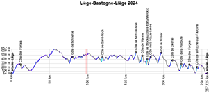
After the start from the Quai des Ardennes in Liège (where the finish will also take place) at 10.10 a.m. (the publicity caravan will set off at 8.40 a.m.!), the actual start will be given on the N30, 3 km from the assembly point, at around 10.15 a.m.Via Sougné-Rémouchamps and Aywaille, the race then descends first to the south, towards Manhay, where the route differs from last year. Instead of heading towards La Roche-en-Ardenne, the riders set off towards Baraque Fraiture, and then follow a slightly more easterly route than usual. The first difficulty, and the only one before starting the return journey from Bastogne, lies 76.2 kilometers from the start: this time it's not the Côte de La Roche-en-Ardenne, but the Côte de Bonnerue (2.5 km at 5.9%).
After passing the Rond-point La Doyenne in Bastogne (this roundabout is dedicated to La Doyenne throughout the year), back on the usual course, the riders then climb the Côte de Saint-Roch (1 km at 11.2%) and, much further on, the Côte de Mont-le-Soie, 93 km from the finish (1.7 km at 7.9%).
The riders then arrive at the famous triptych, which in the space of ten kilometers links Côte de Wanne (3.6 km at 5.1%), Côte de Stockeu (1 km at 12.5%), where they pass the Stèle Eddy Merckx (5 times winner of the event, including 3 consecutive times in 1971/1972/1973) and Côte de la Haute-Levée (2.2 km at 7.5%).
Fifteen kilometers further on, they find the usual Col du Rosier (4.4 km at 5.9%), then the Côte de Desnié (1.6 km at 8.1%) and the famous Côte de la Redoute with 34 km to go (2 km at 8.9%), the Côte des Forges (1.3 km at 7.8%) and the Côte de la Roche-aux-Faucons (1.3 km at 11%), the summit of which is 13.3 km from the finish. The finish will then be on the Quai des Ardennes in Liège, just like the start.
The finish is scheduled for between 4.10 and 4.46 pm.
Below you'll find the time- and route schedule and the route on an OpenStreetMap map, as well as the profile of Liège-Bastogne-Liège 2024. Click on the images to open them.


The Liège-Bastogne-Liège 2024 route in Google Earth
If you'd prefer to see the Liège-Bastogne-Liège 2024 route in Google Earth, for a virtual flyover for example, I invite you to download the race route in Google Earth by clicking on the following link:>> Download the Liège-Bastogne-Liège 2024 route in Google Earth (KML file)
CONTINUE READING AFTER THIS ADVERTISEMENT


 by marco1988 over