Today the 4 Jours de Dunkerque start in Dunkirk for 5 stages (during 5 days despite what the name might make you think) to bring back the pink jersey on the shoulders of the leader of the general classification to Dunkirk on Sunday.
As usual now for the different cycling races I now propose you to discover the 4 Jours de Dunkerque route on Google Maps kaart and in Google Earth together with the time and route schedules of this stage race in the north of France.
This 56st edition of the 4 Jours de Dunkerque which takes place from 5 till 9 May 2010 has 3 particularities:
- the race will be held over 5 days this year instead of the 6 days which had become usual until last year, due to budget reasons: according to the race's official website this is due to the fact that the Conseil Général of Pas de Calais is still not convinced of the interest of such an event on its territory ...
- for the first time in the history of the race, one stage will completely take place in Belgium, from Menen to Ieper with the climbs of the Monteberg, Kemmel and the Mont Rouge; this visit to the northern neighbours is also due to the abandon of the Conseil Général of Pas de Calais as a sponsor of the race
- on Saturday 8 May the riders will follow a unique circuit on the Mont Cassel which includes a total of over 20 kilometers of cobble stone zones
The 4 Jours de Dunkerque route on Google Maps
CONTINUE READING AFTER THIS ADVERTISEMENT
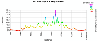
stage 1/ Dunkerque > Bray-Dunes (Les Dunes de Flandre) - Wednesday 5 May 2010 - 143.8 km
The first stage will of course start from Dunkirk. After the start from the Avenue de Rosendaël in front of the stadium, the first intermediate sprint is about 47 kilometers further, close to Wemaers-Cappel. The second intermediate sprint is just after Rexpoëde, while the line for the last intermediate sprint is drawn just before the finish in Bray-Dunes.The feeding zone is between Caestre and Fletre and the riders can take the first points for the Prix des Monts on top of the Mont des Cats.
Below you'll find the time- and route schedule, the stage profile and the route on Google Maps for this stage. Click on the images to open them.


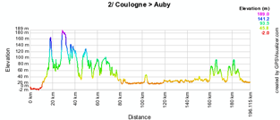
stage 2/ Coulogne > Auby - Thursday 6 May 2010 - 196.4 km
The second stage connects the Communauté d'Agglomération du Calaisis with the one of the Douaisis with a stage start at the Place de la Mairie in Coulogne and the stage finish on the Rue Jean Lebas in Auby. The stage has 3 intermediate sprints: the first on the Grande Rue in Thérouanne, the second in front of the city hall of Guarbecque and the last one in front of the church in La Bassée.The riders can get points for the Prix des Monts at 4 places: in Journy, in Estrée-Blanche and at the two crossings in Mons en Pevele.
The feeding zone is between Ham-en-Artois and Isbergues.
Below you'll find the time- and route schedule, the stage profile and the route on Google Maps for this stage. Click on the images to open them.


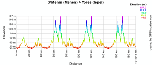
stage 3/ Menin (Menen) > Ypres (Ieper) - Friday 7 May 2010 - 189 km
The Friday stage will completely take place in Belgium, from Menen to Ieper. In addition to the intermediate sprints at the Parc Bellewaerde and two times in De Klijte, the riders will climb the Mont Kemmel three times.After having reached Ieper in a straight line from the start, the riders will first follow a short circuit, followed by 3 rounds on a bigger circuit around the Belgian city.
The feeding zone is in Ieper on the N8, just before the 3rd crossing of the finish line.
Below you'll find the time- and route schedule, the stage profile and the route on Google Maps for this stage. Click on the images to open them.


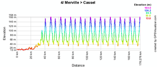
stage 4/ Merville > Cassel - Saturday 8 May 2010 - 181,3 km
The 4th stage is the traditional hilly stage, with the start from Merville and the finish in Cassel with a unique circuit including a total of 24 kilometers cobbled stones.After a short circuit around the start city, the riders will go straight to Cassel where they arrive on a 14.6 kilometer long circuit which includes an intermediate sprint in Oxelaere in the 3rd, 6th and 8th round and the climb of the Rue du Tambour and the Avenue Achille Samyn.
Below you'll find the time- and route schedule, the stage profile and the route on Google Maps for this stage. Click on the images to open them.


CONTINUE READING AFTER THIS ADVERTISEMENT
stage 5/ Ardres > Dunkerque - Sunday 9 May 2010 - 179,5 km
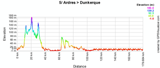
The last stage starts in Ardres with a loop including the climb of the Mont de Fiennes and the Vigneau de Licques. On their way to Dunkirk the riders will climb the Montagne de Watten and battle for the intermediate sprint in Coudekerque. Just after the feeding zone in Hoymille they will follow a 7 kilometer long circuit in the streets of Dunkirk for 10 final rounds.On this circuit they'll find two intermediate sprints on the Digue de Mer.
Below you'll find the time- and route schedule, the stage profile and the route on Google Maps for this stage. Click on the images to open them.


The 4 Jours de Dunkerque 2010 route in Google Earth
You have now discovered all details of the different stages of this 56st edition of the 4 Jours de Dunkerque, including the time- and route schedules, the stage profiles and the route on Google Maps for each of the stages.If you would like to see the full route of the 4 Jours de Dunkerque 2010, you can download the file below and open it in Google Earth.
> Download the 4 Jours de Dunkerque 2010 route in Google Earth
This file will not only allow you to see the full route in Google Earth, but also to do a virtual fly-over over the route of one or more of the stages. To do so, you can of course use the default settings of Google Earth, but if you want to do a fly-over which really gives you the idea you were on your bike riding on the roads of the 4 Jours de Dunkerque 2010, I recommend you the following settings: in the menu Tools > Options choose the tab Touring and fill in the following choices on that tab:
- Camera tilt angle : 80.0 degrees
- Camera range : 150.0 meters
- Speed : 500.0 (if this makes you feel dizzy or if your computer or Internet connection don't allow you to get clear images with these settings, you can try lowering the speed)
 WARNING: since the stage maps and the time- and route schedules provided by the organisation of the 4 Jours de Dunkerque are very hard to read, there might be - especially close to the start and finish - some small mistakes in the routes shown on Google Maps. Therefore, if you plan to visit one of the stages, I would recommend you to ask for the precise route locally. door Thomas Vergouwen
Vond u dit artikel interessant? Laat het uw vrienden op Facebook weten door op de buttons hieronder te klikken!
1 comment | 11619 views
this publication is published in: 4 Jours de Dunkerque | OpenStreetMap/Google Maps/Google Earth


 by marco1988 over
http://www.cyclisme-roltiss-over.com/article-le-parcours-des-4-jours-de-dunkerque-2010-sur-google-maps-google-earth-et-les-itineraires-horaires-49857310.html