After the Tour de France, August reserves 3 stage races for the riders in France: in the order on the calendar that's the Tour de l'Ain (10 to 14 August), the Tour du Limousin (17 to 20 August) and the Tour international Poitou-Charentes (24 to 27 August). Like last year I'll again work for the Tour du Limousin to prepare some interesting contents for the official web site of the race and that's why I can now allow you to discover, as a prime before the publication on the official website, the route of the Tour du Limousin 2010 on Google Maps and in Google Earth!
It has now become quite usual for me to publish the race route of different cycling races on Google Maps/Google Earth and the Tour du Limousin could of course not be missing on my ever growing list of races I drew on Google Maps in 2010.
In this article you'll find the route and time schedules, the stage profiles and for each of the 4 stages the route on Google Maps. At the end of the article you'll find a file which you can download and which will allow you to view the whole route of the Tour du Limousin 2010 in Google Earth and thus also do a virtual fly-over over one or more of the stages as if you were there!
The Tour du Limousin 2010 will take place from Tuesday 17 till Friday 20 August, in the Limousin region and with a short visit of the Cher department for an individual time trial in and around Saint-Amand-Montrond. The 43rd edition will offer a total of a bit more than 610 kilometers in its 4 stages.
The stages of the Tour du Limousin 2010
Below you can find a table with the 4 stages of the Tour du Limousin 2010. Click on each of the stages to read a short description of it, view the stage profile, the route map on Google Maps and the route and time schedules which will tell you at what time the race passes in each of the cities and villages visited by the 43rd edition of the Tour du Limousin.| # | type | date | start | finish | distance |
|---|---|---|---|---|---|
| 1 | in line | Tu. 17 August 2010 | Limoges | Boussac | 193.1 km |
| 2 | individual time trial | We. 18 August 2010 | Saint-Amand-Montrond | Saint-Amand-Montrond | 45.1 km |
| 3 | en ligne | je. 19 août 2010 | Uzerche | Mansac | 191,5 km |
| 4 | in line | Fr. 20 August 2010 | Ambazac | Limoges | 180.8 km |
The stage routes on Google Maps, stage profiles and the route and time schedules of the Tour du Limousin 2010 stages
CONTINUE READING AFTER THIS ADVERTISEMENT
01/ Tuesday 17 August 2010 : Limoges > Boussac - 193.1 km
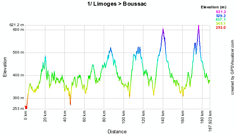
As usual, the first stage of the Tour du Limousin will start on the Champ de Juillet in Limoges. The end of the neutralisation will be 9.7 kilometers further on the D.220 in Beaune-les-Mines.This stage contains 3 difficulties: the Côte de Bessines (3rd categorie) at 5,1% of which the top will be placed after 41.4 kilometers, the Côte de Glénic (2nd categorie) at 4,34% and finally the Côte de Toulx Sainte Croix (2nd categorie) at 4,67% at 15.2 km from the finish in Boussac.
There will be 3 intermediate sprints for the classification by points: in Saint-Etienne-de-Fursac, in Guéret and at the first crossing of the finish line. The feeding zone of this stage will be exactly at mid-race, just before arriving in Saint Fiel.
The stage finish will be in the Rue du 11 novembre at the end of a final straight line of 350 flat meters.
Below you'll find the stage route and time schedule, its profile and the route on Google Maps. Click on each of the images to open them.


2/ Wednesday 18 August 2010 : individual time trial in Saint-Amand-Montrond - 45.1 km
This Wednesday 18 August 2010, the individual time trial will make its comeback in the Tour du Limousin after a long absence. Indeed, the last time trial in the Tour du Limousin was in 1993 and it took place in the streets of Limoges with Charly Mottet as its winner.This stage will make the Tour du Limousin leave its usual playfield because Saint-Amand-Montrond is in the Cher department.
The comeback of the individual time trial might have been the reason for Fabian Cancellara (Team Saxo Bank) to participate in the Tour du Limousin 2010. Indeed, next to Fränk Schleck of the same team and Bradley Wiggins of Team Sky, the Swiss rider who won the Tour of Flanders, Paris-Roubaix, the Grand Prix E3, the Tour of Oman, the prologue of the Tour of Switzerland and the prologue and individual time trial of the Tour de France this year is one of the major riders in this 43rd edition of the Tour du Limousin!
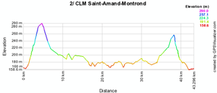
Will he also be the winner of this 45.1 km long individual time trial which starts in the Avenue des Carmes in Saint-Amand-Montrond and finish in the Rue Pelletier-Doisy after a loop through Arpheuilles followed by Le Pondy and Thaumiers (intermediate timing point) before getting back to Saint-Amand-Montrond via Verneuil and Meillant.
Below you'll find the stage route and time schedule, its profile and the route on Google Maps. Click on each of the images to open them.


CONTINUE READING AFTER THIS ADVERTISEMENT
3/ Thursday 19 August 2010 : Uzerche > Mansac - 191.5 km
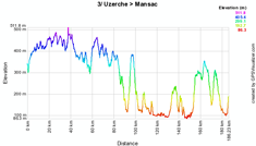
The 3rd stage of this 43rd edition of the Tour du Limousin will take place between Uzerche and Mansac over a distance of 191.5 kilometers.After the start in Uzerche, the riders will first do a loop north via Meilhards and the climb of the Côte de la Tour de Masseret (2nd category) at 7.9% before going back south to Lagraulière where the first intermediate sprint will take place and than towards Allassac before going slightly back north to get to the difficult Côte de Vertougit of the first category (6.6%) and going back south via Objat, the feeding zone in Saint-Viance and to the sprint close to Saint Pantaleon de Larche. After a first visit of Mansac they'll do a loop around the finish village including a sprint in La Rivière de Mansac followed by two 2nd category climbs: the Côte de Cublac (5.7%) and the Côte des Palinières (5.56%) at only 13.8 km from the finish line which will be at the town hall of Mansac.
Below you'll find the stage route and time schedule, its profile and the route on Google Maps. Click on each of the images to open them.


04/ Friday 20 August 2010: Ambazac > Limoges - 182.2 km
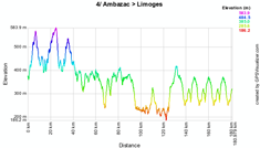
Before the traditional finish in Limoges with its circuit towards the finish line in front of the stadium on the Boulevard de Beaublanc, this stage follows after it start from Ambazac a circuit via Razès before turning east to the climb of the Côte de Jabreilles (3rd category) at 3.03% and Saint-Laurent-les-Eglises where the first intermediate sprint of this stage will take place.The stage than continues southwards with the climb of the Côte de Saint-Just-le-Martel (2nd category) at 5.52% and the sprint in Boisseuil. While going west, the riders will first find the feeding zone not far from this sprint before going north again towards Aixe-sur-Vienne and the circuit around Limoges via the Côte de Verneuil (2nd category) at 6.1%.
Below you'll find the stage route and time schedule, its profile and the route on Google Maps. Click on each of the images to open them.


The Tour du Limousin 2010 route, downloadable in Google Earth
 Above you have discovered the details of all stages of this 43rd Tour du Limousin including the time- and route schedules and the stage profiles and for each of them the route on Google Maps.
If you would like to see the complete parcours of the Tour du Limousin 2010, you can download the file below and open it in Google Earth.
>> Download the 2010 Tour du Limousin route in Google Earth
This file will not only allow you to see the full route in Google Earth, but also to do a virtual fly-over over the route of one or more of the stages. To do so, you can of course use the default settings of Google Earth, but if you want to do a fly-over which really gives you the idea you were on your bike riding on the roads of the 2010 Tour du Limousin, I recommend you the following settings: in the menu Tools > Options choose the tab Touring and fill in the following choices on that tab:
- Camera tilt angle : 80.0 degrees
- Camera range : 150.0 meters
- Speed : 500.0 (if this makes you feel dizzy or if your computer or Internet connection don't allow you to get clear images with these settings, you can try lowering the speed) door Thomas Vergouwen
Vond u dit artikel interessant? Laat het uw vrienden op Facebook weten door op de buttons hieronder te klikken!
3 comments | 8980 views
this publication is published in: Tour du Limousin | OpenStreetMap/Google Maps/Google Earth


 by marco1988 over
Merci beaucoup
Petite question:
comment peut-on mettre sur google earth des images?(ravitaillement,col/côtes,arrivée/départ etc....)
On risque de se croiser sur le long de la route. Je ne sais pas encore quelle(s) étape(s), je passe voir mais je te tiendrai au courant.
Un favori pour le classement final?
Beste Thomas, Alvast bedankt voor al je nuttige info, het blijft mijn belangstelling wegdragen en ik zie nu al uit naar de volgende berichten ivm de tour 2011. Graag vernam ik hoe men bv met groep brandt, carrefour e.a. de tour zou kunnen meemaken door elke dag in elke rit en vooral in de tijdspanne dat de tv beelden brengt mee zou kunnen werken aan het aanbrengen van de reklamedoeken, zoals ik dit jaar heb gezien op meerdere plaatsen, voral naar het einde van de ritten en op de cols. Hoe kan men zich aanmelden? Vriendelijk dank bij voorbaat voor uw ongetwijfeld nuttig antwoord. Beleefde groeten, marcel