After the Grand Prix Cycliste la Marseillaise which was won in a very beautiful way by Jérémy Roy, the very first stage race on the French cycling calendar is already about to start!
This race is the Etoile de Bessèges 2011 which will take place in 5 stages from Wednesday 2 until Sunday 6 February in the triangle Bessèges-Arles-Orange.
In this article you'll find the Etoile de Bessèges 2011 race route on Google Maps/Google Earth.
Since you might already get used to it and since I don't want to break with my habits to publish the race route of different cycling races on Google Maps/Google Earth, www.velowire.com now goes on with the race route of this stage race which was created in 1971. A race route which has elements to please several kind of riders ... who will follow up Samuel Dumoulin (Cofidis) for the final win?
CONTINUE READING AFTER THIS ADVERTISEMENT
1/ Wednesday 2 February 2011 - Beaucaire > Bellegarde - 153.1 km
The first stage will start on the Place Georges Clémenceau in Beaucaire for 110 kilometers towards the finish line in Bellegarde (which will be drawn in the Rue de la République). After having crossed the finish line, the riders will continue with 5 laps of a circuit around Bellegarde over a 7.8 kilometer distance for each of them.The first crossing of the finish line will already be at kilometer 49 after a first circuit south of the start and finish cities which visits Fourques and Saint-Gilles. The second loop is north of the two cities and visits Redessan, Jonquières-Saint-Vincent, Montfrin and Aramon before following the Rhône down back to the start city and continuing to the finish. The feeding zone will be just after Aramon.
One climb is on the programme of this first stage: the Côte de la Tour, close to Bellegarde.
Below you can find the profile and a map with the stage route of the first stage of the Etoile de Bessèges 2011.


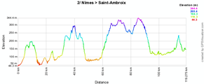
2/ Thursday 3 February 2011 - Nîmes > Saint-Ambroix - 149.4 km
The second stage will start from Nîmes where the start arch will be built up in the Avenue Bir-Hakeim. The stage will go northwards, towards the first climb of the day, a 2nd category hill just north of Saint-Laurent-la-Vernède. In Saint-André-de-Roquepertuis, the riders will continue eastwards towards the second climb of the day in Méjanes-le-Clap.A zig-zag route with the feeding zone just after Lussan will lead the riders to the finish line on the Boulevard du Portalet in Saint-Ambroix from which the riders will do 6 laps of a 7.3 kilometer long circuit around the finish city.


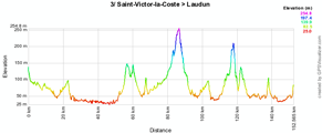
3/ Friday 4 February 2011 - Grand Prix du C.C. Rhône-Cèze-Languedoc - Saint-Victor-la-Coste > Laudun - 152.5 km
As you can see below, the 3rd stage's race route is quite complicated.The start will be on the Place de la Mairie in Saint-Victor-la-Coste where the riders will get back after a first 54 kilometer long loop via Bagnoles-sur-Cèze, Vénéjan and Caderousse.
They'll continue towards the finish line in the Rue Henri Dunant in Laudun-l'Ardoise. After having climbed the Mur de Laudun, the second climb of the day will be the Côte de Sabran which is followed by another loop which goes further north via Pont-Saint-Esprit and Carsan before going back to Laudun. The last loop will be the shortest since the riders will cross the finish line for the last time 14 kilometers further.


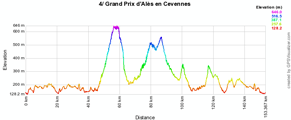
4/ Saturday 5 February 2011 - Grand Prix de la ville d'Alès - 152.4 km
This forelast stage will be done on a circuit around Alès. The first loop visits Brouzet-lès-Alès, Les Vieilles Fumades and Le Saut du Loup before passing west of Alès with the climb of the only first category hill of the Etoile de Bessèges 2011, the Col de la Barraque.Once they've passed close to La Grand-Combe, the riders can get some refreshments in the feeding zone in Les Tavernoles before they start the climb of the Col des Brousses followed by the Côte de Courry. In the Boulevard du Portalet in Saint-Ambroix, they'll sprint for some bonus seconds before they get back to Alès and the finish line on the Quai Boissier de Sauvages.


CONTINUE READING AFTER THIS ADVERTISEMENT
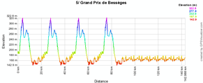
5/ Sunday 6 February 2011 - Gagnières > Bessèges - 145 km
The stage route of this last stage of the Etoile de Bessèges will start in Gagnières (the start arch will be built up in front of the Mairie) and the riders will immediately start the climb of the beautiful Côte du Châtaignier at the start of a 24.5 kilometer long loop which they'll do 3 times.The 4th time they will not get back to Gagnières since, after the feeding zone in La Croisée, they'll continue directly to the finish line in the Avenue Alphonse Peyric in Bessèges. From there, they'll do 7 laps on a 7 kilometer long circuit around the finish city to reach a total distance of 145 kilometers.


The Etoile de Bessèges 2011 race route in Google Earth
Would you like to visualise the race route of all stages of the Etoile de Bessèges 2011 in Google Earth? Click on the link below (after having installed Google Earth if necessary) to do so:> Download the Etoile de Bessèges 2011 race route in Google Earth

This file will not only allow you to view the complete race route in Google Earth but also to do a virtual fly-over of one or more of the stages. door Thomas Vergouwen
Vond u dit artikel interessant? Laat het uw vrienden op Facebook weten door op de buttons hieronder te klikken!
no comments yet | 9522 views
this publication is published in: Etoile de Bessèges | OpenStreetMap/Google Maps/Google Earth


 by marco1988 over