As usual, velowire.com allows you to discover all the details of the race route of this 102nd edition of the Grande Boucle, on Google Maps/Google Earth, at only a few days from the start of the Tour de France 2015.
With the informations in this article you'll get to know all small details, all cities and all towns visited by this Tour and this will allow you to prepare your visit to the race or simply help you to better understand it!
Some preliminary information ...
Some of you might have already discovered a Google Maps version of the race route maps published by the organisor of the Tour de France on the official website of the race.velowire.com could thus have simply sent you over to that website or take over the maps published on letour.fr. However, when you look a little bit closer, you'll quickly find out that these maps are not as detailed as you're used to find them here (the tracks pretty badly follow the roads) and that there are some mistakes in the track at several locations. Furthermore, this would not allow you to discover the race route in Google Earth and thus for example do a virtual fly-over of one of the stages of the Tour de France 2015.
That's why you'll find in this article, as usual for numerous cycling races, all the information about the race route of the 102nd Tour, the routes drawn on Google Maps, the time- and route schedules and the stage profiles, together with detailed informations about the main cities which are visited (or circumvented) by the race, the departments the race goes through, the climbs and mountains, the sprints, the roads the riders will follow between fictive start and the km 0 and all other useful informations to better understand the race route of this Tour de France with a Dutch/Belgian/French accent!
A little heads up before we discover the details of all the stages of the Tour de France 2015:
- as for any contents on velowire.com, its reproduction in any form is forbidden, as indicated in the copyright page. Please respect the important amount of time spent on preparing these contents!
- the stage profiles have been generated automatically based on the altitude informations known for the place where the race comes by; there might thus be some small hickups, but the global profile corresponds to the reality!
- at the time these maps have been prepared, the Tour de France 2015 roadbook was not yet made available to the press; therefore, there might be some small mistakes in the track followed between the fictive start and the km 0 for some stages, even though I tried to draw the map the best I could!
The programme of the Grand Départ of the Tour de France 2015
 Here are the dates for this Grand Départ of the Tour de France 2015:
- Wednesday 1st of July 2015: opening of the permanence and the press room at the Parc des Expositions Jaarbeurs Utrecht
- Thursday 2 July 2015: team presentation of the Tour de France 2015 in the Park Lepelenburg
- Saturday 4 July 2015: first stage of the Tour de France 2015 ridden as an individual time trial in Utrecht, over 13.8 km
- Sunday 5 July 2015: second stage of the Tour de France 2015 between Utrecht and Neeltje Jans in Zealand over 166 km
The race route of the Tour de France 2015 on Google Maps
Let's now discover all the details of the Tour de France 2015 race route, stage by stage:CONTINUE READING AFTER THIS ADVERTISEMENT
1/ Saturday 4 July 2015 - Utrecht (NL) > Utrecht (NL) - individual time trial - 13.8 km
The first stage of the Tour de France 2015 will take place as an individual time trial, the only one for the whole race!This first stage will have a completely flat race route of 13.8 km starting at the start ramp in front of the Jaarbeurs Utrecht, in the Truus van Lierlaan. The riders will immediately turn left on the Overste den Oudenlaan and at the roundabout (which they take on the outside to keep the lane free on the other side for the riders on the way back to the finish) they'll turn left on the Koningin Wilhelminalaan / Balijelaan. On the Vondellaan they'll turn right to cross the canal and get on the Briljantlaan. They'll again turn right to go off to the Venuslaan and the Rubenslaan towards the Herculeslaan where they pass in front of the Galgenwaard stadium, the stadium of FC Utrecht.
Via the Weg tot de Wetenschap (Route towards the Science) they'll then go on until the entrance of the Utrecht Science Park before they go back off west via the Archimedeslaan. They'll do a left-right-left via the Pythagoraslaan, Waterlinieweg and Biltstraat before they get to the canal via the Kruisstraat and then follow the Maliesingel. The riders will probably not have the time to pay attention to it but they'll go by the Maliebaan which is somehow the very first cycling lane of The Netherlands since the footpath was opened to cyclists on Sundays from September 1885!
They'll continue to follow the canals to get back on the Vondellaan and they'll then take the Balijelaan and Koningin Wilhelminalaan in opposite direction before they get on the roundabout which they'll now take from the other side before they turn right on the Doctor M.A. Teilegenlaan / Van Zijstweg. A last turn left brings them to the Croeselaan where the finish line will be drawn close to the Utrecht train station where a bike parking for up to 12,500 bikes will open in 2016.
You can find find a filmed version of the race route of this stage on velowire.com!
Hereunder you'll find the time- and route schedule, the profile and the Google Maps version of the race route of this stage. Click on the images to open them.


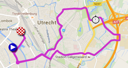
- start: the start ramp will be installed in the Truus van Lierlaan in front of the Jaarbeurs
- difficulties/climbs : none
- feeding zone : not applicable
- intermediate sprint : not applicable
- finish : Croeselaan just after the crossing with the Mineurslaan
- visited departments : Province of Utrecht from km 0 till km 13.8
- main cities : Utrecht
2/ Sunday 5 July 2015 - Utrecht > Neeltje Jans (Zealand) - 166 km
The second stage of the Tour de France 2015 will also start in Utrecht, but this time it'll be a stage in line, of 166 kilometers, towards the platform of Neeltje Jans in the province of Zealand.After a visit of the roads of the center of Utrecht, after the official start ceremony on the Stadhuisbrug - in front of the town hall - and a visit under the Dome, the race really leaves the city of the Grand Départ on the south-west side, on the N228. When the riders pass Gouda, they go off towards Rotterdam where they'll find the intermediate sprint of this stage.
Via Spijkenisse, Hellevoetsluis and Ouddorp they'll get to the province of Zealand which is formed by several peninsula. When they'll have crossed Schouwen-Duiveland, they get on the Brouwersdam dike and finally to the finish at Neeltje Jans, an artifical island in the dike which allows to protect the country from the sea at the eastern Scheldt entrance (Oosterschelde; the dike is called Oosterscheldekering).
Completely open to the wind, the finish of this stage will force the sprinters who want to take the victory in this 2nd stage of the Tour de France 2015 to pay attention so they won't be surprised by a front or side wind!
Hereunder you'll find the time- and route schedule, the profile and the Google Maps version of the race route of this stage. Click on the images to open them.


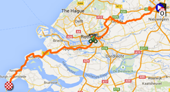
- start: in Utrecht, the start line will be drawn in the Croeselaan, close to the Jaarbeurs
- difficulties/climbs : none
- intermediate sprint : on the Boompjes in Rotterdam at km 80.5
- finish : at the entrance of the island / work platform of Neeltje Jans
- visited departments : Province of Utrecht from km 0 till km 35.5, Province of South-Holland (Zuid-Holland) from km 35.5 till km 144, Province of Zealand from km 144 till km 166
- main cities : Utrecht, Gouda, Rotterdam, Neeltje Jans
3/ Monday 6 July 2015 - Anvers (BE) > Huy (BE) - 159.5 km
The 3rd stage will be the last stage which will completely take place abroad and it'll start in Antwerp, at about 90 kilometers south-east of Neeltje Jans.The riders will go off south-east down to Havelange and then north towards the finish in Huy, on top of the famous Mur d'Huy (officially the chemin des Chapelles), known from the Flèche Wallonne which always finishes there. The last part of the stage contains several short climbs of which the Mur d'Huy will thus be the highlight!
Hereunder you'll find the time- and route schedule, the profile and the Google Maps version of the race route of this stage. Click on the images to open them.


- start: after the sign in on the Ernest van Dijckkaai, the fictive start will be at 1.10PM and the riders will follow the Jordaenskaai, Van Meterenkaai, Brouwersvliet, Hessenplein, Paardenmarkt, Italiëlei, Frankrijklei, Van Eycklei, Plantin en Moretuslei, Mercatorstraat, Cuperusstraat, Stanleystraat, Posthoflei, Posthofbrug, Arbeidersstraat, Edelgesteentenstraat, Diksmuidelaan, Gitschotellei, Drakenhoflaan, Borsbeeksesteenweg, de Robianostraat, Jozef Reusenslei, Lucien Hendirckxlei, Boechoutsesteenweg, Borsbeeksesteenweg and finally the N10 or Liersesteenweg where the km 0 will be found at 1.40PM
- difficulties/climbs : Côte de Bohissau (4, 2.4 km @ 5.5%) at km 109, Côte d'Ereffe (4, 2.1 km @ 5%), at km 143, Côte de Cherave (4, 1.3 km @ 8.1%), at km 154 and finally the finish on the Mur d'Huy (3, 1.3 km @ 9.6%), at km 159.5
- intermediate sprint : Havelange at km 128
- finish : Chemin des Chapelles / Mur d'Huy in Huy
- visited departments : Province of Antwerp from km 0 till km 15.5, Province of Flemish Brabant from km 15.5 till km 64.5, Province of Welsh Brabant from km 64.5 till km 72.5, Province of Liège from km 72.5 till km 91.5 and from km 96.5 till km 101 and from km 128 till km 159.5, Province of Namur from km 91.5 till km 96.5 and from km 101 till km 128
- main cities : Antwerp, Lier, Aarschot, Tienen, Havelange and Huy
4/ Tuesday 7 July 2015 - Seraing (BE) > Cambrai - 223.5 km
The 4th stage of the Tour de France 2015 is the first one which will enter France and it'll start in Seraing in Belgium, at about 25 kilometers north-east of Huy.After the start from Seraing, the riders will go back to Huy from where they'll continue towards Namur and its famous Côte de la Citadelle. After a short visit north in order to get around Charleroi, they'll continue south-west, via the sprint in Havay, at the border with France. After a first cobbled section in Belgium (from Pont-à-Celles to Gouy-lez-Piéton, over 1,800 m), the last 50 kilometers will contain no less than 6 cobbled sections with the last one ending at 13 kilometers from the finish in Cambrai:
- from Artres to Famars, over 1,200 m
- from Quérénaing to Verchain-Maugré, over 1,600 m
- from Verchain-Maugré to Saulzoir, over 1,200 m
- Saint-Python, over 1,500 m
- from Fontaine-au-Tertre to Quiévy, over 3,700 m
- from Avesnes-les-Aubert to Carnières, over 2,300 m
Hereunder you'll find the time- and route schedule, the profile and the Google Maps version of the race route of this stage. Click on the images to open them.


- start: the riders will start on the Chaussé d'Ivoz at noon and follow the N90 where they'll find the km 0 at 12.05PM
- difficulties/climbs : the Côte de la Citadelle de Namur at km 53 (4th category, ^ 181 m / 2 km @ 4.8 %)
- intermediate sprint : Havay
- finish : in the Rue Pasteur in Cambrai, in front of the town hall
- visited departments : Province of Liège from km 0 till km 26, Province of Namur from km 26 till km 79, Province of Hainaut from km 79 till km 81 and from km 85 till km 137, Province of Welsh Brabant from km 81 till km 85, Nord (59) from km 137 till km 223.5
- main cities : Seraing, Huy, Namur, (turning around Charleroi), Binche (known of the Binche-Chimay-Binche race), Cambrai
CONTINUE READING AFTER THIS ADVERTISEMENT
5/ Wednesday 8 July 2015 - Arras > Amiens - 189.5 km
For the 5th stage, the Tour de France 2015 goes back to Arras where a stage started in 2014 as well.This stage will commemorate the 100 years of the first World War (1914-1918), passing in front of several commemoration locations. It all starts with a detour north of the start city, to pass in front of the Nécropole nationale Notre-Dame-de-Lorette, under Lens, and then in front of the Mémorial canadien de Vimy, before the riders go off south towards Péronne, via the sprint in Rancourt, the Nécromole nationale de Rancourt and the Historial de la Grande Guerre in Péronne.
They'll then cut off in western direction till Herbécourt before they go back up north until Combles where they'll turn west again via the Mémorial national sud-africain du Bois Delville and the Mémorial franco-britannique de Thiepval. They'll then continue back down south until Lamotte-Warfusée where the trip continues west, via the Mémorial national australien. This time they're off towards the finish of the stage in Amiens, which will - most probably in a bunch sprint - take place close to the Pôle National Cirque et Arts de la Rue and the Cirque Jules Verne.
Hereunder you'll find the time- and route schedule, the profile and the Google Maps version of the race route of this stage. Click on the images to open them.


- start: the fictive start will be on the Boulevard du Général de Gaulle à Arras, close to the Commonwealth Memorial and the Avenue du Mémorial des Fusillés, at 12.45PM and the riders will then follow the Boulevard Vauban, Boulevard Carnot, Rue Saint-Marguerite, Rue Gambetta, Rue Désiré Delansorne, Rue Emile Legrelle, Rue des Balances, Rue de la Taillerie, the Grand'Place, Rue Sainte Croix, Rue du Marché au File, Rue Méaulens, Rue de l'Abbé Pierre, the Place de Tchecoslovaquie, the Voie Notre Dame de Lorette/Route de Lens (D264) and finally the Chaussée Brunehaut (D341) in Anzin-Saint-Aubin where they'll get to km 0 at 1.00PM
- finish : Mail Albert 1er in Amiens
- visited departments Pas-de-Calais (62) from km 0 till km 79 and till km 80, from km 127.5 till km 132.5, Somme (80) till km 80 and from km 83.5 till km 127.5 and from km 132.5 till km 189.5
- main cities : Arras, Neuville-Saint-Vaast, Péronne, Albert et Amiens
6/ Thursday 9 July 2015 - Abbeville > Le Havre - 191.5 km
The 6th stage starting in Abbeville will first go off towards Dieppe and then follow the coast line. As surprising as it can be, that's where the riders will find two 4th category climbs, the Côte de Dieppe and the Côte de Pourville-sur-Mer. After a visit to Fécamp, the riders will battle for the intermediate sprint in Saint-Léonard and after a short visit of the nice views of Etretat, they'll climb the Côte du Tilleul of the 4th category before they go on to the finish in Le Havre, slightly uphill.Hereunder you'll find the time- and route schedule, the profile and the Google Maps version of the race route of this stage. Click on the images to open them.


- start: the fictive start will be at 12.40PM in the Boulevard Vauban and the riders will follow the Rue Saint-Gilles, Rue du Maréchal Foch, Place Max Lejeune, Rue Saint-Vulfran, Rue Jean Jaurès, Boulevard Voltaire / D928, the Chaussée de Rouvroy / D925, Route des Polonais and the D22 where they'll get to km 0 at 12.55PM
- difficulties/climbs : three difficulties on the programme, the Côte de Dieppe of the 4th category at km 72 (^ 85 m / 1.8 km @ 4%), the Côte de Pourville-sur-Mer of the 4th category at km 77.5 (^ 97 m / 2 km @ 4.5%) and the Côte du Tilleul also of the 4th category at km 162 (^ 105 m / 1.6 km @ 5.6%)
- intermediate sprint : Saint-Léonard at km 145.5
- finish : Rue du 329ème Régiment Infanterie in Le Havre
- visited departments : Somme (80) from km 0 till km 20.5, Seine-Maritime (76) from km 20.5 till km 191.5
- main cities : Abbeville, Dieppe, St-Valéry-en-Caux, Fécamp, Etretat and Le Havre
7/ Friday 10 July 2015 - Livarot > Fougères - 190.5 km
At about 80 kilometers south of the finish in Le Havre the day before, the start of the 7th stage of the Tour de France 2015 will take place in Livarot under Lisieux. Quite rapidly, the riders start the first climb of the day, the Côte de Canapville of the 4th category.Via Vimoutiers they go on to the intermediate sprint in Argentan and then continue south-west towards the finish in Fougères.
Hereunder you'll find the time- and route schedule, the profile and the Google Maps version of the race route of this stage. Click on the images to open them.


- start: the fictive start of this stage will be at 12.40PM in the Rue Maréchal Foch in Livarot and the riders will already be on the D4 where they'll get to the km 0 at 12.50PM
- difficulties/climbs : only one climb, the Côte de Canapville of the 4th category at km 12.5 (^ 210 m / 1.9 km @ 4.7%)
- intermediate sprint : in Argentan at km 65.5
- finish : on the Boulevard des Déportés in Fougères
- visited departments : Calvados (14) from km 0 till km 7.5 and at km 12.5, Orne (61) from km 7.5 till km 12.5 and from km 12.5 till km 96, Mayenne (53) from km 96 till km 171.5, Ille-et-Vilaine (35) from km 171.5 till km 190.5
- main cities : Livarot, Vimoutiers, Argentan, Fougères
8/ Saturday 11 July 2015 - Rennes > Mûr de Bretagne - 181.5 km
The 8th stage will start from the center of Rennes and will go off north-west up to Bécherel and then continue towards St-Méen-le-Grand in south-western direction. From there, the riders will again go north-west via Plénée-Jugon, the Col du Mont Bel-Air (4th category) and Moncontour. Just after that, the riders will battle for the intermediate sprint in Gare de Moncontour before they go south towards Rohan.They'll almost do a U-turn there and go back up towards Mûr de Bretagne and its climb towards the finish line on top of the 3rd category climb.
Hereunder you'll find the time- and route schedule, the profile and the Google Maps version of the race route of this stage. Click on the images to open them.


- start: in Rennes the riders will do the fictive start on the Boulevard de la Liberté at 12.40PM and they'll follow the Rue Maréchal Joffre, Place de la République, Quai Lamennais, Pont de Bretagne, Mail François Mitterrand, Rue Vaneau, Rue de Brest, Avenue Sir Winston Churchill, Avenue Charles Tillon, Avenue du Bois Labbé, Avenue de Cucillé, Avenue André Mussat, Rue Gabriel Germain, Boulevard de la Robiquette, La Vizeule and the D637 in Montgermont where they'll get to km 0 at 1.00PM
- difficulties/climbs : in addition to the Col du Mont Bel-Air of the 4th category at km 99.5 (^ 336 m / 1.5 km @ 5.7%), the riders will have to climb towards the finish line in Mûr de Bretagne on a 3rd category climb at km 181.5 (^ 293 m / 2 km @ 6.9%)
- intermediate sprint : in Gare de Moncontour at km 108.5
- finish : on top of the climb of Mûr de Bretagne (D767 / Prairie de Kersuard)
- visited departments : Ille-et-Vilaine (35) from km 0 till km 54, Côtes-d'Armor (22) from km 54 till km 143.5 and from km 166.5 till km 181.5, Morbihan (56) from km 143.5 till km 166.5
- main cities : Rennes, Bécherel, Saint-Méen-le-Grand, Plénée-Jugon, Collinée, Moncontour, Loudéac, Rohan, Mûr de Bretagne
CONTINUE READING AFTER THIS ADVERTISEMENT
9/ Sunday 12 July 2015 - Vannes > Plumelec - team time trial - 28 km
The 9th stage of the Tour de France 2015 surprised many people when the race route of this Tour has been officially announced. Indeed, this stage will be a team time trial while the UCI rules say that those kind of stages will have to take place in the first third (thus in the 7 first stages) of a Grand Tour. A.S.O. apparently managed to obtain a derogation, but depending on what happens during the previous stages, some teams might be unhappy with it because some riders might have already been eliminated during the previous stages, with the cobble stones for example, and that might weaken some of the teams!Starting in Vannes all the teams will have 28 kilometers to ride for this race against the clock (there will be two intermediate timing points, in Lesnevé at km 10 and in Le Croiseau (Plaudren) at km 20.5) knowing that the teams will have to climb the Côte de Cadoudal before they cross the finish line in Plumelec.
Hereunder you'll find the time- and route schedule, the profile and the Google Maps version of the race route of this stage. Click on the images to open them.


- start: the start ramp of this stage will be placed on the Place de la Libération in Vannes and the teams will start between 3.00PM and 4.45PM (which will have the 22 teams start every 4'45" (?)
- difficulties/climbs : even though it doesn't count for the climbers classification since it's a team time trial, the stage ends on the Côte de Cadoudal (^ 153 m / 1.7 km @ 6.2%)
- finish : Côte de Cadoudal in Plumelec (Route de Cadoudal)
- visited departments : Morbihan (56) from km 0 till km 28
- main cities : Vannes, Plumelec
R1/ Monday 13 July 2015 - rest day in Pau
While the riders will have taken a plane to get to Pau and enjoy the first rest day of this Tour de France 2015, the followers of the Tour will drive the big number of kilometers this day.When they're done with this transfer, they can assist to an event in the city of Pau. Indeed, as announced by the newspaper Sud Ouest, a memorial of the Tour de France will be presented at 5PM. Installed in the Bois-Louis, close to the Boulevard des Pyrénées, there will be 104 interactive totems, made of glass and aluminium, which represent each winner of the Tour de France since its creation in 1903 (101 totems), and two others in honour of the riders who died in the two World Wars and one introduction totem. They'll be painted in yellow, as you can see in the video below:
10/ Tuesday 14 July 2015 - Tarbes > La Pierre-Saint-Martin - 167 km
The day after the first rest day will be the first mountain stage of this Tour de France 2015. Indeed, even though the stage starts off easily after the start in Tarbes with just three 4rd category climbs in the first 150 kilometers, the riders will attack the final climb towards the first ever finish on top of La Pierre-Saint-Martin, just afterwards, and that'll be a hors category climb!After the start in Tarbes, the race goes off north-west via Morlaàs and via the Côte de Bougarber before continuing south-west via Mourenx, the Côte de Vielleségure, Navarrenx, Mauléon-Licharre, Tardets-Sorholus and the Côte de Montory. Straight south towards the Spanish border and, more importantly, the final climb of La Pierre-Saint-Martin.
Hereunder you'll find the time- and route schedule, the profile and the Google Maps version of the race route of this stage. Click on the images to open them.

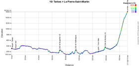
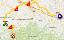
- start: the fictive start will be at 12.25PM in the Rue François Mousis in Tarbes and the riders will follow the Rue Maréchal Foch, Place de Verdun, Rue Georges Lassalle, Avenue Bertrand Barere, Avenue Maréchal Joffre / D935B, Avenue Marcel Billières, Rue Jean Mermoz / D935A, Rue Pierre Semard / D7, D2 in Bordères-sur-l'Echez where they'll get to km 0 at 12.35PM
- difficulties/climbs : Côte de Bougarber of the 4th category at km 66 (^ 257 m / 1.4 km @ 6.2%), Côte de Vielleségure of the 4th category at km 90 (^ 255 m / 1.7 km @ 5.9%), Côte de Montory of the 4th category at km 134 (^ 374 m / 1.8 km @ 6.3%) and the final climb towards La Pierre-Saint-Martin, hors category, at km 167 (^ 1,610 m / 15.3 km @ 7.4%)
- intermediate sprint : in Trois-Villes at km 124
- finish : on top of La Pierre-Saint-Martin, after a climb of 15.3 km @ 7.4%
- visited departments : Hautes-Pyrénées (65) from km 0 till km 4.5 and from km 13 till km 16.5, Pyrénées-Atlantiques (64) from km 4.5 till km 13 and from km 16.5 till km 167
- main cities : Tarbes, Morlaàs, Sauvagnon, Navarrenx, Mauléon-Licharre, Tardets-Sorholus, Arette, La Pierre-Saint-Martin
11/ Wednesday 15 July 2015 - Pau > Cauterets - 188 km
While the start location of this 11th stage is, as usual in Pau, in front of the Palais Beaumont, the track in the city of Pau will be a little bit more complicated than previous years. The km 0 will however be far so that won't be a problem for the riders who'd like to get a good place in this mountain stage or take back some seconds or even minutes for the general classification!The first half of the stage will only contain three climbs, respectively of the 3rd, 4th and 3rd category (Côte de Loucrup, Côte de Bagnères-de-Bigorre and Côte de Mauvezin). In the second half of the stage things however get a bit more complicated, with the successive climbs of the Col d'Aspin (1st category), Col du Tourmalet (hors category) and the final climb towards Cauterets which is finally quite easy compared to the two previous climbs and thus registered as a 3rd category climb.
Hereunder you'll find the time- and route schedule, the profile and the Google Maps version of the race route of this stage. Click on the images to open them.

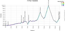
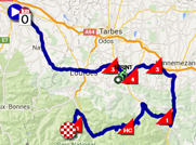
- start: the riders will start in Pau at 11.45AM in front of the Palais Beaumont in the Boulevard des Pyrénées, usual start location in this city. The riders will follow the Rue Adoue, Rue Henri IV, Rue Gassion, Rue Maréchal Joffre, Rue Serviez, Rue d'Orléans, Rue de Liège, Cours Camou, Allée du Grand Tour, Rue Bayard, Rue Marca, GELOS, Rue du 14 July, Avenue de Gelos / Rue Louis Barthou / Rue du Maréchal Leclerc / Avenue du Général de Gaulle / D37, D100, BIZANOS (close), D938 where they'll get to km 0 at 12.05PM
- difficulties/climbs : Côte de Loucrup of the 3rd category at km 48.5 (^ 530 m / 2 km @ 7%), Côte de Bagnères-de-Bigorre of the 4th category at km 61.5 (^ 644 m / 1.4 km @ 6.1%), Côte de Mauvezin of the 3rd category at km 74.5 (^ 501 m / 2.7 km @ 6%), Col d'Aspin of the 1st category at km 117 (^ 1,490 m / 12 km @ 6.5%), Col du Tourmalet, hors category, at km 147 (^ 2,115 m / 17.1 km @ 7.3%) where they'll find the Souvenir Jacques Goddet with the statue in honour of the former director of the Tour de France, and the final climb towards Cauterets of the 3rd category at km 188 (^ 916 m / 6.4 km @ 5%)
- intermediate sprint : in Pouzac at km 56.5
- finish : Place de la Gare in Cauterets
- visited departments : Pyrénées-Atlantiques (64) from km 0 till km 20.5, Hautes-Pyrénées (65) from km 20.5 till km 188
- main cities : Pau, Saint-Pé-de-Bigorre, Lourdes, Bagnères-de-Bigorre, La Barthe-de-Neste, Arreau, Barèges, Luz-St-Sauveur, Pierrefitte-Nestalas, Cauterets
CONTINUE READING AFTER THIS ADVERTISEMENT
12/ Thursday 16 July 2015 - Lannemezan > Plateau de Beille - 195 km
Another mountain stage will await the riders at the start in Lannemezan. Explorant the Pyrenees from west to east after the intermediate sprint in Saint-Bertrand-de-Comminges, they'll have 4 climbs to do. They'll start with the Col de Portet-d'Aspet of the 2nd category and will go on to the climb of the Col de la Core (1st category). A bit further, they'll find another first category climb, the Port de Lers and finally the climb towards the finish at the Plateau de Beille (hors category).Hereunder you'll find the time- and route schedule, the profile and the Google Maps version of the race route of this stage. Click on the images to open them.

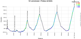
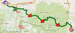
- start: after the sign in on the Place de la République, the fictive start will be at 11.10 in front of the Tonwn hall and the riders will follow the Rue Alsace-Lorraine (D939), the Route de Toulouse (D817), Rue Bellevue / D10 where they'll get to km 0 at 11.15AM
- difficulties/climbs : Col de Portet-d'Aspet of the 2nd category (^ 1,069 m / 4.3 km @ 9.7%), Col de la Core of the 1st category (^ 1,395 m / 14.1 km @ 5.7%), Port de Lers of the 1st category (^ 1,517 m / 12.9 km @ 6%) and the final climb towards Plateau de Beille, hors category (^ 1,780 m / 15.8 km @ 7.9%)
- intermediate sprint : in Saint-Bertrand-de-Comminges at km 20
- finish : at the Plate-forme n° 1 on the D522 on Plateau de Beille after a climb of 15.8 km
- visited departments : Hautes-Pyrénées (65) from km 0 till km 17, Haute-Garonne (31) from km 17 till km 59.5, Ariège (09) from km 59.5 till km 195
- main cities : Lannemezan, Sarp, Aspet, Les Bordes-sur-Lez, Le Port, Auzat, Ussat, Plateau de Beille
13/ Friday 17 July 2015 - Muret > Rodez - 198.5 km
In the outskirts of Toulouse, in Muret, the riders will start the 13th stage, towards Rodez.The first half of the stage, with the intermediate sprint in Laboutarie and crossing the Haute-Garonne and Tarn departments, is quite flat but the second half contains 3 small climbs: the Côte de Saint-Cirgue (3rd category), the Côte de la Pomparie (4th category) and the Côte de la Selve (4th category). After these climbs, straight north towards the finish line in Rodez.
Hereunder you'll find the time- and route schedule, the profile and the Google Maps version of the race route of this stage. Click on the images to open them.


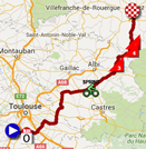
- start: after the sign-in at the Parc Jean Jaurès, the fictive start will be give at 12.20PM at the exit of the Pont de la Louge and the riders will go off for a long neutralised part, via the Allée Niel / Route d'Eaunes / D12, Avenue Roger Tissandié / Route de Labarthe / Avenue du Comminges / Avenue du Lauragais / D19, LABARTHE-SUR-LEZE, VERNET, VENERQUE, D35, D74 where they'll get to the km 0 at 12.40PM
- difficulties/climbs : Côte de Saint-Cirgue of the 3rd category at km 131 (^ 422 m / 3.8 km @ 5.8%), Côte de la Pomparie of the 4th category at km 156.5 (^ 578 m / 2.8 km @ 5%) and the Côte de la Selve of the 4th category (^ 661 m / 3.9 km @ 3.7%)
- intermediate sprint : in Laboutarie at km 92.5
- finish : Avenue de Saint-Pierre in Rodez
- visited departments : Haute-Garonne (31) from km 0 till km 44, Tarn (81) from km 44 till km 142, Aveyron (12) from km 142 till km 198.5
- main cities : Muret, Lavaur, Graulhet, Rodez
14/ Saturday 18 July 2015 - Rodez > Mende - 178.5 km
The profile of the stage starting in Rodez is a bit particular: early in the stage, the riders will climb the Côte de Pont-de-Salars of the 4th category and they'll continue slightly uphill until the highest point of the first half of the stage, before they jump down to the Tarn valley. They'll do about 80 kilometers slightly uphill, via the sprint in Millau, before they start the more hilly part with 2 small climbs and the final climb.The riders will first climb the Côte de Sauveterre of the 2nd category and, a bit further, the Côte de Chabrits of the 4th category and finally the Côte de la Croix Neuve in Mende (2nd category, also known as the Montée Laurent Jalabert since his victory on 14 July 1995) followed by a short flat part at the aérodrome before they cross the finish line.
Hereunder you'll find the time- and route schedule, the profile and the Google Maps version of the race route of this stage. Click on the images to open them.

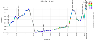
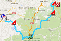
- start: after the sign in in the Avenue Victor Hugo, the fictiver start will be at 12.35PM and the riders will follow the Boulevard Gambetta, Boulevard Gally, Boulevard Laromiguière, Boulevard François Fabié, Boulevard Flaugergues, Boulevard Denys Puech, Boulevard de la République, Rue Saint-Cyrice, Avenue de Montpellier / D12, LE MONASTERE, D62 where they'll reach the km 0 at 12.45PM
- difficulties/climbs : Côte de Pont-de-Salars of the 4th category at km 20 (^ 780 m / 1.3 km @ 5.8%), Côte de Sauveterre of the 2nd category at km 146 (^ 1,014 m / 9 km @ 6%), the Côte de Chabrits of the 4th category at km 169.5 and the Côte de la Croix Neuve of the 2nd category just before the finish, at km 177 (^ 1,055 m / 3 km @ 10.1%)
- intermediate sprint : in Millau
- finish : on the track of the aérodrôme in Mende
- visited departments : Aveyron (12) from km 0 till km 106.5, Lozère (48) from km 106.5 till km 178.5
- main cities : Rodez, Pont-de-Salars, Castelnau-Pégayrols, Viala-du-Tarn, Rivière-sur-Tarn, Sainte-Enimie, Mende
15/ Sunday 19 July 2015 - Mende > Valence - 183 km
The 15th stage of the Tour de France uses the Massif central for a hilly stage starting in Mende. Right from the start, the riders will climb the Côte de Badaroux (3rd category) and then stay at the level they'll have reached there for about sixty kilometers before they successively climb the Col de Bez and the Col de la Croix de Bauzon, both 4th category.They'll dive towards Aubenas where they'll battle for the intermediate sprint before they go on with the climb of the Col de l'Escrinet, a 2nd category climb. On top of it, they'll be at a bit over 50 kilometers from the finish in Valence and the distance which separates them from the white line will mainly be done on a flat road after the descent of this climb, and then slightly uphill towards the finish.
Hereunder you'll find the time- and route schedule, the profile and the Google Maps version of the race route of this stage. Click on the images to open them.

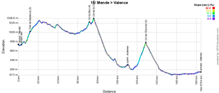
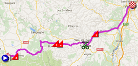
- start: after the sign in on the Place du Forail in Mende, the fictive start will be at 1PM and the riders will follow the Boulevard du Soubeyran, Avenue du Père Coudrin / N88 where they'll reach the km 0 at 1.05PM
- difficulties/climbs : Côte de Badaroux of the 3rd category at km 9.5 (^ 1,011 m / 4.6 km @ 5.1%), Col du Bez of the 4th category at km 69.5 (^ 1,223 m / 2.6 km @ 4%), Col de la Croix de Bauzon of the 4th category at km 73.5 (^ 1,308 m / 1.3 km @ 6.2%) and the Col de l'Escrinet of the 2nd category at km 126.5 (^ 787 m / 7.9 km @ 5.8%)
- intermediate sprint : in Aubenas at km 108
- finish : Avenue de Romans in Valence
- visited departments : Lozère (48) from km 0 till km 44.5 and from km 48 till km 53.5, Ardèche (07) from km 44.5 till km 48 and from km 53.5 till km 175, Drôme (26) from km 175 till km 183
- main cities : Mende, Aubenas, Privas, Valence
CONTINUE READING AFTER THIS ADVERTISEMENT
16/ Monday 20 July 2015 - Bourg-de-Péage > Gap - 201 km
In the 16th stage of the Tour de France 2015, starting in Bourg-de-Péage, the riders will find a slightly uphill race route from kilometer 50 in the city Crest. In this climb they'll battle for the sprint in Die and after 120 kilometers they'll start the climb of the first of the two 2nd category climbs of this stage, the Col de Cabre.After a first visit of the finish city of Gap, they'll climb the usual mountain in this area, the Col de Manse before they descend back to Gap and cross the finish line!
Hereunder you'll find the time- and route schedule, the profile and the Google Maps version of the race route of this stage. Click on the images to open them.

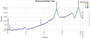
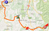
- start: after the sign in close to the Collège de l'Europe Jean Monnet, the fictive start will be at 12.25PM in Bourg-de-Péage and the riders will follow the Carrefour de l'Europe, the Avenue Antonin Vallon, Avenue des Martyrs de la Libération, Rue Andrevon, Rue du Vercors, Boulevard Alpes Provence / D2092N, Rue Saint-Nicolas, Côte des Cordeliers, Place Charles de Gaulle, Rue Jacquemart, ROMANS-SUR-ISERE, Cours Pierre Didier / Rond-Point Paul Deval / Côte des Masses / Avenue Berthelot / Route de Tain / D532 where they'll get to the km 0 at 12.40PM
- difficulties/climbs : Col de Cabre of the 2nd category at km 130 (^ 1,180 m / 9.1 km @ 4.6%), Col de Manse of the 2nd category at km 189 (^ 1,268 m / 8.9 km @ 5.6%)
- intermediate sprint : in Die at km 86.5
- finish : Avenue Maréchal Foch at the crossing with the Rue de la Gare in Gap
- visited departments : Drôme (26) from km 0 till km 130, Hautes-Alpes (05) from km 130 till km 201
- main cities : Bourg-de-Péage, Romans-sur-Isère, avoiding Valence, Crest, Die, Veynes, Gap
R2/ Tuesday 21 July 2015 - Gap
After this stage, the riders will stay where they were to enjoy the second rest day, in Gap.17/ Wednesday 22 July 2015 - Digne-les-Bains > Pra Loup - 161 km
While Pra Loup has never seen a Tour de France finish before, some riders will have a déjà-vu anyway during this stage starting in Digne-les-Bains. Indeed, on Thursday 11 June, it was exactly the same stage which was on the programme of the 5th day of the Critérium du Dauphiné when it was won in style by Romain Bardet (AG2R La Mondiale).Romain is one of the riders who'll participate in the Tour de France 2015 for AG2R La Mondiale. Will the French rider be able to redo his exploit in the battle with the big names of the Tour?
Anyway, after about forty kilometers, the riders arrive on the top of the first difficulty of the day, the Col des Lèques (3rd category) and about 25 kilometers furthere they'll already have climbed the Col des Toutes Aures (3rd category).
After the descent of this col, it becomes serious with the climb of the Col de la Colle Saint-Michel of the 2nd category and, closer to the finish, the Col d'Allos (1st category, 14 km @ 5.5%). When they'll have come down this mountain to the valley, only the final climb towards the finish in Pra Loup remains to be done.
Hereunder you'll find the time- and route schedule, the profile and the Google Maps version of the race route of this stage. Click on the images to open them.

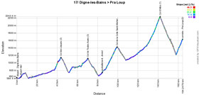

- start: the riders will take the fictive start at 12.45PM and they'll follow the Boulevard Gambetta, Avenue du Maréchal Juin, Route de Nice / N85 where they'll reach the km 0 at 12.55PM
- difficulties/climbs : Col des Lèques of the 3rd category at km 40 (^ 1,148 m / 6 km @ 5.3%), the Col de Toutes Aures of the 3rd category at km 67 (^ 1,124 m / 6.1 km @ 3.1%), the Col de la Colle Saint-Michel of the 2nd category at km 96 (^ 1,431 m / 11 km @ 5.2%), the Col d'Allos of the 1st category at km 139 (^ 2,250 m / 14 km @ 6.5%) which will be the highest point of this Tour de France 2015 and on top of this climb the first rider will thus be awarded the souvenir Henri Desgrange, since he'll be the first rider to reach the Tour's rooftop, and the final climb towards Pra Loup of the 2nd category at km 161 (^ 1,620 m / 6.2 km @ 6.5%)
- intermediate sprint : in Beauvezer at km 111
- finish : on top of Pra Loup, on the D109 next to the Office du Tourisme
- visited departments : Alpes-de-Haute-Provence (04) from km 0 till km 161
- main cities : Digne-les-Bains, Castellane, Thorame-Haute, Allos, Pra Loup
18/ Thursday 23 July 2015 - Gap > Saint-Jean-de-Maurienne - 186.5 km
Back to Gap for the 18th stage of the Tour de France 2015 this Thursday 23 July. Indeed, another mountain stage awaits the riders starting in Gap and it'll immediately start with the climb of the Col Bayard (2nd category).After about thirty kilometers, the riders will successively climb 3 climbs of the 3rd and a 2nd category mountain: the Rampe du Motty, the Côte de la Mure, the Col de Malissol and the Col de la Morte.
After the descent of the last one, the riders will battle for the intermediate sprint in Rioupéroux before they start the climb of the Col du Glandon just after Allemont. The descent of that mountain and a few flat kilometers further, the Lacets de Montvernier (2nd category), never before part of the Tour de France but already famous for the nice helicopter image it'll give, will bring them to a flat finish in Saint-Jean-de-Maurienne.
Hereunder you'll find the time- and route schedule, the profile and the Google Maps version of the race route of this stage. Click on the images to open them.

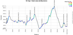

- start: after a sign in at the Alp'Arena, the riders will take the fictive start at 12.10PM in the Avenue Emile Didier (N94) and follow the Avenue d'Embrun, Rue de Nestle, Rue du Plan de Gap, Rue de Villarobert / D92, N85 where they'll reach the km at 12.10PM
- difficulties/climbs : Col Bayard of the 2nd category at km 6.5 (^ 1,264 m / 6.3 km @ 7%), Rampe du Motty of the 3rd category at km 35.5 (^ 982 m / 2.3 km @ 8.3%), Côte de la Mure of the 3rd category at km 60.5 (^ 803 m / 2.7 km @ 7.5%), Col de Malissol of the 3rd category at km 70.5 (^ 1,153 m / 2 km @ 8.7%), the Col de la Morte of the 2nd category at km 85 (^ 1,368 m / 3.1 km @ 8.4%), Col du Glandon hors category at km 147 (^ 1,924 m / 21.7 km @ 5.1%) and the Lacets de Montvernier of the 2nd category at km 176.5 (^ 782 m / 3.4 km @ 8.2%)
- intermediate sprint : in Rioupéroux at km 107.5
- finish : Rue Louis Sibué in Saint-Jean-de-Maurienne
- visited departments : Hautes-Alpes (05) from km 0 till km 35.5, Isère (38) from km 35.5 till km 140.5, Savoie (73) from km 140.5 till km 186.5
- main cities : Gap, Corps, Saint-Jean-de-Maurienne
CONTINUE READING AFTER THIS ADVERTISEMENT
19/ Friday 24 July 2015 - Saint-Jean-de-Maurienne > La Toussuire - 138 km
The start of this 19th stage will take place in the same city as the finish of the 18th, Saint-Jean-de-Maurienne and the stage will come back there juste before it goes off towards the finish.Indeed, after the start from Saint-Jean-de-Maurienne, the riders will visit Montvernier where they can have a look on the hairpins which brought them to the finish the day before, but this time they keep them on the left and go find the climb of the Col du Chaussy (1st category). Finishing the detour east via La Chambre they go on to the intermediate sprint in Epierre.
They'll cross the A43 highway and will go back south via Saint-Rémy-de-Maurienne and Saint-Etienne-de-Cuines. Continuing south-west, they'll continue to the climb of the Col du Glandon followed by the Col de la Croix de Fer (hors category) and then on to the Col du Mollard (2nd category). From Albiez-Montrond they go back to Saint-Jean-de-Maurienne where they almost make a U-turn just before they get back at the start location, to start the final climb towards La Toussuire (1st category).
Hereunder you'll find the time- and route schedule, the profile and the Google Maps version of the race route of this stage. Click on the images to open them.

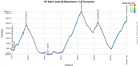

- start: the fictive start will be at 1.20PM in the Rue de la Libération / D906 in Saint-Jean-de-Maurienne and the riders will follow the Route de la Cascade / D77 in HERMILLON where they'll reach the km 0 at 1.25PM
- difficulties/climbs : Col du Chaussy of the 1st category at km 15.5 (^ 1,533 m / 15.4 km @ 6.3%), Col de la Croix de Fer hors category at km 83 (^ 2,067 m / 22.4 km @ 6.9%), Col du Mollard of the 2nd category (^ 1,638 m / 5.7 km @ 6.8%) and the final climb towards La Toussuire of the 1st category (^ 1,705 m / 18 km @ 6.1%)
- intermediate sprint : in Epierre at km 42
- finish : Rue des Fondeurs in La Toussuire
- visited departments : Savoie (73) from km 0 till km 138
- main cities : Saint-Jean-de-Maurienne, Hermillon, La Chambre, Epierre, Saint-Rémy-de-Maurienne, Saint-Etienne-de-Cuines, Saint-Alban-des-Villards, Albiez-Montrond, Saint-Jean-de-Maurienne, La Toussuire
20/ Saturday 25 July 2015 - Modane > Alpe d'Huez - 110.5 km
The forelast stage of the Tour de France 2015 would have been a perfect remake of the 19th stage of the Tour de France 2011 starting in Modane with the climb of the Col du Télégraphe (^ 1,566 m, 11.9 km @ 7.1%) and the Col du Galibier (^ 2,645 m, 17.7 km @ 6.9%) followed by a descent down to Le Bourg d'Oisans, and the final climb of the Alpe d'Huez with its famous 21 hairpins up to an altitude of 1,850 meters from which they'll already have an eye on the Arc de Triomphe in Paris! (13.8 km @ 8.1%).However, the landslides at the Tunnel du Chambon (see the dedicated page on the website of the Isère department for more information) on the D1091 between the Col du Lautaret and Le Bourg d'Oisans, came in unhandy for this stage. Unfortunately the impact on this road have gotten worse the past few days, thus preventing the road works to be done to open the tunnel again. As a consequence, this stage was modified: instead of turning left in Saint-Michel-de-Maurienne, the riders will continue straight till Saint-Jean-de-Maurienne where they'll turn left, towards the climb of the Col de la Croix de Fer (hors category), via another side than in the previous stage, and this will be the only climb of this cette stage in its final version, except for the final climb.
Via Oz and Allemont, the riders will get back on the initial road in Le Bourg d'Oisans where they'll battle for the intermediate sprint and where they start the climb of the famous 21 hairpins of the Alpe d'Huez (hors category).
Hereunder you'll find the time- and route schedule, the profile and the Google Maps version of the race route of this stage. Click on the images to open them.

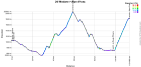
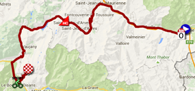
- start: the fictive start of this forelast stage will be at 1.10PM on the bridge over the Arc (D215) in Modane and the riders will follow the Avenue Emile Charvoz and the Rue Jean Jaurès / D1006 in FOURNEAUX where they'll get to the km 0 at 1.15PM
- difficulties/climbs : Col de la Croix de Fer hors category at km 56 (^ 2,067 m / 29 km @ 5.2%) and the final climb of the Alpe d'Huez hors category at km 110.5 (^ 1,850 m / 13.8 km @ 8.1%)
- intermediate sprint : on the D1091B in Le Bourg d'Oisans
- finish : Avenue du Rif Nel at the Alpe d'Huez
- visited departments : Savoie (73) from km 0 till km 62, Isère (38) from km 62 till km 110.5
- main cities : Modane, Saint-Michel-de-Maurienne, Saint-Jean-de-Maurienne, Saint-Jean-d'Arves, Saint-Sorlin-d'Arves, Oz, Allemond, le Bourg d'Oisans, Alpe d'Huez
21/ Sunday 26 July 2015 - Sèvres > Paris Champs-Elysées - 109.5 km
The riders will visit Issy-les-Moulineaux, not far from A.S.O.'s offices but what follows in this stage is different from usual. Indeed, the race will not enter Paris via sideroads of the Seine this year, but will turn around Boulogne-Billancourt and go via the Bois de Boulogne, to enter Paris at the Porte Maillot, at the very exact location where the Palais des Congrès is the usual place where the race route of the Tour de France gets announced every year.
From Porte Maillot, the riders will follow the Avenue de la Grande Armée and they'll already get on the Place Charles de Gaulle (Place de l'Etoile). They'll then follow the Avenue Marceau down to the Place de l'Alma where they'll turn right on the Avenue de New York. Crossing the Pont d'Iéna they'll have the best possible view on the Tour Eiffel. They'll continuent on the Quai Branly via the museum with the same name and then turn right on the Avenue Bousquet. Left on the Avenue de Tourville they'll cross in front of the shining rooftop of the Hôtel des Invalides and the Esplanade des Invalides will bring them to the Quai Anatole France and the Quai Voltaire. As usual, they'll then turn on the Pont du Caroussel and cross in front of the Louvre and then turn left on the Rue de Rivoli where they'll reach the final circuit which they'll have to do 10 times with the usual finish on the Champs-Elysées!
Hereunder you'll find the time- and route schedule, the profile and the Google Maps version of the race route of this stage. Click on the images to open them.


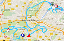
- start: after the sign in at the Complexe sportif Marcel Bec in Sèvres, the fictive start will be at 4.15PM and the riders will follow the Route du Pavillon l'Abbé and the Route du Pavé des Gardes, Route des Bois Blancs, Rue du Pavé de Meudon, CHAVILLE, Rue Anatole France / D53, Boulevard de la République, Rue Carnot, Rue du Coteau, Rue des Mortes Fontaines, Rue de la Monesse, VILLE D'AVRAY, Rue de la Justice, Chemin Desvallieres, Rue de la Ronce, Rue de Versailles / D985 where they'll reach the km 0 at 4.35PM
- difficulties/climbs : Côte de l'Observatoire of the 4th category at km 10.5 (^ 138 m / 2.2 km @ 4.1%)
- intermediate sprint : Paris, on the Champs-Elysées at km 55.5 just after the 3rd crossing of the finish line
- finish : Avenue des Champs-Elysées in Paris, after a final straight line of 400 m, 9 m large
- visited departments : Hauts-de-Seine (92) from km 0 till km 1.5 and from km 2.5 till km 19, Yvelines (91) from km 1.5 till km 2.5, Paris (75) from km 19 till km 109.5
- main cities : Sèvres, Chaville, Meudon, Vanves, Boulogne-Billancourt, Paris
The race route of the Tour de France 2015 in Google Earth
Do you prefer to see the complete race route of the Tour de France 2015 on a single map? Or would you like to do a virtual fly-over over the race route of one or more stages of this 102nd edition of the Tour de France? That's possible, by downloading the following KMZ file (a zipped KML file, because of its big size) and by opening it with Google Earth! ATTENTION - copyright: despite the fact that this KMZ file is made available for your own use, you must keep in mind that it is strictly forbidden to reproduce the contents of this KMZ file or of any other file (including the maps, profiles, KML files and others) which make up the race route of the Tour de France 2015. These contents are protected by copyright and I thus ask you to respect the huge amount of time spent on the creation of them. This protection concerns the reproduction of the maps of other elements in any way (as a map, a fly-over video of the maps or any other creation based on the contents published on velowire.com).
>> Download the race route of all the stages of the Tour de France 2015 in Google Earth (KMZ file)

Vond u dit artikel interessant? Laat het uw vrienden op Facebook weten door op de buttons hieronder te klikken!
23 comments | 63203 views
this publication is published in: Tour de France | Tour de France 2015 | OpenStreetMap/Google Maps/Google Earth


 by marco1988 over