This Sunday, the Critérium du Dauphiné 2011 -often still incorrectly called Critérium du Dauphiné Libéré by some- will start with an individual time trial in the city of Saint-Jean-de-Maurienne in Savoie. 1064.4 kilometers and one week further, the riders of the Critérium du Dauphiné will finish in La Toussuire.
In this article, you'll find all the details about the race route, with the route drawn on Google Maps/Google Earth, the stage profiles and the time- and route schedules. You'll also find the exact locations of the start and finish arches in each of the cities and the road the riders follow from the départ fictif to the départ réel.
This race, nicknamed "pure concentration of mountains" by its organisor, is a perfect preparation for the Tour de France 2011 and we'll thus see several riders who will start in the Tour in one month from now at the start of this race.
The parcours of the Critérium du Dauphiné 2011 on Google Maps
CONTINUE READING AFTER THIS ADVERTISEMENT
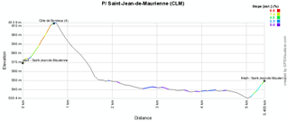
P/ Sunday 5 June 2011 - individual time trial Saint-Jean-de-Maurienne - 5.4 km
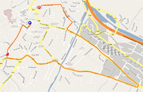
The Critérium du Dauphiné will as usual start with a prologue, an individual time trial, which will this year be run in the streets of Saint-Jean-de-Maurienne over a distance of 5.4 kilometers.The start ramp will be on the Place de la Cathédrale on the west side of the city and the riders will follow a V-formed route towards the east of the city where they turn at the Rond Point de la Résistance (roundabout). The finish will not be far from the place where the famous Opinel knives are manufacturerd, in the Rue Louis Sibué.
The first points for the polka dot jersey of the King of the Mountains classification will be awarded on top of the Côte de Bonrieux (4th category) during this time trial. At the end of this individual effort we'll know the name of the rider who will be the first to wear the yellow jersey of the Critérium du Dauphiné 2011.
The start of the first rider is planned to be at 11.40AM while the last rider will leave the start ramp at 2.35PM with riders starting every minute.
Below you'll find the route- and time schedule, the stage profile and the race route on Google Maps for this stage. Click on each of the images to open them.

1/ Monday 6 June 2011 - Albertville > Saint-Pierre-de-Chartreuse - 144 km
This first stage of the Critérium du Dauphiné 2011 will start with a first rather flat third part, even though it does contain the climb of the Côte de Saint-André (4) and of the Côte de Montagnole (3), followed by another climb of the 4th category, the Côte de la Bauche and the progressive climb towards Saint-Etienne-de-Crossey where the riders will start the final climb to the finish in Saint-Pierre-de-Chartreuse (2nd category).There will be no intermediate sprints and no feed zone in this stage.
The riders will gather for the start in the Cours de l'Hôtel de Ville where the départ fictif will be given at 12.30. They'll than follow the Rue Gambetta, Rue de la République, Avenue Victor Hugo, Avenue du Général de Gaulle, the D990 and the Route de Chambéry in Gilly-sur-Isère before getting to the place where the départ réel will be on the D990 at 4.6 kilometers from the start.
In Saint-Pierre-de-Chartreuse, the finish line will be drawn on the Place du Marché at the end of a 200 meters long final straight line and after a climb of 7.4 kilometers at 4,8% average.
Below you'll find the route- and time schedule, the stage profile and the race route on Google Maps for this stage. Click on each of the images to open them.


2/ Tuesday 7 June 2011 - Voiron > Lyon - 179 km
Rapidly after the start from Voiron, the riders of the Critérium du Dauphiné 2011 will climb the Côte de Miribel les Echelles where they'll get on the top after 20.5 kilometers. From there, the stage will be quite flat.Before they get in the feed zone in Optevoz, the riders will climb the Côte du Château de Saint-Julien and at 45 kilometers from the finish, they'll climb the Côte de Pérouges, next to the medieval city. Once they arrive in Lyon they still have to climb once more because the finish will be on top of the Côte de la Croix-Rousse.
The start will be at the crossing of the Cours Becquart-Castelbon and the Place du Général de Gaulle at 12.35 and the riders will follow the Cours Senozan, the Place de la République, the Rue Grande and the Avenue Gambetta before they get on the D520 where the départ réel will be given 1.6 kilometers from the start.
Below you'll find the route- and time schedule, the stage profile and the race route on Google Maps for this stage. Click on each of the images to open them.


3/ Wednesday 8 June 2011 - Grenoble (ITT) - 42.5 km
The Critérium du Dauphiné is usually a race where the best riders in the world get to compare and prepare for the Tour de France which will start a few weeks later. Its mountaineous profile and its place in the cycling calendar is perfect for this. This will even more be the case in 2011 because the 3rd stage will be an individual time trial which will use exactly the same race route as the final time trial of the Tour de France 2011 which will be in the Grande Boucle on Saturday 23 July!A perfect occasion to take some reference times, for the riders and directeurs sportifs but also for cycling fans, even though we should bear in mind that in this Critérium du Dauphiné this time trial is done after only 3 days in the race and with still half of the race to go while in the Tour it will be after 19 days of racing and at the end of the race.
After about 3 kilometers the road goes up and after about ten kilometers the first climb will finish in Brié-et-Angonnes. After the descent of this climb and the first intermediate timing point in Vizille, each of the riders will start the climb from the feed zone in Vaulnaveys-le-Haut towards Saint-Martin d'Uriage where the second intermediate timing point will be.
Below you'll find the route- and time schedule, the stage profile and the race route on Google Maps for this stage. Click on each of the images to open them.


CONTINUE READING AFTER THIS ADVERTISEMENT
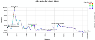
4/ Thursday 9 June 2011 - La Motte-Servolex > Mâcon - 173.5 km
The 4th stage is a hilly one with the start in La Motte-Servolex and the finish in Mâcon, 173.5 km and a visit of the Col du Chat, the Côte de Peyzieu, the feed zone in Sault-Brénaz and the climb of the Côte de Châtillon-la-Palud further.The start will be in the Rue des Allobroges from where the riders will follow the Avenue de Saint-Exupéry, the Avenue René Cassin and the Route du Tremblay to get on the D14 where the départ réel will be given 2.1 kilometers from the start.
The finish in Mâcon will be on the Quai Lamartine, at the end of a 1.9 kilometer long flat straight line (when the riders enter Mâcon, they'll first follow the Quai Jean Jaurès and the Quai du Maréchal de Lattre de Tassigny before turning around at the Avenue du Général de Gaulle and get back to the Quai Lamartine).
Below you'll find the route- and time schedule, the stage profile and the race route on Google Maps for this stage. Click on each of the images to open them.


5/ Friday 10 June 2011 - Parc des Oiseaux (Villars-les-Dombes) > Les Gets - 210 km
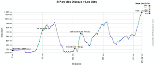
This 5th stage is the longest stage of the Critérium du Dauphiné 2011 and will take place between the Parc des Oiseaux (bird park) in Villars-les-Dombes and the ski station of Les Gets 210 kilometers further.It's not only the longest stage but also one of the most mountaineous with 3 climbs of the 2nd category: the Côte de Corlier, the Côte du Mont des Princes halfway in the stage and the final climb to Les Gets. After 99 kilometers, the riders can resource themselves in the feed zone in Mieugy.
The finish line in Les Gets will be drawn in the Rue du Centre at the end of a final 150 meters long straight line and a 10.7 kilometer long climb at 4.8% average.
Below you'll find the route- and time schedule, the stage profile and the race route on Google Maps for this stage. Click on each of the images to open them.


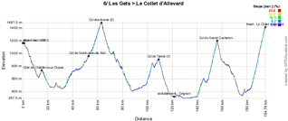
6/ Saturday 11 June 2011 - Les Gets > Le Collet d'Allevard - 192.5 km
This stage is probably the queen stage of this Critérium du Dauphiné with the start in the city where the race arrived the day before, Les Gets and the finish on top of the Collet d'Allevard 192.5 kilometers further.The menu of this stage will start with a descent from Les Gets followed by a short but steep climb of the Côte de Châtillon sur Cluses followed by the Col de Saint-Jean-de-Sixt and the Col des Aravis. Before the feed zone close to Grignon, the riders will climb the Col de Tamié and at 40 kilometers from the finish line they'll arrive on top of the Col du Grand Cucheron. After the descent of this col, they'll start the final 11.2 kilometer long climb at 8.4% average towards the Collet d'Allevard where they will cross the finish line on the Place de Malatrait after a final right turn and at the end of a 90 meter long straight line.
The start in Les Gets will be on the Place de la Maison des Gets at noon and the riders will follow the Rue du Centre, the Rue de Pressenage and the Route des Grandes Alpes. The départ réel will be on the D902 at 12.15, at 5.2 kilometers from the start.
Below you'll find the route- and time schedule, the stage profile and the race route on Google Maps for this stage. Click on each of the images to open them.


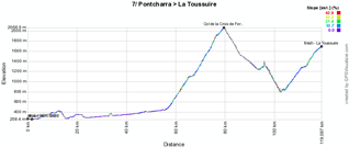
7/ Sunday 12 June 2011 - Pontcharra > La Toussuire - 117.5 km
This final stage is relatively short with its 117.5 kilometers and will bring back the riders to La Toussuire at about 15 kilometers from Saint-Jean-de-Maurienne where they started a week earlier.The start in Pontcharra will be in the Avenue de la Gare and to get to the départ réel, the riders who will have survived this one week race will follow the Rue Laurent Gayet and Avenue de Savoie before they get on the D523 which gets into the D923 where the départ réel will be at 2.9 kilometers from the start.
The first half of the stage is almost completely flat but after 54 kilometers things get more complicated with the climb of the Col de la Croix de Fer (Col du Glandon). After having climbed this mountain, which is hors catégorie, the descent will bring the riders to the foot of the final climb towards La Toussuire (1st category) where the finish line will be drawn on the Place Olympique at the end of a 700 meters long final straight line and after a 14.4 kilometer long climb at 5.9% average.
This is how the 63rd edition of the Critérium du Dauphiné will come to an end.
Below you'll find the route- and time schedule, the stage profile and the race route on Google Maps for this stage. Click on each of the images to open them.


The race route of the Critérium du Dauphiné 2011 in Google Earth
Do you prefer to see the full race route of the Critérium du Dauphiné 2011 in Google Earth and thus be able, for example, to do a virtual fly-over of the race route of each of the stages? Download the KML file below:
> Download the parcours of the Critérium du Dauphiné 2011 in Google Earth door Thomas Vergouwen
Vond u dit artikel interessant? Laat het uw vrienden op Facebook weten door op de buttons hieronder te klikken!
1 comment | 19578 views
this publication is published in: Critérium du Dauphiné 2011 | Criterium du Dauphiné | OpenStreetMap/Google Maps/Google Earth


 by marco1988 over
Dans le prologue ca a fait ..... BOOM !! Bravo les Pays Bas .